Map of Montgomery County - Montgomery County is a county located in the U.S. state of Virginia. Montgomery County Map showing cities, highways, important places and water bodies. Get Where is Montgomery County located in the map, major cities in Montgomery county, population, areas, and places of interest.
Map of Montgomery County, Virginia
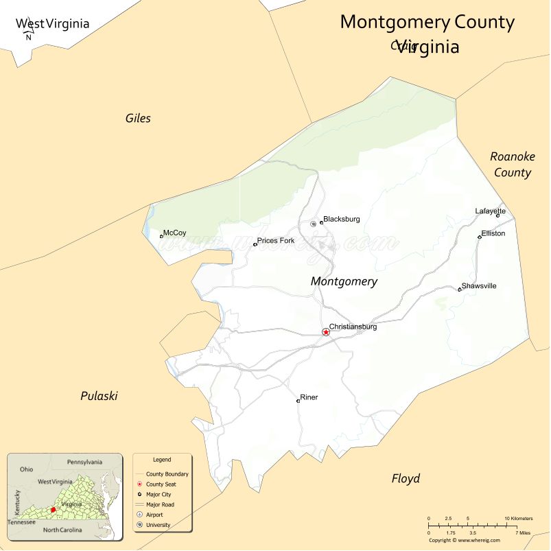
About Montgomery County Map, Alabama: The map showing the county boundary, county seat, major cities, highways, water bodies and neighbouring counties.
Related Virginia Links
| Virginia Map | Counties in Virginia | Cities in Virginia |
| Airports in Virginia | Zip Codes in Virginia | Where is Virginia |
| Where is Richmond | Where is Chesapeake | Where is Virginia Beach |
Map of Montgomery County, Virginia
Skamania County is a county located in the U.S. state of Washington. It`s county seat is Stevenson. As per 2020 census, the population of Skamania County was 12036 and population density of Skamania was square miles. According to the United States Census Bureau, the county has a total area of 1,656 sq mi (4,289 km2). Skamania County was established on 1854.
Montgomery County Facts
| Continent | North America |
| Country | United States |
| State | Virginia |
| County Seat | Christiansburg |
| Largest City/Town | Blacksburg |
| Established | 1777 |
| Total Area | 389 sq mi (1,008 sq km) |
| Land Area | 387 sq mi (1,003 sq km) |
| Water Area | 2 sq mi (5 sq km) |
| Population | 99,721 (Census 2020) |
| Population Density | 258 people per sq mi |
| Time Zone | Eastern (EST) |
| Major Highways | I-81, US-460, VA-114 |
| Major Rivers | New River |
| Neighboring Counties | Pulaski County, Floyd County, Roanoke County, Craig County, Giles County |
| Famous For | Virginia Tech, college town atmosphere, mountains |
| Top Attractions | Virginia Tech, Huckleberry Trail, Pandapas Pond |
| Official Website | Official Website |
About Montgomery County, Virginia
Montgomery County is located in the southwestern part of Virginia in the state of the United States, and was established in 1777. The county seat is Christiansburg, while Blacksburg is the largest town. The county lies in the Appalachian Mountains and is known for its scenic landscapes, educational institutions, and vibrant college-town culture.
Cities and Towns in Montgomery County, Virginia
| City/Town | Population (Census 2020) | Latitude & Longitude |
|---|---|---|
| Blacksburg (town) | 44,800 | 37.2296°N, 80.4139°W |
| Christiansburg (county seat, town) | 22,500 | 37.1299°N, 80.4089°W |
| Radford (partly in county) | 16,000 | 37.1318°N, 80.5764°W |
| Shawsville (CDP) | 1,400 | 37.1700°N, 80.2500°W |
| Elliston (CDP) | 1,000 | 37.2200°N, 80.2300°W |
| Lafayette (CDP) | 1,200 | 37.2300°N, 80.3000°W |
Golf Courses in Montgomery County, Virginia
| Golf Course | Location | Latitude & Longitude |
|---|---|---|
| Blacksburg Country Club | Blacksburg | 37.2300°N, 80.4200°W |
| Auburn Hills Golf Club | Riner area | 37.0600°N, 80.4400°W |
Roads and Highways in Montgomery County, Virginia
The county is a key transportation corridor in southwestern Virginia.
- I-81 – major interstate through the region
- US-460 – connects Blacksburg and Christiansburg to Roanoke
- VA-114 – regional route through the county
Neighboring Counties of Montgomery County
- Craig County (north)
- Roanoke County (east)
- Floyd County (south)
- Pulaski County (west)
- Giles County (northwest)
Top Attractions in Montgomery County, Virginia
The county offers outdoor recreation and cultural attractions.
- Virginia Tech – major university and campus attractions
- Huckleberry Trail – walking and biking trail
- Pandapas Pond – hiking, fishing, and recreation
- New River – kayaking and scenic views
- Coal Mining Heritage Park – local history
Distance from Montgomery County to Nearby Cities
- Blacksburg to Roanoke, VA – 45 mi (72 km)
- Blacksburg to Lynchburg, VA – 95 mi (153 km)
- Blacksburg to Richmond, VA – 240 mi (386 km)
- Blacksburg to Charlotte, NC – 160 mi (257 km)
- Blacksburg to Washington, DC – 270 mi (435 km)
FAQs about Montgomery County
Montgomery County is located in southwestern Virginia in the Appalachian Mountains.
The population of Montgomery County is 99,721 according to the 2020 Census.
The county is known for Virginia Tech, scenic mountains, and outdoor recreation.
The main highways include I-81, US-460, and Virginia Route 114.
Yes, Montgomery County has golf courses such as Blacksburg Country Club and Auburn Hills Golf Club.
- Accomack County Map, VA
- Albemarle County Map, VA
- Alleghany County Map, VA
- Amelia County Map, VA
- Amherst County Map, VA
- Appomattox County Map, VA
- Arlington County Map, VA
- Augusta County Map, VA
- Bath County Map, VA
- Bedford County Map, VA
- Bland County Map, VA
- Botetourt County Map, VA
- Brunswick County Map, VA
- Buchanan County Map, VA
- Buckingham County Map, VA
- Campbell County Map, VA
- Caroline County Map, VA
- Carroll County Map, VA
- Charles City County Map, VA
- Charlotte County Map, VA
- Chesterfield County Map, VA
- Clarke County Map, VA
- Craig County Map, VA
- Culpeper County Map, VA
- Cumberland County Map, VA
- Dickenson County Map, VA
- Dinwiddie County Map, VA
- Essex County Map, VA
- Fairfax County Map, VA
- Fauquier County Map, VA
- Floyd County Map, VA
- Fluvanna County Map, VA
- Franklin County Map, VA
- Frederick County Map, VA
- Giles County Map, VA
- Gloucester County Map, VA
- Goochland County Map, VA
- Grayson County Map, VA
- Greene County Map, VA
- Greensville County Map, VA
- Halifax County Map, VA
- Hanover County Map, VA
- Henrico County Map, VA
- Henry County Map, VA
- Highland County Map, VA
- Isle of Wight County Map, VA
- James City County Map, VA
- King and Queen County Map, VA
- King George County Map, VA
- King William County Map, VA
- Lancaster County Map, VA
- Lee County Map, VA
- Loudoun County Map, VA
- Louisa County Map, VA
- Lunenburg County Map, VA
- Madison County Map, VA
- Mathews County Map, VA
- Mecklenburg County Map, VA
- Middlesex County Map, VA
- Montgomery County Map, VA
- Nelson County Map, VA
- New Kent County Map, VA
- Northampton County Map, VA
- Northumberland County Map, VA
- Nottoway County Map, VA
- Orange County Map, VA
- Page County Map, VA
- Patrick County Map, VA
- Pittsylvania County Map, VA
- Powhatan County Map, VA
- Prince Edward County Map, VA
- Prince George County Map, VA
- Prince William County Map, VA
- Pulaski County Map, VA
- Rappahannock County Map, VA
- Richmond County Map, VA
- Roanoke County Map, VA
- Rockbridge County Map, VA
- Rockingham County Map, VA
- Russell County Map, VA
- Scott County Map, VA
- Shenandoah County Map, VA
- Smyth County Map, VA
- Southampton County Map, VA
- Spotsylvania County Map, VA
- Stafford County Map, VA
- Surry County Map, VA
- Sussex County Map, VA
- Tazewell County Map, VA
- Warren County Map, VA
- Washington County Map, VA
- Westmoreland County Map, VA
- Wise County Map, VA
- Wythe County Map, VA
- York County Map, VA
- Alexandria County Map, VA
- Bristol County Map, VA
- Buena Vista County Map, VA
- Charlottesville County Map, VA
- Chesapeake County Map, VA
- Colonial Heights County Map, VA
- Covington County Map, VA
- Danville County Map, VA
- Emporia County Map, VA
- Fairfax County Map, VA
- Falls Church County Map, VA
- Alabama Counties
- Alaska boroughs
- Arizona Counties
- Arkansas Counties
- California County Map
- Colorado Counties
- Connecticut Counties
- Delaware Counties
- Florida County Map
- Georgia County Map
- Hawaii Counties
- Idaho Counties
- Illinois Counties
- Indiana Counties
- Iowa Counties
- Kansas Counties
- Kentucky Counties
- Louisiana Counties
- Maine Counties
- Maryland Counties
- Massachusetts Counties
- Michigan County Map
- Minnesota Counties
- Mississippi Counties
- Missouri Counties
- Montana Counties
- Nebraska Counties
- Nevada Counties
- New York Counties
- New Hampshire Counties
- New Jersey Counties
- New Mexico Counties
- North Carolina Counties
- North Dakota Counties
- Ohio County Map
- Oklahoma Counties
- Oregon Counties
- Pennsylvania Counties
- Rhode Island Counties
- South Carolina Counties
- South Dakota Counties
- Map of Tennessee
- Texas County Map
- Utah Counties
- Vermont Counties
- Virginia Counties
- Washington Counties
- West Virginia Counties
- Wisconsin Counties
- Wyoming Counties