Map of Southampton County - Southampton County is a county located in the U.S. state of Virginia. Southampton County Map showing cities, highways, important places and water bodies. Get Where is Southampton County located in the map, major cities in Southampton county, population, areas, and places of interest.
Map of Southampton County, Virginia
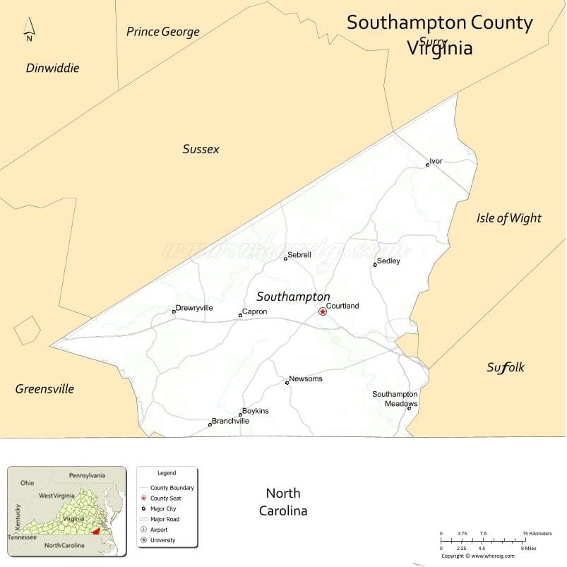
About Southampton County Map, Alabama: The map showing the county boundary, county seat, major cities, highways, water bodies and neighbouring counties.
Related Virginia Links
| Virginia Map | Counties in Virginia | Cities in Virginia |
| Airports in Virginia | Zip Codes in Virginia | Where is Virginia |
| Where is Richmond | Where is Chesapeake | Where is Virginia Beach |
Map of Southampton County, Virginia
Hancock County is a county located in the U.S. state of West Virginia. It`s county seat is New Cumberland. As per 2020 census, the population of Hancock County was 28656 and population density of Hancock was square miles. According to the United States Census Bureau, the county has a total area of 83 sq mi (215 km2). Hancock County was established on 1848.
Southampton County Facts
| Continent | North America |
| Country | United States |
| State | Virginia |
| County Seat | Courtland |
| Largest City/Town | Franklin (independent city, adjacent) |
| Established | 1749 |
| Total Area | 602 sq mi (1,559 sq km) |
| Land Area | 599 sq mi (1,551 sq km) |
| Water Area | 3 sq mi (8 sq km) |
| Population | 17,996 (Census 2020) |
| Population Density | 30 people per sq mi |
| Time Zone | Eastern (EST) |
| Major Highways | US-58, US-258, VA-35 |
| Major Rivers | Nottoway River, Blackwater River |
| Neighboring Counties | Sussex County, Isle of Wight County, Greensville County, Brunswick County, Hertford County (NC), Northampton County (NC) |
| Famous For | Nat Turner Rebellion history, agriculture, rural landscapes |
| Top Attractions | Nat Turner Historic Site, Southampton Agricultural & Forestry Museum, Blackwater River |
| Official Website | Official Website |
About Southampton County, Virginia
Southampton County is located in the southeastern part of Virginia in the state of the United States, and was established in 1749. The county seat is Courtland, while the independent city of Franklin lies adjacent and serves as a major nearby urban center. The county lies along the North Carolina border and is known for its agricultural economy, historical significance, and rural character.
Cities and Towns in Southampton County, Virginia
| City/Town | Population (Census 2020) | Latitude & Longitude |
|---|---|---|
| Courtland (county seat, town) | 1,300 | 36.7100°N, 77.0700°W |
| Capron (town) | 200 | 36.7000°N, 77.2000°W |
| Boykins (town) | 600 | 36.5800°N, 77.2000°W |
| Ivor (town) | 500 | 36.9200°N, 76.9200°W |
| Newsoms (town) | 300 | 36.6200°N, 77.1200°W |
| Drewryville (CDP) | 200 | 36.7100°N, 77.3000°W |
Golf Courses in Southampton County, Virginia
| Golf Course | Location | Latitude & Longitude |
|---|---|---|
| Southampton Country Club | Courtland area | 36.7100°N, 77.0700°W |
| Franklin Country Club (nearby) | Franklin | 36.6800°N, 76.9200°W |
Roads and Highways in Southampton County, Virginia
The county is served by key highways in southeastern Virginia.
- US-58 – major east-west route
- US-258 – connects to surrounding regions
- VA-35 – regional highway
Neighboring Counties of Southampton County
- Isle of Wight County (north)
- Sussex County (northeast)
- Greensville County (west)
- Brunswick County (southwest)
- Hertford County, North Carolina (south)
- Northampton County, North Carolina (south)
Top Attractions in Southampton County, Virginia
The county offers historical sites and natural scenery.
- Nat Turner Historic Site – location tied to 1831 rebellion
- Southampton Agricultural & Forestry Museum – local history
- Blackwater River – kayaking and fishing
- Nottoway River – scenic waterway
- Rural farmland – scenic countryside
Distance from Southampton County to Nearby Cities
- Courtland to Norfolk, VA – 60 mi (97 km)
- Courtland to Richmond, VA – 80 mi (129 km)
- Courtland to Virginia Beach, VA – 70 mi (113 km)
- Courtland to Raleigh, NC – 100 mi (161 km)
- Courtland to Washington, DC – 180 mi (290 km)
FAQs about Southampton County
Southampton County is located in southeastern Virginia along the North Carolina border.
The population of Southampton County is 17,996 according to the 2020 Census.
The county is known for its agricultural heritage and its connection to the Nat Turner Rebellion.
The main highways include US-58, US-258, and Virginia Route 35.
Yes, Southampton County has golf courses such as Southampton Country Club.
- Accomack County Map, VA
- Albemarle County Map, VA
- Alleghany County Map, VA
- Amelia County Map, VA
- Amherst County Map, VA
- Appomattox County Map, VA
- Arlington County Map, VA
- Augusta County Map, VA
- Bath County Map, VA
- Bedford County Map, VA
- Bland County Map, VA
- Botetourt County Map, VA
- Brunswick County Map, VA
- Buchanan County Map, VA
- Buckingham County Map, VA
- Campbell County Map, VA
- Caroline County Map, VA
- Carroll County Map, VA
- Charles City County Map, VA
- Charlotte County Map, VA
- Chesterfield County Map, VA
- Clarke County Map, VA
- Craig County Map, VA
- Culpeper County Map, VA
- Cumberland County Map, VA
- Dickenson County Map, VA
- Dinwiddie County Map, VA
- Essex County Map, VA
- Fairfax County Map, VA
- Fauquier County Map, VA
- Floyd County Map, VA
- Fluvanna County Map, VA
- Franklin County Map, VA
- Frederick County Map, VA
- Giles County Map, VA
- Gloucester County Map, VA
- Goochland County Map, VA
- Grayson County Map, VA
- Greene County Map, VA
- Greensville County Map, VA
- Halifax County Map, VA
- Hanover County Map, VA
- Henrico County Map, VA
- Henry County Map, VA
- Highland County Map, VA
- Isle of Wight County Map, VA
- James City County Map, VA
- King and Queen County Map, VA
- King George County Map, VA
- King William County Map, VA
- Lancaster County Map, VA
- Lee County Map, VA
- Loudoun County Map, VA
- Louisa County Map, VA
- Lunenburg County Map, VA
- Madison County Map, VA
- Mathews County Map, VA
- Mecklenburg County Map, VA
- Middlesex County Map, VA
- Montgomery County Map, VA
- Nelson County Map, VA
- New Kent County Map, VA
- Northampton County Map, VA
- Northumberland County Map, VA
- Nottoway County Map, VA
- Orange County Map, VA
- Page County Map, VA
- Patrick County Map, VA
- Pittsylvania County Map, VA
- Powhatan County Map, VA
- Prince Edward County Map, VA
- Prince George County Map, VA
- Prince William County Map, VA
- Pulaski County Map, VA
- Rappahannock County Map, VA
- Richmond County Map, VA
- Roanoke County Map, VA
- Rockbridge County Map, VA
- Rockingham County Map, VA
- Russell County Map, VA
- Scott County Map, VA
- Shenandoah County Map, VA
- Smyth County Map, VA
- Southampton County Map, VA
- Spotsylvania County Map, VA
- Stafford County Map, VA
- Surry County Map, VA
- Sussex County Map, VA
- Tazewell County Map, VA
- Warren County Map, VA
- Washington County Map, VA
- Westmoreland County Map, VA
- Wise County Map, VA
- Wythe County Map, VA
- York County Map, VA
- Alexandria County Map, VA
- Bristol County Map, VA
- Buena Vista County Map, VA
- Charlottesville County Map, VA
- Chesapeake County Map, VA
- Colonial Heights County Map, VA
- Covington County Map, VA
- Danville County Map, VA
- Emporia County Map, VA
- Fairfax County Map, VA
- Falls Church County Map, VA
- Alabama Counties
- Alaska boroughs
- Arizona Counties
- Arkansas Counties
- California County Map
- Colorado Counties
- Connecticut Counties
- Delaware Counties
- Florida County Map
- Georgia County Map
- Hawaii Counties
- Idaho Counties
- Illinois Counties
- Indiana Counties
- Iowa Counties
- Kansas Counties
- Kentucky Counties
- Louisiana Counties
- Maine Counties
- Maryland Counties
- Massachusetts Counties
- Michigan County Map
- Minnesota Counties
- Mississippi Counties
- Missouri Counties
- Montana Counties
- Nebraska Counties
- Nevada Counties
- New York Counties
- New Hampshire Counties
- New Jersey Counties
- New Mexico Counties
- North Carolina Counties
- North Dakota Counties
- Ohio County Map
- Oklahoma Counties
- Oregon Counties
- Pennsylvania Counties
- Rhode Island Counties
- South Carolina Counties
- South Dakota Counties
- Map of Tennessee
- Texas County Map
- Utah Counties
- Vermont Counties
- Virginia Counties
- Washington Counties
- West Virginia Counties
- Wisconsin Counties
- Wyoming Counties