Map of Charlotte County - Charlotte County is a county located in the U.S. state of Virginia. Charlotte County Map showing cities, highways, important places and water bodies. Get Where is Charlotte County located in the map, major cities in Charlotte county, population, areas, and places of interest.
Map of Charlotte County, Virginia
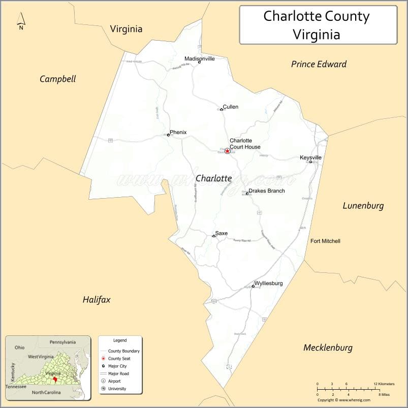
About Charlotte County Map, Alabama: The map showing the county boundary, county seat, major cities, highways, water bodies and neighbouring counties.
Related Virginia Links
| Virginia Map | Counties in Virginia | Cities in Virginia |
| Airports in Virginia | Zip Codes in Virginia | Where is Virginia |
| Where is Richmond | Where is Chesapeake | Where is Virginia Beach |
Map of Charlotte County, Virginia
Norton County is a county located in the U.S. state of Virginia. It`s county seat is N/A. As per 2020 census, the population of Norton County was 3666 and population density of Norton was square miles. According to the United States Census Bureau, the county has a total area of 7 sq mi (18 km2). Norton County was established on 1954.
Charlotte County Facts
| Continent | North America |
| Country | United States |
| State | Virginia |
| County Seat | Charlotte Court House |
| Largest City/Town | Keysville |
| Established | 1764 |
| Total Area | 478 sq mi (1,238 sq km) |
| Land Area | 475 sq mi (1,230 sq km) |
| Water Area | 3 sq mi (8 sq km) |
| Population | 12,586 (Census 2020) |
| Population Density | 26 people per sq mi |
| Time Zone | Eastern (EST) |
| Major Highways | US-15, US-360, SR-47 |
| Major Rivers | Roanoke River, Staunton River |
| Neighboring Counties | Prince Edward County, Lunenburg County, Mecklenburg County, Halifax County, Campbell County, Appomattox County |
| Famous For | Rural landscapes, Civil War history, agriculture |
| Top Attractions | Sailor’s Creek Battlefield, Staunton River State Park, historic courthouse area |
| Official Website | Official Website |
About Charlotte County, Virginia
Charlotte County is located in the south-central part of Virginia in the state of the United States, and was established in 1764. The county seat is Charlotte Court House, while Keysville is the largest town. The county lies in the Piedmont region and is characterized by rolling farmland, forests, and rivers, along with significant historical sites tied to the Civil War.
Cities and Towns in Charlotte County, Virginia
| City/Town | Population (Census 2020) | Latitude & Longitude |
|---|---|---|
| Charlotte Court House (county seat) | 603 | 37.0563°N, 78.6383°W |
| Keysville (town) | 832 | 37.0393°N, 78.4664°W |
| Drakes Branch (town) | 530 | 36.9957°N, 78.6022°W |
| Phenix (CDP) | 200 | 37.0800°N, 78.7500°W |
| Saxe (CDP) | 300 | 36.9490°N, 78.6800°W |
| Cullen (CDP) | 200 | 37.1310°N, 78.6460°W |
| Red Oak (CDP) | 150 | 36.8250°N, 78.6300°W |
Golf Courses in Charlotte County, Virginia
| Golf Course | Location | Latitude & Longitude |
|---|---|---|
| No major golf courses within county limits | N/A | N/A |
| Kinderton Country Club (nearby) | Clarksville area | 36.6270°N, 78.5550°W |
Roads and Highways in Charlotte County, Virginia
The county is served by highways connecting it to surrounding rural and urban areas.
- US-15 – major north-south route through the county
- US-360 – connects Charlotte County to Richmond and Southside Virginia
- SR-47 – links local communities and rural areas
Neighboring Counties of Charlotte County
- Prince Edward County (north)
- Appomattox County (northwest)
- Campbell County (west)
- Halifax County (south)
- Mecklenburg County (southwest)
- Lunenburg County (east)
Top Attractions in Charlotte County, Virginia
The county offers historic sites and outdoor recreation.
- Sailor’s Creek Battlefield Historical State Park – major Civil War site
- Staunton River State Park – camping, hiking, and stargazing
- Red Hill Patrick Henry National Memorial (nearby) – home of Patrick Henry
- Historic Charlotte Court House – preserved courthouse and historic buildings
- Roanoke River – fishing and scenic recreation
- Local farms and countryside – rural charm and agricultural heritage
Distance from Charlotte County to Nearby Cities
- Charlotte Court House to Farmville, VA – 20 mi (32 km)
- Charlotte Court House to Lynchburg, VA – 45 mi (72 km)
- Charlotte Court House to Richmond, VA – 90 mi (145 km)
- Charlotte Court House to Danville, VA – 50 mi (80 km)
- Charlotte Court House to Roanoke, VA – 100 mi (161 km)
FAQs about Charlotte County
Charlotte County is located in south-central Virginia within the Piedmont region.
The population of Charlotte County is 12,586 according to the 2020 Census.
The county is known for its Civil War history, rural landscapes, and state parks.
The main highways include US-15, US-360, and State Route 47.
No major golf courses are located within Charlotte County, but nearby areas offer golf facilities.
- Accomack County Map, VA
- Albemarle County Map, VA
- Alleghany County Map, VA
- Amelia County Map, VA
- Amherst County Map, VA
- Appomattox County Map, VA
- Arlington County Map, VA
- Augusta County Map, VA
- Bath County Map, VA
- Bedford County Map, VA
- Bland County Map, VA
- Botetourt County Map, VA
- Brunswick County Map, VA
- Buchanan County Map, VA
- Buckingham County Map, VA
- Campbell County Map, VA
- Caroline County Map, VA
- Carroll County Map, VA
- Charles City County Map, VA
- Charlotte County Map, VA
- Chesterfield County Map, VA
- Clarke County Map, VA
- Craig County Map, VA
- Culpeper County Map, VA
- Cumberland County Map, VA
- Dickenson County Map, VA
- Dinwiddie County Map, VA
- Essex County Map, VA
- Fairfax County Map, VA
- Fauquier County Map, VA
- Floyd County Map, VA
- Fluvanna County Map, VA
- Franklin County Map, VA
- Frederick County Map, VA
- Giles County Map, VA
- Gloucester County Map, VA
- Goochland County Map, VA
- Grayson County Map, VA
- Greene County Map, VA
- Greensville County Map, VA
- Halifax County Map, VA
- Hanover County Map, VA
- Henrico County Map, VA
- Henry County Map, VA
- Highland County Map, VA
- Isle of Wight County Map, VA
- James City County Map, VA
- King and Queen County Map, VA
- King George County Map, VA
- King William County Map, VA
- Lancaster County Map, VA
- Lee County Map, VA
- Loudoun County Map, VA
- Louisa County Map, VA
- Lunenburg County Map, VA
- Madison County Map, VA
- Mathews County Map, VA
- Mecklenburg County Map, VA
- Middlesex County Map, VA
- Montgomery County Map, VA
- Nelson County Map, VA
- New Kent County Map, VA
- Northampton County Map, VA
- Northumberland County Map, VA
- Nottoway County Map, VA
- Orange County Map, VA
- Page County Map, VA
- Patrick County Map, VA
- Pittsylvania County Map, VA
- Powhatan County Map, VA
- Prince Edward County Map, VA
- Prince George County Map, VA
- Prince William County Map, VA
- Pulaski County Map, VA
- Rappahannock County Map, VA
- Richmond County Map, VA
- Roanoke County Map, VA
- Rockbridge County Map, VA
- Rockingham County Map, VA
- Russell County Map, VA
- Scott County Map, VA
- Shenandoah County Map, VA
- Smyth County Map, VA
- Southampton County Map, VA
- Spotsylvania County Map, VA
- Stafford County Map, VA
- Surry County Map, VA
- Sussex County Map, VA
- Tazewell County Map, VA
- Warren County Map, VA
- Washington County Map, VA
- Westmoreland County Map, VA
- Wise County Map, VA
- Wythe County Map, VA
- York County Map, VA
- Alexandria County Map, VA
- Bristol County Map, VA
- Buena Vista County Map, VA
- Charlottesville County Map, VA
- Chesapeake County Map, VA
- Colonial Heights County Map, VA
- Covington County Map, VA
- Danville County Map, VA
- Emporia County Map, VA
- Fairfax County Map, VA
- Falls Church County Map, VA
- Alabama Counties
- Alaska boroughs
- Arizona Counties
- Arkansas Counties
- California County Map
- Colorado Counties
- Connecticut Counties
- Delaware Counties
- Florida County Map
- Georgia County Map
- Hawaii Counties
- Idaho Counties
- Illinois Counties
- Indiana Counties
- Iowa Counties
- Kansas Counties
- Kentucky Counties
- Louisiana Counties
- Maine Counties
- Maryland Counties
- Massachusetts Counties
- Michigan County Map
- Minnesota Counties
- Mississippi Counties
- Missouri Counties
- Montana Counties
- Nebraska Counties
- Nevada Counties
- New York Counties
- New Hampshire Counties
- New Jersey Counties
- New Mexico Counties
- North Carolina Counties
- North Dakota Counties
- Ohio County Map
- Oklahoma Counties
- Oregon Counties
- Pennsylvania Counties
- Rhode Island Counties
- South Carolina Counties
- South Dakota Counties
- Map of Tennessee
- Texas County Map
- Utah Counties
- Vermont Counties
- Virginia Counties
- Washington Counties
- West Virginia Counties
- Wisconsin Counties
- Wyoming Counties