Map of Alleghany County - Alleghany County is a county located in the U.S. state of Virginia. Alleghany County Map showing cities, highways, important places and water bodies. Get Where is Alleghany County located in the map, major cities in Alleghany county, population, areas, and places of interest.
Map of Alleghany County, Virginia
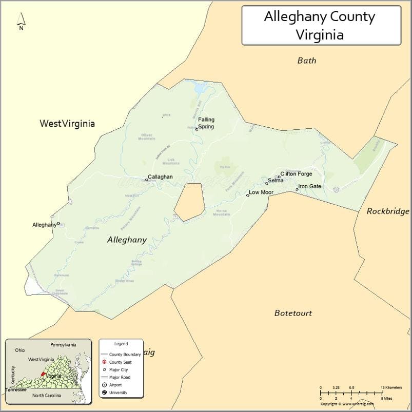
About Alleghany County Map, Alabama: The map showing the county boundary, county seat, major cities, highways, water bodies and neighbouring counties.
Related Virginia Links
| Virginia Map | Counties in Virginia | Cities in Virginia |
| Airports in Virginia | Zip Codes in Virginia | Where is Virginia |
| Where is Richmond | Where is Chesapeake | Where is Virginia Beach |
Map of Alleghany County, Virginia
Danville County is a county located in the U.S. state of Virginia. It`s county seat is N/A. As per 2020 census, the population of Danville County was 42215 and population density of Danville was square miles. According to the United States Census Bureau, the county has a total area of 43 sq mi (111 km2). Danville County was established on 1870[12].
Alleghany County Facts
| Continent | North America |
| Country | United States |
| State | Virginia |
| County Seat | Covington |
| Largest City/Town | Covington |
| Established | 1822 |
| Total Area | 449 sq mi (1,163 sq km) |
| Land Area | 445 sq mi (1,153 sq km) |
| Water Area | 4 sq mi (10 sq km) |
| Population | 15,223 (Census 2020) |
| Population Density | 34 people per sq mi |
| Time Zone | Eastern (EST) |
| Major Highways | I-64, US-60, US-220 |
| Major Rivers | Jackson River, Cowpasture River |
| Neighboring Counties | Bath County, Rockbridge County, Botetourt County, Craig County, Greenbrier County (WV) |
| Famous For | Mountain scenery, outdoor recreation, Jackson River |
| Top Attractions | Douthat State Park, Jackson River Scenic Trail, George Washington National Forest |
| Official Website | Official Website |
About Alleghany County, Virginia
Alleghany County is located in the western part of Virginia in the state of the United States, and was established in 1822. The county seat is Covington, which also serves as the largest city and economic center. The region lies within the Appalachian Mountains and is known for its forests, rivers, and outdoor recreation opportunities.
Cities and Towns in Alleghany County, Virginia
| City/Town | Population (Census 2020) | Latitude & Longitude |
|---|---|---|
| Covington (county seat) | 5,737 | 37.7937°N, 79.9939°W |
| Clifton Forge | 3,737 | 37.8162°N, 79.8248°W |
| Iron Gate | 366 | 37.7982°N, 79.7862°W |
| Low Moor (CDP) | 1,700 | 37.7831°N, 79.8856°W |
| Selma (CDP) | 300 | 37.8201°N, 79.8106°W |
| Falling Spring (CDP) | 250 | 37.8810°N, 79.9763°W |
| Longdale Furnace (CDP) | 150 | 37.7790°N, 79.9158°W |
Golf Courses in Alleghany County, Virginia
| Golf Course | Location | Latitude & Longitude |
|---|---|---|
| Clifton Forge Golf Club | Clifton Forge | 37.8160°N, 79.8275°W |
| Lake Moomaw Golf Area (recreational course) | Near Covington | 37.9695°N, 79.9545°W |
Roads and Highways in Alleghany County, Virginia
The county is connected by key mountain highways that link it to surrounding regions.
- I-64 – east-west interstate connecting Covington with Lexington and Charleston, WV
- US-60 – scenic route through mountain valleys and historic communities
- US-220 – north-south highway linking to Roanoke and West Virginia
Neighboring Counties of Alleghany County
- Bath County (north)
- Rockbridge County (east)
- Botetourt County (southeast)
- Craig County (south)
- Greenbrier County, West Virginia (west)
Top Attractions in Alleghany County, Virginia
The county is a destination for nature lovers and outdoor enthusiasts.
- Douthat State Park – one of Virginia’s oldest parks with hiking, camping, and a scenic lake
- Jackson River Scenic Trail – popular for biking and walking along the river
- George Washington National Forest – vast forest area for hiking and wildlife viewing
- Lake Moomaw – boating, fishing, and camping destination
- Falling Spring Falls – beautiful waterfall just north of Covington
- Humpback Bridge – historic covered bridge nearby
- Clifton Forge Historic District – charming downtown with local shops and history
Distance from Alleghany County to Nearby Cities
- Covington to Roanoke, VA – 65 mi (105 km)
- Covington to Lexington, VA – 40 mi (64 km)
- Covington to Charleston, WV – 120 mi (193 km)
- Covington to Staunton, VA – 60 mi (97 km)
- Covington to Richmond, VA – 190 mi (306 km)
FAQs about Alleghany County
Alleghany County is located in western Virginia within the Appalachian Mountain region.
The population of Alleghany County is 15,223 according to the 2020 Census.
The county is known for its mountain landscapes, rivers, and outdoor recreation areas like Douthat State Park.
The main highways include Interstate 64, US-60, and US-220.
Yes, the county includes golf facilities such as Clifton Forge Golf Club and recreational courses near Lake Moomaw.
- Accomack County Map, VA
- Albemarle County Map, VA
- Alleghany County Map, VA
- Amelia County Map, VA
- Amherst County Map, VA
- Appomattox County Map, VA
- Arlington County Map, VA
- Augusta County Map, VA
- Bath County Map, VA
- Bedford County Map, VA
- Bland County Map, VA
- Botetourt County Map, VA
- Brunswick County Map, VA
- Buchanan County Map, VA
- Buckingham County Map, VA
- Campbell County Map, VA
- Caroline County Map, VA
- Carroll County Map, VA
- Charles City County Map, VA
- Charlotte County Map, VA
- Chesterfield County Map, VA
- Clarke County Map, VA
- Craig County Map, VA
- Culpeper County Map, VA
- Cumberland County Map, VA
- Dickenson County Map, VA
- Dinwiddie County Map, VA
- Essex County Map, VA
- Fairfax County Map, VA
- Fauquier County Map, VA
- Floyd County Map, VA
- Fluvanna County Map, VA
- Franklin County Map, VA
- Frederick County Map, VA
- Giles County Map, VA
- Gloucester County Map, VA
- Goochland County Map, VA
- Grayson County Map, VA
- Greene County Map, VA
- Greensville County Map, VA
- Halifax County Map, VA
- Hanover County Map, VA
- Henrico County Map, VA
- Henry County Map, VA
- Highland County Map, VA
- Isle of Wight County Map, VA
- James City County Map, VA
- King and Queen County Map, VA
- King George County Map, VA
- King William County Map, VA
- Lancaster County Map, VA
- Lee County Map, VA
- Loudoun County Map, VA
- Louisa County Map, VA
- Lunenburg County Map, VA
- Madison County Map, VA
- Mathews County Map, VA
- Mecklenburg County Map, VA
- Middlesex County Map, VA
- Montgomery County Map, VA
- Nelson County Map, VA
- New Kent County Map, VA
- Northampton County Map, VA
- Northumberland County Map, VA
- Nottoway County Map, VA
- Orange County Map, VA
- Page County Map, VA
- Patrick County Map, VA
- Pittsylvania County Map, VA
- Powhatan County Map, VA
- Prince Edward County Map, VA
- Prince George County Map, VA
- Prince William County Map, VA
- Pulaski County Map, VA
- Rappahannock County Map, VA
- Richmond County Map, VA
- Roanoke County Map, VA
- Rockbridge County Map, VA
- Rockingham County Map, VA
- Russell County Map, VA
- Scott County Map, VA
- Shenandoah County Map, VA
- Smyth County Map, VA
- Southampton County Map, VA
- Spotsylvania County Map, VA
- Stafford County Map, VA
- Surry County Map, VA
- Sussex County Map, VA
- Tazewell County Map, VA
- Warren County Map, VA
- Washington County Map, VA
- Westmoreland County Map, VA
- Wise County Map, VA
- Wythe County Map, VA
- York County Map, VA
- Alexandria County Map, VA
- Bristol County Map, VA
- Buena Vista County Map, VA
- Charlottesville County Map, VA
- Chesapeake County Map, VA
- Colonial Heights County Map, VA
- Covington County Map, VA
- Danville County Map, VA
- Emporia County Map, VA
- Fairfax County Map, VA
- Falls Church County Map, VA
- Alabama Counties
- Alaska boroughs
- Arizona Counties
- Arkansas Counties
- California County Map
- Colorado Counties
- Connecticut Counties
- Delaware Counties
- Florida County Map
- Georgia County Map
- Hawaii Counties
- Idaho Counties
- Illinois Counties
- Indiana Counties
- Iowa Counties
- Kansas Counties
- Kentucky Counties
- Louisiana Counties
- Maine Counties
- Maryland Counties
- Massachusetts Counties
- Michigan County Map
- Minnesota Counties
- Mississippi Counties
- Missouri Counties
- Montana Counties
- Nebraska Counties
- Nevada Counties
- New York Counties
- New Hampshire Counties
- New Jersey Counties
- New Mexico Counties
- North Carolina Counties
- North Dakota Counties
- Ohio County Map
- Oklahoma Counties
- Oregon Counties
- Pennsylvania Counties
- Rhode Island Counties
- South Carolina Counties
- South Dakota Counties
- Map of Tennessee
- Texas County Map
- Utah Counties
- Vermont Counties
- Virginia Counties
- Washington Counties
- West Virginia Counties
- Wisconsin Counties
- Wyoming Counties