Map of Chesterfield County - Chesterfield County is a county located in the U.S. state of Virginia. Chesterfield County Map showing cities, highways, important places and water bodies. Get Where is Chesterfield County located in the map, major cities in Chesterfield county, population, areas, and places of interest.
Map of Chesterfield County, Virginia
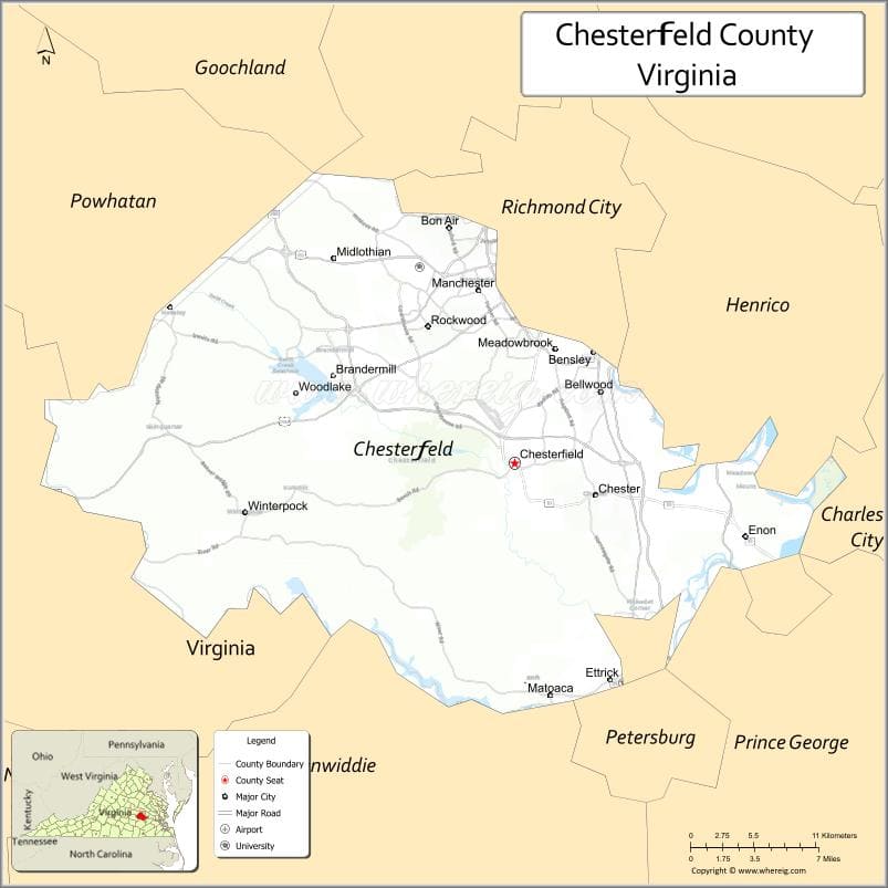
About Chesterfield County Map, Alabama: The map showing the county boundary, county seat, major cities, highways, water bodies and neighbouring counties.
Related Virginia Links
| Virginia Map | Counties in Virginia | Cities in Virginia |
| Airports in Virginia | Zip Codes in Virginia | Where is Virginia |
| Where is Richmond | Where is Chesapeake | Where is Virginia Beach |
Map of Chesterfield County, Virginia
Petersburg County is a county located in the U.S. state of Virginia. It`s county seat is N/A. As per 2020 census, the population of Petersburg County was 33429 and population density of Petersburg was square miles. According to the United States Census Bureau, the county has a total area of 23 sq mi (60 km2). Petersburg County was established on 1870[12].
Chesterfield County Facts
| Continent | North America |
| Country | United States |
| State | Virginia |
| County Seat | Chesterfield Court House |
| Largest City/Town | Chester |
| Established | 1749 |
| Total Area | 437 sq mi (1,132 sq km) |
| Land Area | 423 sq mi (1,096 sq km) |
| Water Area | 14 sq mi (36 sq km) |
| Population | 364,548 (Census 2020) |
| Population Density | 860 people per sq mi |
| Time Zone | Eastern (EST) |
| Major Highways | I-95, I-295, US-60, US-360 |
| Major Rivers | James River, Appomattox River |
| Neighboring Counties | Henrico County, Powhatan County, Amelia County, Dinwiddie County, Prince George County |
| Famous For | Suburban Richmond, historical sites, parks and recreation |
| Top Attractions | Pocahontas State Park, Dutch Gap Conservation Area, Chesterfield Historical Society |
| Official Website | Official Website |
About Chesterfield County, Virginia
Chesterfield County is located in the central part of Virginia in the state of the United States, and was established in 1749. The county seat is Chesterfield Court House, while Chester is the largest community. The county lies just south of Richmond and features a mix of suburban development, historical landmarks, and natural areas along the James and Appomattox Rivers.
Cities and Towns in Chesterfield County, Virginia
| City/Town | Population (Census 2020) | Latitude & Longitude |
|---|---|---|
| Chester (CDP) | 23,414 | 37.3568°N, 77.4417°W |
| Midlothian (CDP) | 18,000 | 37.5051°N, 77.6497°W |
| Bon Air (CDP) | 17,000 | 37.5243°N, 77.5583°W |
| Ettrick (CDP) | 7,241 | 37.2385°N, 77.4241°W |
| Chesterfield (CDP) | 3,558 | 37.3779°N, 77.5042°W |
| Clover Hill (CDP) | 16,000 | 37.4310°N, 77.6100°W |
| Meadowbrook (CDP) | 19,000 | 37.4096°N, 77.4683°W |
| Rockwood (CDP) | 8,000 | 37.4500°N, 77.5700°W |
Golf Courses in Chesterfield County, Virginia
| Golf Course | Location | Latitude & Longitude |
|---|---|---|
| The Golf Club at The Highlands | Chesterfield | 37.3270°N, 77.5350°W |
| Birkdale Golf Club | Chesterfield | 37.4050°N, 77.5300°W |
| Independence Golf Club | Midlothian | 37.4850°N, 77.7300°W |
| Stonehenge Golf & Country Club | North Chesterfield | 37.4750°N, 77.5800°W |
Roads and Highways in Chesterfield County, Virginia
The county is well connected by major highways serving the Richmond metropolitan area.
- I-95 – major north-south interstate connecting Richmond to Washington, DC and the Southeast
- I-295 – bypass route around Richmond
- US-60 – major east-west highway through the county
- US-360 – connects Chesterfield to Richmond and Southside Virginia
Neighboring Counties of Chesterfield County
- Henrico County (north)
- Powhatan County (west)
- Amelia County (southwest)
- Dinwiddie County (south)
- Prince George County (southeast)
Top Attractions in Chesterfield County, Virginia
The county offers parks, history, and outdoor recreation.
- Pocahontas State Park – large park with hiking, biking, and camping
- Dutch Gap Conservation Area – wildlife viewing and nature trails
- Henricus Historical Park – living history site from the 1600s
- Magnolia Grange – historic plantation house
- Appomattox River Trail – scenic walking and biking paths
- Swift Creek Reservoir – boating and fishing destination
Distance from Chesterfield County to Nearby Cities
- Chesterfield to Richmond, VA – 10 mi (16 km)
- Chesterfield to Petersburg, VA – 25 mi (40 km)
- Chesterfield to Williamsburg, VA – 60 mi (97 km)
- Chesterfield to Norfolk, VA – 90 mi (145 km)
- Chesterfield to Washington, DC – 110 mi (177 km)
FAQs about Chesterfield County
Chesterfield County is located in central Virginia just south of Richmond.
The population of Chesterfield County is 364,548 according to the 2020 Census.
The county is known for its suburban communities, parks, and historical landmarks.
The main highways include Interstate 95, Interstate 295, US-60, and US-360.
Yes, Chesterfield County has several golf courses including Independence Golf Club and Birkdale Golf Club.
- Accomack County Map, VA
- Albemarle County Map, VA
- Alleghany County Map, VA
- Amelia County Map, VA
- Amherst County Map, VA
- Appomattox County Map, VA
- Arlington County Map, VA
- Augusta County Map, VA
- Bath County Map, VA
- Bedford County Map, VA
- Bland County Map, VA
- Botetourt County Map, VA
- Brunswick County Map, VA
- Buchanan County Map, VA
- Buckingham County Map, VA
- Campbell County Map, VA
- Caroline County Map, VA
- Carroll County Map, VA
- Charles City County Map, VA
- Charlotte County Map, VA
- Chesterfield County Map, VA
- Clarke County Map, VA
- Craig County Map, VA
- Culpeper County Map, VA
- Cumberland County Map, VA
- Dickenson County Map, VA
- Dinwiddie County Map, VA
- Essex County Map, VA
- Fairfax County Map, VA
- Fauquier County Map, VA
- Floyd County Map, VA
- Fluvanna County Map, VA
- Franklin County Map, VA
- Frederick County Map, VA
- Giles County Map, VA
- Gloucester County Map, VA
- Goochland County Map, VA
- Grayson County Map, VA
- Greene County Map, VA
- Greensville County Map, VA
- Halifax County Map, VA
- Hanover County Map, VA
- Henrico County Map, VA
- Henry County Map, VA
- Highland County Map, VA
- Isle of Wight County Map, VA
- James City County Map, VA
- King and Queen County Map, VA
- King George County Map, VA
- King William County Map, VA
- Lancaster County Map, VA
- Lee County Map, VA
- Loudoun County Map, VA
- Louisa County Map, VA
- Lunenburg County Map, VA
- Madison County Map, VA
- Mathews County Map, VA
- Mecklenburg County Map, VA
- Middlesex County Map, VA
- Montgomery County Map, VA
- Nelson County Map, VA
- New Kent County Map, VA
- Northampton County Map, VA
- Northumberland County Map, VA
- Nottoway County Map, VA
- Orange County Map, VA
- Page County Map, VA
- Patrick County Map, VA
- Pittsylvania County Map, VA
- Powhatan County Map, VA
- Prince Edward County Map, VA
- Prince George County Map, VA
- Prince William County Map, VA
- Pulaski County Map, VA
- Rappahannock County Map, VA
- Richmond County Map, VA
- Roanoke County Map, VA
- Rockbridge County Map, VA
- Rockingham County Map, VA
- Russell County Map, VA
- Scott County Map, VA
- Shenandoah County Map, VA
- Smyth County Map, VA
- Southampton County Map, VA
- Spotsylvania County Map, VA
- Stafford County Map, VA
- Surry County Map, VA
- Sussex County Map, VA
- Tazewell County Map, VA
- Warren County Map, VA
- Washington County Map, VA
- Westmoreland County Map, VA
- Wise County Map, VA
- Wythe County Map, VA
- York County Map, VA
- Alexandria County Map, VA
- Bristol County Map, VA
- Buena Vista County Map, VA
- Charlottesville County Map, VA
- Chesapeake County Map, VA
- Colonial Heights County Map, VA
- Covington County Map, VA
- Danville County Map, VA
- Emporia County Map, VA
- Fairfax County Map, VA
- Falls Church County Map, VA
- Alabama Counties
- Alaska boroughs
- Arizona Counties
- Arkansas Counties
- California County Map
- Colorado Counties
- Connecticut Counties
- Delaware Counties
- Florida County Map
- Georgia County Map
- Hawaii Counties
- Idaho Counties
- Illinois Counties
- Indiana Counties
- Iowa Counties
- Kansas Counties
- Kentucky Counties
- Louisiana Counties
- Maine Counties
- Maryland Counties
- Massachusetts Counties
- Michigan County Map
- Minnesota Counties
- Mississippi Counties
- Missouri Counties
- Montana Counties
- Nebraska Counties
- Nevada Counties
- New York Counties
- New Hampshire Counties
- New Jersey Counties
- New Mexico Counties
- North Carolina Counties
- North Dakota Counties
- Ohio County Map
- Oklahoma Counties
- Oregon Counties
- Pennsylvania Counties
- Rhode Island Counties
- South Carolina Counties
- South Dakota Counties
- Map of Tennessee
- Texas County Map
- Utah Counties
- Vermont Counties
- Virginia Counties
- Washington Counties
- West Virginia Counties
- Wisconsin Counties
- Wyoming Counties