Map of Floyd County - Floyd County is a county located in the U.S. state of Virginia. Floyd County Map showing cities, highways, important places and water bodies. Get Where is Floyd County located in the map, major cities in Floyd county, population, areas, and places of interest.
Map of Floyd County, Virginia
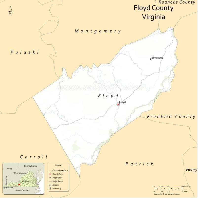
About Floyd County Map, Alabama: The map showing the county boundary, county seat, major cities, highways, water bodies and neighbouring counties.
Related Virginia Links
| Virginia Map | Counties in Virginia | Cities in Virginia |
| Airports in Virginia | Zip Codes in Virginia | Where is Virginia |
| Where is Richmond | Where is Chesapeake | Where is Virginia Beach |
Map of Floyd County, Virginia
Adams County is a county located in the U.S. state of Washington. It`s county seat is Ritzville. As per 2020 census, the population of Adams County was 20613 and population density of Adams was square miles. According to the United States Census Bureau, the county has a total area of 1,925 sq mi (4,986 km2). Adams County was established on 1883.
Floyd County Facts
| Continent | North America |
| Country | United States |
| State | Virginia |
| County Seat | Floyd |
| Largest City/Town | Floyd |
| Established | 1831 |
| Total Area | 382 sq mi (989 sq km) |
| Land Area | 381 sq mi (987 sq km) |
| Water Area | 1 sq mi (2 sq km) |
| Population | 15,279 (Census 2020) |
| Population Density | 40 people per sq mi |
| Time Zone | Eastern (EST) |
| Major Highways | US-221, VA-8 |
| Major Rivers | Little River |
| Neighboring Counties | Montgomery County, Roanoke County, Patrick County, Carroll County, Franklin County, Pulaski County |
| Famous For | Blue Ridge Mountains, music heritage, rural culture |
| Top Attractions | Blue Ridge Parkway, Floyd Country Store, Mabry Mill |
| Official Website | Official Website |
About Floyd County, Virginia
Floyd County is located in the southwestern part of Virginia in the state of the United States, and was established in 1831. The county seat is Floyd, which is also the largest town. The county lies in the Blue Ridge Mountains and is known for its scenic beauty, vibrant music scene, and strong Appalachian culture.
Cities and Towns in Floyd County, Virginia
| City/Town | Population (Census 2020) | Latitude & Longitude |
|---|---|---|
| Floyd (county seat) | 425 | 36.9101°N, 80.3201°W |
| Check (CDP) | 500 | 37.0000°N, 80.3000°W |
| Willis (CDP) | 1,000 | 36.8700°N, 80.4800°W |
| Indian Valley (CDP) | 200 | 36.8900°N, 80.5500°W |
| Alum Ridge (CDP) | 200 | 36.9700°N, 80.4700°W |
| Copper Hill (CDP) | 1,000 | 37.0000°N, 80.2100°W |
Golf Courses in Floyd County, Virginia
| Golf Course | Location | Latitude & Longitude |
|---|---|---|
| No major golf courses within county limits | N/A | N/A |
| Auburn Hills Golf Club (nearby) | Riner area | 37.0500°N, 80.4300°W |
Roads and Highways in Floyd County, Virginia
The county is connected by scenic mountain roads.
- US-221 – main route through the county
- VA-8 – connects Floyd to surrounding regions
Neighboring Counties of Floyd County
- Montgomery County (north)
- Roanoke County (northeast)
- Franklin County (east)
- Patrick County (south)
- Carroll County (southwest)
- Pulaski County (west)
Top Attractions in Floyd County, Virginia
The county offers scenic beauty and cultural experiences.
- Blue Ridge Parkway – scenic drive with overlooks and hiking
- Floyd Country Store – live music and Appalachian culture
- Mabry Mill – historic gristmill and popular landmark
- Buffalo Mountain Natural Area Preserve – hiking and nature
- Rock Castle Gorge – hiking trail with scenic views
- Local artisan shops – crafts, music, and local goods
Distance from Floyd County to Nearby Cities
- Floyd to Roanoke, VA – 30 mi (48 km)
- Floyd to Blacksburg, VA – 25 mi (40 km)
- Floyd to Christiansburg, VA – 20 mi (32 km)
- Floyd to Greensboro, NC – 100 mi (161 km)
- Floyd to Richmond, VA – 200 mi (322 km)
FAQs about Floyd County
Floyd County is located in southwestern Virginia within the Blue Ridge Mountains.
The population of Floyd County is 15,279 according to the 2020 Census.
The county is known for its music heritage, scenic landscapes, and Appalachian culture.
The main highways include US-221 and Virginia Route 8.
No major golf courses are located within Floyd County, but nearby areas offer golf facilities.
- Accomack County Map, VA
- Albemarle County Map, VA
- Alleghany County Map, VA
- Amelia County Map, VA
- Amherst County Map, VA
- Appomattox County Map, VA
- Arlington County Map, VA
- Augusta County Map, VA
- Bath County Map, VA
- Bedford County Map, VA
- Bland County Map, VA
- Botetourt County Map, VA
- Brunswick County Map, VA
- Buchanan County Map, VA
- Buckingham County Map, VA
- Campbell County Map, VA
- Caroline County Map, VA
- Carroll County Map, VA
- Charles City County Map, VA
- Charlotte County Map, VA
- Chesterfield County Map, VA
- Clarke County Map, VA
- Craig County Map, VA
- Culpeper County Map, VA
- Cumberland County Map, VA
- Dickenson County Map, VA
- Dinwiddie County Map, VA
- Essex County Map, VA
- Fairfax County Map, VA
- Fauquier County Map, VA
- Floyd County Map, VA
- Fluvanna County Map, VA
- Franklin County Map, VA
- Frederick County Map, VA
- Giles County Map, VA
- Gloucester County Map, VA
- Goochland County Map, VA
- Grayson County Map, VA
- Greene County Map, VA
- Greensville County Map, VA
- Halifax County Map, VA
- Hanover County Map, VA
- Henrico County Map, VA
- Henry County Map, VA
- Highland County Map, VA
- Isle of Wight County Map, VA
- James City County Map, VA
- King and Queen County Map, VA
- King George County Map, VA
- King William County Map, VA
- Lancaster County Map, VA
- Lee County Map, VA
- Loudoun County Map, VA
- Louisa County Map, VA
- Lunenburg County Map, VA
- Madison County Map, VA
- Mathews County Map, VA
- Mecklenburg County Map, VA
- Middlesex County Map, VA
- Montgomery County Map, VA
- Nelson County Map, VA
- New Kent County Map, VA
- Northampton County Map, VA
- Northumberland County Map, VA
- Nottoway County Map, VA
- Orange County Map, VA
- Page County Map, VA
- Patrick County Map, VA
- Pittsylvania County Map, VA
- Powhatan County Map, VA
- Prince Edward County Map, VA
- Prince George County Map, VA
- Prince William County Map, VA
- Pulaski County Map, VA
- Rappahannock County Map, VA
- Richmond County Map, VA
- Roanoke County Map, VA
- Rockbridge County Map, VA
- Rockingham County Map, VA
- Russell County Map, VA
- Scott County Map, VA
- Shenandoah County Map, VA
- Smyth County Map, VA
- Southampton County Map, VA
- Spotsylvania County Map, VA
- Stafford County Map, VA
- Surry County Map, VA
- Sussex County Map, VA
- Tazewell County Map, VA
- Warren County Map, VA
- Washington County Map, VA
- Westmoreland County Map, VA
- Wise County Map, VA
- Wythe County Map, VA
- York County Map, VA
- Alexandria County Map, VA
- Bristol County Map, VA
- Buena Vista County Map, VA
- Charlottesville County Map, VA
- Chesapeake County Map, VA
- Colonial Heights County Map, VA
- Covington County Map, VA
- Danville County Map, VA
- Emporia County Map, VA
- Fairfax County Map, VA
- Falls Church County Map, VA
- Alabama Counties
- Alaska boroughs
- Arizona Counties
- Arkansas Counties
- California County Map
- Colorado Counties
- Connecticut Counties
- Delaware Counties
- Florida County Map
- Georgia County Map
- Hawaii Counties
- Idaho Counties
- Illinois Counties
- Indiana Counties
- Iowa Counties
- Kansas Counties
- Kentucky Counties
- Louisiana Counties
- Maine Counties
- Maryland Counties
- Massachusetts Counties
- Michigan County Map
- Minnesota Counties
- Mississippi Counties
- Missouri Counties
- Montana Counties
- Nebraska Counties
- Nevada Counties
- New York Counties
- New Hampshire Counties
- New Jersey Counties
- New Mexico Counties
- North Carolina Counties
- North Dakota Counties
- Ohio County Map
- Oklahoma Counties
- Oregon Counties
- Pennsylvania Counties
- Rhode Island Counties
- South Carolina Counties
- South Dakota Counties
- Map of Tennessee
- Texas County Map
- Utah Counties
- Vermont Counties
- Virginia Counties
- Washington Counties
- West Virginia Counties
- Wisconsin Counties
- Wyoming Counties