Map of Accomack County - Accomack County is a county located in the U.S. state of Virginia. Accomack County Map showing cities, highways, important places and water bodies. Get Where is Accomack County located in the map, major cities in Accomack county, population, areas, and places of interest.
Map of Accomack County, Virginia
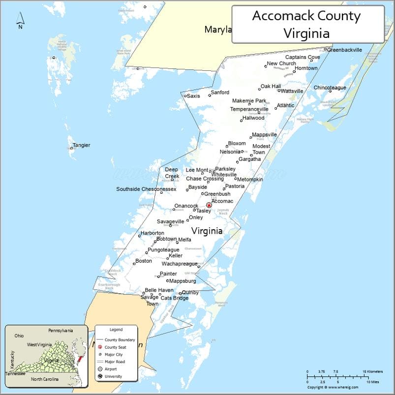
About Accomack County Map, Alabama: The map showing the county boundary, county seat, major cities, highways, water bodies and neighbouring counties.
Related Virginia Links
| Virginia Map | Counties in Virginia | Cities in Virginia |
| Airports in Virginia | Zip Codes in Virginia | Where is Virginia |
| Where is Richmond | Where is Chesapeake | Where is Virginia Beach |
Map of Accomack County, Virginia
Colonial Heights County is a county located in the U.S. state of Virginia. It`s county seat is N/A. As per 2020 census, the population of Colonial Heights County was 18273 and population density of Colonial Heights was square miles. According to the United States Census Bureau, the county has a total area of 8 sq mi (21 km2). Colonial Heights County was established on 1948.
Accomack County Facts
| Continent | North America |
| Country | United States |
| State | Virginia |
| County Seat | Accomac |
| Largest City/Town | Chincoteague |
| Established | 1663 |
| Total Area | 1,310 sq mi (3,393 sq km) |
| Land Area | 450 sq mi (1,166 sq km) |
| Water Area | 860 sq mi (2,227 sq km) |
| Population | 33,413 (Census 2020) |
| Population Density | 74 people per sq mi |
| Time Zone | Eastern (EST) |
| Major Highways | US-13, US-113, SR-175 |
| Major Rivers | Pocomoke River, Atlantic coastal waterways |
| Neighboring Counties | Northampton County (VA), Worcester County (MD), Somerset County (MD) |
| Famous For | Chincoteague ponies, coastal wildlife, seafood industry |
| Top Attractions | Chincoteague National Wildlife Refuge, Assateague Island, NASA Wallops Flight Facility |
| Official Website | Official Website |
About Accomack County, Virginia
Accomack County is located in the eastern part of Virginia on the Delmarva Peninsula, in the state of the United States, and was established in 1663. The county seat is Accomac, which serves as the administrative center, while Chincoteague is the largest town. The area is known for its coastal plains, barrier islands, and strong connection to fishing, agriculture, and space research activities.
Cities and Towns in Accomack County, Virginia
| City/Town | Population (Census 2020) | Latitude & Longitude |
|---|---|---|
| Accomac (county seat) | 519 | 37.7198°N, 75.6683°W |
| Chincoteague | 2,941 | 37.9343°N, 75.3788°W |
| Onancock | 1,263 | 37.7115°N, 75.7499°W |
| Onley | 516 | 37.6926°N, 75.7199°W |
| Parksley | 842 | 37.7835°N, 75.6446°W |
| Saxis | 241 | 37.9226°N, 75.7266°W |
| Tasley | 300 | 37.7018°N, 75.6977°W |
| Wachapreague | 244 | 37.6076°N, 75.6888°W |
| Bloxom | 379 | 37.8290°N, 75.6249°W |
| Greenbackville | 208 | 38.0040°N, 75.3949°W |
| Keller | 178 | 37.6185°N, 75.7550°W |
| Melfa | 450 | 37.6424°N, 75.7424°W |
| New Church | 205 | 37.9826°N, 75.5335°W |
| Painter | 229 | 37.5826°N, 75.8155°W |
| Hallwood | 206 | 37.8715°N, 75.6035°W |
| Horntown | 65 | 37.9721°N, 75.4685°W |
| Captains Cove (CDP) | 1,422 | 37.9923°N, 75.4176°W |
| Temperanceville (CDP) | 350 | 37.8957°N, 75.5652°W |
| Oak Hall (CDP) | 255 | 37.9282°N, 75.5457°W |
| Atlantic (CDP) | 159 | 37.8896°N, 75.5069°W |
Golf Courses in Accomack County, Virginia
| Golf Course | Location | Latitude & Longitude |
|---|---|---|
| Eagle’s Landing Golf Course | Ocean View area / near Chincoteague | 37.9932°N, 75.4145°W |
| Captain's Cove Golf Club | Greenbackville | 37.9895°N, 75.4180°W |
Roads and Highways in Accomack County, Virginia
The county is primarily served by a north-south highway corridor along the Eastern Shore.
- US-13 – main north-south route connecting to Maryland and southern Virginia
- US-113 – northern route connecting toward Delaware
- SR-175 – connects mainland to Chincoteague Island
Neighboring Counties of Accomack County
- Northampton County (south)
- Worcester County, Maryland (north)
- Somerset County, Maryland (northwest)
Top Attractions in Accomack County, Virginia
The county offers a mix of natural beauty, wildlife, and coastal experiences.
- Chincoteague National Wildlife Refuge – famous for wild ponies and birdwatching
- Assateague Island National Seashore – pristine beaches and coastal dunes
- NASA Wallops Flight Facility – active rocket launch site with visitor center
- Historic Onancock Wharf – charming harbor with shops and views
- Ker Place Museum – local history museum in Onancock
- Wachapreague Barrier Islands – gateway to untouched coastal islands
- Saxis Island – quiet fishing village with scenic marsh views
- Eastern Shore Railway Museum – showcases regional rail history
Distance from Accomack County to Nearby Cities
- Accomac to Salisbury, MD – 34 mi (55 km)
- Accomac to Norfolk, VA – 75 mi (121 km)
- Accomac to Virginia Beach, VA – 80 mi (129 km)
- Accomac to Richmond, VA – 150 mi (241 km)
- Accomac to Washington, DC – 140 mi (225 km)
FAQs about Accomack County
Accomack County is located on the Eastern Shore of Virginia along the Atlantic coast, forming part of the Delmarva Peninsula.
The population of Accomack County is 33,413 according to the 2020 Census.
The county is best known for Chincoteague ponies, seafood harvesting, coastal wildlife refuges, and NASA’s Wallops Flight Facility.
The main highways include US-13, US-113, and State Route 175.
Yes, the county has golf facilities such as Captain’s Cove Golf Club and Eagle’s Landing Golf Course.
- Accomack County Map, VA
- Albemarle County Map, VA
- Alleghany County Map, VA
- Amelia County Map, VA
- Amherst County Map, VA
- Appomattox County Map, VA
- Arlington County Map, VA
- Augusta County Map, VA
- Bath County Map, VA
- Bedford County Map, VA
- Bland County Map, VA
- Botetourt County Map, VA
- Brunswick County Map, VA
- Buchanan County Map, VA
- Buckingham County Map, VA
- Campbell County Map, VA
- Caroline County Map, VA
- Carroll County Map, VA
- Charles City County Map, VA
- Charlotte County Map, VA
- Chesterfield County Map, VA
- Clarke County Map, VA
- Craig County Map, VA
- Culpeper County Map, VA
- Cumberland County Map, VA
- Dickenson County Map, VA
- Dinwiddie County Map, VA
- Essex County Map, VA
- Fairfax County Map, VA
- Fauquier County Map, VA
- Floyd County Map, VA
- Fluvanna County Map, VA
- Franklin County Map, VA
- Frederick County Map, VA
- Giles County Map, VA
- Gloucester County Map, VA
- Goochland County Map, VA
- Grayson County Map, VA
- Greene County Map, VA
- Greensville County Map, VA
- Halifax County Map, VA
- Hanover County Map, VA
- Henrico County Map, VA
- Henry County Map, VA
- Highland County Map, VA
- Isle of Wight County Map, VA
- James City County Map, VA
- King and Queen County Map, VA
- King George County Map, VA
- King William County Map, VA
- Lancaster County Map, VA
- Lee County Map, VA
- Loudoun County Map, VA
- Louisa County Map, VA
- Lunenburg County Map, VA
- Madison County Map, VA
- Mathews County Map, VA
- Mecklenburg County Map, VA
- Middlesex County Map, VA
- Montgomery County Map, VA
- Nelson County Map, VA
- New Kent County Map, VA
- Northampton County Map, VA
- Northumberland County Map, VA
- Nottoway County Map, VA
- Orange County Map, VA
- Page County Map, VA
- Patrick County Map, VA
- Pittsylvania County Map, VA
- Powhatan County Map, VA
- Prince Edward County Map, VA
- Prince George County Map, VA
- Prince William County Map, VA
- Pulaski County Map, VA
- Rappahannock County Map, VA
- Richmond County Map, VA
- Roanoke County Map, VA
- Rockbridge County Map, VA
- Rockingham County Map, VA
- Russell County Map, VA
- Scott County Map, VA
- Shenandoah County Map, VA
- Smyth County Map, VA
- Southampton County Map, VA
- Spotsylvania County Map, VA
- Stafford County Map, VA
- Surry County Map, VA
- Sussex County Map, VA
- Tazewell County Map, VA
- Warren County Map, VA
- Washington County Map, VA
- Westmoreland County Map, VA
- Wise County Map, VA
- Wythe County Map, VA
- York County Map, VA
- Alexandria County Map, VA
- Bristol County Map, VA
- Buena Vista County Map, VA
- Charlottesville County Map, VA
- Chesapeake County Map, VA
- Colonial Heights County Map, VA
- Covington County Map, VA
- Danville County Map, VA
- Emporia County Map, VA
- Fairfax County Map, VA
- Falls Church County Map, VA
- Alabama Counties
- Alaska boroughs
- Arizona Counties
- Arkansas Counties
- California County Map
- Colorado Counties
- Connecticut Counties
- Delaware Counties
- Florida County Map
- Georgia County Map
- Hawaii Counties
- Idaho Counties
- Illinois Counties
- Indiana Counties
- Iowa Counties
- Kansas Counties
- Kentucky Counties
- Louisiana Counties
- Maine Counties
- Maryland Counties
- Massachusetts Counties
- Michigan County Map
- Minnesota Counties
- Mississippi Counties
- Missouri Counties
- Montana Counties
- Nebraska Counties
- Nevada Counties
- New York Counties
- New Hampshire Counties
- New Jersey Counties
- New Mexico Counties
- North Carolina Counties
- North Dakota Counties
- Ohio County Map
- Oklahoma Counties
- Oregon Counties
- Pennsylvania Counties
- Rhode Island Counties
- South Carolina Counties
- South Dakota Counties
- Map of Tennessee
- Texas County Map
- Utah Counties
- Vermont Counties
- Virginia Counties
- Washington Counties
- West Virginia Counties
- Wisconsin Counties
- Wyoming Counties