Map of Arlington County - Arlington County is a county located in the U.S. state of Virginia. Arlington County Map showing cities, highways, important places and water bodies. Get Where is Arlington County located in the map, major cities in Arlington county, population, areas, and places of interest.
Map of Arlington County, Virginia
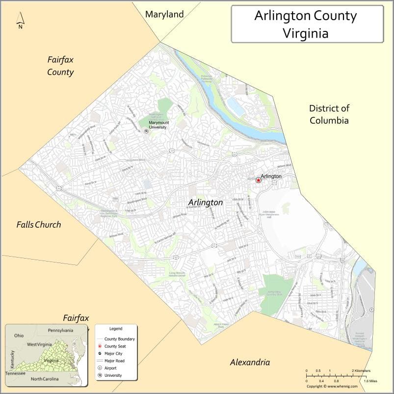
About Arlington County Map, Alabama: The map showing the county boundary, county seat, major cities, highways, water bodies and neighbouring counties.
Related Virginia Links
| Virginia Map | Counties in Virginia | Cities in Virginia |
| Airports in Virginia | Zip Codes in Virginia | Where is Virginia |
| Where is Richmond | Where is Chesapeake | Where is Virginia Beach |
Map of Arlington County, Virginia
Franklin County is a county located in the U.S. state of Virginia. It`s county seat is N/A. As per 2020 census, the population of Franklin County was 8217 and population density of Franklin was square miles. According to the United States Census Bureau, the county has a total area of 8 sq mi (21 km2). Franklin County was established on 1961.
Arlington County Facts
| Continent | North America |
| Country | United States |
| State | Virginia |
| County Seat | None (independent county) |
| Largest City/Town | Arlington |
| Established | 1920 (renamed from Alexandria County) |
| Total Area | 26 sq mi (67 sq km) |
| Land Area | 26 sq mi (67 sq km) |
| Water Area | 0.2 sq mi (0.5 sq km) |
| Population | 238,643 (Census 2020) |
| Population Density | 9,180 people per sq mi |
| Time Zone | Eastern (EST) |
| Major Highways | I-66, I-395, US-1, George Washington Parkway |
| Major Rivers | Potomac River |
| Neighboring Counties | Fairfax County (VA), Alexandria (VA), Washington, DC |
| Famous For | Arlington National Cemetery, Pentagon, proximity to Washington, DC |
| Top Attractions | Arlington National Cemetery, Pentagon Memorial, Theodore Roosevelt Island |
| Official Website | Official Website |
About Arlington County, Virginia
Arlington County is located in the northern part of Virginia across the Potomac River from Washington, DC, in the state of the United States, and was established in 1920 when it was renamed from Alexandria County. The county does not have a traditional county seat and functions as a unified urban jurisdiction. It is one of the most densely populated counties in the country and serves as a key hub for government, military, and business activities.
Cities and Towns in Arlington County, Virginia
| City/Town | Population (Census 2020) | Latitude & Longitude |
|---|---|---|
| Arlington (countywide) | 238,643 | 38.8816°N, 77.0910°W |
| Rosslyn (CDP) | 15,000 | 38.8951°N, 77.0720°W |
| Crystal City (CDP) | 22,000 | 38.8557°N, 77.0490°W |
| Ballston (CDP) | 20,000 | 38.8806°N, 77.1114°W |
| Shirlington (CDP) | 10,000 | 38.8423°N, 77.0872°W |
Golf Courses in Arlington County, Virginia
| Golf Course | Location | Latitude & Longitude |
|---|---|---|
| Army Navy Country Club | Arlington | 38.8710°N, 77.0835°W |
| Washington Golf & Country Club | Arlington | 38.9103°N, 77.1215°W |
| East Potomac Golf Links (nearby) | Washington, DC | 38.8729°N, 77.0219°W |
Roads and Highways in Arlington County, Virginia
The county is highly connected with major highways serving the Washington metropolitan area.
- I-66 – east-west route connecting Arlington to Washington, DC and Northern Virginia
- I-395 – major corridor linking Arlington to Alexandria and Washington, DC
- US-1 – runs along the Potomac River through the county
- George Washington Parkway – scenic route along the river
Neighboring Counties of Arlington County
- Fairfax County (west and south)
- Alexandria (south)
- Washington, DC (east)
Top Attractions in Arlington County, Virginia
The county is home to major national landmarks and memorials.
- Arlington National Cemetery – burial site of U.S. service members and national figures
- The Pentagon – headquarters of the U.S. Department of Defense
- Pentagon Memorial – tribute to 9/11 victims
- Theodore Roosevelt Island – natural memorial and park
- US Marine Corps War Memorial – iconic Iwo Jima statue
- Gravelly Point Park – popular spot for plane watching
- Air Force Memorial – distinctive spire-like monument
Distance from Arlington County to Nearby Cities
- Arlington to Washington, DC – 5 mi (8 km)
- Arlington to Alexandria, VA – 6 mi (10 km)
- Arlington to Fairfax, VA – 20 mi (32 km)
- Arlington to Baltimore, MD – 40 mi (64 km)
- Arlington to Richmond, VA – 105 mi (169 km)
FAQs about Arlington County
Arlington County is located in northern Virginia directly across the Potomac River from Washington, DC.
The population of Arlington County is 238,643 according to the 2020 Census.
The county is known for Arlington National Cemetery, the Pentagon, and its close connection to Washington, DC.
The main highways include I-66, I-395, US-1, and the George Washington Parkway.
Yes, Arlington County has golf facilities such as Army Navy Country Club and Washington Golf & Country Club.
- Accomack County Map, VA
- Albemarle County Map, VA
- Alleghany County Map, VA
- Amelia County Map, VA
- Amherst County Map, VA
- Appomattox County Map, VA
- Arlington County Map, VA
- Augusta County Map, VA
- Bath County Map, VA
- Bedford County Map, VA
- Bland County Map, VA
- Botetourt County Map, VA
- Brunswick County Map, VA
- Buchanan County Map, VA
- Buckingham County Map, VA
- Campbell County Map, VA
- Caroline County Map, VA
- Carroll County Map, VA
- Charles City County Map, VA
- Charlotte County Map, VA
- Chesterfield County Map, VA
- Clarke County Map, VA
- Craig County Map, VA
- Culpeper County Map, VA
- Cumberland County Map, VA
- Dickenson County Map, VA
- Dinwiddie County Map, VA
- Essex County Map, VA
- Fairfax County Map, VA
- Fauquier County Map, VA
- Floyd County Map, VA
- Fluvanna County Map, VA
- Franklin County Map, VA
- Frederick County Map, VA
- Giles County Map, VA
- Gloucester County Map, VA
- Goochland County Map, VA
- Grayson County Map, VA
- Greene County Map, VA
- Greensville County Map, VA
- Halifax County Map, VA
- Hanover County Map, VA
- Henrico County Map, VA
- Henry County Map, VA
- Highland County Map, VA
- Isle of Wight County Map, VA
- James City County Map, VA
- King and Queen County Map, VA
- King George County Map, VA
- King William County Map, VA
- Lancaster County Map, VA
- Lee County Map, VA
- Loudoun County Map, VA
- Louisa County Map, VA
- Lunenburg County Map, VA
- Madison County Map, VA
- Mathews County Map, VA
- Mecklenburg County Map, VA
- Middlesex County Map, VA
- Montgomery County Map, VA
- Nelson County Map, VA
- New Kent County Map, VA
- Northampton County Map, VA
- Northumberland County Map, VA
- Nottoway County Map, VA
- Orange County Map, VA
- Page County Map, VA
- Patrick County Map, VA
- Pittsylvania County Map, VA
- Powhatan County Map, VA
- Prince Edward County Map, VA
- Prince George County Map, VA
- Prince William County Map, VA
- Pulaski County Map, VA
- Rappahannock County Map, VA
- Richmond County Map, VA
- Roanoke County Map, VA
- Rockbridge County Map, VA
- Rockingham County Map, VA
- Russell County Map, VA
- Scott County Map, VA
- Shenandoah County Map, VA
- Smyth County Map, VA
- Southampton County Map, VA
- Spotsylvania County Map, VA
- Stafford County Map, VA
- Surry County Map, VA
- Sussex County Map, VA
- Tazewell County Map, VA
- Warren County Map, VA
- Washington County Map, VA
- Westmoreland County Map, VA
- Wise County Map, VA
- Wythe County Map, VA
- York County Map, VA
- Alexandria County Map, VA
- Bristol County Map, VA
- Buena Vista County Map, VA
- Charlottesville County Map, VA
- Chesapeake County Map, VA
- Colonial Heights County Map, VA
- Covington County Map, VA
- Danville County Map, VA
- Emporia County Map, VA
- Fairfax County Map, VA
- Falls Church County Map, VA
- Alabama Counties
- Alaska boroughs
- Arizona Counties
- Arkansas Counties
- California County Map
- Colorado Counties
- Connecticut Counties
- Delaware Counties
- Florida County Map
- Georgia County Map
- Hawaii Counties
- Idaho Counties
- Illinois Counties
- Indiana Counties
- Iowa Counties
- Kansas Counties
- Kentucky Counties
- Louisiana Counties
- Maine Counties
- Maryland Counties
- Massachusetts Counties
- Michigan County Map
- Minnesota Counties
- Mississippi Counties
- Missouri Counties
- Montana Counties
- Nebraska Counties
- Nevada Counties
- New York Counties
- New Hampshire Counties
- New Jersey Counties
- New Mexico Counties
- North Carolina Counties
- North Dakota Counties
- Ohio County Map
- Oklahoma Counties
- Oregon Counties
- Pennsylvania Counties
- Rhode Island Counties
- South Carolina Counties
- South Dakota Counties
- Map of Tennessee
- Texas County Map
- Utah Counties
- Vermont Counties
- Virginia Counties
- Washington Counties
- West Virginia Counties
- Wisconsin Counties
- Wyoming Counties