Map of Caroline County - Caroline County is a county located in the U.S. state of Virginia. Caroline County Map showing cities, highways, important places and water bodies. Get Where is Caroline County located in the map, major cities in Caroline county, population, areas, and places of interest.
Map of Caroline County, Virginia
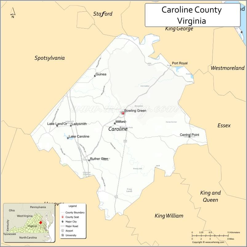
About Caroline County Map, Alabama: The map showing the county boundary, county seat, major cities, highways, water bodies and neighbouring counties.
Related Virginia Links
| Virginia Map | Counties in Virginia | Cities in Virginia |
| Airports in Virginia | Zip Codes in Virginia | Where is Virginia |
| Where is Richmond | Where is Chesapeake | Where is Virginia Beach |
Map of Caroline County, Virginia
Martinsville County is a county located in the U.S. state of Virginia. It`s county seat is N/A. As per 2020 census, the population of Martinsville County was 13517 and population density of Martinsville was square miles. According to the United States Census Bureau, the county has a total area of 11 sq mi (28 km2). Martinsville County was established on 1928.
Caroline County Facts
| Continent | North America |
| Country | United States |
| State | Virginia |
| County Seat | Bowling Green |
| Largest City/Town | Ladysmith |
| Established | 1728 |
| Total Area | 537 sq mi (1,391 sq km) |
| Land Area | 528 sq mi (1,367 sq km) |
| Water Area | 9 sq mi (24 sq km) |
| Population | 30,887 (Census 2020) |
| Population Density | 58 people per sq mi |
| Time Zone | Eastern (EST) |
| Major Highways | I-95, US-1, US-301 |
| Major Rivers | Rappahannock River, Mattaponi River |
| Neighboring Counties | Spotsylvania County, King George County, Essex County, King and Queen County, Hanover County |
| Famous For | Birthplace of James Madison, Civil War history, rural landscapes |
| Top Attractions | Meadow Farm Museum, Fort A.P. Hill, Caroline County Courthouse |
| Official Website | Official Website |
About Caroline County, Virginia
Caroline County is located in the eastern-central part of Virginia in the state of the United States, and was established in 1728. The county seat is Bowling Green, while Ladysmith is the largest community. The county lies between Richmond and Fredericksburg and features a mix of rural farmland, forests, and historic sites tied to early American history.
Cities and Towns in Caroline County, Virginia
| City/Town | Population (Census 2020) | Latitude & Longitude |
|---|---|---|
| Bowling Green (county seat) | 1,178 | 38.0496°N, 77.3469°W |
| Port Royal (town) | 126 | 38.1701°N, 77.1883°W |
| Ladysmith (CDP) | 7,000 | 38.0301°N, 77.5183°W |
| Ruther Glen (CDP) | 3,000 | 37.9560°N, 77.4780°W |
| Woodford (CDP) | 1,000 | 38.0845°N, 77.3041°W |
| Milford (CDP) | 500 | 38.0365°N, 77.2503°W |
| Corbin (CDP) | 300 | 37.9976°N, 77.3700°W |
| Bowling Green (CDP) | 1,200 | 38.0496°N, 77.3469°W |
Golf Courses in Caroline County, Virginia
| Golf Course | Location | Latitude & Longitude |
|---|---|---|
| Pendleton Golf Club | Ruther Glen | 37.9505°N, 77.4885°W |
| Mattaponi Springs Golf Club | Ruther Glen | 37.9335°N, 77.4685°W |
Roads and Highways in Caroline County, Virginia
The county is a major transportation corridor between Richmond and Northern Virginia.
- I-95 – major north-south interstate connecting Richmond and Washington, DC
- US-1 – historic highway running parallel to I-95
- US-301 – connects the county to Maryland and southeastern Virginia
Neighboring Counties of Caroline County
- Spotsylvania County (north)
- King George County (northeast)
- Essex County (east)
- King and Queen County (southeast)
- Hanover County (south)
Top Attractions in Caroline County, Virginia
The county features historic landmarks and outdoor spaces.
- Fort A.P. Hill – large U.S. Army training facility with historical significance
- Port Royal Historic District – colonial-era town along the Rappahannock River
- Caroline County Courthouse – historic government building
- Meadow Event Park (nearby) – event venue and birthplace of Secretariat
- Mattaponi River – fishing and outdoor recreation
- Virginia Sports Complex – local sports and recreation facility
Distance from Caroline County to Nearby Cities
- Bowling Green to Fredericksburg, VA – 20 mi (32 km)
- Bowling Green to Richmond, VA – 45 mi (72 km)
- Bowling Green to Washington, DC – 75 mi (121 km)
- Bowling Green to Williamsburg, VA – 85 mi (137 km)
- Bowling Green to Norfolk, VA – 110 mi (177 km)
FAQs about Caroline County
Caroline County is located in eastern-central Virginia between Richmond and Fredericksburg.
The population of Caroline County is 30,887 according to the 2020 Census.
The county is known for its historical sites, including connections to James Madison and Civil War history.
The main highways include Interstate 95, US-1, and US-301.
Yes, Caroline County has golf courses such as Pendleton Golf Club and Mattaponi Springs Golf Club.
- Accomack County Map, VA
- Albemarle County Map, VA
- Alleghany County Map, VA
- Amelia County Map, VA
- Amherst County Map, VA
- Appomattox County Map, VA
- Arlington County Map, VA
- Augusta County Map, VA
- Bath County Map, VA
- Bedford County Map, VA
- Bland County Map, VA
- Botetourt County Map, VA
- Brunswick County Map, VA
- Buchanan County Map, VA
- Buckingham County Map, VA
- Campbell County Map, VA
- Caroline County Map, VA
- Carroll County Map, VA
- Charles City County Map, VA
- Charlotte County Map, VA
- Chesterfield County Map, VA
- Clarke County Map, VA
- Craig County Map, VA
- Culpeper County Map, VA
- Cumberland County Map, VA
- Dickenson County Map, VA
- Dinwiddie County Map, VA
- Essex County Map, VA
- Fairfax County Map, VA
- Fauquier County Map, VA
- Floyd County Map, VA
- Fluvanna County Map, VA
- Franklin County Map, VA
- Frederick County Map, VA
- Giles County Map, VA
- Gloucester County Map, VA
- Goochland County Map, VA
- Grayson County Map, VA
- Greene County Map, VA
- Greensville County Map, VA
- Halifax County Map, VA
- Hanover County Map, VA
- Henrico County Map, VA
- Henry County Map, VA
- Highland County Map, VA
- Isle of Wight County Map, VA
- James City County Map, VA
- King and Queen County Map, VA
- King George County Map, VA
- King William County Map, VA
- Lancaster County Map, VA
- Lee County Map, VA
- Loudoun County Map, VA
- Louisa County Map, VA
- Lunenburg County Map, VA
- Madison County Map, VA
- Mathews County Map, VA
- Mecklenburg County Map, VA
- Middlesex County Map, VA
- Montgomery County Map, VA
- Nelson County Map, VA
- New Kent County Map, VA
- Northampton County Map, VA
- Northumberland County Map, VA
- Nottoway County Map, VA
- Orange County Map, VA
- Page County Map, VA
- Patrick County Map, VA
- Pittsylvania County Map, VA
- Powhatan County Map, VA
- Prince Edward County Map, VA
- Prince George County Map, VA
- Prince William County Map, VA
- Pulaski County Map, VA
- Rappahannock County Map, VA
- Richmond County Map, VA
- Roanoke County Map, VA
- Rockbridge County Map, VA
- Rockingham County Map, VA
- Russell County Map, VA
- Scott County Map, VA
- Shenandoah County Map, VA
- Smyth County Map, VA
- Southampton County Map, VA
- Spotsylvania County Map, VA
- Stafford County Map, VA
- Surry County Map, VA
- Sussex County Map, VA
- Tazewell County Map, VA
- Warren County Map, VA
- Washington County Map, VA
- Westmoreland County Map, VA
- Wise County Map, VA
- Wythe County Map, VA
- York County Map, VA
- Alexandria County Map, VA
- Bristol County Map, VA
- Buena Vista County Map, VA
- Charlottesville County Map, VA
- Chesapeake County Map, VA
- Colonial Heights County Map, VA
- Covington County Map, VA
- Danville County Map, VA
- Emporia County Map, VA
- Fairfax County Map, VA
- Falls Church County Map, VA
- Alabama Counties
- Alaska boroughs
- Arizona Counties
- Arkansas Counties
- California County Map
- Colorado Counties
- Connecticut Counties
- Delaware Counties
- Florida County Map
- Georgia County Map
- Hawaii Counties
- Idaho Counties
- Illinois Counties
- Indiana Counties
- Iowa Counties
- Kansas Counties
- Kentucky Counties
- Louisiana Counties
- Maine Counties
- Maryland Counties
- Massachusetts Counties
- Michigan County Map
- Minnesota Counties
- Mississippi Counties
- Missouri Counties
- Montana Counties
- Nebraska Counties
- Nevada Counties
- New York Counties
- New Hampshire Counties
- New Jersey Counties
- New Mexico Counties
- North Carolina Counties
- North Dakota Counties
- Ohio County Map
- Oklahoma Counties
- Oregon Counties
- Pennsylvania Counties
- Rhode Island Counties
- South Carolina Counties
- South Dakota Counties
- Map of Tennessee
- Texas County Map
- Utah Counties
- Vermont Counties
- Virginia Counties
- Washington Counties
- West Virginia Counties
- Wisconsin Counties
- Wyoming Counties