
North Bay Village is a small waterfront municipality in southeast Florida, located in Miami-Dade County between Miami and Miami Beach. It sits about 7 miles northeast of downtown Miami and is surrounded by Biscayne Bay. The village is known for its island setting, Kennedy Causeway, waterfront parks, and close access to the beaches, cultural attractions, and urban districts of the Miami area.
Location Map of North Bay Village, Miami-Dade County, Florida
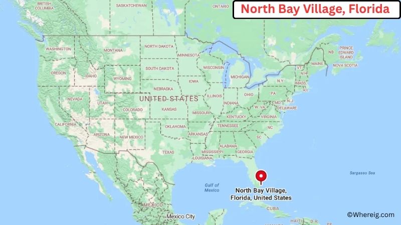
About Map: The map shows the location of North Bay Village in Miami-Dade County, in the U.S. state of Florida.
North Bay Village Map, Florida
About North Bay Village Map: The Google Map highlights the location of North Bay Village in Miami-Dade County, Florida. Use the zoom, satellite, and street-view options to explore the city's neighborhoods, roads, and nearby places.
Where is North Bay Village Located?
North Bay Village is a city located in Miami-Dade County, Florida, the United States. It lies in Biscayne Bay between Miami and Miami Beach, about 7 miles northeast of downtown Miami and roughly 5 miles west of Miami Beach. Miami Shores is about 3 miles north, while Surfside is around 5 miles northeast. North Bay Village is positioned near 25.846° North latitude and 80.153° West longitude. The 2020 Census recorded 8,159 residents. The village covers about 1.5 square miles, or 3.9 square kilometers, of total area, much of which consists of surrounding water. North Bay Village is made up of three main islands connected by the Kennedy Causeway. The waterfront setting is its most distinctive geographic feature, with views across Biscayne Bay toward Miami and Miami Beach. Nearby attractions include Normandy Isle, Miami Beach, and the beaches of Bal Harbour and Surfside. North Bay Village was incorporated in 1945 and developed as a residential community on the bay. A unique fact about the village is that its three-island layout gives it one of the most distinctive waterfront settings among Miami-Dade County municipalities.
Most Viewed US Maps
| USA Sttae Map | USA Region Map | USA Road Map |
| USA County Map | Where is USA in World Map? | US ZIP Code Map |
| USA Time Zones Map | US State and Capitals Map | USA Physical Map |
Find 4,400+ U.S. Cities by State - Explore Their Locations and Get Detailed Information
North Bay Village City Facts
| City | North Bay Village |
| State | Florida |
| County | Miami-Dade County |
| Country | United States |
| Region | South Florida and Miami Metropolitan Area |
| Incorporated | 1945 |
| Founded | 1945 |
| Total Area | 1.5 sq mi (3.9 sq km) |
| Land Area | 0.37 sq mi (0.96 sq km) |
| Water Area | About 1.13 sq mi (2.93 sq km) |
| Elevation | 6 ft (2 m) |
| Population (2023 estimate) | About 8,200 |
| Population (2020 Census) | 8,159 |
| Population Density | 22,051 people per sq mi of land |
| Time Zone | Eastern Time (EST/EDT) |
| ZIP Codes | 33141 |
| Area Code | 305 and 786 |
| Major Highways | US-1, I-95, FL-934, and Kennedy Causeway |
| Public Transit | Miami-Dade Transit |
| Major Attractions | Kennedy Causeway, North Bay Village waterfront, Biscayne Bay, Normandy Isle, Miami Beach, and Bal Harbour |
| Official Website | https://northbayvillage-fl.gov/ |
Distance from North Bay Village, FL to Nearby Cities
- Miami Beach, FL – 5 miles (8 km)
- Miami Shores, FL – 3 miles (5 km)
- Surfside, FL – 5 miles (8 km)
- Miami, FL – 7 miles (11 km)
- Bal Harbour, FL – 6 miles (10 km)
- Bay Harbor Islands, FL – 5 miles (8 km)
- El Portal, FL – 5 miles (8 km)
- North Miami, FL – 7 miles (11 km)
- Hialeah, FL – 12 miles (19 km)
- Coral Gables, FL – 12 miles (19 km)
- South Miami, FL – 15 miles (24 km)
- Miami Gardens, FL – 15 miles (24 km)
- Aventura, FL – 15 miles (24 km)
- Hollywood, FL – 20 miles (32 km)
- Fort Lauderdale, FL – 30 miles (48 km)
- Homestead, FL – 40 miles (64 km)
- Key Biscayne, FL – 12 miles (19 km)
- Weston, FL – 35 miles (56 km)
Top Attractions in North Bay Village, FL
- Kennedy Causeway – The main roadway connecting North Bay Village with Miami and Miami Beach, offering views across Biscayne Bay.
- Biscayne Bay – The bay surrounding the village provides opportunities for boating, fishing, kayaking, and waterfront sightseeing.
- North Bay Village Waterfront – The village's shoreline offers views of Biscayne Bay, Miami's skyline, and nearby islands.
- Normandy Isle – A nearby island community known for its circular street layout, waterfront setting, shops, restaurants, and residential neighborhoods.
- Miami Beach – A nearby coastal city famous for its beaches, Art Deco Historic District, Ocean Drive, and cultural attractions.
- Bal Harbour Beach – A nearby Atlantic Ocean beach area known for its broad sandy shoreline and coastal scenery.
- Haulover Park – A nearby waterfront park offering beaches, boating facilities, picnic areas, fishing, and outdoor recreation.
- Oleta River State Park – A nearby state park with mangrove forests, kayaking, mountain-bike trails, fishing, and wildlife habitat.
Airports Near North Bay Village, FL
- Miami International Airport (MIA) – 12 miles
- Miami-Opa Locka Executive Airport (OPF) – 12 miles
- Fort Lauderdale-Hollywood International Airport (FLL) – 25 miles
- Miami Executive Airport (TMB) – 30 miles
- North Perry Airport (HWO) – 20 miles
Sources:
Population and area data sourced from the United States Census Bureau (2020 Census). General city information referenced from the official North Bay Village website and local government records.
Florida Related Maps and Info
- Where is Miami
- Where is Hialeah
- Where is Jacksonville
- Where is Orlando
- Where is Saint Petersburg
- Where is Tampa
- Where is Alafaya
- Where is Boca Raton
- Where is Boynton Beach
- Where is Brandon
- Where is Cape Coral
- Where is Clearwater
- Where is Coral Springs
- Where is Davie
- Where is Daytona Beach
- Where is Deerfield Beach
- Where is Deltona
- Where is Doral
- Where is Fort Lauderdale
- Where is Fort Myers
- Where is Gainesville
- Where is Hollywood
- Where is Homestead
- Where is Horizon West
- Where is Kendall
- Where is Kissimmee
- Where is Lakeland
- Where is Largo
- Where is Lauderhill
- Where is Lehigh Acres
- Where is Melbourne
- Where is Miami Beach
- Where is Miami Gardens
- Where is Miramar
- Where is North Port
- Where is Palm Bay
- Where is Palm Coast
- Where is Pembroke Pines
- Where is Plantation
- Where is Poinciana
- Where is Pompano Beach
- Where is Port St. Lucie
- Where is Riverview
- Where is Spring Hill
- Where is St. Petersburg
- Where is Sunrise
- Where is Tallahassee
- Where is Tamarac
- Where is The Villages
- Where is Town 'n' Country
- Where is West Palm Beach