
Where is Shively Located? - Shively is a city located in the Jefferson County of Kentucky, United States. Shively lies between 39.5575832 Degrees North latitudes and 76.3984537 Degrees West longitudes.
Location Map of Shively, Kentucky
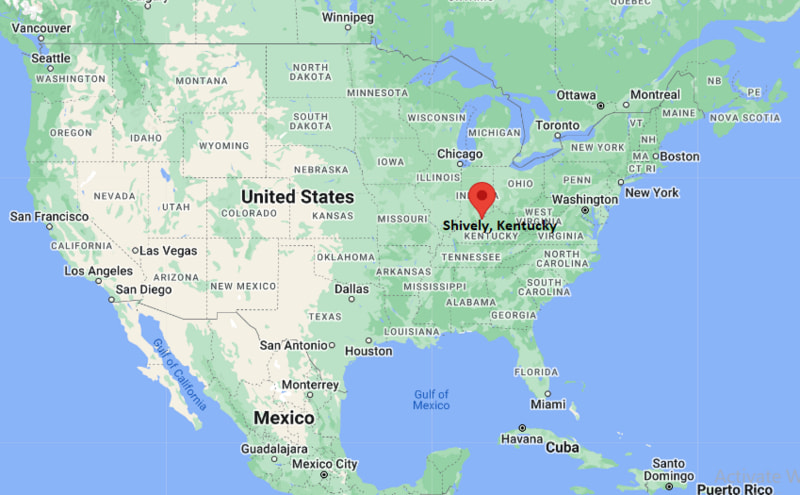
Shively Map, Kentucky, USA
Where is Shively?: The Google Map showing the location of Shively in the U.S. state of Kentucky.
Where is Shively Located?
Shively is a city located in the Jefferson County of Kentucky, United States. Shively lies between 39.5575832 Degrees North latitudes and 76.3984537 Degrees West longitudes. According to 2020 U.S.census, the population of Shively city is 15636 people and the city has a total area of 4.57 sq mi. The city has numerous parks and recreational facilities.
Most Viewed US Maps
| USA Sttae Map | USA Region Map | USA Road Map |
| USA County Map | Where is USA in World Map? | US ZIP Code Map |
| USA Time Zones Map | US State and Capitals Map | USA Physical Map |
Find 4,400+ U.S. Cities by State - Explore Their Locations and Get Detailed Information
Shively, Kentucky Quick Facts
| Attribute | Details |
|---|---|
| City | Shively |
| County | Jefferson County |
| State | Kentucky |
| State Capital | Frankfort |
| US Region | Southern United States |
| Latitude | 38.2001° N |
| Longitude | 85.8080° W |
| Elevation | 476 ft (145 m) |
| Land Area (sq mi) | 3.22 |
| Water Area (sq mi) | 0.00 |
| Total Area (sq mi) | 3.22 |
| Population (2020 Census) | 15,703 |
| Population Density (per sq mi) | 4,876.7 |
| ZIP Codes | 40216 |
| Area Code | 502 |
| Time Zone Standard | Eastern Standard Time (EST), UTC−5 |
| Time Zone Daylight | Eastern Daylight Time (EDT), UTC−4 |
| Currency | United States Dollar (USD) |
| FIPS Code | 2170672 |
| Congressional District | 3rd Congressional District |
Transportation and Connectivity in Shively
| Transportation Feature | Details |
|---|---|
| Airport Name | Louisville Muhammad Ali International Airport provides commercial air service. |
| IATA Code | SDF |
| Port | Ohio River ports in Louisville provide regional shipping access. |
| Major Highways | Interstate 264, Dixie Highway (U.S. 31W), and Interstate 65 nearby |
| Train/Amtrak Service | Amtrak service is available at Louisville Union Station. |
| Local Bus/Transit Service | Transit Authority of River City (TARC) provides bus service throughout the Louisville area. |
- Interstate 264 provides access around the Louisville metropolitan area.
- Dixie Highway connects Shively with Louisville and communities in western Jefferson County.
- Interstate 65 provides regional travel toward Indianapolis, Nashville, and other major cities.
- The city is connected to Louisville’s regional transportation network.
Top Places to Visit in Shively, Kentucky
| Landmark Name | Type |
|---|---|
| Ralph Avenue Park | Park |
| Shively City Park | Park |
| Churchill Downs | Historic Sports Venue |
| Louisville Zoo | Zoo |
| Louisville Mega Cavern | Attraction |
| Speed Art Museum | Museum |
| Waterfront Park | Riverfront Park |
| Frazier History Museum | Museum |
| Ohio River | Natural Attraction |
| Bernheim Forest | Nature Reserve |
Driving Distances from Shively, Kentucky to Nearby Cities
| City | State | Distance (mi) | Approx. Drive Time |
|---|---|---|---|
| Louisville | Kentucky | 5 | 10 min |
| Jeffersontown | Kentucky | 15 | 25 min |
| New Albany | Indiana | 10 | 20 min |
| Elizabethtown | Kentucky | 45 | 50 min |
| Bardstown | Kentucky | 40 | 50 min |
| Frankfort | Kentucky | 60 | 1 hr |
| Lexington | Kentucky | 75 | 1 hr 20 min |
| Cincinnati | Ohio | 100 | 1 hr 40 min |
| Indianapolis | Indiana | 115 | 2 hr |
| Nashville | Tennessee | 180 | 2 hr 45 min |
Colleges and Universities near Shively, Kentucky
| Institution Name | Type | Level | Notable For |
|---|---|---|---|
| University of Louisville | Public | University | Research, medicine, engineering, and professional programs |
| Jefferson Community and Technical College | Public | Community College | Career training and associate degree programs |
| Spalding University | Private | University | Health sciences, education, and liberal arts |
| Bellarmine University | Private | University | Liberal arts and professional education |
Waterbodies in Shively, Kentucky
Ohio River, Mill Creek, Pond Creek, Beargrass Creek, and nearby Louisville waterways
Golf Courses near Shively, Kentucky
Sun Valley Golf Course, Iroquois Golf Course, Seneca Golf Course, Shawnee Golf Course
Key Landmarks and Places to Visit in Shively, Kentucky
| Landmark Name | Type |
|---|---|
| Shively City Park | Park |
| Ralph Avenue Park | Park |
| Churchill Downs | Historic Sports Venue |
| Louisville Zoo | Zoo |
| Louisville Mega Cavern | Attraction |
| Speed Art Museum | Museum |
| Frazier History Museum | Museum |
| Waterfront Park | Riverfront Park |
| Ohio River | Natural Attraction |
| Bernheim Forest | Nature Reserve |
Waterbodies in Shively, Kentucky
Ohio River, Mill Creek, Pond Creek, Beargrass Creek, and nearby Louisville waterways
Golf Courses near Shively, Kentucky
Sun Valley Golf Course, Iroquois Golf Course, Seneca Golf Course, Shawnee Golf Course
Shively, Kentucky — Key Historical Facts
- Shively was incorporated as a city in 1938 and developed as a suburban community west of Louisville.
- The area was originally farmland and gradually transformed into a residential and commercial area during the 20th century.
- Shively grew due to its location along Dixie Highway and its connection to the Louisville metropolitan area.
- The city became known for its neighborhood communities, local businesses, and proximity to major Louisville attractions.
- Shively remains an important suburban city within Jefferson County and the Louisville region.
References
- City of Shively Official Website
- Louisville Metro Government
- U.S. Census Bureau
- Kentucky State Parks
- University of Louisville
- Churchill Downs
Kentucky Related Maps and Info
- Where is Alexandria
- Where is Ashland
- Where is Bardstown
- Where is Berea
- Where is Bowling Green
- Where is Burlington
- Where is Campbellsville
- Where is Covington
- Where is Danville
- Where is Elizabethtown
- Where is Elsmere
- Where is Erlanger
- Where is Florence
- Where is Fort Campbell North
- Where is Fort Thomas
- Where is Francisville
- Where is Frankfort
- Where is Franklin
- Where is Georgetown
- Where is Glasgow
- Where is Harrodsburg
- Where is Hopkinsville
- Where is Independence
- Where is Jeffersontown
- Where is La Grange
- Where is Lawrenceburg
- Where is Lyndon
- Where is Madisonville
- Where is Mayfield
- Where is Middletown
- Where is Mount Washington
- Where is Murray
- Where is Newport
- Where is Nicholasville
- Where is Oakbrook
- Where is Owensboro
- Where is Paducah
- Where is Paris
- Where is Radcliff
- Where is Shelbyville
- Where is Shepherdsville
- Where is Shively
- Where is Somerset
- Where is St. Matthews
- Where is Versailles
- Where is Winchester