Map of Jefferson County - Jefferson County is a county located in the U.S. state of Kentucky. Jefferson County Map showing cities, highways, important places and water bodies. Get Where is Jefferson County located in the map, major cities in Jefferson county, population, areas, and places of interest.
Map of Jefferson County, Kentucky
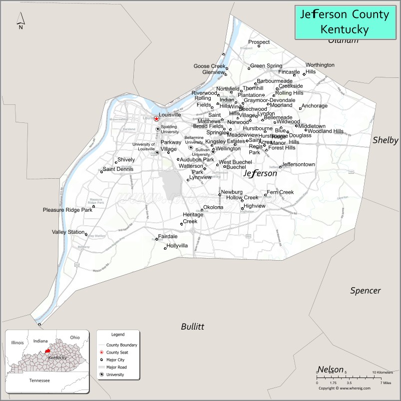
About Jefferson County Map, Kentucky: The map showing the county boundary, county seat, major cities, highways, water bodies and neighbouring counties.
More Kentucky Maps & Info
Map of Jefferson County, Kentucky
Jefferson County is a county located in the U.S. state of Kentucky. It's county seat is Louisville. As per 2020 census, the population of Jefferson County is 777874 people and population density is square miles. According to the United States Census Bureau, the county has a total area of 385 sq mi (997 km2). Jefferson County was established on 1780.
Jefferson County Facts
| Continent | North America |
| Country | United States |
| State | Kentucky |
| County Seat | Louisville |
| Largest City/Town | Louisville |
| Established | 1780 |
| Total Area | 398 sq mi (1,031 sq km) |
| Land Area | 380 sq mi (984 sq km) |
| Water Area | 17 sq mi (44 sq km) |
| Population | 782,969 (Census 2020) |
| Population Density | 2,060 people per sq mi |
| Time Zone | Eastern Time Zone (ET) |
| Major Highways | Interstate 64, Interstate 65, Interstate 71, Interstate 264, Interstate 265, U.S. Route 31W |
| Major Rivers | Ohio River |
| Neighboring Counties | Oldham County, Bullitt County, Shelby County, Spencer County, Clark County (IN), Floyd County (IN), Harrison County (IN) |
| Famous For | Kentucky Derby, bourbon culture, Louisville Slugger, riverfront attractions, and historic architecture |
| Top Attractions | Churchill Downs, Louisville Slugger Museum & Factory, Kentucky Kingdom, Muhammad Ali Center, Waterfront Park |
| Official Website | Official Website |
About Jefferson County, Kentucky
Jefferson County is located in north-central Kentucky along the Ohio River and was established in 1780. The county seat and largest city is Louisville, Kentucky’s largest city. Jefferson County is known for the Kentucky Derby, bourbon distilleries, sports traditions, arts and culture, riverfront development, and its role as a major economic center in the region. ([en.wikipedia.org](https://en.wikipedia.org/wiki/Jefferson_County%2C_Kentucky?utm_source=chatgpt.com))
Cities and Communities in Jefferson County, Kentucky
| City Name | Type | Population (2020) | Pop. Density | Area | Incorporated |
|---|---|---|---|---|---|
| Anchorage | 2,500 | 3.0 sq mi (7.8 km2) | 1878 | ||
| Audubon Park | 1,433 | 0.3 sq mi (0.8 km2) | 1941 | ||
| Bancroft | 503 | 0.2 sq mi (0.5 km2) | 1970 | ||
| Barbourmeade | 1,216 | 0.4 sq mi (1.0 km2) | 1962 | ||
| Beechwood Village | 1,280 | 0.3 sq mi (0.8 km2) | 1950 | ||
| Bellemeade | 909 | 0.3 sq mi (0.8 km2) | 1956 | ||
| Bellewood | 340 | 0.1 sq mi (0.3 km2) | 1950 | ||
| Blue Ridge Manor | 791 | 0.2 sq mi (0.5 km2) | 1964 | ||
| Briarwood | 445 | 0.1 sq mi (0.3 km2) | 1957 | ||
| Broeck Pointe | 245 | 0.1 sq mi (0.3 km2) | 1980 | ||
| Brownsboro Farm | 640 | 0.2 sq mi (0.5 km2) | 1966 | ||
| Brownsboro Village | 308 | 0.1 sq mi (0.3 km2) | 1954 | ||
| Cambridge | 162 | 0.1 sq mi (0.3 km2) | 1953 | ||
| Coldstream | 1,295 | 0.2 sq mi (0.5 km2) | 1983 | ||
| Creekside | 305 | 0.1 sq mi (0.3 km2) | 1977 | ||
| Crossgate | 221 | 0.1 sq mi (0.3 km2) | 1968 | ||
| Douglass Hills | 5,456 | 1.3 sq mi (3.4 km2) | 1973 | ||
| Druid Hills | 299 | 0.1 sq mi (0.3 km2) | 1950 | ||
| Fincastle | 848 | 0.2 sq mi (0.5 km2) | 1974 | ||
| Forest Hills | 438 | 0.3 sq mi (0.8 km2) | 1959 | ||
| Glenview | 596 | 1.4 sq mi (3.6 km2) | 1985 | ||
| Glenview Hills | 377 | 0.1 sq mi (0.3 km2) | 1972 | ||
| Glenview Manor | 206 | 0.1 sq mi (0.3 km2) | 1965 | ||
| Goose Creek | 303 | 0.1 sq mi (0.3 km2) | 1969 | ||
| Graymoor-Devondale | 2,853 | 0.8 sq mi (2.1 km2) | 1987 | ||
| Green Spring | 711 | 0.3 sq mi (0.8 km2) | 1974 | ||
| Heritage Creek[79] | 1,209 | 0.4 sq mi (1.0 km2) | 1960 | ||
| Hickory Hill | 119 | 0.1 sq mi (0.3 km2) | 1979 | ||
| Hills and Dales | 146 | 0.1 sq mi (0.3 km2) | 1976 | ||
| Hollow Creek | 799 | 0.2 sq mi (0.5 km2) | 1971 | ||
| Hollyvilla | 518 | 0.3 sq mi (0.8 km2) | 1958 | ||
| Houston Acres | 492 | 0.1 sq mi (0.3 km2) | 1956 | ||
| Hurstbourne | 4,683 | 1.8 sq mi (4.7 km2) | 1982 | ||
| Hurstbourne Acres | 1,957 | 0.3 sq mi (0.8 km2) | 1963 | ||
| Indian Hills | 2,860 | 2.0 sq mi (5.2 km2) | 1999 | ||
| Jeffersontown | 28,474 | 10.0 sq mi (25.9 km2) | 1797 | ||
| Kingsley | 397 | 0.1 sq mi (0.3 km2) | 1939 | ||
| Langdon Place | 870 | 0.2 sq mi (0.5 km2) | 1977 | ||
| Lincolnshire | 137 | 0.1 sq mi (0.3 km2) | 1953 | ||
| Louisville | 633,045 | 342.2 sq mi (886.3 km2) | 1828 | ||
| Lyndon | 11,008 | 3.6 sq mi (9.3 km2) | 1965 | ||
| Lynnview | 945 | 0.2 sq mi (0.5 km2) | 1954 | ||
| Manor Creek | 240 | 0.1 sq mi (0.3 km2) | 1972 | ||
| Maryhill Estates | 185 | 0.1 sq mi (0.3 km2) | 1963 | ||
| Meadow Vale | 730 | 0.2 sq mi (0.5 km2) | 1967 | ||
| Meadowbrook Farm | 117 | 0.1 sq mi (0.3 km2) | 1975 | ||
| Meadowview Estates | 178 | 0.1 sq mi (0.3 km2) | 1954 | ||
| Middletown | 9,706 | 5.1 sq mi (13.2 km2) | 1979 | ||
| Mockingbird Valley | 175 | 0.2 sq mi (0.5 km2) | 1940 | ||
| Moorland | 433 | 0.1 sq mi (0.3 km2) | 1959 | ||
| Murray Hill | 565 | 0.1 sq mi (0.3 km2) | 1982 | ||
| Norbourne Estates | 437 | 0.1 sq mi (0.3 km2) | 1950 | ||
| Northfield | 991 | 0.5 sq mi (1.3 km2) | 1965 | ||
| Norwood | 379 | 0.1 sq mi (0.3 km2) | 1975 | ||
| Old Brownsboro Place | 376 | 0.1 sq mi (0.3 km2) | 1977 | ||
| Parkway Village | 623 | 0.1 sq mi (0.3 km2) | 1940 | ||
| Plantation | 826 | 0.2 sq mi (0.5 km2) | 1960 | ||
| Poplar Hills | 380 | 0.1 sq mi (0.3 km2) | 1983 | ||
| Richlawn | 415 | 0.1 sq mi (0.3 km2) | 1948 | ||
| Riverwood | 492 | 0.2 sq mi (0.5 km2) | 1969 | ||
| Rolling Fields | 720 | 0.2 sq mi (0.5 km2) | 1958 | ||
| Rolling Hills | 934 | 0.2 sq mi (0.5 km2) | 1966 | ||
| St. Matthews | 17,534 | 4.3 sq mi (11.1 km2) | 1950 | ||
| St. Regis Park | 1,438 | 0.4 sq mi (1.0 km2) | 1953 | ||
| Seneca Gardens | 674 | 0.2 sq mi (0.5 km2) | 1941 | ||
| Shively | 15,636 | 4.6 sq mi (11.9 km2) | 1938 | ||
| South Park View | 0 | 0.1 sq mi (0.3 km2) | 1961 | ||
| Spring Mill | 294 | 0.1 sq mi (0.3 km2) | 1983 | ||
| Spring Valley | 675 | 0.2 sq mi (0.5 km2) | 1983 | ||
| Strathmoor Manor | 351 | 0.1 sq mi (0.3 km2) | 1931 | ||
| Strathmoor Village | 684 | 0.1 sq mi (0.3 km2) | 1929 | ||
| Sycamore | 166 | 0.1 sq mi (0.3 km2) | 1979 | ||
| Ten Broeck | 99 | 0.2 sq mi (0.5 km2) | 1979 | ||
| Thornhill | 185 | 0.1 sq mi (0.3 km2) | 1976 | ||
| Watterson Park | 1,004 | 1.4 sq mi (3.6 km2) | 1981 | ||
| Wellington | 564 | 0.1 sq mi (0.3 km2) | 1946 | ||
| West Buechel | 1,370 | 0.6 sq mi (1.6 km2) | 1951 | ||
| Westwood | 571 | 0.1 sq mi (0.3 km2) | 1967 | ||
| Wildwood | 281 | 0.1 sq mi (0.3 km2) | 1964 | ||
| Windy Hills | 2,427 | 0.9 sq mi (2.3 km2) | 1952 | ||
| Woodland Hills | 736 | 0.2 sq mi (0.5 km2) | 1961 | ||
| Woodlawn Park | 947 | 0.3 sq mi (0.8 km2) | 1955 | ||
| Worthington Hills | 1,563 | 0.3 sq mi (0.8 km2) | 1980 | ||
| Prospect | 4,592 | 3.9 sq mi (10.1 km2) | 1974 |
Best Golf Courses in Jefferson County, Kentucky
| Golf Course | Location | Latitude & Longitude |
|---|---|---|
| Valhalla Golf Club | Louisville Area | 38.2441°N, 85.5047°W |
| Persimmon Ridge Golf Club | Louisville Area | 38.3032°N, 85.5280°W |
| Seneca Golf Course | Louisville | 38.2401°N, 85.6737°W |
| Heritage Hill Golf Club | Nearby Shepherdsville | 37.9809°N, 85.7012°W |
What are Major Roads and Highways in Jefferson County
Jefferson County contains one of Kentucky’s largest transportation networks with interstate highways connecting the city to regional and national destinations.
- Interstate 64 - major east-west interstate through Louisville
- Interstate 65 - important north-south corridor linking Chicago and Nashville
- Interstate 71 - major route connecting Louisville and Cincinnati
- Interstate 264 - beltway route serving metropolitan Louisville
- Interstate 265 - outer loop highway around Louisville suburbs
- U.S. Route 31W - historic roadway through central Louisville areas
Neighboring Counties of Jefferson County
- Oldham County (northeast)
- Bullitt County (south)
- Shelby County (east)
- Spencer County (southeast)
- Clark County, Indiana (north across the Ohio River)
- Floyd County, Indiana (northwest across the Ohio River)
- Harrison County, Indiana (west across the Ohio River)
What are Top Attractions in Jefferson County, Kentucky
The county offers nationally recognized sporting events, museums, parks, bourbon experiences, and entertainment attractions.
| Main Sight Name | City | Famous For |
|---|---|---|
| Churchill Downs | Louisville | Home of the Kentucky Derby horse race |
| Louisville Slugger Museum & Factory | Louisville | Baseball bat manufacturing and sports exhibits |
| Kentucky Kingdom | Louisville | Amusement park and water attractions |
| Muhammad Ali Center | Louisville | Boxing history and cultural exhibits |
| Waterfront Park | Louisville | Ohio River recreation and festivals |
| Louisville Mega Cavern | Louisville | Underground adventure tours and zip lines |
| Kentucky Derby Museum | Louisville | Horse racing history and Derby exhibits |
| Fourth Street Live! | Louisville | Dining, nightlife, and entertainment district |
| Louisville Zoo | Louisville | Wildlife exhibits and family attractions |
| Evan Williams Bourbon Experience | Louisville | Bourbon history and tasting experiences |
Distance from Jefferson County to Nearby Cities
The following distances are measured by road (driving).
- Louisville to Lexington, Kentucky - 78 mi (126 km)
- Louisville to Cincinnati, Ohio - 100 mi (161 km)
- Louisville to Bowling Green, Kentucky - 114 mi (183 km)
- Louisville to Indianapolis, Indiana - 114 mi (183 km)
- Louisville to Nashville, Tennessee - 175 mi (282 km)
- Louisville to St. Louis, Missouri - 261 mi (420 km)
- Louisville to Chicago, Illinois - 298 mi (480 km)
- Louisville to Knoxville, Tennessee - 256 mi (412 km)
- Louisville to Columbus, Ohio - 205 mi (330 km)
- Louisville to Atlanta, Georgia - 420 mi (676 km)
- Louisville to Memphis, Tennessee - 381 mi (613 km)
- Louisville to Detroit, Michigan - 363 mi (584 km)
References
- Louisville Metro Government
- Jefferson County, Kentucky - Wikipedia
- U.S. Census Bureau QuickFacts
- Louisville Tourism
- Churchill Downs
- Adair County Map
- Allen County Map
- Anderson County Map
- Ballard County Map
- Barren County Map
- Bath County Map
- Bell County Map
- Boone County Map
- Bourbon County Map
- Boyd County Map
- Boyle County Map
- Bracken County Map
- Breathitt County Map
- Breckinridge County Map
- Bullitt County Map
- Butler County Map
- Caldwell County Map
- Calloway County Map
- Campbell County Map
- Carlisle County Map
- Carroll County Map
- Carter County Map
- Casey County Map
- Christian County Map
- Clark County Map
- Clay County Map
- Clinton County Map
- Crittenden County Map
- Cumberland County Map
- Daviess County Map
- Edmonson County Map
- Elliott County Map
- Estill County Map
- Fayette County Map
- Fleming County Map
- Floyd County Map
- Franklin County Map
- Fulton County Map
- Gallatin County Map
- Garrard County Map
- Grant County Map
- Graves County Map
- Grayson County Map
- Green County Map
- Greenup County Map
- Hancock County Map
- Hardin County Map
- Harlan County Map
- Harrison County Map
- Hart County Map
- Henderson County Map
- Henry County Map
- Hickman County Map
- Hopkins County Map
- Jackson County Map
- Jefferson County Map
- Jessamine County Map
- Johnson County Map
- Kenton County Map
- Knott County Map
- Knox County Map
- LaRue County Map
- Laurel County Map
- Lawrence County Map
- Lee County Map
- Leslie County Map
- Letcher County Map
- Lewis County Map
- Lincoln County Map
- Livingston County Map
- Logan County Map
- Lyon County Map
- McCracken County Map
- McCreary County Map
- McLean County Map
- Madison County Map
- Magoffin County Map
- Marion County Map
- Marshall County Map
- Martin County Map
- Mason County Map
- Meade County Map
- Menifee County Map
- Mercer County Map
- Metcalfe County Map
- Monroe County Map
- Montgomery County Map
- Morgan County Map
- Muhlenberg County Map
- Nelson County Map
- Nicholas County Map
- Ohio County Map
- Oldham County Map
- Owen County Map
- Owsley County Map
- Pendleton County Map
- Perry County Map
- Pike County Map
- Powell County Map
- Pulaski County Map
- Robertson County Map
- Rockcastle County Map
- Rowan County Map
- Russell County Map
- Scott County Map
- Shelby County Map
- Simpson County Map
- Spencer County Map
- Taylor County Map
- Todd County Map
- Trigg County Map
- Trimble County Map
- Union County Map
- Warren County Map
- Washington County Map
- Wayne County Map
- Webster County Map
- Whitley County Map
- Wolfe County Map
- Woodford County Map
- Alabama Counties
- Alaska boroughs
- Arizona Counties
- Arkansas Counties
- California County Map
- Colorado Counties
- Connecticut Counties
- Delaware Counties
- Florida County Map
- Georgia County Map
- Hawaii Counties
- Idaho Counties
- Illinois Counties
- Indiana Counties
- Iowa Counties
- Kansas Counties
- Kentucky Counties
- Louisiana Counties
- Maine Counties
- Maryland Counties
- Massachusetts Counties
- Michigan County Map
- Minnesota Counties
- Mississippi Counties
- Missouri Counties
- Montana Counties
- Nebraska Counties
- Nevada Counties
- New York Counties
- New Hampshire Counties
- New Jersey Counties
- New Mexico Counties
- North Carolina Counties
- North Dakota Counties
- Ohio County Map
- Oklahoma Counties
- Oregon Counties
- Pennsylvania Counties
- Rhode Island Counties
- South Carolina Counties
- South Dakota Counties
- Map of Tennessee
- Texas County Map
- Utah Counties
- Vermont Counties
- Virginia Counties
- Washington Counties
- West Virginia Counties
- Wisconsin Counties
- Wyoming Counties