Map of Adair County - Adair County is a county located in the U.S. state of Kentucky. Adair County Map showing cities, highways, important places and water bodies. Get Where is Adair County located in the map, major cities in Adair county, population, areas, and places of interest.
Map of Adair County, Kentucky
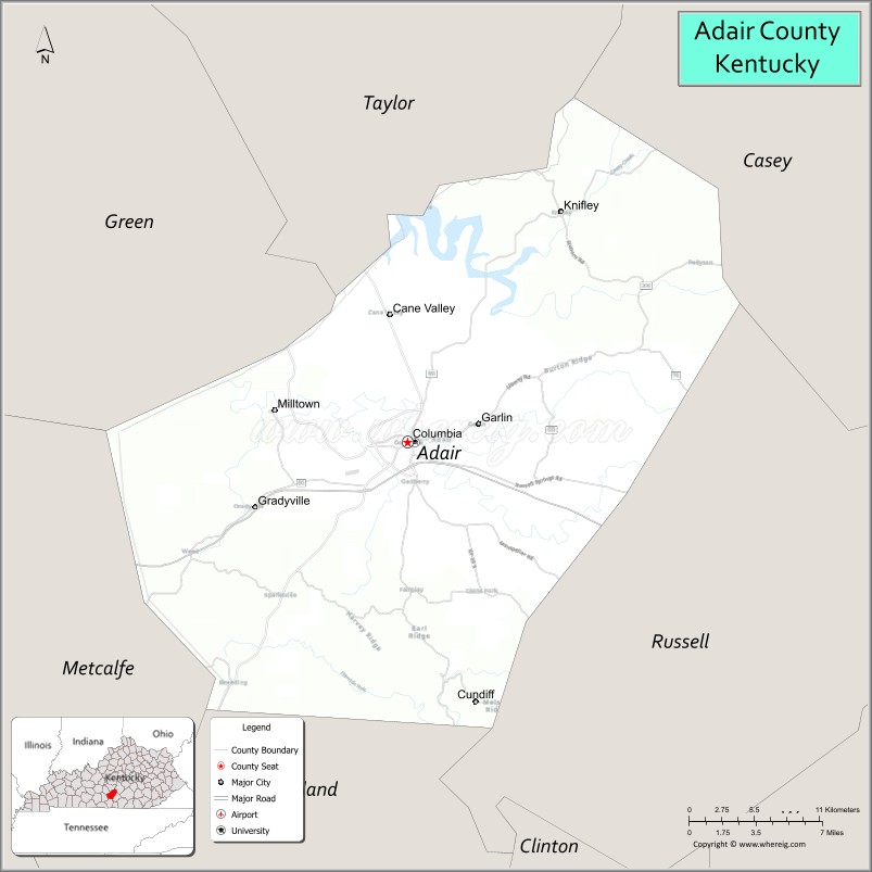
About Adair County Map, Kentucky: The map showing the county boundary, county seat, major cities, highways, water bodies and neighbouring counties.
More Kentucky Maps & Info
Map of Adair County, Kentucky
Adair County is a county located in the U.S. state of Kentucky. It's county seat is Columbia. As per 2020 census, the population of Adair County is 18932 people and population density is square miles. According to the United States Census Bureau, the county has a total area of 407 sq mi (1,054 km2). Adair County was established on 1802.
Adair County Facts
| Continent | North America |
| Country | United States |
| State | Kentucky |
| County Seat | Columbia |
| Largest City/Town | Columbia |
| Established | 1801 |
| Total Area | 412 sq mi (1,067 sq km) |
| Land Area | 405 sq mi (1,049 sq km) |
| Water Area | 7 sq mi (18 sq km) |
| Population | 18,903 (Census 2020) |
| Population Density | 46 people per sq mi |
| Time Zone | Central Time Zone (CT) |
| Major Highways | Cumberland Parkway, KY Route 55, KY Route 61, KY Route 80 |
| Major Rivers | Green River, Russell Creek |
| Neighboring Counties | Green County, Taylor County, Casey County, Russell County, Cumberland County, Metcalfe County |
| Famous For | Green River region, agriculture, Lindsey Wilson College, and historic Columbia |
| Top Attractions | Green River Lake State Park, Downtown Columbia, Holmes Bend Marina, Adair County Courthouse, Lindsey Wilson College |
| Official Website | Official Website |
About Adair County, Kentucky
Adair County is located in south-central Kentucky and was established in 1801. The county seat and largest city is Columbia. Adair County is known for its rolling farmland, Green River scenery, outdoor recreation, and strong educational presence through Lindsey Wilson College. :contentReference[oaicite:0]{index=0}
Cities and Communities in Adair County, Kentucky
| City/Town | Population | Latitude & Longitude |
|---|---|---|
| Columbia (county seat) | 4,700+ | 37.1026°N, 85.3069°W |
| Breeding | Unincorporated | 37.1567°N, 85.3569°W |
| Cane Valley | Unincorporated | 37.1483°N, 85.2419°W |
| Knifley | Unincorporated | 37.2331°N, 85.2069°W |
| Milltown | Unincorporated | 37.0618°N, 85.3922°W |
| Gradyville | Unincorporated | 37.0331°N, 85.4411°W |
| Bliss | Unincorporated | 37.2065°N, 85.3112°W |
| Montpelier | Unincorporated | 37.1264°N, 85.2453°W |
Best Golf Courses in Adair County, Kentucky
| Golf Course | Location | Latitude & Longitude |
|---|---|---|
| Lakewood Country Club | Columbia | 37.0984°N, 85.3272°W |
| The Links Resort Golf Course | Nearby Green County | 37.2506°N, 85.4985°W |
| Dale Hollow Lake Golf Course | Nearby Cumberland County | 36.7847°N, 85.3456°W |
What are Major Roads and Highways in Adair County
Several highways provide access across south-central Kentucky.
- Cumberland Parkway - major east-west route connecting Columbia with Bowling Green and Somerset
- KY Route 55 - north-south highway serving Columbia and nearby counties
- KY Route 61 - regional route connecting Columbia with Greensburg and Burkesville
- KY Route 80 - important corridor through southern Kentucky communities
Neighboring Counties of Adair County
- Green County (north)
- Taylor County (east)
- Casey County (northeast)
- Russell County (south)
- Cumberland County (southwest)
- Metcalfe County (west)
What are Top Attractions in Adair County, Kentucky
The county offers a combination of outdoor recreation, local history, and scenic countryside.
| Main Sight Name | City | Famous For |
|---|---|---|
| Green River Lake State Park | Columbia Area | Camping, boating, fishing, and hiking |
| Downtown Columbia | Columbia | Historic courthouse square and local shops |
| Lindsey Wilson College | Columbia | Private liberal arts college and athletics |
| Holmes Bend Marina | Columbia Area | Lake recreation and marina facilities |
| Adair County Courthouse | Columbia | Historic county landmark completed in the 1880s |
| Green River | Countywide | Fishing, kayaking, and scenic river views |
| Trabue-Russell House | Columbia | Historic Kentucky home and museum |
| Veterans Memorial Park | Columbia | Community recreation and memorials |
| Columbia-Adair County Welcome Center | Columbia | Tourism information and local exhibits |
| Long Hunter Scenic Area | Adair County Area | Rural Kentucky landscapes and outdoor recreation |
Distance from Adair County to Nearby Cities
The following distances are measured by road (driving).
- Columbia to Bowling Green, Kentucky - 70 mi (113 km)
- Columbia to Lexington, Kentucky - 100 mi (161 km)
- Columbia to Louisville, Kentucky - 100 mi (161 km)
- Columbia to Somerset, Kentucky - 48 mi (77 km)
- Columbia to Campbellsville, Kentucky - 24 mi (39 km)
- Columbia to Glasgow, Kentucky - 36 mi (58 km)
- Columbia to Burkesville, Kentucky - 33 mi (53 km)
- Columbia to Russell Springs, Kentucky - 20 mi (32 km)
- Columbia to Nashville, Tennessee - 130 mi (209 km)
- Columbia to Elizabethtown, Kentucky - 72 mi (116 km)
- Columbia to Danville, Kentucky - 63 mi (101 km)
- Columbia to Frankfort, Kentucky - 92 mi (148 km)
References
- U.S. Census Bureau QuickFacts
- Adair County, Kentucky - Wikipedia
- Columbia-Adair County Tourism
- Federal Reserve Economic Data - Adair County Population
- Columbia-Adair County Visitor Guide
- Adair County Map
- Allen County Map
- Anderson County Map
- Ballard County Map
- Barren County Map
- Bath County Map
- Bell County Map
- Boone County Map
- Bourbon County Map
- Boyd County Map
- Boyle County Map
- Bracken County Map
- Breathitt County Map
- Breckinridge County Map
- Bullitt County Map
- Butler County Map
- Caldwell County Map
- Calloway County Map
- Campbell County Map
- Carlisle County Map
- Carroll County Map
- Carter County Map
- Casey County Map
- Christian County Map
- Clark County Map
- Clay County Map
- Clinton County Map
- Crittenden County Map
- Cumberland County Map
- Daviess County Map
- Edmonson County Map
- Elliott County Map
- Estill County Map
- Fayette County Map
- Fleming County Map
- Floyd County Map
- Franklin County Map
- Fulton County Map
- Gallatin County Map
- Garrard County Map
- Grant County Map
- Graves County Map
- Grayson County Map
- Green County Map
- Greenup County Map
- Hancock County Map
- Hardin County Map
- Harlan County Map
- Harrison County Map
- Hart County Map
- Henderson County Map
- Henry County Map
- Hickman County Map
- Hopkins County Map
- Jackson County Map
- Jefferson County Map
- Jessamine County Map
- Johnson County Map
- Kenton County Map
- Knott County Map
- Knox County Map
- LaRue County Map
- Laurel County Map
- Lawrence County Map
- Lee County Map
- Leslie County Map
- Letcher County Map
- Lewis County Map
- Lincoln County Map
- Livingston County Map
- Logan County Map
- Lyon County Map
- McCracken County Map
- McCreary County Map
- McLean County Map
- Madison County Map
- Magoffin County Map
- Marion County Map
- Marshall County Map
- Martin County Map
- Mason County Map
- Meade County Map
- Menifee County Map
- Mercer County Map
- Metcalfe County Map
- Monroe County Map
- Montgomery County Map
- Morgan County Map
- Muhlenberg County Map
- Nelson County Map
- Nicholas County Map
- Ohio County Map
- Oldham County Map
- Owen County Map
- Owsley County Map
- Pendleton County Map
- Perry County Map
- Pike County Map
- Powell County Map
- Pulaski County Map
- Robertson County Map
- Rockcastle County Map
- Rowan County Map
- Russell County Map
- Scott County Map
- Shelby County Map
- Simpson County Map
- Spencer County Map
- Taylor County Map
- Todd County Map
- Trigg County Map
- Trimble County Map
- Union County Map
- Warren County Map
- Washington County Map
- Wayne County Map
- Webster County Map
- Whitley County Map
- Wolfe County Map
- Woodford County Map
- Alabama Counties
- Alaska boroughs
- Arizona Counties
- Arkansas Counties
- California County Map
- Colorado Counties
- Connecticut Counties
- Delaware Counties
- Florida County Map
- Georgia County Map
- Hawaii Counties
- Idaho Counties
- Illinois Counties
- Indiana Counties
- Iowa Counties
- Kansas Counties
- Kentucky Counties
- Louisiana Counties
- Maine Counties
- Maryland Counties
- Massachusetts Counties
- Michigan County Map
- Minnesota Counties
- Mississippi Counties
- Missouri Counties
- Montana Counties
- Nebraska Counties
- Nevada Counties
- New York Counties
- New Hampshire Counties
- New Jersey Counties
- New Mexico Counties
- North Carolina Counties
- North Dakota Counties
- Ohio County Map
- Oklahoma Counties
- Oregon Counties
- Pennsylvania Counties
- Rhode Island Counties
- South Carolina Counties
- South Dakota Counties
- Map of Tennessee
- Texas County Map
- Utah Counties
- Vermont Counties
- Virginia Counties
- Washington Counties
- West Virginia Counties
- Wisconsin Counties
- Wyoming Counties