Map of Breathitt County - Breathitt County is a county located in the U.S. state of Kentucky. Breathitt County Map showing cities, highways, important places and water bodies. Get Where is Breathitt County located in the map, major cities in Breathitt county, population, areas, and places of interest.
Map of Breathitt County, Kentucky
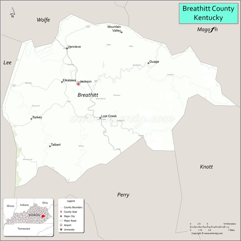
About Breathitt County Map, Kentucky: The map showing the county boundary, county seat, major cities, highways, water bodies and neighbouring counties.
More Kentucky Maps & Info
Map of Breathitt County, Kentucky
Breathitt County is a county located in the U.S. state of Kentucky. It's county seat is Jackson. As per 2020 census, the population of Breathitt County is 13553 people and population density is square miles. According to the United States Census Bureau, the county has a total area of 495 sq mi (1,282 km2). Breathitt County was established on 1839.
Breathitt County Facts
| Continent | North America |
| Country | United States |
| State | Kentucky |
| County Seat | Jackson |
| Largest City/Town | Jackson |
| Established | 1839 |
| Total Area | 495 sq mi (1,282 sq km) |
| Land Area | 492 sq mi (1,274 sq km) |
| Water Area | 2.9 sq mi (8 sq km) |
| Population | 13,718 (Census 2020) |
| Population Density | 28 people per sq mi |
| Time Zone | Eastern Time Zone (ET) |
| Major Highways | Kentucky Route 15, Kentucky Route 30, Kentucky Route 52, Kentucky Route 1098 |
| Major Rivers | North Fork Kentucky River, Troublesome Creek, Quicksand Creek |
| Neighboring Counties | Knott County, Perry County, Wolfe County, Magoffin County, Lee County, Owsley County |
| Famous For | Appalachian heritage, mountain scenery, Kentucky River valleys, and traditional mountain culture |
| Top Attractions | Panbowl Lake, Breathitt County Courthouse, Kentucky River scenic areas, Lost Creek trails, Appalachian cultural sites |
| Official Website | Official Website |
About Breathitt County, Kentucky
Breathitt County is located in the Appalachian region of eastern Kentucky and was established in 1839. The county seat and largest city is Jackson. Breathitt County is known for its mountain landscapes, Appalachian traditions, Kentucky River valleys, and rich eastern Kentucky cultural heritage. :contentReference[oaicite:0]{index=0}
Cities and Communities in Breathitt County, Kentucky
| City/Town | Population | Latitude & Longitude |
|---|---|---|
| Jackson (county seat) | 2,200+ | 37.5537°N, 83.3838°W |
| Canoe | Unincorporated | 37.5152°N, 83.3016°W |
| Quicksand | Unincorporated | 37.5230°N, 83.3558°W |
| Ned | Unincorporated | 37.4754°N, 83.2674°W |
| Lost Creek | Unincorporated | 37.4684°N, 83.4127°W |
| Talbert | Historic Community | 37.5989°N, 83.4603°W |
| Clayhole | Unincorporated | 37.5147°N, 83.2157°W |
| War Creek | Unincorporated | 37.6332°N, 83.3452°W |
Best Golf Courses in Breathitt County, Kentucky
| Golf Course | Location | Latitude & Longitude |
|---|---|---|
| Hazard Country Club | Nearby Hazard | 37.2787°N, 83.2141°W |
| Raven Rock Golf Course | Nearby Jenkins | 37.1884°N, 82.6218°W |
| Eagle Trace Golf Course | Nearby Morehead | 38.1915°N, 83.4378°W |
What are Major Roads and Highways in Breathitt County
Major highways connect Breathitt County with eastern Kentucky mountain communities and regional cities.
- Kentucky Route 15 - major north-south highway through Jackson and eastern Kentucky
- Kentucky Route 30 - regional route connecting Breathitt County with Hazard and Booneville
- Kentucky Route 52 - scenic mountain highway serving rural Appalachian communities
- Kentucky Route 1098 - local connector serving Jackson and nearby communities
Neighboring Counties of Breathitt County
- Knott County (southeast)
- Perry County (south)
- Wolfe County (northwest)
- Magoffin County (north)
- Lee County (west)
- Owsley County (southwest)
What are Top Attractions in Breathitt County, Kentucky
The county offers Appalachian mountain scenery, river valleys, and cultural heritage attractions.
| Main Sight Name | City | Famous For |
|---|---|---|
| Panbowl Lake | Jackson | Fishing, boating, and recreation |
| Breathitt County Courthouse | Jackson | Historic county landmark |
| Kentucky River Scenic Area | Countywide | Mountain river views and nature scenery |
| Lost Creek Trails | Lost Creek | Hiking and Appalachian woodland landscapes |
| Downtown Jackson | Jackson | Local shops, restaurants, and Appalachian culture |
| Appalachian Heritage Sites | Countywide | Traditional eastern Kentucky mountain culture |
| Troublesome Creek Area | Countywide | Fishing and scenic creek valleys |
| Quicksand Creek Region | Quicksand | Mountain landscapes and outdoor recreation |
| Daniel Boone National Forest Nearby Area | Regional Area | Camping, hiking, and wilderness recreation |
| Mountain Scenic Drives | Countywide | Rolling Appalachian hills and overlooks |
Distance from Breathitt County to Nearby Cities
The following distances are measured by road (driving).
- Jackson to Hazard, Kentucky - 29 mi (47 km)
- Jackson to Lexington, Kentucky - 102 mi (164 km)
- Jackson to Pikeville, Kentucky - 73 mi (117 km)
- Jackson to Morehead, Kentucky - 63 mi (101 km)
- Jackson to Richmond, Kentucky - 87 mi (140 km)
- Jackson to London, Kentucky - 78 mi (126 km)
- Jackson to Ashland, Kentucky - 92 mi (148 km)
- Jackson to Frankfort, Kentucky - 118 mi (190 km)
- Jackson to Louisville, Kentucky - 175 mi (282 km)
- Jackson to Knoxville, Tennessee - 181 mi (291 km)
- Jackson to Cincinnati, Ohio - 168 mi (270 km)
- Jackson to Charleston, West Virginia - 146 mi (235 km)
References
- Breathitt County Official Website
- Breathitt County, Kentucky - Wikipedia
- U.S. Census Bureau QuickFacts
- Kentucky Atlas and Gazetteer
- U.S. Census Bureau Profile
- Adair County Map
- Allen County Map
- Anderson County Map
- Ballard County Map
- Barren County Map
- Bath County Map
- Bell County Map
- Boone County Map
- Bourbon County Map
- Boyd County Map
- Boyle County Map
- Bracken County Map
- Breathitt County Map
- Breckinridge County Map
- Bullitt County Map
- Butler County Map
- Caldwell County Map
- Calloway County Map
- Campbell County Map
- Carlisle County Map
- Carroll County Map
- Carter County Map
- Casey County Map
- Christian County Map
- Clark County Map
- Clay County Map
- Clinton County Map
- Crittenden County Map
- Cumberland County Map
- Daviess County Map
- Edmonson County Map
- Elliott County Map
- Estill County Map
- Fayette County Map
- Fleming County Map
- Floyd County Map
- Franklin County Map
- Fulton County Map
- Gallatin County Map
- Garrard County Map
- Grant County Map
- Graves County Map
- Grayson County Map
- Green County Map
- Greenup County Map
- Hancock County Map
- Hardin County Map
- Harlan County Map
- Harrison County Map
- Hart County Map
- Henderson County Map
- Henry County Map
- Hickman County Map
- Hopkins County Map
- Jackson County Map
- Jefferson County Map
- Jessamine County Map
- Johnson County Map
- Kenton County Map
- Knott County Map
- Knox County Map
- LaRue County Map
- Laurel County Map
- Lawrence County Map
- Lee County Map
- Leslie County Map
- Letcher County Map
- Lewis County Map
- Lincoln County Map
- Livingston County Map
- Logan County Map
- Lyon County Map
- McCracken County Map
- McCreary County Map
- McLean County Map
- Madison County Map
- Magoffin County Map
- Marion County Map
- Marshall County Map
- Martin County Map
- Mason County Map
- Meade County Map
- Menifee County Map
- Mercer County Map
- Metcalfe County Map
- Monroe County Map
- Montgomery County Map
- Morgan County Map
- Muhlenberg County Map
- Nelson County Map
- Nicholas County Map
- Ohio County Map
- Oldham County Map
- Owen County Map
- Owsley County Map
- Pendleton County Map
- Perry County Map
- Pike County Map
- Powell County Map
- Pulaski County Map
- Robertson County Map
- Rockcastle County Map
- Rowan County Map
- Russell County Map
- Scott County Map
- Shelby County Map
- Simpson County Map
- Spencer County Map
- Taylor County Map
- Todd County Map
- Trigg County Map
- Trimble County Map
- Union County Map
- Warren County Map
- Washington County Map
- Wayne County Map
- Webster County Map
- Whitley County Map
- Wolfe County Map
- Woodford County Map
- Alabama Counties
- Alaska boroughs
- Arizona Counties
- Arkansas Counties
- California County Map
- Colorado Counties
- Connecticut Counties
- Delaware Counties
- Florida County Map
- Georgia County Map
- Hawaii Counties
- Idaho Counties
- Illinois Counties
- Indiana Counties
- Iowa Counties
- Kansas Counties
- Kentucky Counties
- Louisiana Counties
- Maine Counties
- Maryland Counties
- Massachusetts Counties
- Michigan County Map
- Minnesota Counties
- Mississippi Counties
- Missouri Counties
- Montana Counties
- Nebraska Counties
- Nevada Counties
- New York Counties
- New Hampshire Counties
- New Jersey Counties
- New Mexico Counties
- North Carolina Counties
- North Dakota Counties
- Ohio County Map
- Oklahoma Counties
- Oregon Counties
- Pennsylvania Counties
- Rhode Island Counties
- South Carolina Counties
- South Dakota Counties
- Map of Tennessee
- Texas County Map
- Utah Counties
- Vermont Counties
- Virginia Counties
- Washington Counties
- West Virginia Counties
- Wisconsin Counties
- Wyoming Counties