Map of Rowan County - Rowan County is a county located in the U.S. state of Kentucky. Rowan County Map showing cities, highways, important places and water bodies. Get Where is Rowan County located in the map, major cities in Rowan county, population, areas, and places of interest.
Map of Rowan County, Kentucky
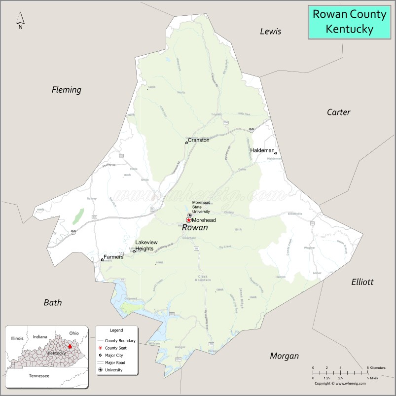
About Rowan County Map, Kentucky: The map showing the county boundary, county seat, major cities, highways, water bodies and neighbouring counties.
More Kentucky Maps & Info
Map of Rowan County, Kentucky
Rowan County is a county located in the U.S. state of Kentucky. It's county seat is Morehead. As per 2020 census, the population of Rowan County is 24861 people and population density is square miles. According to the United States Census Bureau, the county has a total area of 281 sq mi (728 km2). Rowan County was established on 1856.
Rowan County Facts
| Continent | North America |
| Country | United States |
| State | Kentucky |
| County Seat | Morehead |
| Largest City/Town | Morehead |
| Established | 1856 |
| Total Area | 280 sq mi (725 sq km) |
| Land Area | 280 sq mi (725 sq km) |
| Water Area | 0.4 sq mi (1 sq km) |
| Population | 24,662 (Census 2020) |
| Population Density | 88 people per sq mi |
| Time Zone | Eastern Time Zone (ET) |
| Major Highways | Interstate 64, U.S. Route 60, Kentucky Route 32, Kentucky Route 801 |
| Major Rivers | Licking River tributaries |
| Neighboring Counties | Lewis County, Carter County, Elliott County, Morgan County, Menifee County, Fleming County |
| Famous For | Morehead State University, Cave Run Lake nearby area, Daniel Boone National Forest, and Appalachian foothill scenery |
| Top Attractions | Morehead State University, Cave Run Lake nearby area, Daniel Boone National Forest, Kentucky Folk Art Center, Lockegee Rock |
| Official Website | Official Website |
About Rowan County, Kentucky
Rowan County is located in northeastern Kentucky within the Appalachian foothills and was established in 1856. The county seat and largest city is Morehead. Rowan County is known for Morehead State University, outdoor recreation opportunities, scenic forested hills, Cave Run Lake nearby areas, and cultural attractions tied to Appalachian heritage and eastern Kentucky tourism. ([en.wikipedia.org](https://en.wikipedia.org/wiki/Rowan_County%2C_Kentucky?utm_source=chatgpt.com))
Cities and Communities in Rowan County, Kentucky
| City/Town | Population | Latitude & Longitude |
|---|---|---|
| Morehead (county seat) | 7,000+ | 38.1839°N, 83.4327°W |
| Farmers | 300+ | 38.1498°N, 83.5413°W |
| Clearfield | Small Community | 38.1573°N, 83.4260°W |
| Haldeman | Rural Community | 38.2842°N, 83.2852°W |
| Bangor | Historic Community | 38.1226°N, 83.5008°W |
| Christy Creek | Mountain Area | 38.2331°N, 83.3724°W |
| Cranston | Unincorporated | 38.1128°N, 83.3598°W |
| Rodburn Hollow | Scenic Area | 38.2217°N, 83.4772°W |
Best Golf Courses in Rowan County, Kentucky
| Golf Course | Location | Latitude & Longitude |
|---|---|---|
| Eagle Trace Golf Course | Morehead | 38.1848°N, 83.4319°W |
| Carter Caves State Resort Golf Course | Nearby Olive Hill | 38.3721°N, 83.1238°W |
| Rolling Hills Country Club | Nearby Mount Sterling | 38.0361°N, 83.9294°W |
| Sag Hollow Golf Club | Nearby Paintsville | 37.7862°N, 82.7875°W |
What are Major Roads and Highways in Rowan County
Major highways connect Rowan County with eastern Kentucky, Lexington, and regional Appalachian tourism destinations.
- Interstate 64 - major east-west interstate through Morehead and northeastern Kentucky
- U.S. Route 60 - historic regional highway serving communities and local commerce
- Kentucky Route 32 - scenic route through Appalachian foothills and forested areas
- Kentucky Route 801 - important connector roadway serving rural communities
Neighboring Counties of Rowan County
- Lewis County (north)
- Carter County (northeast)
- Elliott County (east)
- Morgan County (south)
- Menifee County (southwest)
- Fleming County (west)
What are Top Attractions in Rowan County, Kentucky
The county offers university attractions, lakeside recreation, hiking trails, Appalachian culture, and scenic natural landmarks.
| Main Sight Name | City | Famous For |
|---|---|---|
| Morehead State University | Morehead | Higher education campus and cultural events |
| Cave Run Lake Nearby Area | Regional Area | Boating, fishing, camping, and recreation |
| Daniel Boone National Forest | Countywide | Hiking, wildlife viewing, and forest scenery |
| Kentucky Folk Art Center | Morehead | Appalachian folk art exhibits and culture |
| Lockegee Rock | Morehead Area | Scenic overlook and hiking destination |
| Historic Downtown Morehead | Morehead | Local shops, restaurants, and community events |
| Space Science Center | Morehead State University | Educational exhibits and planetarium experiences |
| Appalachian Scenic Drives | Countywide | Mountain foothill photography and countryside views |
| Outdoor Nature Trails | Countywide | Hiking and wildlife exploration |
| Community Heritage Festivals | Morehead Area | Arts, music, and local traditions |
Distance from Rowan County to Nearby Cities
The following distances are measured by road (driving).
- Morehead to Lexington, Kentucky - 64 mi (103 km)
- Morehead to Huntington, West Virginia - 82 mi (132 km)
- Morehead to Charleston, West Virginia - 122 mi (196 km)
- Morehead to Cincinnati, Ohio - 116 mi (187 km)
- Morehead to Louisville, Kentucky - 139 mi (224 km)
- Morehead to Columbus, Ohio - 177 mi (285 km)
- Morehead to Knoxville, Tennessee - 199 mi (320 km)
- Morehead to Indianapolis, Indiana - 230 mi (370 km)
- Morehead to Nashville, Tennessee - 247 mi (398 km)
- Morehead to Chicago, Illinois - 365 mi (587 km)
- Morehead to Atlanta, Georgia - 361 mi (581 km)
- Morehead to St. Louis, Missouri - 408 mi (657 km)
References
- Rowan County Official Website
- Rowan County, Kentucky - Wikipedia
- U.S. Census Bureau QuickFacts
- Morehead State University
- Daniel Boone National Forest
- Adair County Map
- Allen County Map
- Anderson County Map
- Ballard County Map
- Barren County Map
- Bath County Map
- Bell County Map
- Boone County Map
- Bourbon County Map
- Boyd County Map
- Boyle County Map
- Bracken County Map
- Breathitt County Map
- Breckinridge County Map
- Bullitt County Map
- Butler County Map
- Caldwell County Map
- Calloway County Map
- Campbell County Map
- Carlisle County Map
- Carroll County Map
- Carter County Map
- Casey County Map
- Christian County Map
- Clark County Map
- Clay County Map
- Clinton County Map
- Crittenden County Map
- Cumberland County Map
- Daviess County Map
- Edmonson County Map
- Elliott County Map
- Estill County Map
- Fayette County Map
- Fleming County Map
- Floyd County Map
- Franklin County Map
- Fulton County Map
- Gallatin County Map
- Garrard County Map
- Grant County Map
- Graves County Map
- Grayson County Map
- Green County Map
- Greenup County Map
- Hancock County Map
- Hardin County Map
- Harlan County Map
- Harrison County Map
- Hart County Map
- Henderson County Map
- Henry County Map
- Hickman County Map
- Hopkins County Map
- Jackson County Map
- Jefferson County Map
- Jessamine County Map
- Johnson County Map
- Kenton County Map
- Knott County Map
- Knox County Map
- LaRue County Map
- Laurel County Map
- Lawrence County Map
- Lee County Map
- Leslie County Map
- Letcher County Map
- Lewis County Map
- Lincoln County Map
- Livingston County Map
- Logan County Map
- Lyon County Map
- McCracken County Map
- McCreary County Map
- McLean County Map
- Madison County Map
- Magoffin County Map
- Marion County Map
- Marshall County Map
- Martin County Map
- Mason County Map
- Meade County Map
- Menifee County Map
- Mercer County Map
- Metcalfe County Map
- Monroe County Map
- Montgomery County Map
- Morgan County Map
- Muhlenberg County Map
- Nelson County Map
- Nicholas County Map
- Ohio County Map
- Oldham County Map
- Owen County Map
- Owsley County Map
- Pendleton County Map
- Perry County Map
- Pike County Map
- Powell County Map
- Pulaski County Map
- Robertson County Map
- Rockcastle County Map
- Rowan County Map
- Russell County Map
- Scott County Map
- Shelby County Map
- Simpson County Map
- Spencer County Map
- Taylor County Map
- Todd County Map
- Trigg County Map
- Trimble County Map
- Union County Map
- Warren County Map
- Washington County Map
- Wayne County Map
- Webster County Map
- Whitley County Map
- Wolfe County Map
- Woodford County Map
- Alabama Counties
- Alaska boroughs
- Arizona Counties
- Arkansas Counties
- California County Map
- Colorado Counties
- Connecticut Counties
- Delaware Counties
- Florida County Map
- Georgia County Map
- Hawaii Counties
- Idaho Counties
- Illinois Counties
- Indiana Counties
- Iowa Counties
- Kansas Counties
- Kentucky Counties
- Louisiana Counties
- Maine Counties
- Maryland Counties
- Massachusetts Counties
- Michigan County Map
- Minnesota Counties
- Mississippi Counties
- Missouri Counties
- Montana Counties
- Nebraska Counties
- Nevada Counties
- New York Counties
- New Hampshire Counties
- New Jersey Counties
- New Mexico Counties
- North Carolina Counties
- North Dakota Counties
- Ohio County Map
- Oklahoma Counties
- Oregon Counties
- Pennsylvania Counties
- Rhode Island Counties
- South Carolina Counties
- South Dakota Counties
- Map of Tennessee
- Texas County Map
- Utah Counties
- Vermont Counties
- Virginia Counties
- Washington Counties
- West Virginia Counties
- Wisconsin Counties
- Wyoming Counties