Map of Warren County - Warren County is a county located in the U.S. state of Kentucky. Warren County Map showing cities, highways, important places and water bodies. Get Where is Warren County located in the map, major cities in Warren county, population, areas, and places of interest.
Map of Warren County, Kentucky
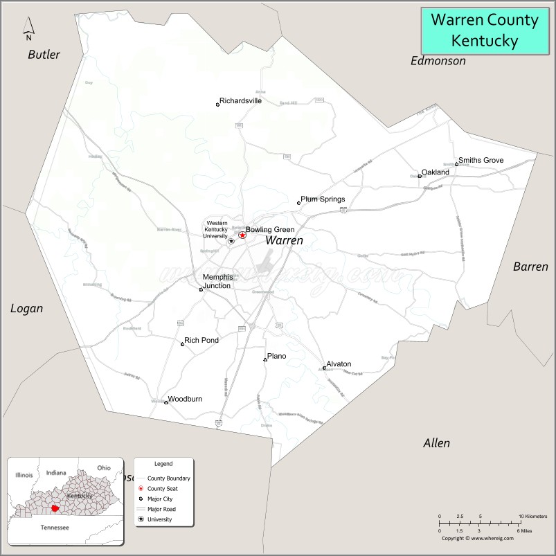
About Warren County Map, Kentucky: The map showing the county boundary, county seat, major cities, highways, water bodies and neighbouring counties.
More Kentucky Maps & Info
Map of Warren County, Kentucky
Warren County is a county located in the U.S. state of Kentucky. It's county seat is Bowling Green. As per 2020 census, the population of Warren County is 137212 people and population density is square miles. According to the United States Census Bureau, the county has a total area of 545 sq mi (1,412 km2). Warren County was established on 1796.
Warren County Facts
| Continent | North America |
| Country | United States |
| State | Kentucky |
| County Seat | Bowling Green |
| Largest City/Town | Bowling Green |
| Established | 1796 |
| Total Area | 548 sq mi (1,419 sq km) |
| Land Area | 542 sq mi (1,404 sq km) |
| Water Area | 6 sq mi (16 sq km) |
| Population | 134,554 (Census 2020) |
| Population Density | 248 people per sq mi |
| Time Zone | Central Time Zone (CT) |
| Major Highways | Interstate 65, U.S. Route 31W, U.S. Route 68, U.S. Route 231 |
| Major Rivers | Barren River, Green River |
| Neighboring Counties | Butler County, Edmonson County, Allen County, Simpson County, Logan County, Barren County |
| Famous For | Western Kentucky University, National Corvette Museum, Corvette Assembly Plant, and Bowling Green attractions |
| Top Attractions | National Corvette Museum, Lost River Cave, Beech Bend Park, Historic RailPark, Western Kentucky University |
| Official Website | Official Website |
About Warren County, Kentucky
Warren County is located in south-central Kentucky and was established in 1796. The county seat and largest city is Bowling Green. Warren County is one of Kentucky’s fastest-growing regions and is widely known for Western Kentucky University, the National Corvette Museum, the General Motors Corvette Assembly Plant, historic attractions, and major tourism and manufacturing industries. :contentReference[oaicite:0]{index=0}
Cities and Communities in Warren County, Kentucky
| City/Town | Population | Latitude & Longitude |
|---|---|---|
| Bowling Green (county seat) | 72,000+ | 36.9685°N, 86.4808°W |
| Smiths Grove | 800+ | 37.0520°N, 86.2055°W |
| Oakland | 300+ | 37.0428°N, 86.2503°W |
| Woodburn | 400+ | 36.8428°N, 86.5317°W |
| Plum Springs | 500+ | 37.0306°N, 86.3739°W |
| Plano | Community | 36.8809°N, 86.4214°W |
| Alvaton | Rural Community | 36.8637°N, 86.3561°W |
| Rockfield | Unincorporated | 36.8823°N, 86.5658°W |
Best Golf Courses in Warren County, Kentucky
| Golf Course | Location | Latitude & Longitude |
|---|---|---|
| CrossWinds Golf Course | Bowling Green | 36.9348°N, 86.4287°W |
| The Club at Olde Stone | Bowling Green | 36.9505°N, 86.3812°W |
| Indian Hills Country Club | Bowling Green | 36.9737°N, 86.4365°W |
| Paul Walker Golf Course | Bowling Green | 36.9877°N, 86.4412°W |
What are Major Roads and Highways in Warren County
Major highways connect Warren County with Louisville, Nashville, and important south-central Kentucky economic corridors. :contentReference[oaicite:1]{index=1}
- Interstate 65 - major north-south interstate linking Louisville and Nashville
- U.S. Route 31W - historic regional highway through Bowling Green
- U.S. Route 68 - important east-west transportation corridor
- U.S. Route 231 - major connector route serving commercial and residential areas
Neighboring Counties of Warren County
- Butler County (northwest)
- Edmonson County (north)
- Allen County (east)
- Simpson County (south)
- Logan County (southwest)
- Barren County (east)
What are Top Attractions in Warren County, Kentucky
The county offers museums, caves, amusement parks, motorsports attractions, university events, and family-friendly tourism destinations. :contentReference[oaicite:2]{index=2}
| Main Sight Name | City | Famous For |
|---|---|---|
| National Corvette Museum | Bowling Green | Corvette history, exhibits, and sports car collections |
| Lost River Cave | Bowling Green | Underground boat tours and cave exploration |
| Beech Bend Park | Bowling Green | Amusement rides, water park, and drag racing |
| Historic RailPark and Train Museum | Bowling Green | Historic railcars and railroad heritage |
| Western Kentucky University | Bowling Green | University campus and cultural events |
| Corvette Assembly Plant | Bowling Green | Manufacturing facility producing Chevrolet Corvettes |
| Barren River Recreation Areas | Countywide | Fishing, boating, and outdoor recreation |
| Historic Downtown Bowling Green | Bowling Green | Restaurants, shops, and historic architecture |
| Aviation Heritage Park | Bowling Green | Historic aircraft displays and aviation exhibits |
| Kentucky Museum | Bowling Green | Regional history and cultural collections |
Distance from Warren County to Nearby Cities
The following distances are measured by road (driving).
- Bowling Green to Nashville, Tennessee - 67 mi (108 km)
- Bowling Green to Louisville, Kentucky - 114 mi (183 km)
- Bowling Green to Clarksville, Tennessee - 71 mi (114 km)
- Bowling Green to Lexington, Kentucky - 113 mi (182 km)
- Bowling Green to Evansville, Indiana - 116 mi (187 km)
- Bowling Green to Knoxville, Tennessee - 214 mi (344 km)
- Bowling Green to Cincinnati, Ohio - 212 mi (341 km)
- Bowling Green to Indianapolis, Indiana - 230 mi (370 km)
- Bowling Green to Memphis, Tennessee - 236 mi (380 km)
- Bowling Green to Atlanta, Georgia - 288 mi (463 km)
- Bowling Green to Chicago, Illinois - 381 mi (613 km)
- Bowling Green to St. Louis, Missouri - 287 mi (462 km)
References
- Warren County Government
- Warren County, Kentucky - Wikipedia
- U.S. Census Bureau QuickFacts
- City of Bowling Green
- Visit Bowling Green Kentucky
- Adair County Map
- Allen County Map
- Anderson County Map
- Ballard County Map
- Barren County Map
- Bath County Map
- Bell County Map
- Boone County Map
- Bourbon County Map
- Boyd County Map
- Boyle County Map
- Bracken County Map
- Breathitt County Map
- Breckinridge County Map
- Bullitt County Map
- Butler County Map
- Caldwell County Map
- Calloway County Map
- Campbell County Map
- Carlisle County Map
- Carroll County Map
- Carter County Map
- Casey County Map
- Christian County Map
- Clark County Map
- Clay County Map
- Clinton County Map
- Crittenden County Map
- Cumberland County Map
- Daviess County Map
- Edmonson County Map
- Elliott County Map
- Estill County Map
- Fayette County Map
- Fleming County Map
- Floyd County Map
- Franklin County Map
- Fulton County Map
- Gallatin County Map
- Garrard County Map
- Grant County Map
- Graves County Map
- Grayson County Map
- Green County Map
- Greenup County Map
- Hancock County Map
- Hardin County Map
- Harlan County Map
- Harrison County Map
- Hart County Map
- Henderson County Map
- Henry County Map
- Hickman County Map
- Hopkins County Map
- Jackson County Map
- Jefferson County Map
- Jessamine County Map
- Johnson County Map
- Kenton County Map
- Knott County Map
- Knox County Map
- LaRue County Map
- Laurel County Map
- Lawrence County Map
- Lee County Map
- Leslie County Map
- Letcher County Map
- Lewis County Map
- Lincoln County Map
- Livingston County Map
- Logan County Map
- Lyon County Map
- McCracken County Map
- McCreary County Map
- McLean County Map
- Madison County Map
- Magoffin County Map
- Marion County Map
- Marshall County Map
- Martin County Map
- Mason County Map
- Meade County Map
- Menifee County Map
- Mercer County Map
- Metcalfe County Map
- Monroe County Map
- Montgomery County Map
- Morgan County Map
- Muhlenberg County Map
- Nelson County Map
- Nicholas County Map
- Ohio County Map
- Oldham County Map
- Owen County Map
- Owsley County Map
- Pendleton County Map
- Perry County Map
- Pike County Map
- Powell County Map
- Pulaski County Map
- Robertson County Map
- Rockcastle County Map
- Rowan County Map
- Russell County Map
- Scott County Map
- Shelby County Map
- Simpson County Map
- Spencer County Map
- Taylor County Map
- Todd County Map
- Trigg County Map
- Trimble County Map
- Union County Map
- Warren County Map
- Washington County Map
- Wayne County Map
- Webster County Map
- Whitley County Map
- Wolfe County Map
- Woodford County Map
- Alabama Counties
- Alaska boroughs
- Arizona Counties
- Arkansas Counties
- California County Map
- Colorado Counties
- Connecticut Counties
- Delaware Counties
- Florida County Map
- Georgia County Map
- Hawaii Counties
- Idaho Counties
- Illinois Counties
- Indiana Counties
- Iowa Counties
- Kansas Counties
- Kentucky Counties
- Louisiana Counties
- Maine Counties
- Maryland Counties
- Massachusetts Counties
- Michigan County Map
- Minnesota Counties
- Mississippi Counties
- Missouri Counties
- Montana Counties
- Nebraska Counties
- Nevada Counties
- New York Counties
- New Hampshire Counties
- New Jersey Counties
- New Mexico Counties
- North Carolina Counties
- North Dakota Counties
- Ohio County Map
- Oklahoma Counties
- Oregon Counties
- Pennsylvania Counties
- Rhode Island Counties
- South Carolina Counties
- South Dakota Counties
- Map of Tennessee
- Texas County Map
- Utah Counties
- Vermont Counties
- Virginia Counties
- Washington Counties
- West Virginia Counties
- Wisconsin Counties
- Wyoming Counties