Map of Lyon County - Lyon County is a county located in the U.S. state of Kentucky. Lyon County Map showing cities, highways, important places and water bodies. Get Where is Lyon County located in the map, major cities in Lyon county, population, areas, and places of interest.
Map of Lyon County, Kentucky
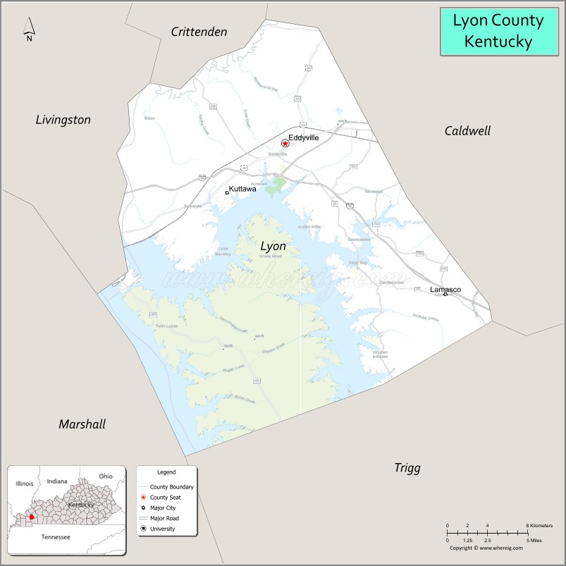
About Lyon County Map, Kentucky: The map showing the county boundary, county seat, major cities, highways, water bodies and neighbouring counties.
More Kentucky Maps & Info
Map of Lyon County, Kentucky
Lyon County is a county located in the U.S. state of Kentucky. It's county seat is Eddyville. As per 2020 census, the population of Lyon County is 8803 people and population density is square miles. According to the United States Census Bureau, the county has a total area of 216 sq mi (559 km2). Lyon County was established on 1854.
Lyon County Facts
| Continent | North America |
| Country | United States |
| State | Kentucky |
| County Seat | Eddyville |
| Largest City/Town | Eddyville |
| Established | 1854 |
| Total Area | 257 sq mi (666 sq km) |
| Land Area | 214 sq mi (554 sq km) |
| Water Area | 43 sq mi (111 sq km) |
| Population | 8,680 (Census 2020) |
| Population Density | 41 people per sq mi |
| Time Zone | Central Time Zone (CT) |
| Major Highways | Interstate 24, Interstate 69, U.S. Route 62, Kentucky Route 93, Kentucky Route 295 |
| Major Rivers | Cumberland River, Tennessee River |
| Neighboring Counties | Crittenden County, Caldwell County, Trigg County, Marshall County, Livingston County |
| Famous For | Land Between the Lakes, Kentucky Lake recreation, Lake Barkley, and outdoor tourism |
| Top Attractions | Land Between the Lakes National Recreation Area, Venture River Water Park, Lake Barkley, Kuttawa Harbor Marina, Eddyville Historic Area |
| Official Website | Official Website |
About Lyon County, Kentucky
Lyon County is located in western Kentucky and was established in 1854 from Caldwell County. The county seat and largest city is Eddyville. Lyon County is widely known for its scenic lake landscapes, boating recreation, Land Between the Lakes National Recreation Area, and tourism centered around Kentucky Lake and Lake Barkley. :contentReference[oaicite:0]{index=0}
Cities and Communities in Lyon County, Kentucky
| City/Town | Population | Latitude & Longitude |
|---|---|---|
| Eddyville (county seat) | 2,300+ | 37.0948°N, 88.0792°W |
| Kuttawa | 600+ | 37.0589°N, 88.1328°W |
| Eddy Bay | Lake Community | 37.0668°N, 88.0714°W |
| Lamasco | Historic Community | 37.1847°N, 88.0361°W |
| Suwanee | Rural Community | 37.0345°N, 88.0437°W |
| Commerce Landing | River Community | 37.1130°N, 88.1215°W |
| Palisades | Residential Community | 37.0802°N, 88.1448°W |
| Twin Lakes | Lake Area Community | 37.0495°N, 88.1109°W |
Best Golf Courses in Lyon County, Kentucky
| Golf Course | Location | Latitude & Longitude |
|---|---|---|
| Kentucky Dam Village Golf Course | Nearby Gilbertsville | 37.0147°N, 88.2708°W |
| Calvert City Golf & Country Club | Nearby Calvert City | 37.0228°N, 88.3382°W |
| Drake Creek Golf Club | Nearby Ledbetter | 37.0415°N, 88.4917°W |
| Benton Golf & Country Club | Nearby Benton | 36.8870°N, 88.3544°W |
What are Major Roads and Highways in Lyon County
Major highways connect Lyon County with western Kentucky lake communities, Tennessee, Illinois, and regional recreation destinations.
- Interstate 24 - major east-west interstate through western Kentucky
- Interstate 69 - important north-south transportation corridor
- U.S. Route 62 - regional highway connecting Eddyville, Kuttawa, and surrounding communities
- Kentucky Route 93 - scenic roadway through lake and forest areas
- Kentucky Route 295 - connector route into Land Between the Lakes
Neighboring Counties of Lyon County
- Crittenden County (north)
- Caldwell County (east)
- Trigg County (south)
- Marshall County (southwest)
- Livingston County (northwest)
What are Top Attractions in Lyon County, Kentucky
The county offers lake recreation, marinas, forest scenery, boating destinations, and family tourism attractions.
| Main Sight Name | City | Famous For |
|---|---|---|
| Land Between the Lakes National Recreation Area | Kuttawa Area | Camping, hiking, wildlife viewing, and outdoor recreation |
| Venture River Water Park | Eddyville | Family water attractions and summer recreation |
| Lake Barkley | Countywide | Boating, fishing, and scenic waterfront views |
| Kuttawa Harbor Marina | Kuttawa | Lake access and marina recreation |
| Eddyville Historic Area | Eddyville | Historic downtown and local heritage |
| Kentucky Lake Scenic Areas | Countywide | Water recreation and photography |
| The Homeplace 1850s Farm Nearby Area | LBL Region | Living history farm and pioneer demonstrations |
| Prizer Point Marina Nearby Area | Lake Barkley Area | Resort activities and boating |
| Fishing and Camping Areas | Countywide | Outdoor recreation and lakeside camping |
| Scenic Lake Drives | Countywide | Forest landscapes and waterfront scenery |
Distance from Lyon County to Nearby Cities
The following distances are measured by road (driving).
- Eddyville to Paducah, Kentucky - 38 mi (61 km)
- Eddyville to Murray, Kentucky - 46 mi (74 km)
- Eddyville to Nashville, Tennessee - 110 mi (177 km)
- Eddyville to Evansville, Indiana - 112 mi (180 km)
- Eddyville to Clarksville, Tennessee - 83 mi (134 km)
- Eddyville to Louisville, Kentucky - 216 mi (348 km)
- Eddyville to Memphis, Tennessee - 193 mi (311 km)
- Eddyville to St. Louis, Missouri - 183 mi (295 km)
- Eddyville to Lexington, Kentucky - 250 mi (402 km)
- Eddyville to Indianapolis, Indiana - 248 mi (399 km)
- Eddyville to Cincinnati, Ohio - 303 mi (488 km)
- Eddyville to Chicago, Illinois - 352 mi (566 km)
References
- Lyon County Official Website
- Lyon County, Kentucky - Wikipedia
- U.S. Census Bureau QuickFacts
- Land Between the Lakes National Recreation Area
- Kentucky Lake Tourism Guide
- Adair County Map
- Allen County Map
- Anderson County Map
- Ballard County Map
- Barren County Map
- Bath County Map
- Bell County Map
- Boone County Map
- Bourbon County Map
- Boyd County Map
- Boyle County Map
- Bracken County Map
- Breathitt County Map
- Breckinridge County Map
- Bullitt County Map
- Butler County Map
- Caldwell County Map
- Calloway County Map
- Campbell County Map
- Carlisle County Map
- Carroll County Map
- Carter County Map
- Casey County Map
- Christian County Map
- Clark County Map
- Clay County Map
- Clinton County Map
- Crittenden County Map
- Cumberland County Map
- Daviess County Map
- Edmonson County Map
- Elliott County Map
- Estill County Map
- Fayette County Map
- Fleming County Map
- Floyd County Map
- Franklin County Map
- Fulton County Map
- Gallatin County Map
- Garrard County Map
- Grant County Map
- Graves County Map
- Grayson County Map
- Green County Map
- Greenup County Map
- Hancock County Map
- Hardin County Map
- Harlan County Map
- Harrison County Map
- Hart County Map
- Henderson County Map
- Henry County Map
- Hickman County Map
- Hopkins County Map
- Jackson County Map
- Jefferson County Map
- Jessamine County Map
- Johnson County Map
- Kenton County Map
- Knott County Map
- Knox County Map
- LaRue County Map
- Laurel County Map
- Lawrence County Map
- Lee County Map
- Leslie County Map
- Letcher County Map
- Lewis County Map
- Lincoln County Map
- Livingston County Map
- Logan County Map
- Lyon County Map
- McCracken County Map
- McCreary County Map
- McLean County Map
- Madison County Map
- Magoffin County Map
- Marion County Map
- Marshall County Map
- Martin County Map
- Mason County Map
- Meade County Map
- Menifee County Map
- Mercer County Map
- Metcalfe County Map
- Monroe County Map
- Montgomery County Map
- Morgan County Map
- Muhlenberg County Map
- Nelson County Map
- Nicholas County Map
- Ohio County Map
- Oldham County Map
- Owen County Map
- Owsley County Map
- Pendleton County Map
- Perry County Map
- Pike County Map
- Powell County Map
- Pulaski County Map
- Robertson County Map
- Rockcastle County Map
- Rowan County Map
- Russell County Map
- Scott County Map
- Shelby County Map
- Simpson County Map
- Spencer County Map
- Taylor County Map
- Todd County Map
- Trigg County Map
- Trimble County Map
- Union County Map
- Warren County Map
- Washington County Map
- Wayne County Map
- Webster County Map
- Whitley County Map
- Wolfe County Map
- Woodford County Map
- Alabama Counties
- Alaska boroughs
- Arizona Counties
- Arkansas Counties
- California County Map
- Colorado Counties
- Connecticut Counties
- Delaware Counties
- Florida County Map
- Georgia County Map
- Hawaii Counties
- Idaho Counties
- Illinois Counties
- Indiana Counties
- Iowa Counties
- Kansas Counties
- Kentucky Counties
- Louisiana Counties
- Maine Counties
- Maryland Counties
- Massachusetts Counties
- Michigan County Map
- Minnesota Counties
- Mississippi Counties
- Missouri Counties
- Montana Counties
- Nebraska Counties
- Nevada Counties
- New York Counties
- New Hampshire Counties
- New Jersey Counties
- New Mexico Counties
- North Carolina Counties
- North Dakota Counties
- Ohio County Map
- Oklahoma Counties
- Oregon Counties
- Pennsylvania Counties
- Rhode Island Counties
- South Carolina Counties
- South Dakota Counties
- Map of Tennessee
- Texas County Map
- Utah Counties
- Vermont Counties
- Virginia Counties
- Washington Counties
- West Virginia Counties
- Wisconsin Counties
- Wyoming Counties