Map of Barren County - Barren County is a county located in the U.S. state of Kentucky. Barren County Map showing cities, highways, important places and water bodies. Get Where is Barren County located in the map, major cities in Barren county, population, areas, and places of interest.
Map of Barren County, Kentucky
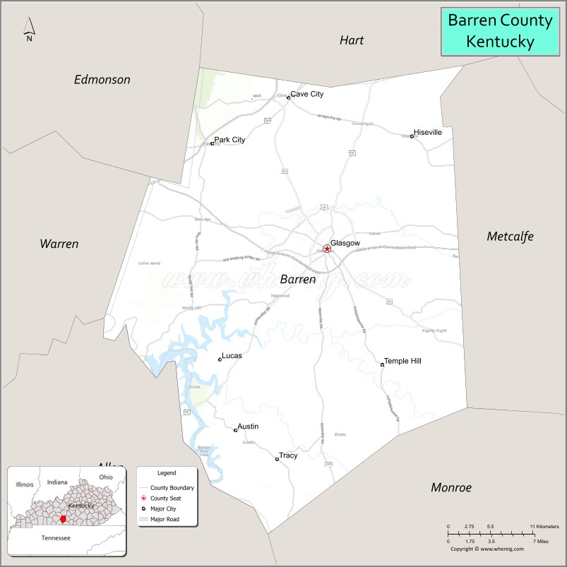
About Barren County Map, Kentucky: The map showing the county boundary, county seat, major cities, highways, water bodies and neighbouring counties.
More Kentucky Maps & Info
Map of Barren County, Kentucky
Barren County is a county located in the U.S. state of Kentucky. It's county seat is Glasgow. As per 2020 census, the population of Barren County is 44544 people and population density is square miles. According to the United States Census Bureau, the county has a total area of 491 sq mi (1,272 km2). Barren County was established on 1798.
Barren County Facts
| Continent | North America |
| Country | United States |
| State | Kentucky |
| County Seat | Glasgow |
| Largest City/Town | Glasgow |
| Established | 1798 |
| Total Area | 500 sq mi (1,295 sq km) |
| Land Area | 488 sq mi (1,264 sq km) |
| Water Area | 12 sq mi (31 sq km) |
| Population | 44,485 (Census 2020) |
| Population Density | 91.2 people per sq mi |
| Time Zone | Central Time Zone (CT) |
| Major Highways | Interstate 65, U.S. Route 31E, KY Route 90, Cumberland Parkway |
| Major Rivers | Barren River, Little Barren River |
| Neighboring Counties | Hart County, Metcalfe County, Monroe County, Allen County, Warren County, Edmonson County |
| Famous For | Mammoth Cave region, Glasgow Highland Games, agriculture, and rural Kentucky heritage |
| Top Attractions | Mammoth Cave nearby area, Downtown Glasgow, Barren River Lake, Highland Games, Yancey's Gastropub district |
| Official Website | Official Website |
About Barren County, Kentucky
Barren County is located in south-central Kentucky and was established in 1798 from portions of Warren and Green counties. The county seat and largest city is Glasgow, which was named after Glasgow, Scotland. Barren County is known for its fertile farmland, Scottish heritage celebrations, cave country tourism, and scenic Barren River landscapes. :contentReference[oaicite:0]{index=0}
Cities and Communities in Barren County, Kentucky
| City/Town | Population | Latitude & Longitude |
|---|---|---|
| Glasgow (county seat) | 15,014+ | 37.0003°N, 85.9200°W |
| Cave City | 2,240+ | 37.1367°N, 85.9564°W |
| Park City | 725+ | 37.0934°N, 86.0519°W |
| Hiseville | 250+ | 37.1028°N, 85.8177°W |
| Eighty Eight | Unincorporated | 36.8926°N, 85.8369°W |
| Temple Hill | Unincorporated | 36.9314°N, 85.7277°W |
| Austin | Unincorporated | 36.9920°N, 85.8969°W |
| Red Cross | Unincorporated | 37.1578°N, 85.7458°W |
Best Golf Courses in Barren County, Kentucky
| Golf Course | Location | Latitude & Longitude |
|---|---|---|
| Fox Hollow Golf Club | Glasgow | 37.0198°N, 85.9022°W |
| Willow Oaks Golf Club | Glasgow | 36.9908°N, 85.9412°W |
| Cave Valley Golf Club | Cave City | 37.1319°N, 85.9490°W |
| Barren River Lake State Resort Park Golf Course | Nearby Lucas | 36.9158°N, 86.0346°W |
What are Major Roads and Highways in Barren County
Major highways provide access across south-central Kentucky and nearby cave country attractions.
- Interstate 65 - major north-south interstate connecting Cave City with Louisville and Nashville
- U.S. Route 31E - regional route linking Glasgow with Elizabethtown and Bowling Green
- KY Route 90 - east-west highway connecting Glasgow with Lake Cumberland and western Kentucky
- Cumberland Parkway - major parkway serving Glasgow and surrounding counties
Neighboring Counties of Barren County
- Hart County (north)
- Metcalfe County (east)
- Monroe County (south)
- Allen County (southwest)
- Warren County (west)
- Edmonson County (northwest)
What are Top Attractions in Barren County, Kentucky
The county features cave country tourism, Scottish heritage, and outdoor recreation.
| Main Sight Name | City | Famous For |
|---|---|---|
| Mammoth Cave Nearby Area | Cave City | World-famous cave system and national park access |
| Downtown Glasgow | Glasgow | Historic buildings, local shops, and restaurants |
| Glasgow Highland Games | Glasgow | Annual Scottish cultural festival and athletics |
| Barren River Lake | Barren County Area | Boating, fishing, and camping recreation |
| South Central Kentucky Cultural Center | Glasgow | Regional history and cultural exhibits |
| Plaza Theatre | Glasgow | Historic performing arts venue |
| Dinosaur World Kentucky | Cave City | Family attraction with life-sized dinosaur displays |
| Yancey's Gastropub District | Glasgow | Dining and local entertainment area |
| Barren County Courthouse | Glasgow | Historic county landmark and civic center |
| Hidden River Cave Nearby Area | Horse Cave Area | Cave tours and underground river experiences |
Distance from Barren County to Nearby Cities
The following distances are measured by road (driving).
- Glasgow to Bowling Green, Kentucky - 38 mi (61 km)
- Glasgow to Louisville, Kentucky - 111 mi (179 km)
- Glasgow to Lexington, Kentucky - 129 mi (208 km)
- Glasgow to Nashville, Tennessee - 92 mi (148 km)
- Glasgow to Elizabethtown, Kentucky - 68 mi (109 km)
- Glasgow to Columbia, Kentucky - 36 mi (58 km)
- Glasgow to Somerset, Kentucky - 68 mi (109 km)
- Glasgow to Cave City, Kentucky - 11 mi (18 km)
- Glasgow to Franklin, Kentucky - 42 mi (68 km)
- Glasgow to Paducah, Kentucky - 171 mi (275 km)
- Glasgow to Owensboro, Kentucky - 105 mi (169 km)
- Glasgow to Cookeville, Tennessee - 84 mi (135 km)
References
- Barren County Official Website
- Barren County, Kentucky - Wikipedia
- U.S. Census Bureau QuickFacts
- Kentucky Historical Society
- City of Glasgow Official Website
- Adair County Map
- Allen County Map
- Anderson County Map
- Ballard County Map
- Barren County Map
- Bath County Map
- Bell County Map
- Boone County Map
- Bourbon County Map
- Boyd County Map
- Boyle County Map
- Bracken County Map
- Breathitt County Map
- Breckinridge County Map
- Bullitt County Map
- Butler County Map
- Caldwell County Map
- Calloway County Map
- Campbell County Map
- Carlisle County Map
- Carroll County Map
- Carter County Map
- Casey County Map
- Christian County Map
- Clark County Map
- Clay County Map
- Clinton County Map
- Crittenden County Map
- Cumberland County Map
- Daviess County Map
- Edmonson County Map
- Elliott County Map
- Estill County Map
- Fayette County Map
- Fleming County Map
- Floyd County Map
- Franklin County Map
- Fulton County Map
- Gallatin County Map
- Garrard County Map
- Grant County Map
- Graves County Map
- Grayson County Map
- Green County Map
- Greenup County Map
- Hancock County Map
- Hardin County Map
- Harlan County Map
- Harrison County Map
- Hart County Map
- Henderson County Map
- Henry County Map
- Hickman County Map
- Hopkins County Map
- Jackson County Map
- Jefferson County Map
- Jessamine County Map
- Johnson County Map
- Kenton County Map
- Knott County Map
- Knox County Map
- LaRue County Map
- Laurel County Map
- Lawrence County Map
- Lee County Map
- Leslie County Map
- Letcher County Map
- Lewis County Map
- Lincoln County Map
- Livingston County Map
- Logan County Map
- Lyon County Map
- McCracken County Map
- McCreary County Map
- McLean County Map
- Madison County Map
- Magoffin County Map
- Marion County Map
- Marshall County Map
- Martin County Map
- Mason County Map
- Meade County Map
- Menifee County Map
- Mercer County Map
- Metcalfe County Map
- Monroe County Map
- Montgomery County Map
- Morgan County Map
- Muhlenberg County Map
- Nelson County Map
- Nicholas County Map
- Ohio County Map
- Oldham County Map
- Owen County Map
- Owsley County Map
- Pendleton County Map
- Perry County Map
- Pike County Map
- Powell County Map
- Pulaski County Map
- Robertson County Map
- Rockcastle County Map
- Rowan County Map
- Russell County Map
- Scott County Map
- Shelby County Map
- Simpson County Map
- Spencer County Map
- Taylor County Map
- Todd County Map
- Trigg County Map
- Trimble County Map
- Union County Map
- Warren County Map
- Washington County Map
- Wayne County Map
- Webster County Map
- Whitley County Map
- Wolfe County Map
- Woodford County Map
- Alabama Counties
- Alaska boroughs
- Arizona Counties
- Arkansas Counties
- California County Map
- Colorado Counties
- Connecticut Counties
- Delaware Counties
- Florida County Map
- Georgia County Map
- Hawaii Counties
- Idaho Counties
- Illinois Counties
- Indiana Counties
- Iowa Counties
- Kansas Counties
- Kentucky Counties
- Louisiana Counties
- Maine Counties
- Maryland Counties
- Massachusetts Counties
- Michigan County Map
- Minnesota Counties
- Mississippi Counties
- Missouri Counties
- Montana Counties
- Nebraska Counties
- Nevada Counties
- New York Counties
- New Hampshire Counties
- New Jersey Counties
- New Mexico Counties
- North Carolina Counties
- North Dakota Counties
- Ohio County Map
- Oklahoma Counties
- Oregon Counties
- Pennsylvania Counties
- Rhode Island Counties
- South Carolina Counties
- South Dakota Counties
- Map of Tennessee
- Texas County Map
- Utah Counties
- Vermont Counties
- Virginia Counties
- Washington Counties
- West Virginia Counties
- Wisconsin Counties
- Wyoming Counties