Map of Montgomery County - Montgomery County is a county located in the U.S. state of Kentucky. Montgomery County Map showing cities, highways, important places and water bodies. Get Where is Montgomery County located in the map, major cities in Montgomery county, population, areas, and places of interest.
Map of Montgomery County, Kentucky
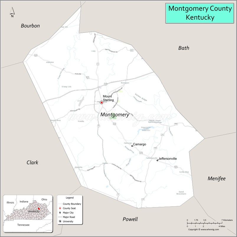
About Montgomery County Map, Kentucky: The map showing the county boundary, county seat, major cities, highways, water bodies and neighbouring counties.
More Kentucky Maps & Info
Map of Montgomery County, Kentucky
Montgomery County is a county located in the U.S. state of Kentucky. It's county seat is Mount Sterling. As per 2020 census, the population of Montgomery County is 28219 people and population density is square miles. According to the United States Census Bureau, the county has a total area of 199 sq mi (515 km2). Montgomery County was established on 1796.
Montgomery County Facts
| Continent | North America |
| Country | United States |
| State | Kentucky |
| County Seat | Mount Sterling |
| Largest City/Town | Mount Sterling |
| Established | 1796 |
| Total Area | 200 sq mi (518 sq km) |
| Land Area | 197 sq mi (510 sq km) |
| Water Area | 2.7 sq mi (7 sq km) |
| Population | 28,114 (Census 2020) |
| Population Density | 143 people per sq mi |
| Time Zone | Eastern Time Zone (ET) |
| Major Highways | Interstate 64, U.S. Route 60, U.S. Route 460, Kentucky Route 11 |
| Major Rivers | Licking River, Slate Creek |
| Neighboring Counties | Bath County, Menifee County, Powell County, Clark County, Bourbon County |
| Famous For | Mount Sterling Court Days Festival, Bluegrass horse farms, historic downtown, and eastern Kentucky gateway |
| Top Attractions | Court Days Festival, Downtown Mount Sterling Historic District, Easy Walker Park, Ruth Hunt Candy Company, Samuel Wilson House |
| Official Website | Official Website |
About Montgomery County, Kentucky
Montgomery County is located in east-central Kentucky within the Bluegrass region and was established in 1796. The county seat and largest city is Mount Sterling. Montgomery County is known for its historic downtown district, annual Court Days Festival, horse farms, rolling countryside, and strong ties to Kentucky Bluegrass culture and commerce. ([en.wikipedia.org](https://en.wikipedia.org/wiki/Montgomery_County%2C_Kentucky?utm_source=chatgpt.com))
Cities and Communities in Montgomery County, Kentucky
| City/Town | Population | Latitude & Longitude |
|---|---|---|
| Mount Sterling (county seat) | 7,500+ | 38.0565°N, 83.9430°W |
| Jeffersonville | 1,600+ | 38.1606°N, 83.8116°W |
| Camargo | 800+ | 37.9990°N, 83.8902°W |
| Levee | Rural Community | 38.1164°N, 84.0205°W |
| Means Nearby Area | Regional Community | 38.0698°N, 83.7351°W |
| Prewitt | Historic Community | 38.0452°N, 83.8295°W |
| Sideview | Residential Community | 38.0324°N, 83.9787°W |
| Aarons Run | Unincorporated | 38.0833°N, 83.8961°W |
Best Golf Courses in Montgomery County, Kentucky
| Golf Course | Location | Latitude & Longitude |
|---|---|---|
| Rolling Hills Country Club | Mount Sterling | 38.0361°N, 83.9294°W |
| Southwind Golf Course | Nearby Winchester | 37.9721°N, 84.1684°W |
| Winchester Country Club | Nearby Winchester | 37.9910°N, 84.1528°W |
| Eagle Trace Golf Course | Nearby Morehead | 38.1856°N, 83.4324°W |
What are Major Roads and Highways in Montgomery County
Major highways connect Montgomery County with Lexington, eastern Kentucky, and important Bluegrass transportation corridors.
- Interstate 64 - major east-west interstate through Mount Sterling and eastern Kentucky
- U.S. Route 60 - historic highway serving downtown Mount Sterling and surrounding communities
- U.S. Route 460 - regional route connecting eastern Kentucky communities
- Kentucky Route 11 - important north-south connector roadway
Neighboring Counties of Montgomery County
- Bath County (north)
- Menifee County (east)
- Powell County (southeast)
- Clark County (west)
- Bourbon County (northwest)
What are Top Attractions in Montgomery County, Kentucky
The county offers historic attractions, festivals, parks, horse-country scenery, and family-friendly entertainment destinations.
| Main Sight Name | City | Famous For |
|---|---|---|
| Court Days Festival | Mount Sterling | Historic annual street festival and Kentucky tradition |
| Downtown Mount Sterling Historic District | Mount Sterling | Historic architecture, shops, and restaurants |
| Easy Walker Park | Mount Sterling | Sports facilities, walking trails, and recreation |
| Ruth Hunt Candy Company | Mount Sterling | Famous Kentucky candies and local heritage |
| Samuel Wilson House | Mount Sterling | Historic home and local history landmark |
| Licking River Scenic Areas | Countywide | Fishing and countryside landscapes |
| Bluegrass Horse Farm Drives | Countywide | Horse farms and scenic rural photography |
| Community Heritage Festivals | Mount Sterling Area | Local traditions and seasonal events |
| Historic Churches and Buildings | Countywide | Architectural landmarks and heritage sites |
| Regional Antique Markets | Mount Sterling | Collectibles, crafts, and shopping attractions |
Distance from Montgomery County to Nearby Cities
The following distances are measured by road (driving).
- Mount Sterling to Lexington, Kentucky - 39 mi (63 km)
- Mount Sterling to Winchester, Kentucky - 24 mi (39 km)
- Mount Sterling to Morehead, Kentucky - 48 mi (77 km)
- Mount Sterling to Louisville, Kentucky - 113 mi (182 km)
- Mount Sterling to Cincinnati, Ohio - 111 mi (179 km)
- Mount Sterling to Charleston, West Virginia - 145 mi (233 km)
- Mount Sterling to Huntington, West Virginia - 106 mi (171 km)
- Mount Sterling to Columbus, Ohio - 170 mi (274 km)
- Mount Sterling to Knoxville, Tennessee - 194 mi (312 km)
- Mount Sterling to Indianapolis, Indiana - 222 mi (357 km)
- Mount Sterling to Nashville, Tennessee - 247 mi (398 km)
- Mount Sterling to Chicago, Illinois - 355 mi (571 km)
References
- Montgomery County Official Website
- Montgomery County, Kentucky - Wikipedia
- U.S. Census Bureau QuickFacts
- Mount Sterling Tourism
- Court Days Festival
- Adair County Map
- Allen County Map
- Anderson County Map
- Ballard County Map
- Barren County Map
- Bath County Map
- Bell County Map
- Boone County Map
- Bourbon County Map
- Boyd County Map
- Boyle County Map
- Bracken County Map
- Breathitt County Map
- Breckinridge County Map
- Bullitt County Map
- Butler County Map
- Caldwell County Map
- Calloway County Map
- Campbell County Map
- Carlisle County Map
- Carroll County Map
- Carter County Map
- Casey County Map
- Christian County Map
- Clark County Map
- Clay County Map
- Clinton County Map
- Crittenden County Map
- Cumberland County Map
- Daviess County Map
- Edmonson County Map
- Elliott County Map
- Estill County Map
- Fayette County Map
- Fleming County Map
- Floyd County Map
- Franklin County Map
- Fulton County Map
- Gallatin County Map
- Garrard County Map
- Grant County Map
- Graves County Map
- Grayson County Map
- Green County Map
- Greenup County Map
- Hancock County Map
- Hardin County Map
- Harlan County Map
- Harrison County Map
- Hart County Map
- Henderson County Map
- Henry County Map
- Hickman County Map
- Hopkins County Map
- Jackson County Map
- Jefferson County Map
- Jessamine County Map
- Johnson County Map
- Kenton County Map
- Knott County Map
- Knox County Map
- LaRue County Map
- Laurel County Map
- Lawrence County Map
- Lee County Map
- Leslie County Map
- Letcher County Map
- Lewis County Map
- Lincoln County Map
- Livingston County Map
- Logan County Map
- Lyon County Map
- McCracken County Map
- McCreary County Map
- McLean County Map
- Madison County Map
- Magoffin County Map
- Marion County Map
- Marshall County Map
- Martin County Map
- Mason County Map
- Meade County Map
- Menifee County Map
- Mercer County Map
- Metcalfe County Map
- Monroe County Map
- Montgomery County Map
- Morgan County Map
- Muhlenberg County Map
- Nelson County Map
- Nicholas County Map
- Ohio County Map
- Oldham County Map
- Owen County Map
- Owsley County Map
- Pendleton County Map
- Perry County Map
- Pike County Map
- Powell County Map
- Pulaski County Map
- Robertson County Map
- Rockcastle County Map
- Rowan County Map
- Russell County Map
- Scott County Map
- Shelby County Map
- Simpson County Map
- Spencer County Map
- Taylor County Map
- Todd County Map
- Trigg County Map
- Trimble County Map
- Union County Map
- Warren County Map
- Washington County Map
- Wayne County Map
- Webster County Map
- Whitley County Map
- Wolfe County Map
- Woodford County Map
- Alabama Counties
- Alaska boroughs
- Arizona Counties
- Arkansas Counties
- California County Map
- Colorado Counties
- Connecticut Counties
- Delaware Counties
- Florida County Map
- Georgia County Map
- Hawaii Counties
- Idaho Counties
- Illinois Counties
- Indiana Counties
- Iowa Counties
- Kansas Counties
- Kentucky Counties
- Louisiana Counties
- Maine Counties
- Maryland Counties
- Massachusetts Counties
- Michigan County Map
- Minnesota Counties
- Mississippi Counties
- Missouri Counties
- Montana Counties
- Nebraska Counties
- Nevada Counties
- New York Counties
- New Hampshire Counties
- New Jersey Counties
- New Mexico Counties
- North Carolina Counties
- North Dakota Counties
- Ohio County Map
- Oklahoma Counties
- Oregon Counties
- Pennsylvania Counties
- Rhode Island Counties
- South Carolina Counties
- South Dakota Counties
- Map of Tennessee
- Texas County Map
- Utah Counties
- Vermont Counties
- Virginia Counties
- Washington Counties
- West Virginia Counties
- Wisconsin Counties
- Wyoming Counties