Map of Campbell County - Campbell County is a county located in the U.S. state of Kentucky. Campbell County Map showing cities, highways, important places and water bodies. Get Where is Campbell County located in the map, major cities in Campbell county, population, areas, and places of interest.
Map of Campbell County, Kentucky
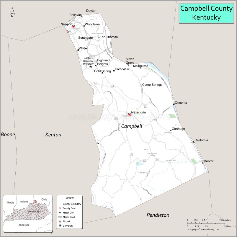
About Campbell County Map, Kentucky: The map showing the county boundary, county seat, major cities, highways, water bodies and neighbouring counties.
More Kentucky Maps & Info
Map of Campbell County, Kentucky
"Campbell County is a county located in the U.S. state of Kentucky. It's county seat is Alexandria and Newport. As per 2020 census, the population of Campbell County is 93050 people and population density is square miles. According to the United States Census Bureau, the county has a total area of 152 sq mi (394 km2). Campbell County was established on 1794."
Campbell County Facts
| Continent | North America |
| Country | United States |
| State | Kentucky |
| County Seat | Alexandria and Newport |
| Largest City/Town | Fort Thomas |
| Established | 1794 |
| Total Area | 159 sq mi (412 sq km) |
| Land Area | 151 sq mi (391 sq km) |
| Water Area | 8 sq mi (21 sq km) |
| Population | 93,076 (Census 2020) |
| Population Density | 615 people per sq mi |
| Time Zone | Eastern Time Zone (ET) |
| Major Highways | Interstate 471, Interstate 275, U.S. Route 27, Kentucky Route 9, Kentucky Route 8 |
| Major Rivers | Ohio River, Licking River |
| Neighboring Counties | Kenton County, Pendleton County, Hamilton County (OH), Clermont County (OH) |
| Famous For | Northern Kentucky river cities, Newport Aquarium, historic neighborhoods, and Cincinnati metropolitan area |
| Top Attractions | Newport Aquarium, Newport on the Levee, AJ Jolly Park, Devou Park nearby area, Riverfront districts |
| Official Website | Official Website |
About Campbell County, Kentucky
Campbell County is located in northern Kentucky along the Ohio River across from Cincinnati, Ohio, and was established in 1794 as one of Kentucky’s earliest counties. The county seats are Alexandria and Newport, while Fort Thomas is the largest city in the county. Campbell County is known for its riverfront communities, historic districts, recreation parks, and strong economic ties to the Cincinnati metropolitan area. :contentReference[oaicite:0]{index=0}
Cities and Communities in Campbell County, Kentucky
| City/Town | Population | Latitude & Longitude |
|---|---|---|
| Alexandria (county seat) | 10,000+ | 38.9595°N, 84.3874°W |
| Newport (county seat) | 15,000+ | 39.0889°N, 84.4958°W |
| Fort Thomas | 16,000+ | 39.0751°N, 84.4472°W |
| Bellevue | 5,800+ | 39.1064°N, 84.4777°W |
| Highland Heights | 6,900+ | 39.0331°N, 84.4519°W |
| Southgate | 3,700+ | 39.0715°N, 84.4724°W |
| Wilder | 3,200+ | 39.0556°N, 84.4869°W |
| California | 80+ | 38.9167°N, 84.2635°W |
Best Golf Courses in Campbell County, Kentucky
| Golf Course | Location | Latitude & Longitude |
|---|---|---|
| AJ Jolly Golf Course | Alexandria | 38.9620°N, 84.3768°W |
| Hickory Sticks Golf Club | Wilder | 39.0215°N, 84.4769°W |
| Fort Mitchell Country Club Nearby Area | Fort Mitchell | 39.0470°N, 84.5621°W |
| Devou Golf Course Nearby Area | Covington | 39.0719°N, 84.5380°W |
What are Major Roads and Highways in Campbell County
Major highways provide direct access to Cincinnati and the greater Northern Kentucky region.
- Interstate 471 - major interstate connecting Newport and Highland Heights with downtown Cincinnati
- Interstate 275 - beltway route serving northern Kentucky suburbs and regional traffic
- U.S. Route 27 - important north-south corridor through Alexandria and Highland Heights
- Kentucky Route 9 (AA Highway) - connector route linking Campbell County with northeastern Kentucky
- Kentucky Route 8 - scenic river road following the Ohio River communities
Neighboring Counties of Campbell County
- Kenton County (west)
- Pendleton County (south)
- Hamilton County, Ohio (northwest)
- Clermont County, Ohio (northeast)
What are Top Attractions in Campbell County, Kentucky
The county features riverfront entertainment districts, parks, museums, and outdoor recreation.
| Main Sight Name | City | Famous For |
|---|---|---|
| Newport Aquarium | Newport | Marine exhibits and family attractions |
| Newport on the Levee | Newport | Dining, shopping, and riverfront entertainment |
| AJ Jolly Park | Alexandria | Lake recreation, camping, and golf |
| Riverfront District | Bellevue-Newport Area | Ohio River views and entertainment venues |
| Northern Kentucky University | Highland Heights | University campus and cultural events |
| Fort Thomas Historic District | Fort Thomas | Historic homes and military heritage |
| Purple People Bridge | Newport | Pedestrian bridge connecting Kentucky and Ohio |
| Campbell County Courthouse | Alexandria | Historic county government building |
| World Peace Bell Nearby Area | Newport Area | Large swinging bell and riverfront landmark |
| Devou Park Nearby Area | Covington Area | Scenic overlooks and outdoor recreation |
Distance from Campbell County to Nearby Cities
The following distances are measured by road (driving).
- Alexandria to Cincinnati, Ohio - 15 mi (24 km)
- Alexandria to Covington, Kentucky - 13 mi (21 km)
- Alexandria to Lexington, Kentucky - 82 mi (132 km)
- Alexandria to Louisville, Kentucky - 101 mi (163 km)
- Alexandria to Frankfort, Kentucky - 77 mi (124 km)
- Alexandria to Columbus, Ohio - 123 mi (198 km)
- Alexandria to Dayton, Ohio - 61 mi (98 km)
- Alexandria to Indianapolis, Indiana - 116 mi (187 km)
- Alexandria to Huntington, West Virginia - 143 mi (230 km)
- Alexandria to Nashville, Tennessee - 273 mi (439 km)
- Alexandria to Chicago, Illinois - 300 mi (483 km)
- Alexandria to St. Louis, Missouri - 356 mi (573 km)
References
- Campbell County Official Website
- Campbell County, Kentucky - Wikipedia
- U.S. Census Bureau QuickFacts
- Northern Kentucky and Cincinnati Tourism
- Explore Kentucky History - Campbell County
- Adair County Map
- Allen County Map
- Anderson County Map
- Ballard County Map
- Barren County Map
- Bath County Map
- Bell County Map
- Boone County Map
- Bourbon County Map
- Boyd County Map
- Boyle County Map
- Bracken County Map
- Breathitt County Map
- Breckinridge County Map
- Bullitt County Map
- Butler County Map
- Caldwell County Map
- Calloway County Map
- Campbell County Map
- Carlisle County Map
- Carroll County Map
- Carter County Map
- Casey County Map
- Christian County Map
- Clark County Map
- Clay County Map
- Clinton County Map
- Crittenden County Map
- Cumberland County Map
- Daviess County Map
- Edmonson County Map
- Elliott County Map
- Estill County Map
- Fayette County Map
- Fleming County Map
- Floyd County Map
- Franklin County Map
- Fulton County Map
- Gallatin County Map
- Garrard County Map
- Grant County Map
- Graves County Map
- Grayson County Map
- Green County Map
- Greenup County Map
- Hancock County Map
- Hardin County Map
- Harlan County Map
- Harrison County Map
- Hart County Map
- Henderson County Map
- Henry County Map
- Hickman County Map
- Hopkins County Map
- Jackson County Map
- Jefferson County Map
- Jessamine County Map
- Johnson County Map
- Kenton County Map
- Knott County Map
- Knox County Map
- LaRue County Map
- Laurel County Map
- Lawrence County Map
- Lee County Map
- Leslie County Map
- Letcher County Map
- Lewis County Map
- Lincoln County Map
- Livingston County Map
- Logan County Map
- Lyon County Map
- McCracken County Map
- McCreary County Map
- McLean County Map
- Madison County Map
- Magoffin County Map
- Marion County Map
- Marshall County Map
- Martin County Map
- Mason County Map
- Meade County Map
- Menifee County Map
- Mercer County Map
- Metcalfe County Map
- Monroe County Map
- Montgomery County Map
- Morgan County Map
- Muhlenberg County Map
- Nelson County Map
- Nicholas County Map
- Ohio County Map
- Oldham County Map
- Owen County Map
- Owsley County Map
- Pendleton County Map
- Perry County Map
- Pike County Map
- Powell County Map
- Pulaski County Map
- Robertson County Map
- Rockcastle County Map
- Rowan County Map
- Russell County Map
- Scott County Map
- Shelby County Map
- Simpson County Map
- Spencer County Map
- Taylor County Map
- Todd County Map
- Trigg County Map
- Trimble County Map
- Union County Map
- Warren County Map
- Washington County Map
- Wayne County Map
- Webster County Map
- Whitley County Map
- Wolfe County Map
- Woodford County Map
- Alabama Counties
- Alaska boroughs
- Arizona Counties
- Arkansas Counties
- California County Map
- Colorado Counties
- Connecticut Counties
- Delaware Counties
- Florida County Map
- Georgia County Map
- Hawaii Counties
- Idaho Counties
- Illinois Counties
- Indiana Counties
- Iowa Counties
- Kansas Counties
- Kentucky Counties
- Louisiana Counties
- Maine Counties
- Maryland Counties
- Massachusetts Counties
- Michigan County Map
- Minnesota Counties
- Mississippi Counties
- Missouri Counties
- Montana Counties
- Nebraska Counties
- Nevada Counties
- New York Counties
- New Hampshire Counties
- New Jersey Counties
- New Mexico Counties
- North Carolina Counties
- North Dakota Counties
- Ohio County Map
- Oklahoma Counties
- Oregon Counties
- Pennsylvania Counties
- Rhode Island Counties
- South Carolina Counties
- South Dakota Counties
- Map of Tennessee
- Texas County Map
- Utah Counties
- Vermont Counties
- Virginia Counties
- Washington Counties
- West Virginia Counties
- Wisconsin Counties
- Wyoming Counties