Map of Fayette County - Fayette County is a county located in the U.S. state of Kentucky. Fayette County Map showing cities, highways, important places and water bodies. Get Where is Fayette County located in the map, major cities in Fayette county, population, areas, and places of interest.
Map of Fayette County, Kentucky
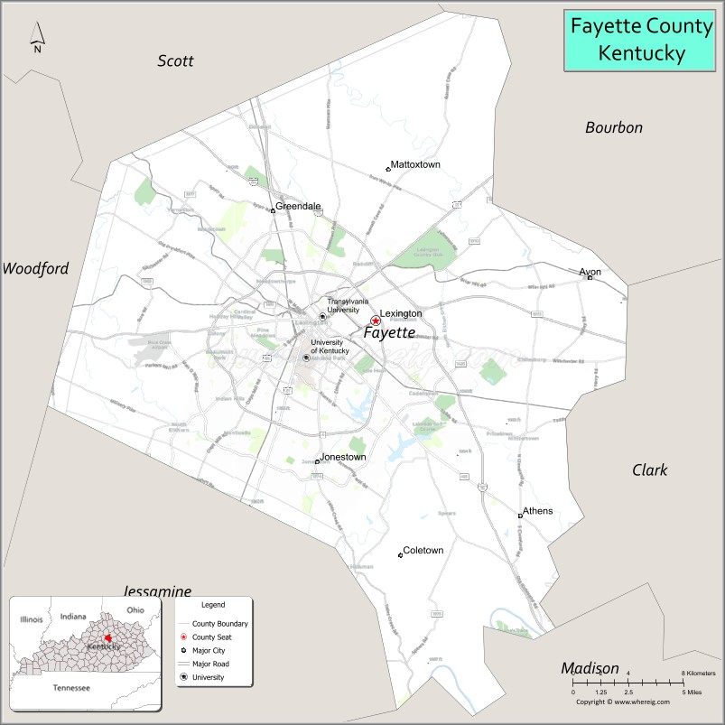
About Fayette County Map, Kentucky: The map showing the county boundary, county seat, major cities, highways, water bodies and neighbouring counties.
More Kentucky Maps & Info
Map of Fayette County, Kentucky
Fayette County is a county located in the U.S. state of Kentucky. It's county seat is Lexington. As per 2020 census, the population of Fayette County is 321793 people and population density is square miles. According to the United States Census Bureau, the county has a total area of 284 sq mi (736 km2). Fayette County was established on 1780.
Fayette County Facts
| Continent | North America |
| Country | United States |
| State | Kentucky |
| County Seat | Lexington |
| Largest City/Town | Lexington |
| Established | 1780 |
| Total Area | 286 sq mi (741 sq km) |
| Land Area | 284 sq mi (736 sq km) |
| Water Area | 1.9 sq mi (5 sq km) |
| Population | 322,570 (Census 2020) |
| Population Density | 1,136 people per sq mi |
| Time Zone | Eastern Time Zone (ET) |
| Major Highways | Interstate 64, Interstate 75, U.S. Route 25, U.S. Route 27, New Circle Road |
| Major Rivers | Kentucky River nearby area, Elkhorn Creek |
| Neighboring Counties | Scott County, Bourbon County, Clark County, Madison County, Jessamine County, Woodford County |
| Famous For | Horse farms, the University of Kentucky, bourbon culture, and Lexington's Bluegrass heritage |
| Top Attractions | Kentucky Horse Park, Keeneland Race Course, University of Kentucky, Mary Todd Lincoln House, Lexington Distillery District |
| Official Website | Official Website |
About Fayette County, Kentucky
Fayette County is located in central Kentucky within the Bluegrass region and was established in 1780 as one of the original counties of Kentucky. The county seat and largest city is Lexington, often called the "Horse Capital of the World." Fayette County is known for its world-famous horse farms, bourbon culture, historic landmarks, higher education institutions, and vibrant arts and dining scene. ([en.wikipedia.org](https://en.wikipedia.org/wiki/Fayette_County%2C_Kentucky?utm_source=chatgpt.com))
Cities and Communities in Fayette County, Kentucky
| City/Town | Population | Latitude & Longitude |
|---|---|---|
| Lexington (county seat) | 320,000+ | 38.0406°N, 84.5037°W |
| Cadentown | Historic Community | 38.0131°N, 84.4165°W |
| Athens | Historic Community | 38.0202°N, 84.3966°W |
| Spears | Unincorporated | 38.0907°N, 84.4773°W |
| Jonestown | Historic Community | 38.0778°N, 84.4570°W |
| Elkhorn Park Area | Regional Community | 38.0739°N, 84.5202°W |
| Hamburg Area | Commercial District | 38.0247°N, 84.4228°W |
| Masterson Station Area | Residential Community | 38.0889°N, 84.5801°W |
Best Golf Courses in Fayette County, Kentucky
| Golf Course | Location | Latitude & Longitude |
|---|---|---|
| Kearney Hill Golf Links | Lexington | 38.1028°N, 84.5490°W |
| University Club of Kentucky | Lexington | 38.0415°N, 84.4190°W |
| Idle Hour Country Club | Lexington | 38.0270°N, 84.4632°W |
| Greenbrier Golf & Country Club | Lexington | 38.0618°N, 84.5420°W |
What are Major Roads and Highways in Fayette County
Major highways connect Fayette County with Louisville, Cincinnati, eastern Kentucky, and Tennessee.
- Interstate 64 - major east-west interstate connecting Lexington with Louisville and eastern Kentucky
- Interstate 75 - major north-south interstate linking Lexington with Cincinnati and Tennessee
- U.S. Route 25 - regional highway through central Kentucky
- U.S. Route 27 - major corridor connecting Lexington with Nicholasville and northern Kentucky
- New Circle Road - beltway route serving Lexington metropolitan areas
Neighboring Counties of Fayette County
- Scott County (north)
- Bourbon County (northeast)
- Clark County (east)
- Madison County (south)
- Jessamine County (southwest)
- Woodford County (west)
What are Top Attractions in Fayette County, Kentucky
The county offers horse racing attractions, bourbon tourism, museums, historic landmarks, and entertainment districts.
| Main Sight Name | City | Famous For |
|---|---|---|
| Kentucky Horse Park | Lexington | Horse museums, equestrian events, and horse farm tours |
| Keeneland Race Course | Lexington | Historic horse racing and thoroughbred auctions |
| University of Kentucky | Lexington | Major public university and Wildcats athletics |
| Mary Todd Lincoln House | Lexington | Historic home of Abraham Lincoln's wife |
| Lexington Distillery District | Lexington | Bourbon distilleries, restaurants, and nightlife |
| Rupp Arena | Lexington | Basketball games and entertainment events |
| Ashland - The Henry Clay Estate | Lexington | Historic estate and gardens |
| The Arboretum | Lexington | Botanical gardens and walking trails |
| Downtown Lexington | Lexington | Restaurants, arts venues, and shopping districts |
| Bluegrass Scenic Horse Farms | Countywide | Rolling pastures and world-famous horse breeding farms |
Distance from Fayette County to Nearby Cities
The following distances are measured by road (driving).
- Lexington to Louisville, Kentucky - 79 mi (127 km)
- Lexington to Cincinnati, Ohio - 83 mi (134 km)
- Lexington to Frankfort, Kentucky - 29 mi (47 km)
- Lexington to Richmond, Kentucky - 26 mi (42 km)
- Lexington to Knoxville, Tennessee - 173 mi (278 km)
- Lexington to Nashville, Tennessee - 215 mi (346 km)
- Lexington to Columbus, Ohio - 189 mi (304 km)
- Lexington to Indianapolis, Indiana - 176 mi (283 km)
- Lexington to Huntington, West Virginia - 136 mi (219 km)
- Lexington to St. Louis, Missouri - 365 mi (587 km)
- Lexington to Chicago, Illinois - 377 mi (607 km)
- Lexington to Atlanta, Georgia - 381 mi (613 km)
References
- Lexington-Fayette Urban County Government
- Fayette County, Kentucky - Wikipedia
- U.S. Census Bureau QuickFacts
- VisitLEX Tourism
- Kentucky Atlas and Gazetteer
- Adair County Map
- Allen County Map
- Anderson County Map
- Ballard County Map
- Barren County Map
- Bath County Map
- Bell County Map
- Boone County Map
- Bourbon County Map
- Boyd County Map
- Boyle County Map
- Bracken County Map
- Breathitt County Map
- Breckinridge County Map
- Bullitt County Map
- Butler County Map
- Caldwell County Map
- Calloway County Map
- Campbell County Map
- Carlisle County Map
- Carroll County Map
- Carter County Map
- Casey County Map
- Christian County Map
- Clark County Map
- Clay County Map
- Clinton County Map
- Crittenden County Map
- Cumberland County Map
- Daviess County Map
- Edmonson County Map
- Elliott County Map
- Estill County Map
- Fayette County Map
- Fleming County Map
- Floyd County Map
- Franklin County Map
- Fulton County Map
- Gallatin County Map
- Garrard County Map
- Grant County Map
- Graves County Map
- Grayson County Map
- Green County Map
- Greenup County Map
- Hancock County Map
- Hardin County Map
- Harlan County Map
- Harrison County Map
- Hart County Map
- Henderson County Map
- Henry County Map
- Hickman County Map
- Hopkins County Map
- Jackson County Map
- Jefferson County Map
- Jessamine County Map
- Johnson County Map
- Kenton County Map
- Knott County Map
- Knox County Map
- LaRue County Map
- Laurel County Map
- Lawrence County Map
- Lee County Map
- Leslie County Map
- Letcher County Map
- Lewis County Map
- Lincoln County Map
- Livingston County Map
- Logan County Map
- Lyon County Map
- McCracken County Map
- McCreary County Map
- McLean County Map
- Madison County Map
- Magoffin County Map
- Marion County Map
- Marshall County Map
- Martin County Map
- Mason County Map
- Meade County Map
- Menifee County Map
- Mercer County Map
- Metcalfe County Map
- Monroe County Map
- Montgomery County Map
- Morgan County Map
- Muhlenberg County Map
- Nelson County Map
- Nicholas County Map
- Ohio County Map
- Oldham County Map
- Owen County Map
- Owsley County Map
- Pendleton County Map
- Perry County Map
- Pike County Map
- Powell County Map
- Pulaski County Map
- Robertson County Map
- Rockcastle County Map
- Rowan County Map
- Russell County Map
- Scott County Map
- Shelby County Map
- Simpson County Map
- Spencer County Map
- Taylor County Map
- Todd County Map
- Trigg County Map
- Trimble County Map
- Union County Map
- Warren County Map
- Washington County Map
- Wayne County Map
- Webster County Map
- Whitley County Map
- Wolfe County Map
- Woodford County Map
- Alabama Counties
- Alaska boroughs
- Arizona Counties
- Arkansas Counties
- California County Map
- Colorado Counties
- Connecticut Counties
- Delaware Counties
- Florida County Map
- Georgia County Map
- Hawaii Counties
- Idaho Counties
- Illinois Counties
- Indiana Counties
- Iowa Counties
- Kansas Counties
- Kentucky Counties
- Louisiana Counties
- Maine Counties
- Maryland Counties
- Massachusetts Counties
- Michigan County Map
- Minnesota Counties
- Mississippi Counties
- Missouri Counties
- Montana Counties
- Nebraska Counties
- Nevada Counties
- New York Counties
- New Hampshire Counties
- New Jersey Counties
- New Mexico Counties
- North Carolina Counties
- North Dakota Counties
- Ohio County Map
- Oklahoma Counties
- Oregon Counties
- Pennsylvania Counties
- Rhode Island Counties
- South Carolina Counties
- South Dakota Counties
- Map of Tennessee
- Texas County Map
- Utah Counties
- Vermont Counties
- Virginia Counties
- Washington Counties
- West Virginia Counties
- Wisconsin Counties
- Wyoming Counties