Map of Owsley County - Owsley County is a county located in the U.S. state of Kentucky. Owsley County Map showing cities, highways, important places and water bodies. Get Where is Owsley County located in the map, major cities in Owsley county, population, areas, and places of interest.
Map of Owsley County, Kentucky
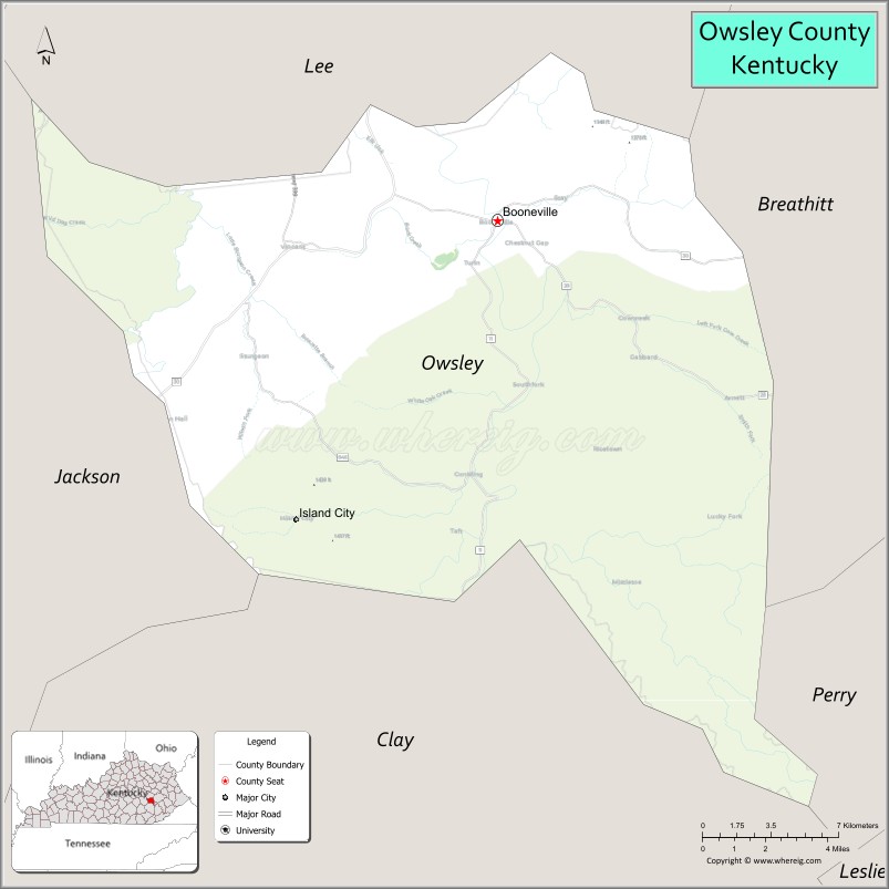
About Owsley County Map, Kentucky: The map showing the county boundary, county seat, major cities, highways, water bodies and neighbouring counties.
More Kentucky Maps & Info
Map of Owsley County, Kentucky
Owsley County is a county located in the U.S. state of Kentucky. It's county seat is Booneville. As per 2020 census, the population of Owsley County is 3953 people and population density is square miles. According to the United States Census Bureau, the county has a total area of 198 sq mi (513 km2). Owsley County was established on 1843.
Owsley County Facts
| Continent | North America |
| Country | United States |
| State | Kentucky |
| County Seat | Booneville |
| Largest City/Town | Booneville |
| Established | 1843 |
| Total Area | 198 sq mi (513 sq km) |
| Land Area | 198 sq mi (513 sq km) |
| Water Area | 0.3 sq mi (1 sq km) |
| Population | 4,051 (Census 2020) |
| Population Density | 20 people per sq mi |
| Time Zone | Eastern Time Zone (ET) |
| Major Highways | Kentucky Route 11, Kentucky Route 28, Kentucky Route 846, Kentucky Route 30 nearby area |
| Major Rivers | South Fork Kentucky River |
| Neighboring Counties | Lee County, Breathitt County, Perry County, Clay County, Jackson County |
| Famous For | Appalachian mountain scenery, Daniel Boone National Forest nearby area, rural Kentucky heritage, and outdoor recreation |
| Top Attractions | Daniel Boone National Forest nearby area, South Fork Kentucky River, Booneville Historic District, Sheltowee Trace Trail nearby area, scenic mountain drives |
| Official Website | Official Website |
About Owsley County, Kentucky
Owsley County is located in southeastern Kentucky within the Appalachian region and was established in 1843. The county seat and largest city is Booneville. Owsley County is known for rugged mountain landscapes, forested valleys, Appalachian traditions, and peaceful rural communities surrounded by eastern Kentucky natural beauty. ([en.wikipedia.org](https://en.wikipedia.org/wiki/Owsley_County%2C_Kentucky?utm_source=chatgpt.com))
Cities and Communities in Owsley County, Kentucky
| City/Town | Population | Latitude & Longitude |
|---|---|---|
| Booneville (county seat) | 100+ | 37.4765°N, 83.6746°W |
| Blake | Rural Community | 37.4932°N, 83.7301°W |
| Travellers Rest | Historic Community | 37.4508°N, 83.6032°W |
| Island City | Mountain Community | 37.4045°N, 83.7125°W |
| Mistletoe | Unincorporated | 37.4217°N, 83.5881°W |
| Ricetown Nearby Area | Regional Community | 37.4229°N, 83.8424°W |
| Sturgeon Nearby Area | Regional Area | 37.5510°N, 83.7193°W |
| Southfork | Rural Area | 37.5075°N, 83.6567°W |
Best Golf Courses in Owsley County, Kentucky
| Golf Course | Location | Latitude & Longitude |
|---|---|---|
| Sag Hollow Golf Club | Nearby Paintsville | 37.7862°N, 82.7875°W |
| Bright Leaf Golf Resort | Nearby Harrodsburg | 37.7425°N, 84.8172°W |
| Sleepy Hollow Golf Course | Nearby Cumberland | 36.9781°N, 82.9884°W |
| Gibson Bay Golf Course | Nearby Richmond | 37.7660°N, 84.3018°W |
What are Major Roads and Highways in Owsley County
Major highways connect Owsley County with eastern Kentucky mountain communities and nearby regional centers.
- Kentucky Route 11 - major north-south route through Booneville and surrounding communities
- Kentucky Route 28 - scenic mountain roadway connecting rural Appalachian areas
- Kentucky Route 846 - regional connector serving local communities and recreation areas
- Kentucky Route 30 nearby area - important east-west corridor through southeastern Kentucky
Neighboring Counties of Owsley County
- Lee County (north)
- Breathitt County (east)
- Perry County (southeast)
- Clay County (southwest)
- Jackson County (west)
What are Top Attractions in Owsley County, Kentucky
The county offers forest recreation, Appalachian scenery, river landscapes, hiking opportunities, and peaceful rural destinations.
| Main Sight Name | City | Famous For |
|---|---|---|
| Daniel Boone National Forest Nearby Area | Regional Area | Camping, hiking, and forest recreation |
| South Fork Kentucky River | Countywide | Fishing, kayaking, and scenic river views |
| Booneville Historic District | Booneville | Historic courthouse and Appalachian heritage |
| Sheltowee Trace Trail Nearby Area | Regional Area | Long-distance hiking and outdoor adventure |
| Scenic Mountain Drives | Countywide | Appalachian landscapes and photography |
| Historic Rural Churches | Countywide | Local traditions and mountain heritage |
| Outdoor Nature Trails | Countywide | Wildlife viewing and hiking recreation |
| Mountain Valley Photography Areas | Countywide | Scenic overlooks and natural beauty |
| Community Heritage Events | Booneville Area | Appalachian traditions and local festivals |
| Forest Recreation Areas | Countywide | Camping and peaceful countryside experiences |
Distance from Owsley County to Nearby Cities
The following distances are measured by road (driving).
- Booneville to Richmond, Kentucky - 58 mi (93 km)
- Booneville to Hazard, Kentucky - 44 mi (71 km)
- Booneville to Lexington, Kentucky - 82 mi (132 km)
- Booneville to Knoxville, Tennessee - 143 mi (230 km)
- Booneville to Louisville, Kentucky - 164 mi (264 km)
- Booneville to Charleston, West Virginia - 165 mi (266 km)
- Booneville to Huntington, West Virginia - 126 mi (203 km)
- Booneville to Cincinnati, Ohio - 165 mi (266 km)
- Booneville to Nashville, Tennessee - 228 mi (367 km)
- Booneville to Columbus, Ohio - 230 mi (370 km)
- Booneville to Indianapolis, Indiana - 258 mi (415 km)
- Booneville to Atlanta, Georgia - 303 mi (488 km)
References
- Owsley County Official Website
- Owsley County, Kentucky - Wikipedia
- U.S. Census Bureau QuickFacts
- Daniel Boone National Forest
- Kentucky Tourism
- Adair County Map
- Allen County Map
- Anderson County Map
- Ballard County Map
- Barren County Map
- Bath County Map
- Bell County Map
- Boone County Map
- Bourbon County Map
- Boyd County Map
- Boyle County Map
- Bracken County Map
- Breathitt County Map
- Breckinridge County Map
- Bullitt County Map
- Butler County Map
- Caldwell County Map
- Calloway County Map
- Campbell County Map
- Carlisle County Map
- Carroll County Map
- Carter County Map
- Casey County Map
- Christian County Map
- Clark County Map
- Clay County Map
- Clinton County Map
- Crittenden County Map
- Cumberland County Map
- Daviess County Map
- Edmonson County Map
- Elliott County Map
- Estill County Map
- Fayette County Map
- Fleming County Map
- Floyd County Map
- Franklin County Map
- Fulton County Map
- Gallatin County Map
- Garrard County Map
- Grant County Map
- Graves County Map
- Grayson County Map
- Green County Map
- Greenup County Map
- Hancock County Map
- Hardin County Map
- Harlan County Map
- Harrison County Map
- Hart County Map
- Henderson County Map
- Henry County Map
- Hickman County Map
- Hopkins County Map
- Jackson County Map
- Jefferson County Map
- Jessamine County Map
- Johnson County Map
- Kenton County Map
- Knott County Map
- Knox County Map
- LaRue County Map
- Laurel County Map
- Lawrence County Map
- Lee County Map
- Leslie County Map
- Letcher County Map
- Lewis County Map
- Lincoln County Map
- Livingston County Map
- Logan County Map
- Lyon County Map
- McCracken County Map
- McCreary County Map
- McLean County Map
- Madison County Map
- Magoffin County Map
- Marion County Map
- Marshall County Map
- Martin County Map
- Mason County Map
- Meade County Map
- Menifee County Map
- Mercer County Map
- Metcalfe County Map
- Monroe County Map
- Montgomery County Map
- Morgan County Map
- Muhlenberg County Map
- Nelson County Map
- Nicholas County Map
- Ohio County Map
- Oldham County Map
- Owen County Map
- Owsley County Map
- Pendleton County Map
- Perry County Map
- Pike County Map
- Powell County Map
- Pulaski County Map
- Robertson County Map
- Rockcastle County Map
- Rowan County Map
- Russell County Map
- Scott County Map
- Shelby County Map
- Simpson County Map
- Spencer County Map
- Taylor County Map
- Todd County Map
- Trigg County Map
- Trimble County Map
- Union County Map
- Warren County Map
- Washington County Map
- Wayne County Map
- Webster County Map
- Whitley County Map
- Wolfe County Map
- Woodford County Map
- Alabama Counties
- Alaska boroughs
- Arizona Counties
- Arkansas Counties
- California County Map
- Colorado Counties
- Connecticut Counties
- Delaware Counties
- Florida County Map
- Georgia County Map
- Hawaii Counties
- Idaho Counties
- Illinois Counties
- Indiana Counties
- Iowa Counties
- Kansas Counties
- Kentucky Counties
- Louisiana Counties
- Maine Counties
- Maryland Counties
- Massachusetts Counties
- Michigan County Map
- Minnesota Counties
- Mississippi Counties
- Missouri Counties
- Montana Counties
- Nebraska Counties
- Nevada Counties
- New York Counties
- New Hampshire Counties
- New Jersey Counties
- New Mexico Counties
- North Carolina Counties
- North Dakota Counties
- Ohio County Map
- Oklahoma Counties
- Oregon Counties
- Pennsylvania Counties
- Rhode Island Counties
- South Carolina Counties
- South Dakota Counties
- Map of Tennessee
- Texas County Map
- Utah Counties
- Vermont Counties
- Virginia Counties
- Washington Counties
- West Virginia Counties
- Wisconsin Counties
- Wyoming Counties