Map of Crittenden County - Crittenden County is a county located in the U.S. state of Kentucky. Crittenden County Map showing cities, highways, important places and water bodies. Get Where is Crittenden County located in the map, major cities in Crittenden county, population, areas, and places of interest.
Map of Crittenden County, Kentucky
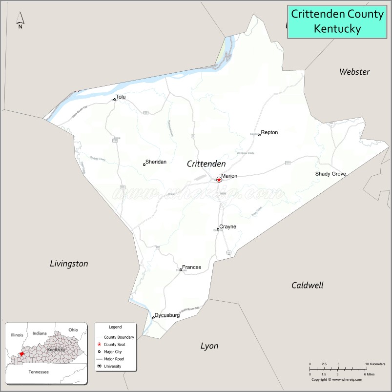
About Crittenden County Map, Kentucky: The map showing the county boundary, county seat, major cities, highways, water bodies and neighbouring counties.
More Kentucky Maps & Info
Map of Crittenden County, Kentucky
Crittenden County is a county located in the U.S. state of Kentucky. It's county seat is Marion. As per 2020 census, the population of Crittenden County is 8947 people and population density is square miles. According to the United States Census Bureau, the county has a total area of 362 sq mi (938 km2). Crittenden County was established on 1842.
Crittenden County Facts
| Continent | North America |
| Country | United States |
| State | Kentucky |
| County Seat | Marion |
| Largest City/Town | Marion |
| Established | 1842 |
| Total Area | 371 sq mi (961 sq km) |
| Land Area | 360 sq mi (932 sq km) |
| Water Area | 11 sq mi (28 sq km) |
| Population | 8,990 (Census 2020) |
| Population Density | 25 people per sq mi |
| Time Zone | Central Time Zone (CT) |
| Major Highways | U.S. Route 60, U.S. Route 641, Kentucky Route 91, Interstate 69 nearby area |
| Major Rivers | Tradewater River, Ohio River nearby area |
| Neighboring Counties | Union County, Livingston County, Caldwell County, Webster County, Hardin County (IL) |
| Famous For | Western Kentucky coal mining history, Cave-In-Rock Ferry nearby area, outdoor recreation, and rural landscapes |
| Top Attractions | Cave-In-Rock Ferry nearby area, Big Rivers Wildlife Management Area, Marion Historic District, Tradewater River scenery, Ben E. Clement Mineral Museum |
| Official Website | Official Website |
About Crittenden County, Kentucky
Crittenden County is located in western Kentucky within the Pennyrile region and was established in 1842. The county seat and largest city is Marion. Crittenden County is known for its coal mining heritage, scenic rolling countryside, ferry crossings along the Ohio River region, and outdoor recreation opportunities. ([en.wikipedia.org](https://en.wikipedia.org/wiki/Crittenden_County%2C_Kentucky?utm_source=chatgpt.com))
Cities and Communities in Crittenden County, Kentucky
| City/Town | Population | Latitude & Longitude |
|---|---|---|
| Marion (county seat) | 2,900+ | 37.3362°N, 88.0814°W |
| Dycusburg | 350+ | 37.1420°N, 88.0167°W |
| Salem Nearby Area | Regional Community | 37.2642°N, 88.2456°W |
| Tolu | Historic Community | 37.4306°N, 88.0484°W |
| Mexico | Unincorporated | 37.3661°N, 87.9823°W |
| View | Unincorporated | 37.3125°N, 88.1620°W |
| West Fork | Unincorporated | 37.2784°N, 88.1125°W |
| Crayne | Historic Mining Community | 37.3008°N, 87.9991°W |
Best Golf Courses in Crittenden County, Kentucky
| Golf Course | Location | Latitude & Longitude |
|---|---|---|
| Marion Country Club | Marion | 37.3348°N, 88.0944°W |
| Mineral Mound Golf Course | Nearby Eddyville | 37.0634°N, 88.0739°W |
| Calvert City Golf & Country Club | Nearby Calvert City | 37.0437°N, 88.3465°W |
| Madisonville Country Club | Nearby Madisonville | 37.3397°N, 87.5115°W |
What are Major Roads and Highways in Crittenden County
Major highways connect Crittenden County with western Kentucky cities and the Ohio River region.
- U.S. Route 60 - major east-west highway through Marion and western Kentucky
- U.S. Route 641 - important north-south route linking the county with Kentucky Lake and Tennessee
- Kentucky Route 91 - regional connector serving rural communities and farmland areas
- Interstate 69 nearby area - transportation corridor providing regional interstate access
Neighboring Counties of Crittenden County
- Union County (northwest)
- Livingston County (west)
- Caldwell County (south)
- Webster County (east)
- Hardin County, Illinois (north across the Ohio River)
What are Top Attractions in Crittenden County, Kentucky
The county features river landscapes, historic mining heritage, and outdoor recreation areas.
| Main Sight Name | City | Famous For |
|---|---|---|
| Cave-In-Rock Ferry Nearby Area | Tolu Area | Historic Ohio River ferry crossing |
| Big Rivers Wildlife Management Area | Countywide | Hunting, wildlife observation, and nature trails |
| Marion Historic District | Marion | Historic downtown buildings and local shops |
| Tradewater River Scenic Area | Countywide | Fishing, kayaking, and scenic landscapes |
| Ben E. Clement Mineral Museum | Marion | Mineral and mining history exhibits |
| Crittenden County Courthouse | Marion | Historic county landmark |
| Ohio River Scenic Views | Northern County | River photography and boating recreation |
| Historic Coal Mining Communities | Countywide | Regional mining heritage and history |
| Dycusburg River Area | Dycusburg | Fishing and countryside scenery |
| Rural Scenic Drives | Countywide | Rolling hills and western Kentucky farmland views |
Distance from Crittenden County to Nearby Cities
The following distances are measured by road (driving).
- Marion to Paducah, Kentucky - 52 mi (84 km)
- Marion to Evansville, Indiana - 72 mi (116 km)
- Marion to Madisonville, Kentucky - 44 mi (71 km)
- Marion to Owensboro, Kentucky - 71 mi (114 km)
- Marion to Hopkinsville, Kentucky - 68 mi (109 km)
- Marion to Nashville, Tennessee - 145 mi (233 km)
- Marion to Louisville, Kentucky - 183 mi (295 km)
- Marion to St. Louis, Missouri - 181 mi (291 km)
- Marion to Memphis, Tennessee - 191 mi (307 km)
- Marion to Lexington, Kentucky - 225 mi (362 km)
- Marion to Indianapolis, Indiana - 210 mi (338 km)
- Marion to Cincinnati, Ohio - 274 mi (441 km)
References
- Crittenden County Official Website
- Crittenden County, Kentucky - Wikipedia
- U.S. Census Bureau QuickFacts
- Kentucky Atlas and Gazetteer
- Kentucky Department of Fish and Wildlife Resources
- Adair County Map
- Allen County Map
- Anderson County Map
- Ballard County Map
- Barren County Map
- Bath County Map
- Bell County Map
- Boone County Map
- Bourbon County Map
- Boyd County Map
- Boyle County Map
- Bracken County Map
- Breathitt County Map
- Breckinridge County Map
- Bullitt County Map
- Butler County Map
- Caldwell County Map
- Calloway County Map
- Campbell County Map
- Carlisle County Map
- Carroll County Map
- Carter County Map
- Casey County Map
- Christian County Map
- Clark County Map
- Clay County Map
- Clinton County Map
- Crittenden County Map
- Cumberland County Map
- Daviess County Map
- Edmonson County Map
- Elliott County Map
- Estill County Map
- Fayette County Map
- Fleming County Map
- Floyd County Map
- Franklin County Map
- Fulton County Map
- Gallatin County Map
- Garrard County Map
- Grant County Map
- Graves County Map
- Grayson County Map
- Green County Map
- Greenup County Map
- Hancock County Map
- Hardin County Map
- Harlan County Map
- Harrison County Map
- Hart County Map
- Henderson County Map
- Henry County Map
- Hickman County Map
- Hopkins County Map
- Jackson County Map
- Jefferson County Map
- Jessamine County Map
- Johnson County Map
- Kenton County Map
- Knott County Map
- Knox County Map
- LaRue County Map
- Laurel County Map
- Lawrence County Map
- Lee County Map
- Leslie County Map
- Letcher County Map
- Lewis County Map
- Lincoln County Map
- Livingston County Map
- Logan County Map
- Lyon County Map
- McCracken County Map
- McCreary County Map
- McLean County Map
- Madison County Map
- Magoffin County Map
- Marion County Map
- Marshall County Map
- Martin County Map
- Mason County Map
- Meade County Map
- Menifee County Map
- Mercer County Map
- Metcalfe County Map
- Monroe County Map
- Montgomery County Map
- Morgan County Map
- Muhlenberg County Map
- Nelson County Map
- Nicholas County Map
- Ohio County Map
- Oldham County Map
- Owen County Map
- Owsley County Map
- Pendleton County Map
- Perry County Map
- Pike County Map
- Powell County Map
- Pulaski County Map
- Robertson County Map
- Rockcastle County Map
- Rowan County Map
- Russell County Map
- Scott County Map
- Shelby County Map
- Simpson County Map
- Spencer County Map
- Taylor County Map
- Todd County Map
- Trigg County Map
- Trimble County Map
- Union County Map
- Warren County Map
- Washington County Map
- Wayne County Map
- Webster County Map
- Whitley County Map
- Wolfe County Map
- Woodford County Map
- Alabama Counties
- Alaska boroughs
- Arizona Counties
- Arkansas Counties
- California County Map
- Colorado Counties
- Connecticut Counties
- Delaware Counties
- Florida County Map
- Georgia County Map
- Hawaii Counties
- Idaho Counties
- Illinois Counties
- Indiana Counties
- Iowa Counties
- Kansas Counties
- Kentucky Counties
- Louisiana Counties
- Maine Counties
- Maryland Counties
- Massachusetts Counties
- Michigan County Map
- Minnesota Counties
- Mississippi Counties
- Missouri Counties
- Montana Counties
- Nebraska Counties
- Nevada Counties
- New York Counties
- New Hampshire Counties
- New Jersey Counties
- New Mexico Counties
- North Carolina Counties
- North Dakota Counties
- Ohio County Map
- Oklahoma Counties
- Oregon Counties
- Pennsylvania Counties
- Rhode Island Counties
- South Carolina Counties
- South Dakota Counties
- Map of Tennessee
- Texas County Map
- Utah Counties
- Vermont Counties
- Virginia Counties
- Washington Counties
- West Virginia Counties
- Wisconsin Counties
- Wyoming Counties