Map of Casey County - Casey County is a county located in the U.S. state of Kentucky. Casey County Map showing cities, highways, important places and water bodies. Get Where is Casey County located in the map, major cities in Casey county, population, areas, and places of interest.
Map of Casey County, Kentucky
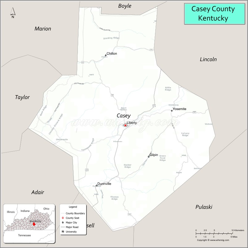
About Casey County Map, Kentucky: The map showing the county boundary, county seat, major cities, highways, water bodies and neighbouring counties.
More Kentucky Maps & Info
Map of Casey County, Kentucky
Casey County is a county located in the U.S. state of Kentucky. It's county seat is Liberty. As per 2020 census, the population of Casey County is 15866 people and population density is square miles. According to the United States Census Bureau, the county has a total area of 446 sq mi (1,155 km2). Casey County was established on 1806.
Casey County Facts
| Continent | North America |
| Country | United States |
| State | Kentucky |
| County Seat | Liberty |
| Largest City/Town | Liberty |
| Established | 1806 |
| Total Area | 446 sq mi (1,155 sq km) |
| Land Area | 445 sq mi (1,152 sq km) |
| Water Area | 1.5 sq mi (4 sq km) |
| Population | 15,941 (Census 2020) |
| Population Density | 36 people per sq mi |
| Time Zone | Eastern Time Zone (ET) |
| Major Highways | U.S. Route 127, Kentucky Route 70, Kentucky Route 80, Kentucky Route 501 |
| Major Rivers | Green River, Big South Fork River nearby area |
| Neighboring Counties | Lincoln County, Pulaski County, Russell County, Taylor County, Boyle County, Adair County |
| Famous For | Amish communities, rolling farmland, Green River region, and rural Kentucky heritage |
| Top Attractions | Liberty Bell replica, Green River scenic areas, Amish country drives, Central Kentucky Ag/Expo Center, historic Liberty downtown |
| Official Website | Official Website |
About Casey County, Kentucky
Casey County is located in south-central Kentucky and was established in 1806. The county seat and largest city is Liberty. Casey County is known for its scenic countryside, Amish communities, agriculture, and traditional rural culture in central Kentucky. ([en.wikipedia.org](https://en.wikipedia.org/wiki/Casey_County%2C_Kentucky?utm_source=chatgpt.com))
Cities and Communities in Casey County, Kentucky
| City/Town | Population | Latitude & Longitude |
|---|---|---|
| Liberty (county seat) | 2,100+ | 37.3187°N, 84.9397°W |
| Dunnville | Unincorporated | 37.1953°N, 85.0032°W |
| Middleburg | Historic Community | 37.3512°N, 84.8329°W |
| Windsor | Unincorporated | 37.1648°N, 84.8849°W |
| Bethelridge | Unincorporated | 37.2770°N, 84.7638°W |
| Yosemite | Unincorporated | 37.3085°N, 85.1170°W |
| Clementsville | Unincorporated | 37.2554°N, 84.8514°W |
| Phil | Historic Community | 37.3841°N, 84.9723°W |
Best Golf Courses in Casey County, Kentucky
| Golf Course | Location | Latitude & Longitude |
|---|---|---|
| Liberty Country Club | Liberty | 37.3160°N, 84.9438°W |
| Eagle's Nest Country Club | Nearby Somerset | 37.1064°N, 84.6328°W |
| Bright Leaf Golf Resort | Nearby Harrodsburg | 37.7425°N, 84.9041°W |
| Lake Cumberland Golf Club | Nearby Russell Springs | 37.0502°N, 85.0609°W |
What are Major Roads and Highways in Casey County
Major highways connect Casey County with south-central Kentucky communities and regional cities.
- U.S. Route 127 - major north-south route through Liberty connecting Danville and Russell Springs
- Kentucky Route 70 - east-west route serving Liberty and rural communities
- Kentucky Route 80 - important regional highway connecting Somerset and Columbia areas
- Kentucky Route 501 - scenic connector through rolling countryside and farming areas
Neighboring Counties of Casey County
- Lincoln County (east)
- Pulaski County (south)
- Russell County (southwest)
- Taylor County (west)
- Boyle County (north)
- Adair County (west)
What are Top Attractions in Casey County, Kentucky
The county offers scenic countryside, Amish culture, and outdoor recreation opportunities.
| Main Sight Name | City | Famous For |
|---|---|---|
| Liberty Bell Replica | Liberty | Replica of the famous Liberty Bell landmark |
| Green River Scenic Area | Countywide | Fishing, kayaking, and countryside views |
| Amish Country Scenic Drives | Countywide | Traditional Amish farms and handmade crafts |
| Central Kentucky Ag/Expo Center | Liberty | Agricultural fairs and local events |
| Historic Downtown Liberty | Liberty | Historic buildings and local shops |
| Casey County Apple Festival | Liberty | Annual festival celebrating local culture |
| Rural Covered Bridges Nearby Area | Regional Area | Historic bridge photography and scenic drives |
| Lake Cumberland Nearby Area | Regional Area | Boating and outdoor recreation |
| Casey County Courthouse | Liberty | Historic county landmark |
| Rolling Farmland Scenic Routes | Countywide | Picturesque Kentucky countryside landscapes |
Distance from Casey County to Nearby Cities
The following distances are measured by road (driving).
- Liberty to Somerset, Kentucky - 35 mi (56 km)
- Liberty to Danville, Kentucky - 38 mi (61 km)
- Liberty to Lexington, Kentucky - 82 mi (132 km)
- Liberty to Louisville, Kentucky - 111 mi (179 km)
- Liberty to Bowling Green, Kentucky - 96 mi (154 km)
- Liberty to Frankfort, Kentucky - 77 mi (124 km)
- Liberty to Columbia, Kentucky - 32 mi (51 km)
- Liberty to Richmond, Kentucky - 57 mi (92 km)
- Liberty to Nashville, Tennessee - 177 mi (285 km)
- Liberty to Knoxville, Tennessee - 147 mi (237 km)
- Liberty to Cincinnati, Ohio - 157 mi (253 km)
- Liberty to Chattanooga, Tennessee - 225 mi (362 km)
References
- Casey County Official Website
- Casey County, Kentucky - Wikipedia
- U.S. Census Bureau QuickFacts
- Kentucky Atlas and Gazetteer
- Kentucky Tourism
- Adair County Map
- Allen County Map
- Anderson County Map
- Ballard County Map
- Barren County Map
- Bath County Map
- Bell County Map
- Boone County Map
- Bourbon County Map
- Boyd County Map
- Boyle County Map
- Bracken County Map
- Breathitt County Map
- Breckinridge County Map
- Bullitt County Map
- Butler County Map
- Caldwell County Map
- Calloway County Map
- Campbell County Map
- Carlisle County Map
- Carroll County Map
- Carter County Map
- Casey County Map
- Christian County Map
- Clark County Map
- Clay County Map
- Clinton County Map
- Crittenden County Map
- Cumberland County Map
- Daviess County Map
- Edmonson County Map
- Elliott County Map
- Estill County Map
- Fayette County Map
- Fleming County Map
- Floyd County Map
- Franklin County Map
- Fulton County Map
- Gallatin County Map
- Garrard County Map
- Grant County Map
- Graves County Map
- Grayson County Map
- Green County Map
- Greenup County Map
- Hancock County Map
- Hardin County Map
- Harlan County Map
- Harrison County Map
- Hart County Map
- Henderson County Map
- Henry County Map
- Hickman County Map
- Hopkins County Map
- Jackson County Map
- Jefferson County Map
- Jessamine County Map
- Johnson County Map
- Kenton County Map
- Knott County Map
- Knox County Map
- LaRue County Map
- Laurel County Map
- Lawrence County Map
- Lee County Map
- Leslie County Map
- Letcher County Map
- Lewis County Map
- Lincoln County Map
- Livingston County Map
- Logan County Map
- Lyon County Map
- McCracken County Map
- McCreary County Map
- McLean County Map
- Madison County Map
- Magoffin County Map
- Marion County Map
- Marshall County Map
- Martin County Map
- Mason County Map
- Meade County Map
- Menifee County Map
- Mercer County Map
- Metcalfe County Map
- Monroe County Map
- Montgomery County Map
- Morgan County Map
- Muhlenberg County Map
- Nelson County Map
- Nicholas County Map
- Ohio County Map
- Oldham County Map
- Owen County Map
- Owsley County Map
- Pendleton County Map
- Perry County Map
- Pike County Map
- Powell County Map
- Pulaski County Map
- Robertson County Map
- Rockcastle County Map
- Rowan County Map
- Russell County Map
- Scott County Map
- Shelby County Map
- Simpson County Map
- Spencer County Map
- Taylor County Map
- Todd County Map
- Trigg County Map
- Trimble County Map
- Union County Map
- Warren County Map
- Washington County Map
- Wayne County Map
- Webster County Map
- Whitley County Map
- Wolfe County Map
- Woodford County Map
- Alabama Counties
- Alaska boroughs
- Arizona Counties
- Arkansas Counties
- California County Map
- Colorado Counties
- Connecticut Counties
- Delaware Counties
- Florida County Map
- Georgia County Map
- Hawaii Counties
- Idaho Counties
- Illinois Counties
- Indiana Counties
- Iowa Counties
- Kansas Counties
- Kentucky Counties
- Louisiana Counties
- Maine Counties
- Maryland Counties
- Massachusetts Counties
- Michigan County Map
- Minnesota Counties
- Mississippi Counties
- Missouri Counties
- Montana Counties
- Nebraska Counties
- Nevada Counties
- New York Counties
- New Hampshire Counties
- New Jersey Counties
- New Mexico Counties
- North Carolina Counties
- North Dakota Counties
- Ohio County Map
- Oklahoma Counties
- Oregon Counties
- Pennsylvania Counties
- Rhode Island Counties
- South Carolina Counties
- South Dakota Counties
- Map of Tennessee
- Texas County Map
- Utah Counties
- Vermont Counties
- Virginia Counties
- Washington Counties
- West Virginia Counties
- Wisconsin Counties
- Wyoming Counties