Map of Kenton County - Kenton County is a county located in the U.S. state of Kentucky. Kenton County Map showing cities, highways, important places and water bodies. Get Where is Kenton County located in the map, major cities in Kenton county, population, areas, and places of interest.
Map of Kenton County, Kentucky
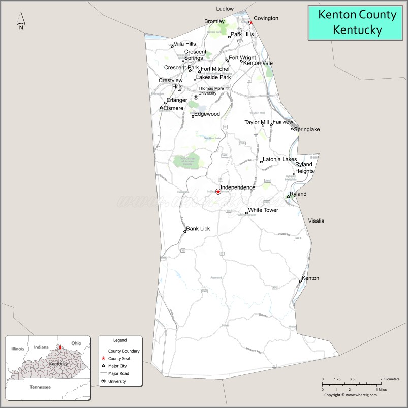
About Kenton County Map, Kentucky: The map showing the county boundary, county seat, major cities, highways, water bodies and neighbouring counties.
More Kentucky Maps & Info
Map of Kenton County, Kentucky
Kenton County is a county located in the U.S. state of Kentucky. It's county seat is Covington and Independence. As per 2020 census, the population of Kenton County is 169495 people and population density is square miles. According to the United States Census Bureau, the county has a total area of 163 sq mi (422 km2). Kenton County was established on 1840.
Kenton County Facts
| Continent | North America |
| Country | United States |
| State | Kentucky |
| County Seat | Covington |
| Largest City/Town | Covington |
| Established | 1840 |
| Total Area | 164 sq mi (425 sq km) |
| Land Area | 160 sq mi (414 sq km) |
| Water Area | 4.1 sq mi (11 sq km) |
| Population | 169,064 (Census 2020) |
| Population Density | 1,056 people per sq mi |
| Time Zone | Eastern Time Zone (ET) |
| Major Highways | Interstate 71, Interstate 75, Interstate 275, Interstate 471 nearby area, U.S. Route 25 |
| Major Rivers | Ohio River, Licking River |
| Neighboring Counties | Boone County, Campbell County, Grant County, Hamilton County (OH) |
| Famous For | Cincinnati metropolitan area, riverfront entertainment, historic architecture, and Northern Kentucky culture |
| Top Attractions | MainStrasse Village, Devou Park, Cathedral Basilica of the Assumption, Newport Aquarium nearby area, Covington riverfront |
| Official Website | Official Website |
About Kenton County, Kentucky
Kenton County is located in northern Kentucky along the Ohio River and was established in 1840. The county seat and largest city is Covington. Kenton County is known for its historic neighborhoods, vibrant riverfront districts, Cincinnati metropolitan connections, and cultural attractions throughout Northern Kentucky. ([en.wikipedia.org](https://en.wikipedia.org/wiki/Kenton_County%2C_Kentucky?utm_source=chatgpt.com))
Ctities in Kenton county
| City Name | Type | Population (2020) | Pop. Density | Area | Incorporated |
|---|---|---|---|---|---|
| Walton | 5,460 | 4.3 sq mi (11.1 km2) | 1854 | ||
| Bromley | 724 | 0.4 sq mi (1.0 km2) | 1890 | ||
| Covington | 40,961 | 13.8 sq mi (35.7 km2) | 1834 | ||
| Crescent Springs | 4,319 | 1.5 sq mi (3.9 km2) | 1957 | ||
| Crestview Hills | 3,246 | 1.9 sq mi (4.9 km2) | 1951 | ||
| Edgewood | 8,435 | 4.2 sq mi (10.9 km2) | 1948 | ||
| Elsmere | 9,159 | 2.6 sq mi (6.7 km2) | 1896 | ||
| Erlanger | 19,611 | 8.5 sq mi (22.0 km2) | 1897 | ||
| Fairview | 144 | 0.7 sq mi (1.8 km2) | 1957 | ||
| Fort Mitchell | 8,702 | 3.2 sq mi (8.3 km2) | 1910 | ||
| Fort Wright | 5,851 | 3.4 sq mi (8.8 km2) | 1941 | ||
| Independence | 28,676 | 17.7 sq mi (45.8 km2) | 1842 | ||
| Kenton Vale | 105 | 0.1 sq mi (0.3 km2) | 1949 | ||
| Lakeside Park | 2,841 | 0.8 sq mi (2.1 km2) | 1930 | ||
| Ludlow | 4,385 | 1.2 sq mi (3.1 km2) | 1864 | ||
| Park Hills | 3,162 | 0.8 sq mi (2.1 km2) | 1927 | ||
| Ryland Heights | 922 | 5.3 sq mi (13.7 km2) | 1972 | ||
| Taylor Mill | 6,873 | 6.3 sq mi (16.3 km2) | 1956 | ||
| Villa Hills | 7,310 | 4.4 sq mi (11.4 km2) | 1962 |
Best Golf Courses in Kenton County, Kentucky
| Golf Course | Location | Latitude & Longitude |
|---|---|---|
| Twin Oaks Golf & Magnolia Room | Covington Area | 38.9950°N, 84.5348°W |
| Devou Park Golf Course | Covington | 39.0715°N, 84.5341°W |
| Summit Hills Country Club | Crestview Hills | 39.0318°N, 84.5734°W |
| Hickory Sticks Golf Club | Nearby Burlington | 39.0314°N, 84.7312°W |
What are Major Roads and Highways in Kenton County
Major interstate highways connect Kenton County with Cincinnati, Louisville, Lexington, and regional Midwest destinations.
- Interstate 71 - major interstate linking Northern Kentucky with Louisville and Cincinnati
- Interstate 75 - important north-south corridor through the Cincinnati metropolitan area
- Interstate 275 - beltway surrounding Greater Cincinnati communities
- Interstate 471 nearby area - connector route linking Northern Kentucky with downtown Cincinnati
- U.S. Route 25 - historic roadway serving Kenton County communities
Neighboring Counties of Kenton County
- Boone County (west)
- Campbell County (east)
- Grant County (south)
- Hamilton County, Ohio (north across the Ohio River)
What are Top Attractions in Kenton County, Kentucky
The county offers riverfront entertainment, parks, historic districts, museums, and urban recreation attractions.
| Main Sight Name | City | Famous For |
|---|---|---|
| MainStrasse Village | Covington | Historic district, dining, and nightlife |
| Devou Park | Covington | Scenic overlooks, golf course, and hiking trails |
| Cathedral Basilica of the Assumption | Covington | Historic Gothic architecture and stained glass |
| Newport Aquarium Nearby Area | Newport Area | Marine exhibits and family attractions |
| Covington Riverfront | Covington | Ohio River views and entertainment districts |
| Behringer-Crawford Museum | Covington | Regional history and cultural exhibits |
| Goebel Park | Covington | Community recreation and local events |
| Historic Roebling Suspension Bridge Nearby Area | Covington Area | Historic bridge connecting Kentucky and Ohio |
| Independence Historic Area | Independence | Local heritage and small-town charm |
| Northern Kentucky Riverfront Districts | Countywide | Dining, shopping, and entertainment attractions |
Distance from Kenton County to Nearby Cities
The following distances are measured by road (driving).
- Covington to Cincinnati, Ohio - 3 mi (5 km)
- Covington to Lexington, Kentucky - 84 mi (135 km)
- Covington to Louisville, Kentucky - 99 mi (159 km)
- Covington to Columbus, Ohio - 108 mi (174 km)
- Covington to Indianapolis, Indiana - 114 mi (183 km)
- Covington to Dayton, Ohio - 57 mi (92 km)
- Covington to Nashville, Tennessee - 275 mi (443 km)
- Covington to Chicago, Illinois - 299 mi (481 km)
- Covington to Knoxville, Tennessee - 262 mi (422 km)
- Covington to St. Louis, Missouri - 347 mi (558 km)
- Covington to Detroit, Michigan - 264 mi (425 km)
- Covington to Atlanta, Georgia - 462 mi (744 km)
References
- Kenton County Official Website
- Kenton County, Kentucky - Wikipedia
- U.S. Census Bureau QuickFacts
- Northern Kentucky Tourism
- City of Covington
- Adair County Map
- Allen County Map
- Anderson County Map
- Ballard County Map
- Barren County Map
- Bath County Map
- Bell County Map
- Boone County Map
- Bourbon County Map
- Boyd County Map
- Boyle County Map
- Bracken County Map
- Breathitt County Map
- Breckinridge County Map
- Bullitt County Map
- Butler County Map
- Caldwell County Map
- Calloway County Map
- Campbell County Map
- Carlisle County Map
- Carroll County Map
- Carter County Map
- Casey County Map
- Christian County Map
- Clark County Map
- Clay County Map
- Clinton County Map
- Crittenden County Map
- Cumberland County Map
- Daviess County Map
- Edmonson County Map
- Elliott County Map
- Estill County Map
- Fayette County Map
- Fleming County Map
- Floyd County Map
- Franklin County Map
- Fulton County Map
- Gallatin County Map
- Garrard County Map
- Grant County Map
- Graves County Map
- Grayson County Map
- Green County Map
- Greenup County Map
- Hancock County Map
- Hardin County Map
- Harlan County Map
- Harrison County Map
- Hart County Map
- Henderson County Map
- Henry County Map
- Hickman County Map
- Hopkins County Map
- Jackson County Map
- Jefferson County Map
- Jessamine County Map
- Johnson County Map
- Kenton County Map
- Knott County Map
- Knox County Map
- LaRue County Map
- Laurel County Map
- Lawrence County Map
- Lee County Map
- Leslie County Map
- Letcher County Map
- Lewis County Map
- Lincoln County Map
- Livingston County Map
- Logan County Map
- Lyon County Map
- McCracken County Map
- McCreary County Map
- McLean County Map
- Madison County Map
- Magoffin County Map
- Marion County Map
- Marshall County Map
- Martin County Map
- Mason County Map
- Meade County Map
- Menifee County Map
- Mercer County Map
- Metcalfe County Map
- Monroe County Map
- Montgomery County Map
- Morgan County Map
- Muhlenberg County Map
- Nelson County Map
- Nicholas County Map
- Ohio County Map
- Oldham County Map
- Owen County Map
- Owsley County Map
- Pendleton County Map
- Perry County Map
- Pike County Map
- Powell County Map
- Pulaski County Map
- Robertson County Map
- Rockcastle County Map
- Rowan County Map
- Russell County Map
- Scott County Map
- Shelby County Map
- Simpson County Map
- Spencer County Map
- Taylor County Map
- Todd County Map
- Trigg County Map
- Trimble County Map
- Union County Map
- Warren County Map
- Washington County Map
- Wayne County Map
- Webster County Map
- Whitley County Map
- Wolfe County Map
- Woodford County Map
- Alabama Counties
- Alaska boroughs
- Arizona Counties
- Arkansas Counties
- California County Map
- Colorado Counties
- Connecticut Counties
- Delaware Counties
- Florida County Map
- Georgia County Map
- Hawaii Counties
- Idaho Counties
- Illinois Counties
- Indiana Counties
- Iowa Counties
- Kansas Counties
- Kentucky Counties
- Louisiana Counties
- Maine Counties
- Maryland Counties
- Massachusetts Counties
- Michigan County Map
- Minnesota Counties
- Mississippi Counties
- Missouri Counties
- Montana Counties
- Nebraska Counties
- Nevada Counties
- New York Counties
- New Hampshire Counties
- New Jersey Counties
- New Mexico Counties
- North Carolina Counties
- North Dakota Counties
- Ohio County Map
- Oklahoma Counties
- Oregon Counties
- Pennsylvania Counties
- Rhode Island Counties
- South Carolina Counties
- South Dakota Counties
- Map of Tennessee
- Texas County Map
- Utah Counties
- Vermont Counties
- Virginia Counties
- Washington Counties
- West Virginia Counties
- Wisconsin Counties
- Wyoming Counties