Map of Grant County - Grant County is a county located in the U.S. state of Kentucky. Grant County Map showing cities, highways, important places and water bodies. Get Where is Grant County located in the map, major cities in Grant county, population, areas, and places of interest.
Map of Grant County, Kentucky
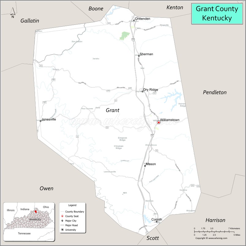
About Grant County Map, Kentucky: The map showing the county boundary, county seat, major cities, highways, water bodies and neighbouring counties.
More Kentucky Maps & Info
Map of Grant County, Kentucky
Grant County is a county located in the U.S. state of Kentucky. It's county seat is Williamstown. As per 2020 census, the population of Grant County is 25244 people and population density is square miles. According to the United States Census Bureau, the county has a total area of 260 sq mi (673 km2). Grant County was established on 1820.
Grant County Facts
| Continent | North America |
| Country | United States |
| State | Kentucky |
| County Seat | Williamstown |
| Largest City/Town | Williamstown |
| Established | 1820 |
| Total Area | 261 sq mi (676 sq km) |
| Land Area | 259 sq mi (671 sq km) |
| Water Area | 1.9 sq mi (5 sq km) |
| Population | 24,941 (Census 2020) |
| Population Density | 96 people per sq mi |
| Time Zone | Eastern Time Zone (ET) |
| Major Highways | Interstate 75, U.S. Route 25, Kentucky Route 22, Kentucky Route 36 |
| Major Rivers | Eagle Creek, Licking River nearby area |
| Neighboring Counties | Boone County, Kenton County, Pendleton County, Harrison County, Scott County, Owen County, Gallatin County |
| Famous For | Ark Encounter, rolling Bluegrass hills, lakes, and northern Kentucky tourism |
| Top Attractions | Ark Encounter, Williamstown Lake, Sherman Tavern, Grant County Park, Eagle Creek Country Club |
| Official Website | Official Website |
About Grant County, Kentucky
Grant County is located in northern Kentucky within the Bluegrass region and was established in 1820 from Pendleton County. The county seat and largest city is Williamstown. Grant County is known for the Ark Encounter attraction, scenic rolling hills, outdoor recreation areas, and its convenient location between Lexington and Cincinnati. :contentReference[oaicite:0]{index=0}
Cities and Communities in Grant County, Kentucky
| City/Town | Population | Latitude & Longitude |
|---|---|---|
| Williamstown (county seat) | 3,800+ | 38.6381°N, 84.5605°W |
| Dry Ridge | 2,400+ | 38.6828°N, 84.5897°W |
| Crittenden | 4,000+ | 38.7820°N, 84.6055°W |
| Corinth | 250+ | 38.4926°N, 84.6316°W |
| Mason | Historic Community | 38.5939°N, 84.5824°W |
| Sherman | Historic Community | 38.6874°N, 84.6030°W |
| Jonesville | Unincorporated | 38.6428°N, 84.6411°W |
| Elliston | Rural Community | 38.7421°N, 84.7052°W |
Best Golf Courses in Grant County, Kentucky
| Golf Course | Location | Latitude & Longitude |
|---|---|---|
| Eagle Creek Country Club | Crittenden | 38.7748°N, 84.6297°W |
| Brianza Gardens & Golf | Dry Ridge Area | 38.6941°N, 84.6059°W |
| Cherry Blossom Golf Club | Nearby Georgetown | 38.2129°N, 84.5547°W |
| Boone Links Golf Course | Nearby Florence | 38.9840°N, 84.6548°W |
What are Major Roads and Highways in Grant County
Major highways connect Grant County with Cincinnati, Lexington, and northern Kentucky communities.
- Interstate 75 - major interstate connecting Cincinnati and Lexington through Grant County
- U.S. Route 25 - historic north-south highway passing through Williamstown and Dry Ridge
- Kentucky Route 22 - regional connector serving rural communities and countryside areas
- Kentucky Route 36 - east-west route connecting Grant County with neighboring counties
Neighboring Counties of Grant County
- Boone County (north)
- Kenton County (northeast)
- Pendleton County (east)
- Harrison County (southeast)
- Scott County (south)
- Owen County (west)
- Gallatin County (northwest)
What are Top Attractions in Grant County, Kentucky
The county offers family attractions, lakes, parks, historic sites, and scenic northern Kentucky landscapes.
| Main Sight Name | City | Famous For |
|---|---|---|
| Ark Encounter | Williamstown | Life-sized Noah’s Ark attraction and family tourism destination |
| Williamstown Lake | Williamstown | Boating, fishing, and water recreation |
| Sherman Tavern | Sherman | Historic stagecoach stop and Kentucky heritage |
| Grant County Park | Williamstown Area | Sports facilities, trails, and outdoor recreation |
| Eagle Creek Country Club | Crittenden | Golf and countryside scenery |
| Dry Ridge Historic Area | Dry Ridge | Local shops and small-town atmosphere |
| Boltz Lake Nearby Area | Dry Ridge Area | Fishing and lakeside recreation |
| Lloyd Wildlife Area Nearby Area | Crittenden Area | Wildlife viewing and nature photography |
| Scenic Bluegrass Drives | Countywide | Rolling hills and farmland scenery |
| Historic Downtown Williamstown | Williamstown | Restaurants, shops, and local history |
Distance from Grant County to Nearby Cities
The following distances are measured by road (driving).
- Williamstown to Cincinnati, Ohio - 37 mi (60 km)
- Williamstown to Lexington, Kentucky - 45 mi (72 km)
- Williamstown to Frankfort, Kentucky - 58 mi (93 km)
- Williamstown to Louisville, Kentucky - 88 mi (142 km)
- Williamstown to Florence, Kentucky - 25 mi (40 km)
- Williamstown to Covington, Kentucky - 34 mi (55 km)
- Williamstown to Columbus, Ohio - 132 mi (212 km)
- Williamstown to Indianapolis, Indiana - 122 mi (196 km)
- Williamstown to Nashville, Tennessee - 255 mi (410 km)
- Williamstown to Knoxville, Tennessee - 217 mi (349 km)
- Williamstown to Chicago, Illinois - 305 mi (491 km)
- Williamstown to St. Louis, Missouri - 333 mi (536 km)
References
- Grant County Official Website
- Grant County, Kentucky - Wikipedia
- Visit Grant County Tourism
- U.S. Census Bureau QuickFacts
- Grant County Chamber of Commerce
- Adair County Map
- Allen County Map
- Anderson County Map
- Ballard County Map
- Barren County Map
- Bath County Map
- Bell County Map
- Boone County Map
- Bourbon County Map
- Boyd County Map
- Boyle County Map
- Bracken County Map
- Breathitt County Map
- Breckinridge County Map
- Bullitt County Map
- Butler County Map
- Caldwell County Map
- Calloway County Map
- Campbell County Map
- Carlisle County Map
- Carroll County Map
- Carter County Map
- Casey County Map
- Christian County Map
- Clark County Map
- Clay County Map
- Clinton County Map
- Crittenden County Map
- Cumberland County Map
- Daviess County Map
- Edmonson County Map
- Elliott County Map
- Estill County Map
- Fayette County Map
- Fleming County Map
- Floyd County Map
- Franklin County Map
- Fulton County Map
- Gallatin County Map
- Garrard County Map
- Grant County Map
- Graves County Map
- Grayson County Map
- Green County Map
- Greenup County Map
- Hancock County Map
- Hardin County Map
- Harlan County Map
- Harrison County Map
- Hart County Map
- Henderson County Map
- Henry County Map
- Hickman County Map
- Hopkins County Map
- Jackson County Map
- Jefferson County Map
- Jessamine County Map
- Johnson County Map
- Kenton County Map
- Knott County Map
- Knox County Map
- LaRue County Map
- Laurel County Map
- Lawrence County Map
- Lee County Map
- Leslie County Map
- Letcher County Map
- Lewis County Map
- Lincoln County Map
- Livingston County Map
- Logan County Map
- Lyon County Map
- McCracken County Map
- McCreary County Map
- McLean County Map
- Madison County Map
- Magoffin County Map
- Marion County Map
- Marshall County Map
- Martin County Map
- Mason County Map
- Meade County Map
- Menifee County Map
- Mercer County Map
- Metcalfe County Map
- Monroe County Map
- Montgomery County Map
- Morgan County Map
- Muhlenberg County Map
- Nelson County Map
- Nicholas County Map
- Ohio County Map
- Oldham County Map
- Owen County Map
- Owsley County Map
- Pendleton County Map
- Perry County Map
- Pike County Map
- Powell County Map
- Pulaski County Map
- Robertson County Map
- Rockcastle County Map
- Rowan County Map
- Russell County Map
- Scott County Map
- Shelby County Map
- Simpson County Map
- Spencer County Map
- Taylor County Map
- Todd County Map
- Trigg County Map
- Trimble County Map
- Union County Map
- Warren County Map
- Washington County Map
- Wayne County Map
- Webster County Map
- Whitley County Map
- Wolfe County Map
- Woodford County Map
- Alabama Counties
- Alaska boroughs
- Arizona Counties
- Arkansas Counties
- California County Map
- Colorado Counties
- Connecticut Counties
- Delaware Counties
- Florida County Map
- Georgia County Map
- Hawaii Counties
- Idaho Counties
- Illinois Counties
- Indiana Counties
- Iowa Counties
- Kansas Counties
- Kentucky Counties
- Louisiana Counties
- Maine Counties
- Maryland Counties
- Massachusetts Counties
- Michigan County Map
- Minnesota Counties
- Mississippi Counties
- Missouri Counties
- Montana Counties
- Nebraska Counties
- Nevada Counties
- New York Counties
- New Hampshire Counties
- New Jersey Counties
- New Mexico Counties
- North Carolina Counties
- North Dakota Counties
- Ohio County Map
- Oklahoma Counties
- Oregon Counties
- Pennsylvania Counties
- Rhode Island Counties
- South Carolina Counties
- South Dakota Counties
- Map of Tennessee
- Texas County Map
- Utah Counties
- Vermont Counties
- Virginia Counties
- Washington Counties
- West Virginia Counties
- Wisconsin Counties
- Wyoming Counties