Map of Hopkins County - Hopkins County is a county located in the U.S. state of Kentucky. Hopkins County Map showing cities, highways, important places and water bodies. Get Where is Hopkins County located in the map, major cities in Hopkins county, population, areas, and places of interest.
Map of Hopkins County, Kentucky
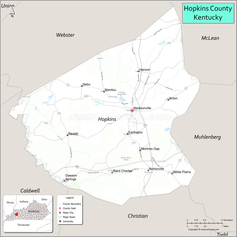
About Hopkins County Map, Kentucky: The map showing the county boundary, county seat, major cities, highways, water bodies and neighbouring counties.
More Kentucky Maps & Info
Map of Hopkins County, Kentucky
Hopkins County is a county located in the U.S. state of Kentucky. It's county seat is Madisonville. As per 2020 census, the population of Hopkins County is 45138 people and population density is square miles. According to the United States Census Bureau, the county has a total area of 551 sq mi (1,427 km2). Hopkins County was established on 1806.
Hopkins County Facts
| Continent | North America |
| Country | United States |
| State | Kentucky |
| County Seat | Madisonville |
| Largest City/Town | Madisonville |
| Established | 1806 |
| Total Area | 554 sq mi (1,435 sq km) |
| Land Area | 542 sq mi (1,404 sq km) |
| Water Area | 12 sq mi (31 sq km) |
| Population | 45,423 (Census 2020) |
| Population Density | 84 people per sq mi |
| Time Zone | Central Time Zone (CT) |
| Major Highways | Interstate 69, Western Kentucky Parkway, U.S. Route 41, Pennyrile Parkway nearby area |
| Major Rivers | Tradewater River, Green River, Pond River |
| Neighboring Counties | Caldwell County, Christian County, Webster County, Muhlenberg County, McLean County |
| Famous For | Western Kentucky coal fields, Madisonville history, agriculture, and outdoor recreation |
| Top Attractions | Pennyrile Forest State Resort Park nearby area, Madisonville City Park, Glema Mahr Center for the Arts, Rail Trail, Historic Downtown Madisonville |
| Official Website | Official Website |
About Hopkins County, Kentucky
Hopkins County is located in western Kentucky within the Western Coal Fields region and was established in 1806 from Henderson County. The county seat and largest city is Madisonville. Hopkins County is known for coal mining heritage, rolling farmland, outdoor recreation, and its role as an important commercial and transportation center in western Kentucky. :contentReference[oaicite:0]{index=0}
Cities and Communities in Hopkins County, Kentucky
| City/Town | Population | Latitude & Longitude |
|---|---|---|
| Madisonville (county seat) | 19,500+ | 37.3281°N, 87.4989°W |
| Dawson Springs | 2,200+ | 37.1684°N, 87.6928°W |
| Earlington | 1,200+ | 37.2740°N, 87.5114°W |
| Nortonville | 900+ | 37.1887°N, 87.4525°W |
| Mortons Gap | 700+ | 37.2373°N, 87.4761°W |
| Hanson | 700+ | 37.4175°N, 87.4839°W |
| White Plains | 800+ | 37.1862°N, 87.3850°W |
| St. Charles | 300+ | 37.1892°N, 87.5556°W |
Best Golf Courses in Hopkins County, Kentucky
| Golf Course | Location | Latitude & Longitude |
|---|---|---|
| Madisonville Country Club | Madisonville | 37.3511°N, 87.5128°W |
| Ridgewood Terrace Country Club | Madisonville Area | 37.3359°N, 87.4888°W |
| Pennyrile Forest Golf Course | Nearby Dawson Springs | 37.0964°N, 87.6887°W |
| Lake Tanglewood Golf Course | Nearby Dawson Springs | 37.1465°N, 87.6772°W |
What are Major Roads and Highways in Hopkins County
Major highways connect Hopkins County with Evansville, Nashville, Paducah, and western Kentucky communities.
- Interstate 69 - major interstate corridor through Madisonville and western Kentucky
- Western Kentucky Parkway - important east-west transportation route
- U.S. Route 41 - regional highway connecting local communities and industrial areas
- Pennyrile Parkway nearby area - major corridor serving western Kentucky travel
Neighboring Counties of Hopkins County
- Caldwell County (west)
- Christian County (southwest)
- Webster County (northwest)
- Muhlenberg County (east)
- McLean County (north)
What are Top Attractions in Hopkins County, Kentucky
The county features parks, museums, outdoor recreation, arts venues, and scenic western Kentucky landscapes.
| Main Sight Name | City | Famous For |
|---|---|---|
| Pennyrile Forest State Resort Park Nearby Area | Dawson Springs Area | Camping, hiking, fishing, and forest scenery |
| Madisonville City Park | Madisonville | Sports facilities and family recreation |
| Glema Mahr Center for the Arts | Madisonville | Performing arts and cultural events |
| Rail Trail | Madisonville | Walking and cycling recreation |
| Historic Downtown Madisonville | Madisonville | Historic architecture and local businesses |
| Mahr Park Arboretum | Madisonville | Gardens, trails, and wildlife observation |
| Dawson Springs Historic Area | Dawson Springs | Historic mineral springs heritage |
| Tradewater River Scenic Areas | Countywide | Fishing and natural landscapes |
| Coal Mining Heritage Sites | Countywide | Regional industrial history |
| Community Festivals and Events | Countywide | Local culture and seasonal celebrations |
Distance from Hopkins County to Nearby Cities
The following distances are measured by road (driving).
- Madisonville to Evansville, Indiana - 58 mi (93 km)
- Madisonville to Owensboro, Kentucky - 48 mi (77 km)
- Madisonville to Paducah, Kentucky - 74 mi (119 km)
- Madisonville to Bowling Green, Kentucky - 88 mi (142 km)
- Madisonville to Nashville, Tennessee - 122 mi (196 km)
- Madisonville to Louisville, Kentucky - 143 mi (230 km)
- Madisonville to Memphis, Tennessee - 210 mi (338 km)
- Madisonville to St. Louis, Missouri - 177 mi (285 km)
- Madisonville to Lexington, Kentucky - 212 mi (341 km)
- Madisonville to Indianapolis, Indiana - 215 mi (346 km)
- Madisonville to Cincinnati, Ohio - 248 mi (399 km)
- Madisonville to Chicago, Illinois - 331 mi (533 km)
References
- Hopkins County Official Website
- Hopkins County, Kentucky - Wikipedia
- U.S. Census Bureau QuickFacts
- Pennyrile Forest State Resort Park
- Visit Madisonville Kentucky
- Adair County Map
- Allen County Map
- Anderson County Map
- Ballard County Map
- Barren County Map
- Bath County Map
- Bell County Map
- Boone County Map
- Bourbon County Map
- Boyd County Map
- Boyle County Map
- Bracken County Map
- Breathitt County Map
- Breckinridge County Map
- Bullitt County Map
- Butler County Map
- Caldwell County Map
- Calloway County Map
- Campbell County Map
- Carlisle County Map
- Carroll County Map
- Carter County Map
- Casey County Map
- Christian County Map
- Clark County Map
- Clay County Map
- Clinton County Map
- Crittenden County Map
- Cumberland County Map
- Daviess County Map
- Edmonson County Map
- Elliott County Map
- Estill County Map
- Fayette County Map
- Fleming County Map
- Floyd County Map
- Franklin County Map
- Fulton County Map
- Gallatin County Map
- Garrard County Map
- Grant County Map
- Graves County Map
- Grayson County Map
- Green County Map
- Greenup County Map
- Hancock County Map
- Hardin County Map
- Harlan County Map
- Harrison County Map
- Hart County Map
- Henderson County Map
- Henry County Map
- Hickman County Map
- Hopkins County Map
- Jackson County Map
- Jefferson County Map
- Jessamine County Map
- Johnson County Map
- Kenton County Map
- Knott County Map
- Knox County Map
- LaRue County Map
- Laurel County Map
- Lawrence County Map
- Lee County Map
- Leslie County Map
- Letcher County Map
- Lewis County Map
- Lincoln County Map
- Livingston County Map
- Logan County Map
- Lyon County Map
- McCracken County Map
- McCreary County Map
- McLean County Map
- Madison County Map
- Magoffin County Map
- Marion County Map
- Marshall County Map
- Martin County Map
- Mason County Map
- Meade County Map
- Menifee County Map
- Mercer County Map
- Metcalfe County Map
- Monroe County Map
- Montgomery County Map
- Morgan County Map
- Muhlenberg County Map
- Nelson County Map
- Nicholas County Map
- Ohio County Map
- Oldham County Map
- Owen County Map
- Owsley County Map
- Pendleton County Map
- Perry County Map
- Pike County Map
- Powell County Map
- Pulaski County Map
- Robertson County Map
- Rockcastle County Map
- Rowan County Map
- Russell County Map
- Scott County Map
- Shelby County Map
- Simpson County Map
- Spencer County Map
- Taylor County Map
- Todd County Map
- Trigg County Map
- Trimble County Map
- Union County Map
- Warren County Map
- Washington County Map
- Wayne County Map
- Webster County Map
- Whitley County Map
- Wolfe County Map
- Woodford County Map
- Alabama Counties
- Alaska boroughs
- Arizona Counties
- Arkansas Counties
- California County Map
- Colorado Counties
- Connecticut Counties
- Delaware Counties
- Florida County Map
- Georgia County Map
- Hawaii Counties
- Idaho Counties
- Illinois Counties
- Indiana Counties
- Iowa Counties
- Kansas Counties
- Kentucky Counties
- Louisiana Counties
- Maine Counties
- Maryland Counties
- Massachusetts Counties
- Michigan County Map
- Minnesota Counties
- Mississippi Counties
- Missouri Counties
- Montana Counties
- Nebraska Counties
- Nevada Counties
- New York Counties
- New Hampshire Counties
- New Jersey Counties
- New Mexico Counties
- North Carolina Counties
- North Dakota Counties
- Ohio County Map
- Oklahoma Counties
- Oregon Counties
- Pennsylvania Counties
- Rhode Island Counties
- South Carolina Counties
- South Dakota Counties
- Map of Tennessee
- Texas County Map
- Utah Counties
- Vermont Counties
- Virginia Counties
- Washington Counties
- West Virginia Counties
- Wisconsin Counties
- Wyoming Counties