Map of Edmonson County - Edmonson County is a county located in the U.S. state of Kentucky. Edmonson County Map showing cities, highways, important places and water bodies. Get Where is Edmonson County located in the map, major cities in Edmonson county, population, areas, and places of interest.
Map of Edmonson County, Kentucky
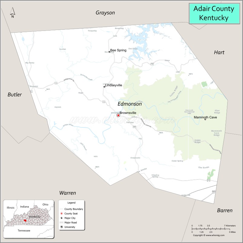
About Edmonson County Map, Kentucky: The map showing the county boundary, county seat, major cities, highways, water bodies and neighbouring counties.
More Kentucky Maps & Info
Map of Edmonson County, Kentucky
Edmonson County is a county located in the U.S. state of Kentucky. It's county seat is Brownsville. As per 2020 census, the population of Edmonson County is 12291 people and population density is square miles. According to the United States Census Bureau, the county has a total area of 303 sq mi (785 km2). Edmonson County was established on 1825.
Edmonson County Facts
| Continent | North America |
| Country | United States |
| State | Kentucky |
| County Seat | Brownsville |
| Largest City/Town | Brownsville |
| Established | 1825 |
| Total Area | 308 sq mi (798 sq km) |
| Land Area | 303 sq mi (785 sq km) |
| Water Area | 4.6 sq mi (12 sq km) |
| Population | 12,126 (Census 2020) |
| Population Density | 40 people per sq mi |
| Time Zone | Central Time Zone (CT) |
| Major Highways | Kentucky Route 70, Kentucky Route 259, Kentucky Route 101, Interstate 65 nearby area |
| Major Rivers | Green River, Nolin River |
| Neighboring Counties | Warren County, Hart County, Butler County, Grayson County, Barren County |
| Famous For | Mammoth Cave National Park, Green River recreation, cave systems, and scenic Kentucky landscapes |
| Top Attractions | Mammoth Cave National Park, Green River Ferry, Nolin Lake nearby area, Cedar Sink Trail, Brownsville Historic District |
| Official Website | Official Website |
About Edmonson County, Kentucky
Edmonson County is located in south-central Kentucky and was established in 1825. The county seat and largest city is Brownsville. Edmonson County is best known as the home of much of Mammoth Cave National Park, the world’s longest known cave system, along with scenic rivers, forests, and outdoor recreation opportunities. ([en.wikipedia.org](https://en.wikipedia.org/wiki/Edmonson_County%2C_Kentucky?utm_source=chatgpt.com))
Cities and Communities in Edmonson County, Kentucky
| City/Town | Population | Latitude & Longitude |
|---|---|---|
| Brownsville (county seat) | 850+ | 37.1925°N, 86.2675°W |
| Park City Nearby Area | Regional Community | 37.0920°N, 86.0516°W |
| Sweeden | Unincorporated | 37.2492°N, 86.2609°W |
| Wingfield | Unincorporated | 37.2065°N, 86.1737°W |
| Lindseyville | Unincorporated | 37.2654°N, 86.1079°W |
| Kyrock | Historic Community | 37.2735°N, 86.2261°W |
| Sunfish | Unincorporated | 37.2870°N, 86.3045°W |
| Roundhill Nearby Area | Regional Community | 37.2579°N, 86.4144°W |
Best Golf Courses in Edmonson County, Kentucky
| Golf Course | Location | Latitude & Longitude |
|---|---|---|
| Shady Hollow Golf Course | Cub Run Area | 37.2847°N, 86.0898°W |
| Crosswinds Golf Course | Nearby Bowling Green | 36.9954°N, 86.4385°W |
| Riverview at Hobson Grove | Nearby Bowling Green | 36.9777°N, 86.4434°W |
| Cedar Point Golf Course | Nearby Cave City | 37.1286°N, 85.9208°W |
What are Major Roads and Highways in Edmonson County
Major highways connect Edmonson County with Mammoth Cave National Park, Bowling Green, and nearby Kentucky lake regions.
- Kentucky Route 70 - major east-west highway through Brownsville and Mammoth Cave region
- Kentucky Route 259 - important north-south connector serving cave and recreation areas
- Kentucky Route 101 - scenic roadway through rural communities and forests
- Interstate 65 nearby area - major interstate connecting Louisville and Nashville
Neighboring Counties of Edmonson County
- Warren County (southwest)
- Hart County (east)
- Butler County (west)
- Grayson County (north)
- Barren County (southeast)
What are Top Attractions in Edmonson County, Kentucky
The county offers cave exploration, river recreation, forests, and scenic outdoor destinations.
| Main Sight Name | City | Famous For |
|---|---|---|
| Mammoth Cave National Park | Park City Area | World's longest known cave system and hiking trails |
| Green River Ferry | Mammoth Cave Area | Historic river crossing within the national park |
| Nolin Lake Nearby Area | Northern County Area | Boating, fishing, and camping recreation |
| Cedar Sink Trail | Mammoth Cave Area | Karst sinkhole landscapes and hiking |
| Brownsville Historic District | Brownsville | Historic buildings and local shops |
| Green River | Countywide | Canoeing, kayaking, and fishing |
| Mammoth Cave Visitor Center | Mammoth Cave Area | Cave tours and educational exhibits |
| Kyrock Historic Area | Kyrock | Historic company town and cave region heritage |
| Lincoln Hometown Memorial | Brownsville Area | Historical regional landmark |
| Scenic Forest Drives | Countywide | Rolling hills and woodland landscapes |
Distance from Edmonson County to Nearby Cities
The following distances are measured by road (driving).
- Brownsville to Bowling Green, Kentucky - 26 mi (42 km)
- Brownsville to Elizabethtown, Kentucky - 63 mi (101 km)
- Brownsville to Louisville, Kentucky - 98 mi (158 km)
- Brownsville to Nashville, Tennessee - 92 mi (148 km)
- Brownsville to Glasgow, Kentucky - 39 mi (63 km)
- Brownsville to Owensboro, Kentucky - 73 mi (117 km)
- Brownsville to Lexington, Kentucky - 142 mi (229 km)
- Brownsville to Evansville, Indiana - 108 mi (174 km)
- Brownsville to Paducah, Kentucky - 118 mi (190 km)
- Brownsville to Cincinnati, Ohio - 193 mi (311 km)
- Brownsville to Indianapolis, Indiana - 182 mi (293 km)
- Brownsville to Memphis, Tennessee - 234 mi (377 km)
References
- Edmonson County Official Website
- Edmonson County, Kentucky - Wikipedia
- U.S. Census Bureau QuickFacts
- Mammoth Cave National Park
- Kentucky Atlas and Gazetteer
- Adair County Map
- Allen County Map
- Anderson County Map
- Ballard County Map
- Barren County Map
- Bath County Map
- Bell County Map
- Boone County Map
- Bourbon County Map
- Boyd County Map
- Boyle County Map
- Bracken County Map
- Breathitt County Map
- Breckinridge County Map
- Bullitt County Map
- Butler County Map
- Caldwell County Map
- Calloway County Map
- Campbell County Map
- Carlisle County Map
- Carroll County Map
- Carter County Map
- Casey County Map
- Christian County Map
- Clark County Map
- Clay County Map
- Clinton County Map
- Crittenden County Map
- Cumberland County Map
- Daviess County Map
- Edmonson County Map
- Elliott County Map
- Estill County Map
- Fayette County Map
- Fleming County Map
- Floyd County Map
- Franklin County Map
- Fulton County Map
- Gallatin County Map
- Garrard County Map
- Grant County Map
- Graves County Map
- Grayson County Map
- Green County Map
- Greenup County Map
- Hancock County Map
- Hardin County Map
- Harlan County Map
- Harrison County Map
- Hart County Map
- Henderson County Map
- Henry County Map
- Hickman County Map
- Hopkins County Map
- Jackson County Map
- Jefferson County Map
- Jessamine County Map
- Johnson County Map
- Kenton County Map
- Knott County Map
- Knox County Map
- LaRue County Map
- Laurel County Map
- Lawrence County Map
- Lee County Map
- Leslie County Map
- Letcher County Map
- Lewis County Map
- Lincoln County Map
- Livingston County Map
- Logan County Map
- Lyon County Map
- McCracken County Map
- McCreary County Map
- McLean County Map
- Madison County Map
- Magoffin County Map
- Marion County Map
- Marshall County Map
- Martin County Map
- Mason County Map
- Meade County Map
- Menifee County Map
- Mercer County Map
- Metcalfe County Map
- Monroe County Map
- Montgomery County Map
- Morgan County Map
- Muhlenberg County Map
- Nelson County Map
- Nicholas County Map
- Ohio County Map
- Oldham County Map
- Owen County Map
- Owsley County Map
- Pendleton County Map
- Perry County Map
- Pike County Map
- Powell County Map
- Pulaski County Map
- Robertson County Map
- Rockcastle County Map
- Rowan County Map
- Russell County Map
- Scott County Map
- Shelby County Map
- Simpson County Map
- Spencer County Map
- Taylor County Map
- Todd County Map
- Trigg County Map
- Trimble County Map
- Union County Map
- Warren County Map
- Washington County Map
- Wayne County Map
- Webster County Map
- Whitley County Map
- Wolfe County Map
- Woodford County Map
- Alabama Counties
- Alaska boroughs
- Arizona Counties
- Arkansas Counties
- California County Map
- Colorado Counties
- Connecticut Counties
- Delaware Counties
- Florida County Map
- Georgia County Map
- Hawaii Counties
- Idaho Counties
- Illinois Counties
- Indiana Counties
- Iowa Counties
- Kansas Counties
- Kentucky Counties
- Louisiana Counties
- Maine Counties
- Maryland Counties
- Massachusetts Counties
- Michigan County Map
- Minnesota Counties
- Mississippi Counties
- Missouri Counties
- Montana Counties
- Nebraska Counties
- Nevada Counties
- New York Counties
- New Hampshire Counties
- New Jersey Counties
- New Mexico Counties
- North Carolina Counties
- North Dakota Counties
- Ohio County Map
- Oklahoma Counties
- Oregon Counties
- Pennsylvania Counties
- Rhode Island Counties
- South Carolina Counties
- South Dakota Counties
- Map of Tennessee
- Texas County Map
- Utah Counties
- Vermont Counties
- Virginia Counties
- Washington Counties
- West Virginia Counties
- Wisconsin Counties
- Wyoming Counties