Map of Lawrence County - Lawrence County is a county located in the U.S. state of Kentucky. Lawrence County Map showing cities, highways, important places and water bodies. Get Where is Lawrence County located in the map, major cities in Lawrence county, population, areas, and places of interest.
Map of Lawrence County, Kentucky
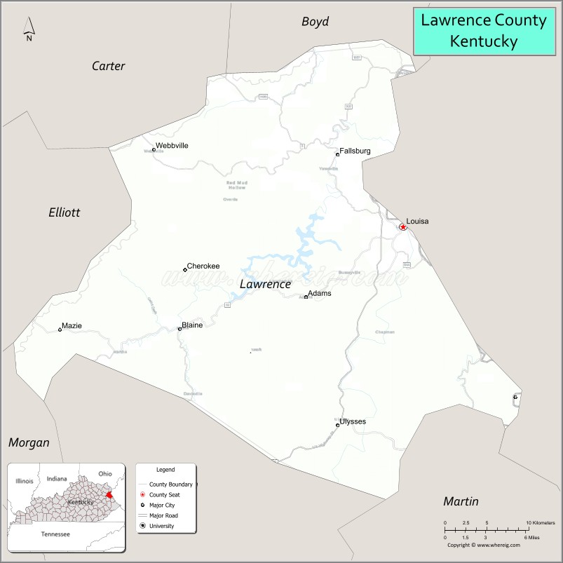
About Lawrence County Map, Kentucky: The map showing the county boundary, county seat, major cities, highways, water bodies and neighbouring counties.
More Kentucky Maps & Info
Map of Lawrence County, Kentucky
Lawrence County is a county located in the U.S. state of Kentucky. It's county seat is Louisa. As per 2020 census, the population of Lawrence County is 16290 people and population density is square miles. According to the United States Census Bureau, the county has a total area of 419 sq mi (1,085 km2). Lawrence County was established on 1821.
Lawrence County Facts
| Continent | North America |
| Country | United States |
| State | Kentucky |
| County Seat | Louisa |
| Largest City/Town | Louisa |
| Established | 1821 |
| Total Area | 420 sq mi (1,088 sq km) |
| Land Area | 416 sq mi (1,077 sq km) |
| Water Area | 4.5 sq mi (12 sq km) |
| Population | 16,293 (Census 2020) |
| Population Density | 39 people per sq mi |
| Time Zone | Eastern Time Zone (ET) |
| Major Highways | U.S. Route 23, Kentucky Route 3, Kentucky Route 32, Kentucky Route 644 |
| Major Rivers | Big Sandy River, Levisa Fork, Tug Fork |
| Neighboring Counties | Boyd County, Carter County, Elliott County, Johnson County, Martin County, Wayne County (WV) |
| Famous For | Yatesville Lake, Appalachian culture, country music heritage, and scenic eastern Kentucky hills |
| Top Attractions | Yatesville Lake State Park, Eagle Ridge Golf Course, Downtown Louisa, Lawrence County Museum, Big Sandy River recreation |
| Official Website | Official Website |
About Lawrence County, Kentucky
Lawrence County is located in eastern Kentucky within the Eastern Coal Field region and was established in 1821 from Floyd and Greenup counties. The county seat and largest city is Louisa. Lawrence County is known for Appalachian heritage, scenic river valleys, country music traditions, outdoor recreation at Yatesville Lake, and its location along the Big Sandy River bordering West Virginia. :contentReference[oaicite:0]{index=0}
Cities and Communities in Lawrence County, Kentucky
| City/Town | Population | Latitude & Longitude |
|---|---|---|
| Louisa (county seat) | 2,600+ | 38.1143°N, 82.6035°W |
| Blaine | 60+ | 38.0298°N, 82.7460°W |
| Fallsburg | Unincorporated | 38.1765°N, 82.7248°W |
| Lowmansville | Rural Community | 37.9990°N, 82.7426°W |
| Webbville | Historic Community | 38.0343°N, 82.8201°W |
| Ulysses | Unincorporated | 38.1508°N, 82.6464°W |
| Buchanan | Rural Community | 38.0667°N, 82.6754°W |
| Mazie | Historic Community | 38.0911°N, 82.7240°W |
Best Golf Courses in Lawrence County, Kentucky
| Golf Course | Location | Latitude & Longitude |
|---|---|---|
| Eagle Ridge Golf Course | Louisa | 38.1207°N, 82.6404°W |
| Hidden Cove Golf Course | Nearby Grayson | 38.3559°N, 82.9362°W |
| Sandy Creek Golf Course | Nearby Greenup | 38.5838°N, 82.8191°W |
| Diamond Links Golf Club | Nearby Catlettsburg | 38.4045°N, 82.6071°W |
What are Major Roads and Highways in Lawrence County
Major highways connect Lawrence County with eastern Kentucky coalfield communities, West Virginia, and the Ohio River region.
- U.S. Route 23 - major north-south corridor known as the Country Music Highway
- Kentucky Route 3 - regional highway serving Louisa and surrounding communities
- Kentucky Route 32 - scenic roadway through Appalachian foothills
- Kentucky Route 644 - local connector linking rural valleys and river communities
Neighboring Counties of Lawrence County
- Boyd County (north)
- Carter County (northwest)
- Elliott County (west)
- Johnson County (south)
- Martin County (southeast)
- Wayne County, West Virginia (east)
What are Top Attractions in Lawrence County, Kentucky
The county offers lake recreation, mountain scenery, Appalachian culture, and riverfront attractions.
| Main Sight Name | City | Famous For |
|---|---|---|
| Yatesville Lake State Park | Louisa Area | Boating, fishing, camping, and hiking |
| Eagle Ridge Golf Course | Louisa | Scenic golf and outdoor recreation |
| Downtown Louisa | Louisa | Historic buildings and local businesses |
| Lawrence County Museum | Louisa | Regional history and Appalachian heritage exhibits |
| Big Sandy River Recreation | Countywide | Fishing, boating, and riverside scenery |
| Yatesville Lake Marina | Yatesville Lake Area | Water sports and lakeside recreation |
| Country Music Highway | Countywide | Music heritage and scenic driving route |
| Fallsburg Historic Area | Fallsburg | Small-town Appalachian heritage |
| Appalachian Scenic Drives | Countywide | Mountain views and countryside landscapes |
| Community Heritage Festivals | Louisa Area | Local culture and seasonal celebrations |
Distance from Lawrence County to Nearby Cities
The following distances are measured by road (driving).
- Louisa to Ashland, Kentucky - 32 mi (51 km)
- Louisa to Huntington, West Virginia - 34 mi (55 km)
- Louisa to Paintsville, Kentucky - 27 mi (43 km)
- Louisa to Charleston, West Virginia - 81 mi (130 km)
- Louisa to Lexington, Kentucky - 142 mi (229 km)
- Louisa to Pikeville, Kentucky - 79 mi (127 km)
- Louisa to Louisville, Kentucky - 221 mi (356 km)
- Louisa to Cincinnati, Ohio - 165 mi (266 km)
- Louisa to Columbus, Ohio - 174 mi (280 km)
- Louisa to Knoxville, Tennessee - 226 mi (364 km)
- Louisa to Indianapolis, Indiana - 269 mi (433 km)
- Louisa to Nashville, Tennessee - 313 mi (504 km)
References
- Lawrence County Official Website
- Lawrence County, Kentucky - Wikipedia
- U.S. Census Bureau QuickFacts
- Yatesville Lake State Park
- History of Lawrence County
- Adair County Map
- Allen County Map
- Anderson County Map
- Ballard County Map
- Barren County Map
- Bath County Map
- Bell County Map
- Boone County Map
- Bourbon County Map
- Boyd County Map
- Boyle County Map
- Bracken County Map
- Breathitt County Map
- Breckinridge County Map
- Bullitt County Map
- Butler County Map
- Caldwell County Map
- Calloway County Map
- Campbell County Map
- Carlisle County Map
- Carroll County Map
- Carter County Map
- Casey County Map
- Christian County Map
- Clark County Map
- Clay County Map
- Clinton County Map
- Crittenden County Map
- Cumberland County Map
- Daviess County Map
- Edmonson County Map
- Elliott County Map
- Estill County Map
- Fayette County Map
- Fleming County Map
- Floyd County Map
- Franklin County Map
- Fulton County Map
- Gallatin County Map
- Garrard County Map
- Grant County Map
- Graves County Map
- Grayson County Map
- Green County Map
- Greenup County Map
- Hancock County Map
- Hardin County Map
- Harlan County Map
- Harrison County Map
- Hart County Map
- Henderson County Map
- Henry County Map
- Hickman County Map
- Hopkins County Map
- Jackson County Map
- Jefferson County Map
- Jessamine County Map
- Johnson County Map
- Kenton County Map
- Knott County Map
- Knox County Map
- LaRue County Map
- Laurel County Map
- Lawrence County Map
- Lee County Map
- Leslie County Map
- Letcher County Map
- Lewis County Map
- Lincoln County Map
- Livingston County Map
- Logan County Map
- Lyon County Map
- McCracken County Map
- McCreary County Map
- McLean County Map
- Madison County Map
- Magoffin County Map
- Marion County Map
- Marshall County Map
- Martin County Map
- Mason County Map
- Meade County Map
- Menifee County Map
- Mercer County Map
- Metcalfe County Map
- Monroe County Map
- Montgomery County Map
- Morgan County Map
- Muhlenberg County Map
- Nelson County Map
- Nicholas County Map
- Ohio County Map
- Oldham County Map
- Owen County Map
- Owsley County Map
- Pendleton County Map
- Perry County Map
- Pike County Map
- Powell County Map
- Pulaski County Map
- Robertson County Map
- Rockcastle County Map
- Rowan County Map
- Russell County Map
- Scott County Map
- Shelby County Map
- Simpson County Map
- Spencer County Map
- Taylor County Map
- Todd County Map
- Trigg County Map
- Trimble County Map
- Union County Map
- Warren County Map
- Washington County Map
- Wayne County Map
- Webster County Map
- Whitley County Map
- Wolfe County Map
- Woodford County Map
- Alabama Counties
- Alaska boroughs
- Arizona Counties
- Arkansas Counties
- California County Map
- Colorado Counties
- Connecticut Counties
- Delaware Counties
- Florida County Map
- Georgia County Map
- Hawaii Counties
- Idaho Counties
- Illinois Counties
- Indiana Counties
- Iowa Counties
- Kansas Counties
- Kentucky Counties
- Louisiana Counties
- Maine Counties
- Maryland Counties
- Massachusetts Counties
- Michigan County Map
- Minnesota Counties
- Mississippi Counties
- Missouri Counties
- Montana Counties
- Nebraska Counties
- Nevada Counties
- New York Counties
- New Hampshire Counties
- New Jersey Counties
- New Mexico Counties
- North Carolina Counties
- North Dakota Counties
- Ohio County Map
- Oklahoma Counties
- Oregon Counties
- Pennsylvania Counties
- Rhode Island Counties
- South Carolina Counties
- South Dakota Counties
- Map of Tennessee
- Texas County Map
- Utah Counties
- Vermont Counties
- Virginia Counties
- Washington Counties
- West Virginia Counties
- Wisconsin Counties
- Wyoming Counties