Map of Madison County - Madison County is a county located in the U.S. state of Kentucky. Madison County Map showing cities, highways, important places and water bodies. Get Where is Madison County located in the map, major cities in Madison county, population, areas, and places of interest.
Map of Madison County, Kentucky
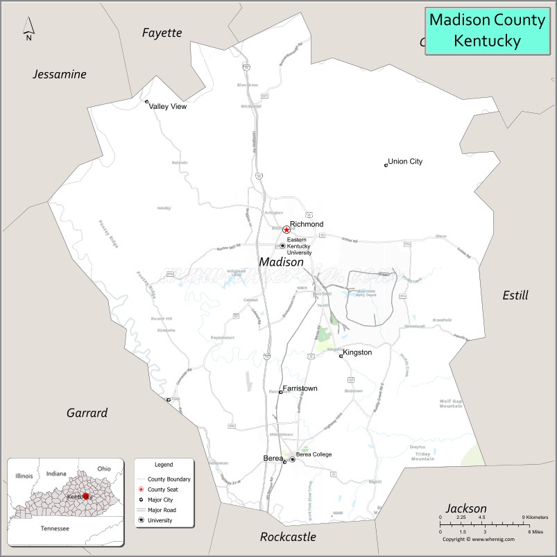
About Madison County Map, Kentucky: The map showing the county boundary, county seat, major cities, highways, water bodies and neighbouring counties.
More Kentucky Maps & Info
Map of Madison County, Kentucky
Madison County is a county located in the U.S. state of Kentucky. It's county seat is Richmond. As per 2020 census, the population of Madison County is 94666 people and population density is square miles. According to the United States Census Bureau, the county has a total area of 441 sq mi (1,142 km2). Madison County was established on 1785.
Madison County Facts
| Continent | North America |
| Country | United States |
| State | Kentucky |
| County Seat | Richmond |
| Largest City/Town | Richmond |
| Established | 1785 |
| Total Area | 443 sq mi (1,147 sq km) |
| Land Area | 437 sq mi (1,132 sq km) |
| Water Area | 6.0 sq mi (16 sq km) |
| Population | 92,701 (Census 2020) |
| Population Density | 212 people per sq mi |
| Time Zone | Eastern Time Zone (ET) |
| Major Highways | Interstate 75, U.S. Route 25, U.S. Route 421, Kentucky Route 52, Kentucky Route 876 |
| Major Rivers | Kentucky River |
| Neighboring Counties | Fayette County, Clark County, Estill County, Jackson County, Rockcastle County, Garrard County, Jessamine County |
| Famous For | Eastern Kentucky University, Civil War history, Berea arts community, and Bluegrass landscapes |
| Top Attractions | Fort Boonesborough State Park, Berea College, Richmond Battlefield Park, Kentucky Artisan Center, Lake Reba Recreation Complex |
| Official Website | Official Website |
About Madison County, Kentucky
Madison County is located in central Kentucky within the Bluegrass region and was established in 1785. The county seat and largest city is Richmond. Madison County is known for its educational institutions, Civil War history, arts and crafts traditions in Berea, scenic countryside, and outdoor recreation opportunities. ([en.wikipedia.org](https://en.wikipedia.org/wiki/Madison_County%2C_Kentucky?utm_source=chatgpt.com))
Cities and Communities in Madison County, Kentucky
| City/Town | Population | Latitude & Longitude |
|---|---|---|
| Richmond (county seat) | 34,000+ | 37.7479°N, 84.2947°W |
| Berea | 15,000+ | 37.5687°N, 84.2963°W |
| Waco | 200+ | 37.7370°N, 84.1430°W |
| Kirksville | Historic Community | 37.6637°N, 84.4315°W |
| Kingston | Rural Community | 37.6429°N, 84.2737°W |
| Valley View | Unincorporated | 37.7607°N, 84.3825°W |
| Big Hill | Historic Community | 37.5052°N, 84.1465°W |
| Speedwell | Rural Community | 37.6048°N, 84.2308°W |
Best Golf Courses in Madison County, Kentucky
| Golf Course | Location | Latitude & Longitude |
|---|---|---|
| Gibson Bay Golf Course | Richmond | 37.7660°N, 84.3018°W |
| Arlington Golf Club | Richmond | 37.7169°N, 84.3037°W |
| Boone Trace National Golf Club | Richmond Area | 37.6954°N, 84.2714°W |
| Berea Country Club | Berea | 37.5675°N, 84.2818°W |
What are Major Roads and Highways in Madison County
Major highways connect Madison County with Lexington, southeastern Kentucky, and regional Bluegrass communities.
- Interstate 75 - major north-south interstate corridor through Richmond and Berea
- U.S. Route 25 - historic highway serving central Kentucky communities
- U.S. Route 421 - important regional route through rural and urban areas
- Kentucky Route 52 - scenic roadway connecting eastern Kentucky regions
- Kentucky Route 876 - connector route around Richmond commercial districts
Neighboring Counties of Madison County
- Fayette County (north)
- Clark County (northeast)
- Estill County (east)
- Jackson County (southeast)
- Rockcastle County (south)
- Garrard County (west)
- Jessamine County (northwest)
What are Top Attractions in Madison County, Kentucky
The county offers historic parks, arts destinations, college attractions, and outdoor recreation areas.
| Main Sight Name | City | Famous For |
|---|---|---|
| Fort Boonesborough State Park | Richmond Area | Historic frontier fort and Kentucky pioneer history |
| Berea College | Berea | Historic liberal arts college and Appalachian crafts |
| Richmond Battlefield Park | Richmond | Civil War battlefield and historical exhibits |
| Kentucky Artisan Center | Berea | Regional arts, crafts, and cultural exhibits |
| Lake Reba Recreation Complex | Richmond | Fishing, trails, sports, and family recreation |
| Berea Pinnacles | Berea | Hiking trails and scenic overlooks |
| Old Town Berea | Berea | Art galleries, craft shops, and local dining |
| EKU Center for the Arts | Richmond | Performing arts and entertainment events |
| Battle of Richmond Visitors Center | Richmond | Civil War interpretation and exhibits |
| Kentucky River Scenic Areas | Countywide | Outdoor recreation and countryside scenery |
Distance from Madison County to Nearby Cities
The following distances are measured by road (driving).
- Richmond to Lexington, Kentucky - 26 mi (42 km)
- Richmond to Danville, Kentucky - 37 mi (60 km)
- Richmond to Louisville, Kentucky - 109 mi (175 km)
- Richmond to Cincinnati, Ohio - 99 mi (159 km)
- Richmond to Knoxville, Tennessee - 153 mi (246 km)
- Richmond to Charleston, West Virginia - 168 mi (270 km)
- Richmond to Nashville, Tennessee - 203 mi (327 km)
- Richmond to Columbus, Ohio - 185 mi (298 km)
- Richmond to Indianapolis, Indiana - 200 mi (322 km)
- Richmond to Atlanta, Georgia - 341 mi (549 km)
- Richmond to Chicago, Illinois - 347 mi (558 km)
- Richmond to St. Louis, Missouri - 331 mi (533 km)
References
- Madison County Official Website
- Madison County, Kentucky - Wikipedia
- U.S. Census Bureau QuickFacts
- Fort Boonesborough State Park
- Visit Berea Tourism
- Adair County Map
- Allen County Map
- Anderson County Map
- Ballard County Map
- Barren County Map
- Bath County Map
- Bell County Map
- Boone County Map
- Bourbon County Map
- Boyd County Map
- Boyle County Map
- Bracken County Map
- Breathitt County Map
- Breckinridge County Map
- Bullitt County Map
- Butler County Map
- Caldwell County Map
- Calloway County Map
- Campbell County Map
- Carlisle County Map
- Carroll County Map
- Carter County Map
- Casey County Map
- Christian County Map
- Clark County Map
- Clay County Map
- Clinton County Map
- Crittenden County Map
- Cumberland County Map
- Daviess County Map
- Edmonson County Map
- Elliott County Map
- Estill County Map
- Fayette County Map
- Fleming County Map
- Floyd County Map
- Franklin County Map
- Fulton County Map
- Gallatin County Map
- Garrard County Map
- Grant County Map
- Graves County Map
- Grayson County Map
- Green County Map
- Greenup County Map
- Hancock County Map
- Hardin County Map
- Harlan County Map
- Harrison County Map
- Hart County Map
- Henderson County Map
- Henry County Map
- Hickman County Map
- Hopkins County Map
- Jackson County Map
- Jefferson County Map
- Jessamine County Map
- Johnson County Map
- Kenton County Map
- Knott County Map
- Knox County Map
- LaRue County Map
- Laurel County Map
- Lawrence County Map
- Lee County Map
- Leslie County Map
- Letcher County Map
- Lewis County Map
- Lincoln County Map
- Livingston County Map
- Logan County Map
- Lyon County Map
- McCracken County Map
- McCreary County Map
- McLean County Map
- Madison County Map
- Magoffin County Map
- Marion County Map
- Marshall County Map
- Martin County Map
- Mason County Map
- Meade County Map
- Menifee County Map
- Mercer County Map
- Metcalfe County Map
- Monroe County Map
- Montgomery County Map
- Morgan County Map
- Muhlenberg County Map
- Nelson County Map
- Nicholas County Map
- Ohio County Map
- Oldham County Map
- Owen County Map
- Owsley County Map
- Pendleton County Map
- Perry County Map
- Pike County Map
- Powell County Map
- Pulaski County Map
- Robertson County Map
- Rockcastle County Map
- Rowan County Map
- Russell County Map
- Scott County Map
- Shelby County Map
- Simpson County Map
- Spencer County Map
- Taylor County Map
- Todd County Map
- Trigg County Map
- Trimble County Map
- Union County Map
- Warren County Map
- Washington County Map
- Wayne County Map
- Webster County Map
- Whitley County Map
- Wolfe County Map
- Woodford County Map
- Alabama Counties
- Alaska boroughs
- Arizona Counties
- Arkansas Counties
- California County Map
- Colorado Counties
- Connecticut Counties
- Delaware Counties
- Florida County Map
- Georgia County Map
- Hawaii Counties
- Idaho Counties
- Illinois Counties
- Indiana Counties
- Iowa Counties
- Kansas Counties
- Kentucky Counties
- Louisiana Counties
- Maine Counties
- Maryland Counties
- Massachusetts Counties
- Michigan County Map
- Minnesota Counties
- Mississippi Counties
- Missouri Counties
- Montana Counties
- Nebraska Counties
- Nevada Counties
- New York Counties
- New Hampshire Counties
- New Jersey Counties
- New Mexico Counties
- North Carolina Counties
- North Dakota Counties
- Ohio County Map
- Oklahoma Counties
- Oregon Counties
- Pennsylvania Counties
- Rhode Island Counties
- South Carolina Counties
- South Dakota Counties
- Map of Tennessee
- Texas County Map
- Utah Counties
- Vermont Counties
- Virginia Counties
- Washington Counties
- West Virginia Counties
- Wisconsin Counties
- Wyoming Counties