Map of Woodford County - Woodford County is a county located in the U.S. state of Kentucky. Woodford County Map showing cities, highways, important places and water bodies. Get Where is Woodford County located in the map, major cities in Woodford county, population, areas, and places of interest.
Map of Woodford County, Kentucky
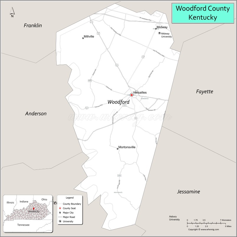
About Woodford County Map, Kentucky: The map showing the county boundary, county seat, major cities, highways, water bodies and neighbouring counties.
More Kentucky Maps & Info
Map of Woodford County, Kentucky
Woodford County is a county located in the U.S. state of Kentucky. It's county seat is Versailles. As per 2020 census, the population of Woodford County is 27075 people and population density is square miles. According to the United States Census Bureau, the county has a total area of 191 sq mi (495 km2). Woodford County was established on 1788.
Woodford County Facts
| Continent | North America |
| Country | United States |
| State | Kentucky |
| County Seat | Versailles |
| Largest City/Town | Versailles |
| Established | 1788 |
| Total Area | 192 sq mi (497 sq km) |
| Land Area | 191 sq mi (495 sq km) |
| Water Area | 0.8 sq mi (2 sq km) |
| Population | 26,871 (Census 2020) |
| Population Density | 141 people per sq mi |
| Time Zone | Eastern Time Zone (ET) |
| Major Highways | Interstate 64 nearby area, U.S. Route 60, Kentucky Route 33, Bluegrass Parkway nearby area |
| Major Rivers | Kentucky River |
| Neighboring Counties | Franklin County, Scott County, Fayette County, Jessamine County, Anderson County |
| Famous For | Horse farms, bourbon distilleries, Keeneland nearby area, and Bluegrass countryside |
| Top Attractions | Woodford Reserve Distillery, Castle & Key Distillery, Kentucky Castle nearby area, Downtown Versailles, Kentucky River Palisades |
| Official Website | Official Website |
About Woodford County, Kentucky
Woodford County is located in central Kentucky within the heart of the Bluegrass region and was established in 1788. The county seat and largest city is Versailles. Woodford County is internationally known for thoroughbred horse farms, bourbon distilleries, scenic rolling pastures, and its location within Kentucky’s famous Horse Country near Lexington and Keeneland Race Course. ([en.wikipedia.org](https://en.wikipedia.org/wiki/Woodford_County%2C_Kentucky?utm_source=chatgpt.com))
Cities and Communities in Woodford County, Kentucky
| City/Town | Population | Latitude & Longitude |
|---|---|---|
| Versailles (county seat) | 10,000+ | 38.0526°N, 84.7299°W |
| Midway | 1,800+ | 38.1506°N, 84.6841°W |
| Millville | Small Community | 38.0956°N, 84.6424°W |
| Mortonsville | Historic Community | 38.0062°N, 84.7768°W |
| Nonesuch | Rural Community | 38.1273°N, 84.8205°W |
| Jackstown | Agricultural Area | 38.0701°N, 84.7826°W |
| Big Sink | Scenic Area | 38.0019°N, 84.6908°W |
| Keeneland Nearby Area | Regional Community | 38.0472°N, 84.6050°W |
Best Golf Courses in Woodford County, Kentucky
| Golf Course | Location | Latitude & Longitude |
|---|---|---|
| The Woodford Club | Versailles | 38.0396°N, 84.7424°W |
| Cherry Blossom Golf Club | Nearby Georgetown | 38.2279°N, 84.5707°W |
| University Club of Kentucky | Nearby Lexington | 38.0171°N, 84.4514°W |
| Kearney Hill Golf Links | Nearby Lexington | 38.0893°N, 84.5417°W |
What are Major Roads and Highways in Woodford County
Major highways connect Woodford County with Lexington, Louisville, and important Kentucky Horse Country destinations.
- Interstate 64 nearby area - major interstate linking Lexington and Louisville
- U.S. Route 60 - scenic highway through Versailles and Midway
- Kentucky Route 33 - regional connector serving horse farms and rural communities
- Bluegrass Parkway nearby area - transportation corridor connecting central Kentucky regions
Neighboring Counties of Woodford County
- Franklin County (west)
- Scott County (north)
- Fayette County (east)
- Jessamine County (south)
- Anderson County (southwest)
What are Top Attractions in Woodford County, Kentucky
The county offers bourbon tourism, horse farm scenery, historic architecture, Bluegrass landscapes, and world-famous Kentucky attractions.
| Main Sight Name | City | Famous For |
|---|---|---|
| Woodford Reserve Distillery | Versailles Area | Bourbon tours and historic whiskey production |
| Castle & Key Distillery | Versailles Area | Historic bourbon distillery and scenic grounds |
| Kentucky Castle Nearby Area | Versailles Area | Luxury lodging, dining, and castle-style architecture |
| Downtown Versailles | Versailles | Historic courthouse square and local shops |
| Kentucky River Palisades | Countywide | Scenic cliffs and nature photography |
| Horse Farm Scenic Drives | Countywide | Thoroughbred farms and rolling Bluegrass pastures |
| Midway Historic District | Midway | Railroad heritage and boutique shopping |
| Keeneland Nearby Area | Regional Area | Horse racing and equestrian traditions |
| Bluegrass Countryside | Countywide | Scenic drives and photography opportunities |
| Community Festivals and Events | Versailles Area | Seasonal celebrations and local traditions |
Distance from Woodford County to Nearby Cities
The following distances are measured by road (driving).
- Versailles to Lexington, Kentucky - 16 mi (26 km)
- Versailles to Frankfort, Kentucky - 15 mi (24 km)
- Versailles to Louisville, Kentucky - 56 mi (90 km)
- Versailles to Georgetown, Kentucky - 27 mi (43 km)
- Versailles to Cincinnati, Ohio - 91 mi (146 km)
- Versailles to Bowling Green, Kentucky - 125 mi (201 km)
- Versailles to Indianapolis, Indiana - 170 mi (274 km)
- Versailles to Nashville, Tennessee - 212 mi (341 km)
- Versailles to Columbus, Ohio - 204 mi (328 km)
- Versailles to Knoxville, Tennessee - 188 mi (303 km)
- Versailles to Chicago, Illinois - 320 mi (515 km)
- Versailles to Atlanta, Georgia - 356 mi (573 km)
References
- Woodford County Official Website
- Woodford County, Kentucky - Wikipedia
- U.S. Census Bureau QuickFacts
- Woodford Reserve Distillery
- Explore Woodford County Tourism
- Adair County Map
- Allen County Map
- Anderson County Map
- Ballard County Map
- Barren County Map
- Bath County Map
- Bell County Map
- Boone County Map
- Bourbon County Map
- Boyd County Map
- Boyle County Map
- Bracken County Map
- Breathitt County Map
- Breckinridge County Map
- Bullitt County Map
- Butler County Map
- Caldwell County Map
- Calloway County Map
- Campbell County Map
- Carlisle County Map
- Carroll County Map
- Carter County Map
- Casey County Map
- Christian County Map
- Clark County Map
- Clay County Map
- Clinton County Map
- Crittenden County Map
- Cumberland County Map
- Daviess County Map
- Edmonson County Map
- Elliott County Map
- Estill County Map
- Fayette County Map
- Fleming County Map
- Floyd County Map
- Franklin County Map
- Fulton County Map
- Gallatin County Map
- Garrard County Map
- Grant County Map
- Graves County Map
- Grayson County Map
- Green County Map
- Greenup County Map
- Hancock County Map
- Hardin County Map
- Harlan County Map
- Harrison County Map
- Hart County Map
- Henderson County Map
- Henry County Map
- Hickman County Map
- Hopkins County Map
- Jackson County Map
- Jefferson County Map
- Jessamine County Map
- Johnson County Map
- Kenton County Map
- Knott County Map
- Knox County Map
- LaRue County Map
- Laurel County Map
- Lawrence County Map
- Lee County Map
- Leslie County Map
- Letcher County Map
- Lewis County Map
- Lincoln County Map
- Livingston County Map
- Logan County Map
- Lyon County Map
- McCracken County Map
- McCreary County Map
- McLean County Map
- Madison County Map
- Magoffin County Map
- Marion County Map
- Marshall County Map
- Martin County Map
- Mason County Map
- Meade County Map
- Menifee County Map
- Mercer County Map
- Metcalfe County Map
- Monroe County Map
- Montgomery County Map
- Morgan County Map
- Muhlenberg County Map
- Nelson County Map
- Nicholas County Map
- Ohio County Map
- Oldham County Map
- Owen County Map
- Owsley County Map
- Pendleton County Map
- Perry County Map
- Pike County Map
- Powell County Map
- Pulaski County Map
- Robertson County Map
- Rockcastle County Map
- Rowan County Map
- Russell County Map
- Scott County Map
- Shelby County Map
- Simpson County Map
- Spencer County Map
- Taylor County Map
- Todd County Map
- Trigg County Map
- Trimble County Map
- Union County Map
- Warren County Map
- Washington County Map
- Wayne County Map
- Webster County Map
- Whitley County Map
- Wolfe County Map
- Woodford County Map
- Alabama Counties
- Alaska boroughs
- Arizona Counties
- Arkansas Counties
- California County Map
- Colorado Counties
- Connecticut Counties
- Delaware Counties
- Florida County Map
- Georgia County Map
- Hawaii Counties
- Idaho Counties
- Illinois Counties
- Indiana Counties
- Iowa Counties
- Kansas Counties
- Kentucky Counties
- Louisiana Counties
- Maine Counties
- Maryland Counties
- Massachusetts Counties
- Michigan County Map
- Minnesota Counties
- Mississippi Counties
- Missouri Counties
- Montana Counties
- Nebraska Counties
- Nevada Counties
- New York Counties
- New Hampshire Counties
- New Jersey Counties
- New Mexico Counties
- North Carolina Counties
- North Dakota Counties
- Ohio County Map
- Oklahoma Counties
- Oregon Counties
- Pennsylvania Counties
- Rhode Island Counties
- South Carolina Counties
- South Dakota Counties
- Map of Tennessee
- Texas County Map
- Utah Counties
- Vermont Counties
- Virginia Counties
- Washington Counties
- West Virginia Counties
- Wisconsin Counties
- Wyoming Counties