Map of McLean County - McLean County is a county located in the U.S. state of Kentucky. McLean County Map showing cities, highways, important places and water bodies. Get Where is McLean County located in the map, major cities in McLean county, population, areas, and places of interest.
Map of McLean County, Kentucky
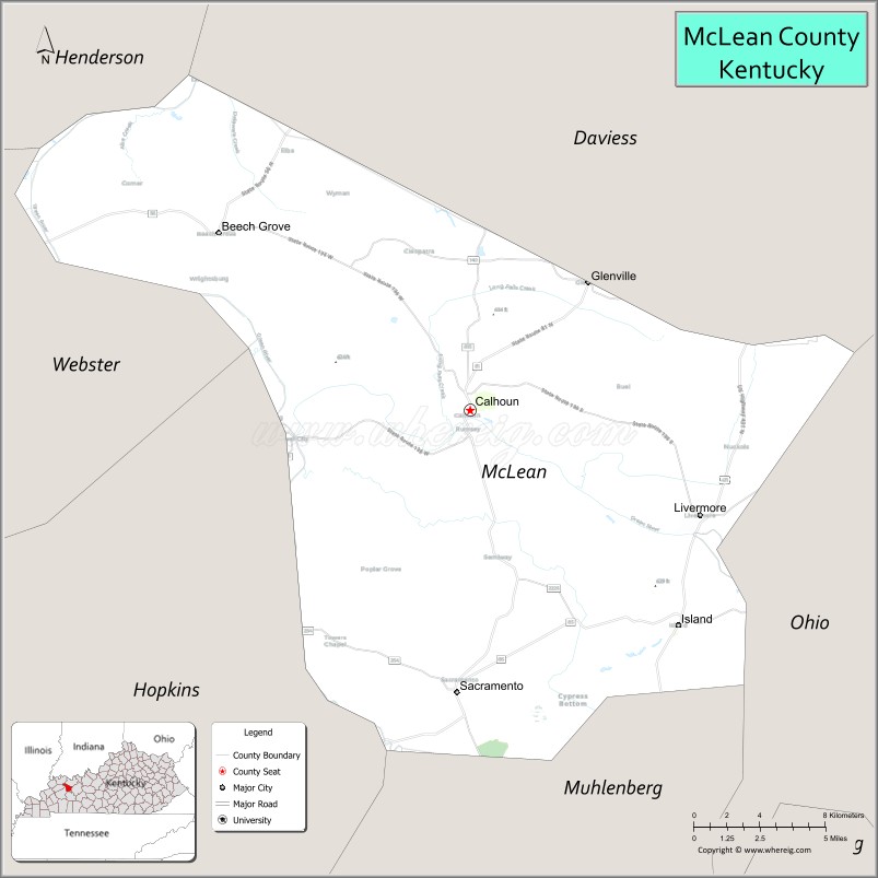
About McLean County Map, Kentucky: The map showing the county boundary, county seat, major cities, highways, water bodies and neighbouring counties.
More Kentucky Maps & Info
Map of McLean County, Kentucky
McLean County is a county located in the U.S. state of Kentucky. It's county seat is Calhoun. As per 2020 census, the population of McLean County is 9100 people and population density is square miles. According to the United States Census Bureau, the county has a total area of 254 sq mi (658 km2). McLean County was established on 1854.
McLean County Facts
| Continent | North America |
| Country | United States |
| State | Kentucky |
| County Seat | Calhoun |
| Largest City/Town | Livermore |
| Established | 1854 |
| Total Area | 255 sq mi (660 sq km) |
| Land Area | 252 sq mi (653 sq km) |
| Water Area | 2.5 sq mi (7 sq km) |
| Population | 9,152 (Census 2020) |
| Population Density | 36 people per sq mi |
| Time Zone | Central Time Zone (CT) |
| Major Highways | Kentucky Route 81, Kentucky Route 85, Kentucky Route 136, Kentucky Route 256 |
| Major Rivers | Green River, Rough River |
| Neighboring Counties | Daviess County, Ohio County, Muhlenberg County, Webster County |
| Famous For | Green River scenery, Civil War history, agriculture, and western Kentucky rural heritage |
| Top Attractions | Battle of Sacramento Historic Site, Green River recreation, Livermore Bridge area, McLean County Museum, scenic byways |
| Official Website | Official Website |
About McLean County, Kentucky
McLean County is located in western Kentucky within the Western Coal Fields region and was established in 1854 from portions of Daviess, Ohio, and Muhlenberg counties. The county seat is Calhoun while Livermore is the largest city. McLean County is known for scenic Green River landscapes, agricultural communities, Civil War heritage, and small-town western Kentucky culture. :contentReference[oaicite:0]{index=0}
Cities and Communities in McLean County, Kentucky
| City/Town | Population | Latitude & Longitude |
|---|---|---|
| Calhoun (county seat) | 700+ | 37.5381°N, 87.2661°W |
| Livermore | 1,200+ | 37.4939°N, 87.1319°W |
| Sacramento | 400+ | 37.4167°N, 87.2664°W |
| Island | 400+ | 37.4428°N, 87.1450°W |
| Beech Grove | Unincorporated Community | 37.5994°N, 87.0105°W |
| Rumsey | Historic Community | 37.5347°N, 87.2895°W |
| Glenville | Rural Community | 37.4562°N, 87.2101°W |
| Buttonsberry | Small Community | 37.4986°N, 87.3075°W |
Best Golf Courses in McLean County, Kentucky
| Golf Course | Location | Latitude & Longitude |
|---|---|---|
| Owensboro Country Club | Nearby Owensboro | 37.7514°N, 87.0824°W |
| Ben Hawes Golf Course | Nearby Owensboro | 37.7285°N, 87.1662°W |
| Madisonville Country Club | Nearby Madisonville | 37.3445°N, 87.5171°W |
| Central City Country Club | Nearby Central City | 37.2898°N, 87.1304°W |
What are Major Roads and Highways in McLean County
Major highways connect McLean County with Owensboro, western Kentucky agricultural regions, and nearby river communities.
- Kentucky Route 81 - important regional highway through Calhoun and Livermore
- Kentucky Route 85 - connector roadway serving rural farming communities
- Kentucky Route 136 - scenic route across western Kentucky countryside
- Kentucky Route 256 - regional roadway connecting riverfront communities
Neighboring Counties of McLean County
- Daviess County (north)
- Ohio County (east)
- Muhlenberg County (south)
- Webster County (west)
What are Top Attractions in McLean County, Kentucky
The county offers river recreation, Civil War history, scenic countryside, and small-town western Kentucky attractions. :contentReference[oaicite:1]{index=1}
| Main Sight Name | City | Famous For |
|---|---|---|
| Battle of Sacramento Historic Site | Sacramento | Civil War battlefield and annual reenactments |
| Green River Recreation | Countywide | Fishing, boating, and riverside scenery |
| Livermore Bridge Area | Livermore | Historic bridge crossing Green and Rough rivers |
| McLean County Museum | Calhoun | Regional history and cultural exhibits |
| Kentucky Scenic Byway Routes | Countywide | Countryside drives and photography |
| Rumsey Riverfront Area | Rumsey | Historic river community scenery |
| Island Wooden Bridge Festival Area | Island | Community events and local heritage |
| Livermore Downtown Area | Livermore | Historic small-town atmosphere |
| Rural Farmland Scenic Drives | Countywide | Agricultural landscapes and open countryside |
| Community Heritage Festivals | Countywide | Seasonal celebrations and local traditions |
Distance from McLean County to Nearby Cities
The following distances are measured by road (driving).
- Calhoun to Owensboro, Kentucky - 27 mi (43 km)
- Calhoun to Madisonville, Kentucky - 38 mi (61 km)
- Calhoun to Bowling Green, Kentucky - 84 mi (135 km)
- Calhoun to Evansville, Indiana - 55 mi (89 km)
- Calhoun to Louisville, Kentucky - 116 mi (187 km)
- Calhoun to Nashville, Tennessee - 129 mi (208 km)
- Calhoun to Paducah, Kentucky - 104 mi (167 km)
- Calhoun to Indianapolis, Indiana - 181 mi (291 km)
- Calhoun to St. Louis, Missouri - 205 mi (330 km)
- Calhoun to Cincinnati, Ohio - 223 mi (359 km)
- Calhoun to Memphis, Tennessee - 228 mi (367 km)
- Calhoun to Chicago, Illinois - 324 mi (521 km)
References
- McLean County Official Website
- McLean County Tourism
- U.S. Census Bureau QuickFacts
- McLean County, Kentucky - Wikipedia
- Kentucky Atlas - McLean County
- Adair County Map
- Allen County Map
- Anderson County Map
- Ballard County Map
- Barren County Map
- Bath County Map
- Bell County Map
- Boone County Map
- Bourbon County Map
- Boyd County Map
- Boyle County Map
- Bracken County Map
- Breathitt County Map
- Breckinridge County Map
- Bullitt County Map
- Butler County Map
- Caldwell County Map
- Calloway County Map
- Campbell County Map
- Carlisle County Map
- Carroll County Map
- Carter County Map
- Casey County Map
- Christian County Map
- Clark County Map
- Clay County Map
- Clinton County Map
- Crittenden County Map
- Cumberland County Map
- Daviess County Map
- Edmonson County Map
- Elliott County Map
- Estill County Map
- Fayette County Map
- Fleming County Map
- Floyd County Map
- Franklin County Map
- Fulton County Map
- Gallatin County Map
- Garrard County Map
- Grant County Map
- Graves County Map
- Grayson County Map
- Green County Map
- Greenup County Map
- Hancock County Map
- Hardin County Map
- Harlan County Map
- Harrison County Map
- Hart County Map
- Henderson County Map
- Henry County Map
- Hickman County Map
- Hopkins County Map
- Jackson County Map
- Jefferson County Map
- Jessamine County Map
- Johnson County Map
- Kenton County Map
- Knott County Map
- Knox County Map
- LaRue County Map
- Laurel County Map
- Lawrence County Map
- Lee County Map
- Leslie County Map
- Letcher County Map
- Lewis County Map
- Lincoln County Map
- Livingston County Map
- Logan County Map
- Lyon County Map
- McCracken County Map
- McCreary County Map
- McLean County Map
- Madison County Map
- Magoffin County Map
- Marion County Map
- Marshall County Map
- Martin County Map
- Mason County Map
- Meade County Map
- Menifee County Map
- Mercer County Map
- Metcalfe County Map
- Monroe County Map
- Montgomery County Map
- Morgan County Map
- Muhlenberg County Map
- Nelson County Map
- Nicholas County Map
- Ohio County Map
- Oldham County Map
- Owen County Map
- Owsley County Map
- Pendleton County Map
- Perry County Map
- Pike County Map
- Powell County Map
- Pulaski County Map
- Robertson County Map
- Rockcastle County Map
- Rowan County Map
- Russell County Map
- Scott County Map
- Shelby County Map
- Simpson County Map
- Spencer County Map
- Taylor County Map
- Todd County Map
- Trigg County Map
- Trimble County Map
- Union County Map
- Warren County Map
- Washington County Map
- Wayne County Map
- Webster County Map
- Whitley County Map
- Wolfe County Map
- Woodford County Map
- Alabama Counties
- Alaska boroughs
- Arizona Counties
- Arkansas Counties
- California County Map
- Colorado Counties
- Connecticut Counties
- Delaware Counties
- Florida County Map
- Georgia County Map
- Hawaii Counties
- Idaho Counties
- Illinois Counties
- Indiana Counties
- Iowa Counties
- Kansas Counties
- Kentucky Counties
- Louisiana Counties
- Maine Counties
- Maryland Counties
- Massachusetts Counties
- Michigan County Map
- Minnesota Counties
- Mississippi Counties
- Missouri Counties
- Montana Counties
- Nebraska Counties
- Nevada Counties
- New York Counties
- New Hampshire Counties
- New Jersey Counties
- New Mexico Counties
- North Carolina Counties
- North Dakota Counties
- Ohio County Map
- Oklahoma Counties
- Oregon Counties
- Pennsylvania Counties
- Rhode Island Counties
- South Carolina Counties
- South Dakota Counties
- Map of Tennessee
- Texas County Map
- Utah Counties
- Vermont Counties
- Virginia Counties
- Washington Counties
- West Virginia Counties
- Wisconsin Counties
- Wyoming Counties