Map of Union County - Union County is a county located in the U.S. state of Kentucky. Union County Map showing cities, highways, important places and water bodies. Get Where is Union County located in the map, major cities in Union county, population, areas, and places of interest.
Map of Union County, Kentucky
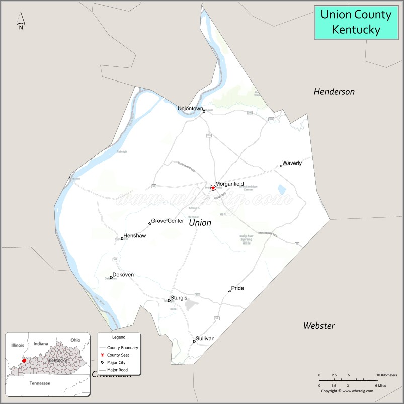
About Union County Map, Kentucky: The map showing the county boundary, county seat, major cities, highways, water bodies and neighbouring counties.
More Kentucky Maps & Info
Map of Union County, Kentucky
Union County is a county located in the U.S. state of Kentucky. It's county seat is Morganfield. As per 2020 census, the population of Union County is 13544 people and population density is square miles. According to the United States Census Bureau, the county has a total area of 345 sq mi (894 km2). Union County was established on 1811.
Union County Facts
| Continent | North America |
| Country | United States |
| State | Kentucky |
| County Seat | Morganfield |
| Largest City/Town | Morganfield |
| Established | 1811 |
| Total Area | 363 sq mi (940 sq km) |
| Land Area | 343 sq mi (888 sq km) |
| Water Area | 20 sq mi (52 sq km) |
| Population | 13,668 (Census 2020) |
| Population Density | 40 people per sq mi |
| Time Zone | Central Time Zone (CT) |
| Major Highways | U.S. Route 60, Kentucky Route 56, Kentucky Route 109, Kentucky Route 141 |
| Major Rivers | Ohio River, Tradewater River |
| Neighboring Counties | Henderson County, Webster County, Crittenden County, Hardin County (IL), Gallatin County (IL), Posey County (IN) |
| Famous For | Coal mining, agriculture, Ohio River commerce, and western Kentucky river landscapes |
| Top Attractions | John James Audubon State Park nearby area, Union County Museum, Ohio River recreation areas, Historic Morganfield, Higginson-Henry Wildlife Management Area |
| Official Website | Official Website |
About Union County, Kentucky
Union County is located in western Kentucky along the Ohio River and was established in 1811. The county seat and largest city is Morganfield. Union County is known for its strong agricultural economy, coal mining history, river transportation, and scenic landscapes along the Ohio River and Tradewater River valleys. :contentReference[oaicite:0]{index=0}
Cities and Communities in Union County, Kentucky
| City/Town | Population | Latitude & Longitude |
|---|---|---|
| Morganfield (county seat) | 3,000+ | 37.6831°N, 87.9150°W |
| Sturgis | 1,800+ | 37.5462°N, 87.9836°W |
| Uniontown | 900+ | 37.7745°N, 87.9317°W |
| Waverly | 300+ | 37.6600°N, 87.8153°W |
| Sullivan | Rural Community | 37.7198°N, 87.9858°W |
| Henshaw | Historic Community | 37.6220°N, 87.9394°W |
| Pride | Agricultural Area | 37.7441°N, 87.8462°W |
| Raleigh Nearby Area | Regional Community | 37.6584°N, 87.7607°W |
Best Golf Courses in Union County, Kentucky
| Golf Course | Location | Latitude & Longitude |
|---|---|---|
| Rolling Hills Country Club | Morganfield | 37.6794°N, 87.9115°W |
| Ellis Park Golf Course | Nearby Henderson | 37.8428°N, 87.5678°W |
| Camden Golf Club | Nearby Owensboro | 37.7643°N, 87.1121°W |
| Quail Crossing Golf Club | Nearby Boonville, IN | 38.0497°N, 87.2818°W |
What are Major Roads and Highways in Union County
Major highways connect Union County with western Kentucky river communities, Indiana, Illinois, and important agricultural and industrial corridors.
- U.S. Route 60 - major east-west highway through Morganfield and Uniontown
- Kentucky Route 56 - regional roadway serving riverfront communities and farmland
- Kentucky Route 109 - north-south connector linking western Kentucky counties
- Kentucky Route 141 - scenic route through rural landscapes and mining regions
Neighboring Counties of Union County
- Henderson County (north)
- Webster County (east)
- Crittenden County (south)
- Hardin County, Illinois (west)
- Gallatin County, Illinois (northwest)
- Posey County, Indiana (north across the Ohio River)
What are Top Attractions in Union County, Kentucky
The county offers river recreation, museums, wildlife areas, scenic countryside, and historic western Kentucky communities. :contentReference[oaicite:1]{index=1}
| Main Sight Name | City | Famous For |
|---|---|---|
| John James Audubon State Park Nearby Area | Regional Area | Nature trails, museum exhibits, and wildlife viewing |
| Union County Museum | Morganfield | Local history and regional heritage exhibits |
| Ohio River Recreation Areas | Countywide | Fishing, boating, and river scenery |
| Historic Morganfield | Morganfield | Historic courthouse square and local shops |
| Higginson-Henry Wildlife Management Area | Countywide | Hunting, wildlife viewing, and outdoor recreation |
| Tradewater River Areas | Countywide | Nature photography and quiet recreation |
| Sturgis Historic Areas | Sturgis | Coal mining heritage and local history |
| Western Kentucky Scenic Drives | Countywide | Farmland and river valley landscapes |
| Community Festivals and Events | Morganfield Area | Seasonal celebrations and county traditions |
| Outdoor Nature Trails | Countywide | Birdwatching and hiking opportunities |
Distance from Union County to Nearby Cities
The following distances are measured by road (driving).
- Morganfield to Henderson, Kentucky - 26 mi (42 km)
- Morganfield to Evansville, Indiana - 36 mi (58 km)
- Morganfield to Owensboro, Kentucky - 51 mi (82 km)
- Morganfield to Paducah, Kentucky - 88 mi (142 km)
- Morganfield to Nashville, Tennessee - 157 mi (253 km)
- Morganfield to Louisville, Kentucky - 154 mi (248 km)
- Morganfield to St. Louis, Missouri - 171 mi (275 km)
- Morganfield to Indianapolis, Indiana - 194 mi (312 km)
- Morganfield to Memphis, Tennessee - 230 mi (370 km)
- Morganfield to Cincinnati, Ohio - 236 mi (380 km)
- Morganfield to Chicago, Illinois - 311 mi (500 km)
- Morganfield to Atlanta, Georgia - 377 mi (607 km)
References
- Union County Official Website
- Union County, Kentucky - Wikipedia
- U.S. Census Bureau QuickFacts
- John James Audubon State Park
- Union County History
- Adair County Map
- Allen County Map
- Anderson County Map
- Ballard County Map
- Barren County Map
- Bath County Map
- Bell County Map
- Boone County Map
- Bourbon County Map
- Boyd County Map
- Boyle County Map
- Bracken County Map
- Breathitt County Map
- Breckinridge County Map
- Bullitt County Map
- Butler County Map
- Caldwell County Map
- Calloway County Map
- Campbell County Map
- Carlisle County Map
- Carroll County Map
- Carter County Map
- Casey County Map
- Christian County Map
- Clark County Map
- Clay County Map
- Clinton County Map
- Crittenden County Map
- Cumberland County Map
- Daviess County Map
- Edmonson County Map
- Elliott County Map
- Estill County Map
- Fayette County Map
- Fleming County Map
- Floyd County Map
- Franklin County Map
- Fulton County Map
- Gallatin County Map
- Garrard County Map
- Grant County Map
- Graves County Map
- Grayson County Map
- Green County Map
- Greenup County Map
- Hancock County Map
- Hardin County Map
- Harlan County Map
- Harrison County Map
- Hart County Map
- Henderson County Map
- Henry County Map
- Hickman County Map
- Hopkins County Map
- Jackson County Map
- Jefferson County Map
- Jessamine County Map
- Johnson County Map
- Kenton County Map
- Knott County Map
- Knox County Map
- LaRue County Map
- Laurel County Map
- Lawrence County Map
- Lee County Map
- Leslie County Map
- Letcher County Map
- Lewis County Map
- Lincoln County Map
- Livingston County Map
- Logan County Map
- Lyon County Map
- McCracken County Map
- McCreary County Map
- McLean County Map
- Madison County Map
- Magoffin County Map
- Marion County Map
- Marshall County Map
- Martin County Map
- Mason County Map
- Meade County Map
- Menifee County Map
- Mercer County Map
- Metcalfe County Map
- Monroe County Map
- Montgomery County Map
- Morgan County Map
- Muhlenberg County Map
- Nelson County Map
- Nicholas County Map
- Ohio County Map
- Oldham County Map
- Owen County Map
- Owsley County Map
- Pendleton County Map
- Perry County Map
- Pike County Map
- Powell County Map
- Pulaski County Map
- Robertson County Map
- Rockcastle County Map
- Rowan County Map
- Russell County Map
- Scott County Map
- Shelby County Map
- Simpson County Map
- Spencer County Map
- Taylor County Map
- Todd County Map
- Trigg County Map
- Trimble County Map
- Union County Map
- Warren County Map
- Washington County Map
- Wayne County Map
- Webster County Map
- Whitley County Map
- Wolfe County Map
- Woodford County Map
- Alabama Counties
- Alaska boroughs
- Arizona Counties
- Arkansas Counties
- California County Map
- Colorado Counties
- Connecticut Counties
- Delaware Counties
- Florida County Map
- Georgia County Map
- Hawaii Counties
- Idaho Counties
- Illinois Counties
- Indiana Counties
- Iowa Counties
- Kansas Counties
- Kentucky Counties
- Louisiana Counties
- Maine Counties
- Maryland Counties
- Massachusetts Counties
- Michigan County Map
- Minnesota Counties
- Mississippi Counties
- Missouri Counties
- Montana Counties
- Nebraska Counties
- Nevada Counties
- New York Counties
- New Hampshire Counties
- New Jersey Counties
- New Mexico Counties
- North Carolina Counties
- North Dakota Counties
- Ohio County Map
- Oklahoma Counties
- Oregon Counties
- Pennsylvania Counties
- Rhode Island Counties
- South Carolina Counties
- South Dakota Counties
- Map of Tennessee
- Texas County Map
- Utah Counties
- Vermont Counties
- Virginia Counties
- Washington Counties
- West Virginia Counties
- Wisconsin Counties
- Wyoming Counties