Map of Pulaski County - Pulaski County is a county located in the U.S. state of Kentucky. Pulaski County Map showing cities, highways, important places and water bodies. Get Where is Pulaski County located in the map, major cities in Pulaski county, population, areas, and places of interest.
Map of Pulaski County, Kentucky
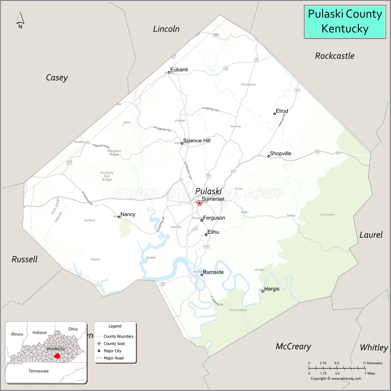
About Pulaski County Map, Kentucky: The map showing the county boundary, county seat, major cities, highways, water bodies and neighbouring counties.
More Kentucky Maps & Info
Map of Pulaski County, Kentucky
Pulaski County is a county located in the U.S. state of Kentucky. It's county seat is Somerset. As per 2020 census, the population of Pulaski County is 65423 people and population density is square miles. According to the United States Census Bureau, the county has a total area of 662 sq mi (1,715 km2). Pulaski County was established on 1798.
Pulaski County Facts
| Continent | North America |
| Country | United States |
| State | Kentucky |
| County Seat | Somerset |
| Largest City/Town | Somerset |
| Established | 1798 |
| Total Area | 677 sq mi (1,753 sq km) |
| Land Area | 658 sq mi (1,704 sq km) |
| Water Area | 19 sq mi (49 sq km) |
| Population | 65,034 (Census 2020) |
| Population Density | 99 people per sq mi |
| Time Zone | Eastern Time Zone (ET) |
| Major Highways | U.S. Route 27, Kentucky Route 80, Cumberland Parkway nearby area, Kentucky Route 914 |
| Major Rivers | Cumberland River |
| Neighboring Counties | Lincoln County, Rockcastle County, Laurel County, McCreary County, Wayne County, Russell County, Casey County |
| Famous For | Lake Cumberland, houseboat tourism, Somerset festivals, and outdoor recreation in southern Kentucky |
| Top Attractions | Lake Cumberland, SomerSplash Waterpark, General Burnside Island State Park, Downtown Somerset, Mill Springs Battlefield nearby area |
| Official Website | Official Website |
About Pulaski County, Kentucky
Pulaski County is located in south-central Kentucky and was established in 1798. The county seat and largest city is Somerset. Pulaski County is widely known for Lake Cumberland, one of the largest man-made lakes in the eastern United States, attracting visitors for boating, fishing, camping, and houseboat tourism while also serving as an important commercial and cultural center of southern Kentucky. ([en.wikipedia.org](https://en.wikipedia.org/wiki/Pulaski_County%2C_Kentucky?utm_source=chatgpt.com))
Cities and Communities in Pulaski County, Kentucky
| City/Town | Population | Latitude & Longitude |
|---|---|---|
| Somerset (county seat) | 11,000+ | 37.0923°N, 84.6041°W |
| Burnside | 700+ | 36.9881°N, 84.5997°W |
| Science Hill | 700+ | 37.1770°N, 84.6402°W |
| Eubank | 300+ | 37.2790°N, 84.6591°W |
| Nancy | Lake Community | 37.0706°N, 84.7983°W |
| Ferguson | Historic Community | 37.0561°N, 84.6132°W |
| Shopville | Rural Community | 36.9889°N, 84.4652°W |
| Tateville | Lakeside Area | 36.8974°N, 84.4701°W |
Best Golf Courses in Pulaski County, Kentucky
| Golf Course | Location | Latitude & Longitude |
|---|---|---|
| General Burnside Island Golf Course | Burnside | 36.9932°N, 84.6084°W |
| Waitsboro Hills Golf Course | Somerset | 37.0308°N, 84.6653°W |
| Eagle's Nest Country Club | Somerset | 37.1164°N, 84.6261°W |
| Dale Hollow Lake State Resort Park Golf Course | Nearby Burkesville | 36.7907°N, 85.3112°W |
What are Major Roads and Highways in Pulaski County
Major highways connect Pulaski County with central Kentucky, Tennessee, and major recreation destinations around Lake Cumberland.
- U.S. Route 27 - major north-south corridor through Somerset and southern Kentucky
- Kentucky Route 80 - important east-west highway serving regional commerce and tourism
- Cumberland Parkway nearby area - major transportation route linking south-central Kentucky communities
- Kentucky Route 914 - bypass and connector route around Somerset commercial areas
Neighboring Counties of Pulaski County
- Lincoln County (north)
- Rockcastle County (northeast)
- Laurel County (east)
- McCreary County (southeast)
- Wayne County (southwest)
- Russell County (west)
- Casey County (northwest)
What are Top Attractions in Pulaski County, Kentucky
The county offers lake recreation, parks, historic landmarks, festivals, and family-friendly southern Kentucky attractions.
| Main Sight Name | City | Famous For |
|---|---|---|
| Lake Cumberland | Countywide | Boating, fishing, marinas, and houseboat tourism |
| SomerSplash Waterpark | Somerset | Family water attractions and summer recreation |
| General Burnside Island State Park | Burnside | Golf, camping, boating, and lake scenery |
| Downtown Somerset | Somerset | Historic shops, restaurants, and festivals |
| Mill Springs Battlefield Nearby Area | Regional Area | Civil War history and preserved battlefield |
| Pulaski County Park | Nancy Area | Lakeside recreation and camping |
| Lake Cumberland Winery | Nancy | Wine tastings and vineyard scenery |
| Fishing and Marina Areas | Countywide | Outdoor recreation and boating access |
| Master Musicians Festival | Somerset | Annual music festival and regional entertainment |
| Scenic Cumberland Lake Drives | Countywide | Lakeside photography and countryside views |
Distance from Pulaski County to Nearby Cities
The following distances are measured by road (driving).
- Somerset to Lexington, Kentucky - 76 mi (122 km)
- Somerset to Knoxville, Tennessee - 103 mi (166 km)
- Somerset to Louisville, Kentucky - 145 mi (233 km)
- Somerset to Nashville, Tennessee - 165 mi (266 km)
- Somerset to Bowling Green, Kentucky - 113 mi (182 km)
- Somerset to Cincinnati, Ohio - 181 mi (291 km)
- Somerset to Chattanooga, Tennessee - 213 mi (343 km)
- Somerset to Columbus, Ohio - 255 mi (410 km)
- Somerset to Indianapolis, Indiana - 257 mi (414 km)
- Somerset to Atlanta, Georgia - 291 mi (468 km)
- Somerset to Charleston, West Virginia - 250 mi (402 km)
- Somerset to Chicago, Illinois - 392 mi (631 km)
References
- Pulaski County Official Website
- Pulaski County, Kentucky - Wikipedia
- U.S. Census Bureau QuickFacts
- General Burnside Island State Park
- Kentucky Tourism
- Adair County Map
- Allen County Map
- Anderson County Map
- Ballard County Map
- Barren County Map
- Bath County Map
- Bell County Map
- Boone County Map
- Bourbon County Map
- Boyd County Map
- Boyle County Map
- Bracken County Map
- Breathitt County Map
- Breckinridge County Map
- Bullitt County Map
- Butler County Map
- Caldwell County Map
- Calloway County Map
- Campbell County Map
- Carlisle County Map
- Carroll County Map
- Carter County Map
- Casey County Map
- Christian County Map
- Clark County Map
- Clay County Map
- Clinton County Map
- Crittenden County Map
- Cumberland County Map
- Daviess County Map
- Edmonson County Map
- Elliott County Map
- Estill County Map
- Fayette County Map
- Fleming County Map
- Floyd County Map
- Franklin County Map
- Fulton County Map
- Gallatin County Map
- Garrard County Map
- Grant County Map
- Graves County Map
- Grayson County Map
- Green County Map
- Greenup County Map
- Hancock County Map
- Hardin County Map
- Harlan County Map
- Harrison County Map
- Hart County Map
- Henderson County Map
- Henry County Map
- Hickman County Map
- Hopkins County Map
- Jackson County Map
- Jefferson County Map
- Jessamine County Map
- Johnson County Map
- Kenton County Map
- Knott County Map
- Knox County Map
- LaRue County Map
- Laurel County Map
- Lawrence County Map
- Lee County Map
- Leslie County Map
- Letcher County Map
- Lewis County Map
- Lincoln County Map
- Livingston County Map
- Logan County Map
- Lyon County Map
- McCracken County Map
- McCreary County Map
- McLean County Map
- Madison County Map
- Magoffin County Map
- Marion County Map
- Marshall County Map
- Martin County Map
- Mason County Map
- Meade County Map
- Menifee County Map
- Mercer County Map
- Metcalfe County Map
- Monroe County Map
- Montgomery County Map
- Morgan County Map
- Muhlenberg County Map
- Nelson County Map
- Nicholas County Map
- Ohio County Map
- Oldham County Map
- Owen County Map
- Owsley County Map
- Pendleton County Map
- Perry County Map
- Pike County Map
- Powell County Map
- Pulaski County Map
- Robertson County Map
- Rockcastle County Map
- Rowan County Map
- Russell County Map
- Scott County Map
- Shelby County Map
- Simpson County Map
- Spencer County Map
- Taylor County Map
- Todd County Map
- Trigg County Map
- Trimble County Map
- Union County Map
- Warren County Map
- Washington County Map
- Wayne County Map
- Webster County Map
- Whitley County Map
- Wolfe County Map
- Woodford County Map
- Alabama Counties
- Alaska boroughs
- Arizona Counties
- Arkansas Counties
- California County Map
- Colorado Counties
- Connecticut Counties
- Delaware Counties
- Florida County Map
- Georgia County Map
- Hawaii Counties
- Idaho Counties
- Illinois Counties
- Indiana Counties
- Iowa Counties
- Kansas Counties
- Kentucky Counties
- Louisiana Counties
- Maine Counties
- Maryland Counties
- Massachusetts Counties
- Michigan County Map
- Minnesota Counties
- Mississippi Counties
- Missouri Counties
- Montana Counties
- Nebraska Counties
- Nevada Counties
- New York Counties
- New Hampshire Counties
- New Jersey Counties
- New Mexico Counties
- North Carolina Counties
- North Dakota Counties
- Ohio County Map
- Oklahoma Counties
- Oregon Counties
- Pennsylvania Counties
- Rhode Island Counties
- South Carolina Counties
- South Dakota Counties
- Map of Tennessee
- Texas County Map
- Utah Counties
- Vermont Counties
- Virginia Counties
- Washington Counties
- West Virginia Counties
- Wisconsin Counties
- Wyoming Counties