Map of Green County - Green County is a county located in the U.S. state of Kentucky. Green County Map showing cities, highways, important places and water bodies. Get Where is Green County located in the map, major cities in Green county, population, areas, and places of interest.
Map of Green County, Kentucky
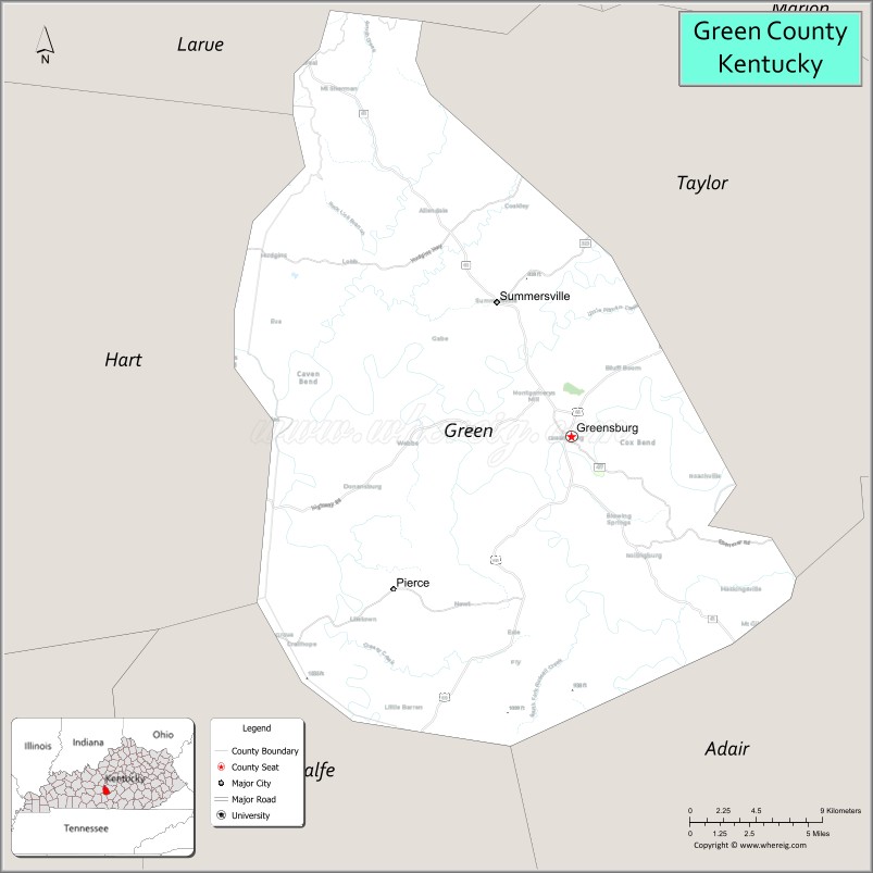
About Green County Map, Kentucky: The map showing the county boundary, county seat, major cities, highways, water bodies and neighbouring counties.
More Kentucky Maps & Info
Map of Green County, Kentucky
Green County is a county located in the U.S. state of Kentucky. It's county seat is Greensburg. As per 2020 census, the population of Green County is 11291 people and population density is square miles. According to the United States Census Bureau, the county has a total area of 289 sq mi (749 km2). Green County was established on 1792.
Green County Facts
| Continent | North America |
| Country | United States |
| State | Kentucky |
| County Seat | Greensburg |
| Largest City/Town | Greensburg |
| Established | 1792 |
| Total Area | 289 sq mi (749 sq km) |
| Land Area | 289 sq mi (748 sq km) |
| Water Area | 0.5 sq mi (1 sq km) |
| Population | 11,107 (Census 2020) |
| Population Density | 38 people per sq mi |
| Time Zone | Central Time Zone (CT) |
| Major Highways | U.S. Route 68, Kentucky Route 61, Kentucky Route 55, Kentucky Route 218 |
| Major Rivers | Green River |
| Neighboring Counties | Taylor County, Adair County, Hart County, Metcalfe County, LaRue County |
| Famous For | Green River heritage, historic courthouse, rural Kentucky farmland, and Bluegrass traditions |
| Top Attractions | Downtown Greensburg Historic District, Green River Lake nearby area, Green County Courthouse, Jane Todd Crawford Hospital Museum, Veterans Memorial Park |
| Official Website | Official Website |
About Green County, Kentucky
Green County is located in central Kentucky and was established in 1792, making it one of the older counties in the state. The county seat and largest city is Greensburg. Green County is known for its agricultural heritage, scenic Green River landscapes, historic downtown architecture, and strong rural Kentucky traditions. :contentReference[oaicite:0]{index=0}
Cities and Communities in Green County, Kentucky
| City/Town | Population | Latitude & Longitude |
|---|---|---|
| Greensburg (county seat) | 2,100+ | 37.2601°N, 85.4986°W |
| Summersville | 600+ | 37.3278°N, 85.3475°W |
| Greaney | Unincorporated | 37.1684°N, 85.5122°W |
| Pierce | Historic Community | 37.2752°N, 85.5840°W |
| Exie | Rural Community | 37.2004°N, 85.3747°W |
| Cave Ridge | Unincorporated | 37.3345°N, 85.5158°W |
| Donansburg | Historic Community | 37.1736°N, 85.6088°W |
| Saint Charles | Rural Community | 37.2999°N, 85.4312°W |
Best Golf Courses in Green County, Kentucky
| Golf Course | Location | Latitude & Longitude |
|---|---|---|
| Lincoln Homestead State Park Golf Course | Nearby Springfield | 37.6929°N, 85.2289°W |
| Maywood Country Club | Nearby Bardstown | 37.8171°N, 85.4418°W |
| Heartland Golf Club | Nearby Elizabethtown | 37.7154°N, 85.8610°W |
| Lakewood Country Club | Nearby Russell Springs | 37.0592°N, 85.0764°W |
What are Major Roads and Highways in Green County
Major highways connect Green County with central Kentucky communities and surrounding agricultural regions.
- U.S. Route 68 - major east-west highway serving Greensburg and nearby counties
- Kentucky Route 61 - important north-south roadway connecting rural communities
- Kentucky Route 55 - regional route linking Green County with central Kentucky cities
- Kentucky Route 218 - scenic roadway through countryside and farming areas
Neighboring Counties of Green County
- Taylor County (north)
- Adair County (south)
- Hart County (west)
- Metcalfe County (southwest)
- LaRue County (northwest)
What are Top Attractions in Green County, Kentucky
The county offers historic sites, river recreation, rural scenery, and cultural attractions connected to Kentucky heritage.
| Main Sight Name | City | Famous For |
|---|---|---|
| Downtown Greensburg Historic District | Greensburg | Historic architecture and local heritage |
| Green River Lake Nearby Area | Regional Area | Fishing, boating, and outdoor recreation |
| Green County Courthouse | Greensburg | Historic courthouse and community landmark |
| Jane Todd Crawford Hospital Museum | Greensburg | Medical history and pioneer heritage |
| Veterans Memorial Park | Greensburg | Community events and memorial displays |
| Green River Scenic Areas | Countywide | Nature photography and river landscapes |
| Historic Churches | Countywide | Early Kentucky pioneer architecture |
| Rural Scenic Drives | Countywide | Farmland views and rolling countryside |
| Community Festivals | Greensburg Area | Local traditions and cultural events |
| Outdoor Recreation Areas | Countywide | Camping, hiking, and wildlife viewing |
Distance from Green County to Nearby Cities
The following distances are measured by road (driving).
- Greensburg to Campbellsville, Kentucky - 19 mi (31 km)
- Greensburg to Elizabethtown, Kentucky - 66 mi (106 km)
- Greensburg to Bowling Green, Kentucky - 71 mi (114 km)
- Greensburg to Louisville, Kentucky - 88 mi (142 km)
- Greensburg to Lexington, Kentucky - 96 mi (154 km)
- Greensburg to Nashville, Tennessee - 126 mi (203 km)
- Greensburg to Owensboro, Kentucky - 111 mi (179 km)
- Greensburg to Cincinnati, Ohio - 174 mi (280 km)
- Greensburg to Indianapolis, Indiana - 191 mi (307 km)
- Greensburg to Knoxville, Tennessee - 193 mi (311 km)
- Greensburg to St. Louis, Missouri - 287 mi (462 km)
- Greensburg to Atlanta, Georgia - 321 mi (517 km)
References
- Green County Official Website
- Green County, Kentucky - Wikipedia
- U.S. Census Bureau QuickFacts
- Kentucky Tourism
- City of Greensburg
- Adair County Map
- Allen County Map
- Anderson County Map
- Ballard County Map
- Barren County Map
- Bath County Map
- Bell County Map
- Boone County Map
- Bourbon County Map
- Boyd County Map
- Boyle County Map
- Bracken County Map
- Breathitt County Map
- Breckinridge County Map
- Bullitt County Map
- Butler County Map
- Caldwell County Map
- Calloway County Map
- Campbell County Map
- Carlisle County Map
- Carroll County Map
- Carter County Map
- Casey County Map
- Christian County Map
- Clark County Map
- Clay County Map
- Clinton County Map
- Crittenden County Map
- Cumberland County Map
- Daviess County Map
- Edmonson County Map
- Elliott County Map
- Estill County Map
- Fayette County Map
- Fleming County Map
- Floyd County Map
- Franklin County Map
- Fulton County Map
- Gallatin County Map
- Garrard County Map
- Grant County Map
- Graves County Map
- Grayson County Map
- Green County Map
- Greenup County Map
- Hancock County Map
- Hardin County Map
- Harlan County Map
- Harrison County Map
- Hart County Map
- Henderson County Map
- Henry County Map
- Hickman County Map
- Hopkins County Map
- Jackson County Map
- Jefferson County Map
- Jessamine County Map
- Johnson County Map
- Kenton County Map
- Knott County Map
- Knox County Map
- LaRue County Map
- Laurel County Map
- Lawrence County Map
- Lee County Map
- Leslie County Map
- Letcher County Map
- Lewis County Map
- Lincoln County Map
- Livingston County Map
- Logan County Map
- Lyon County Map
- McCracken County Map
- McCreary County Map
- McLean County Map
- Madison County Map
- Magoffin County Map
- Marion County Map
- Marshall County Map
- Martin County Map
- Mason County Map
- Meade County Map
- Menifee County Map
- Mercer County Map
- Metcalfe County Map
- Monroe County Map
- Montgomery County Map
- Morgan County Map
- Muhlenberg County Map
- Nelson County Map
- Nicholas County Map
- Ohio County Map
- Oldham County Map
- Owen County Map
- Owsley County Map
- Pendleton County Map
- Perry County Map
- Pike County Map
- Powell County Map
- Pulaski County Map
- Robertson County Map
- Rockcastle County Map
- Rowan County Map
- Russell County Map
- Scott County Map
- Shelby County Map
- Simpson County Map
- Spencer County Map
- Taylor County Map
- Todd County Map
- Trigg County Map
- Trimble County Map
- Union County Map
- Warren County Map
- Washington County Map
- Wayne County Map
- Webster County Map
- Whitley County Map
- Wolfe County Map
- Woodford County Map
- Alabama Counties
- Alaska boroughs
- Arizona Counties
- Arkansas Counties
- California County Map
- Colorado Counties
- Connecticut Counties
- Delaware Counties
- Florida County Map
- Georgia County Map
- Hawaii Counties
- Idaho Counties
- Illinois Counties
- Indiana Counties
- Iowa Counties
- Kansas Counties
- Kentucky Counties
- Louisiana Counties
- Maine Counties
- Maryland Counties
- Massachusetts Counties
- Michigan County Map
- Minnesota Counties
- Mississippi Counties
- Missouri Counties
- Montana Counties
- Nebraska Counties
- Nevada Counties
- New York Counties
- New Hampshire Counties
- New Jersey Counties
- New Mexico Counties
- North Carolina Counties
- North Dakota Counties
- Ohio County Map
- Oklahoma Counties
- Oregon Counties
- Pennsylvania Counties
- Rhode Island Counties
- South Carolina Counties
- South Dakota Counties
- Map of Tennessee
- Texas County Map
- Utah Counties
- Vermont Counties
- Virginia Counties
- Washington Counties
- West Virginia Counties
- Wisconsin Counties
- Wyoming Counties