Map of Russell County - Russell County is a county located in the U.S. state of Kentucky. Russell County Map showing cities, highways, important places and water bodies. Get Where is Russell County located in the map, major cities in Russell county, population, areas, and places of interest.
Map of Russell County, Kentucky
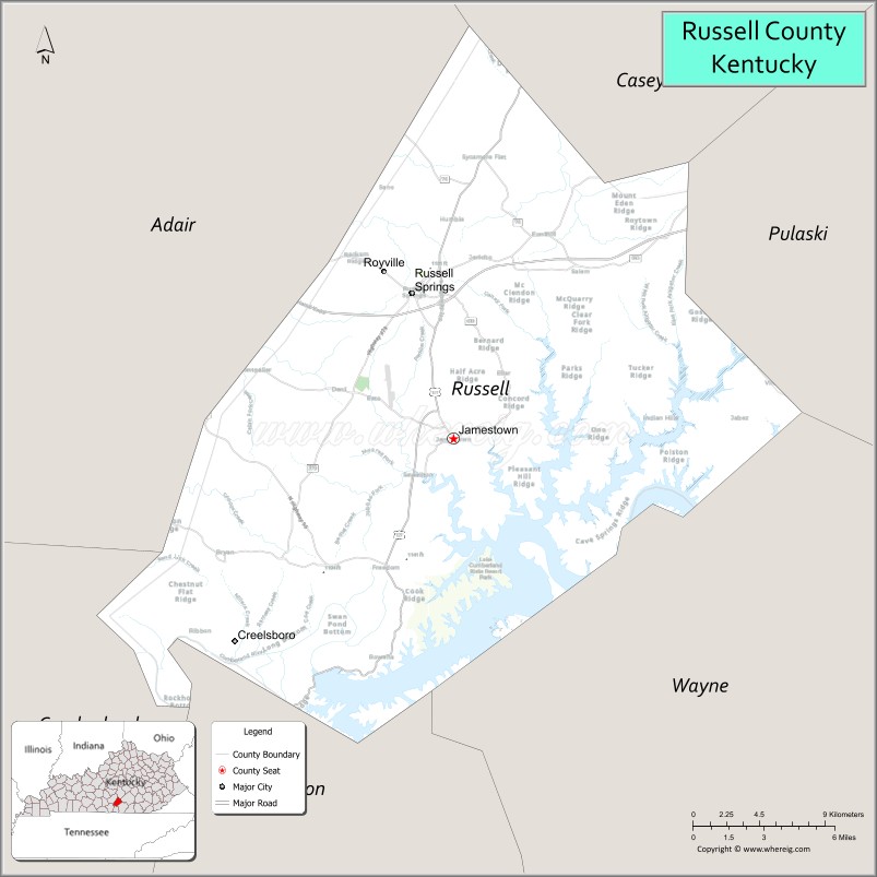
About Russell County Map, Kentucky: The map showing the county boundary, county seat, major cities, highways, water bodies and neighbouring counties.
More Kentucky Maps & Info
Map of Russell County, Kentucky
Russell County is a county located in the U.S. state of Kentucky. It's county seat is Jamestown. As per 2020 census, the population of Russell County is 18156 people and population density is square miles. According to the United States Census Bureau, the county has a total area of 254 sq mi (658 km2). Russell County was established on 1825.
Russell County Facts
| Continent | North America |
| Country | United States |
| State | Kentucky |
| County Seat | Jamestown |
| Largest City/Town | Russell Springs |
| Established | 1825 |
| Total Area | 283 sq mi (733 sq km) |
| Land Area | 254 sq mi (658 sq km) |
| Water Area | 29 sq mi (75 sq km) |
| Population | 17,991 (Census 2020) |
| Population Density | 71 people per sq mi |
| Time Zone | Central Time Zone (CT) |
| Major Highways | Cumberland Parkway, U.S. Route 127, Kentucky Route 80, Kentucky Route 379 |
| Major Rivers | Cumberland River |
| Neighboring Counties | Casey County, Pulaski County, Wayne County, Clinton County, Cumberland County, Adair County |
| Famous For | Lake Cumberland, Wolf Creek Dam, boating tourism, fishing, and outdoor recreation |
| Top Attractions | Lake Cumberland, Wolf Creek Dam, Lake Cumberland State Resort Park, Wolf Creek National Fish Hatchery, Jamestown Marina |
| Official Website | Official Website |
About Russell County, Kentucky
Russell County is located in south-central Kentucky near the Tennessee border and was established in 1825. The county seat is Jamestown while Russell Springs is the largest city. Russell County is widely known for Lake Cumberland, one of the largest recreational lakes in the eastern United States, attracting visitors for boating, fishing, camping, and houseboat tourism throughout the year. :contentReference[oaicite:0]{index=0}
Cities and Communities in Russell County, Kentucky
| City/Town | Population | Latitude & Longitude |
|---|---|---|
| Russell Springs | 2,700+ | 37.0567°N, 85.0891°W |
| Jamestown (county seat) | 1,800+ | 36.9823°N, 85.0630°W |
| Rowena | Historic Community | 36.8794°N, 85.1108°W |
| Eli | Rural Community | 37.0413°N, 85.0185°W |
| Esto | Small Community | 37.1025°N, 85.0591°W |
| Fonthill | Lakeside Area | 36.9698°N, 85.1430°W |
| Sewellton | Rural Area | 37.0242°N, 85.1784°W |
| Creelsboro | Historic River Community | 36.9436°N, 85.0205°W |
Best Golf Courses in Russell County, Kentucky
| Golf Course | Location | Latitude & Longitude |
|---|---|---|
| Lakewood Country Club | Russell Springs | 37.0264°N, 85.0777°W |
| Lake Cumberland State Resort Park Golf Area | Jamestown Area | 36.9481°N, 85.0983°W |
| General Burnside Island Golf Course | Nearby Burnside | 36.9932°N, 84.6084°W |
| Dale Hollow Lake State Resort Park Golf Course | Nearby Burkesville | 36.7907°N, 85.3112°W |
What are Major Roads and Highways in Russell County
Major highways connect Russell County with Lake Cumberland recreation areas and major regional transportation corridors. :contentReference[oaicite:1]{index=1}
- Cumberland Parkway - major east-west route linking south-central Kentucky communities
- U.S. Route 127 - important north-south corridor through Jamestown and Russell Springs
- Kentucky Route 80 - regional highway connecting tourism and commercial areas
- Kentucky Route 379 - scenic route serving Lake Cumberland recreation destinations
Neighboring Counties of Russell County
- Casey County (north)
- Pulaski County (northeast)
- Wayne County (southeast)
- Clinton County (south)
- Cumberland County (southwest)
- Adair County (west)
What are Top Attractions in Russell County, Kentucky
The county offers lake recreation, marinas, parks, fishing destinations, and scenic outdoor attractions centered around Lake Cumberland. :contentReference[oaicite:2]{index=2}
| Main Sight Name | City | Famous For |
|---|---|---|
| Lake Cumberland | Countywide | Boating, fishing, marinas, and houseboat vacations |
| Wolf Creek Dam | Jamestown Area | Massive dam and scenic Cumberland River views |
| Lake Cumberland State Resort Park | Jamestown | Camping, lodging, hiking, and lake recreation |
| Wolf Creek National Fish Hatchery | Jamestown Area | Fish conservation and educational exhibits |
| Jamestown Marina | Jamestown | Boat rentals and waterfront recreation |
| Russell Springs City Park | Russell Springs | Family recreation and community events |
| Lakewood Country Club | Russell Springs | Golf and outdoor recreation |
| Creelsboro Historic Area | Creelsboro | Historic river community and scenic countryside |
| Mini Indy Go Kart Track | Jamestown Area | Family entertainment and recreation |
| Stephens Classic Car Museum | Russell Springs | Vintage automobiles and local history |
Distance from Russell County to Nearby Cities
The following distances are measured by road (driving).
- Jamestown to Somerset, Kentucky - 33 mi (53 km)
- Jamestown to Bowling Green, Kentucky - 87 mi (140 km)
- Jamestown to Lexington, Kentucky - 117 mi (188 km)
- Jamestown to Nashville, Tennessee - 129 mi (208 km)
- Jamestown to Louisville, Kentucky - 145 mi (233 km)
- Jamestown to Knoxville, Tennessee - 164 mi (264 km)
- Jamestown to Cincinnati, Ohio - 221 mi (356 km)
- Jamestown to Chattanooga, Tennessee - 231 mi (372 km)
- Jamestown to Indianapolis, Indiana - 260 mi (418 km)
- Jamestown to Atlanta, Georgia - 316 mi (509 km)
- Jamestown to Columbus, Ohio - 295 mi (475 km)
- Jamestown to Chicago, Illinois - 391 mi (629 km)
References
- Russell County Fiscal Court
- Russell County, Kentucky - Wikipedia
- U.S. Census Bureau QuickFacts
- Lake Cumberland Attractions
- Russell County Industrial Development Authority
- Adair County Map
- Allen County Map
- Anderson County Map
- Ballard County Map
- Barren County Map
- Bath County Map
- Bell County Map
- Boone County Map
- Bourbon County Map
- Boyd County Map
- Boyle County Map
- Bracken County Map
- Breathitt County Map
- Breckinridge County Map
- Bullitt County Map
- Butler County Map
- Caldwell County Map
- Calloway County Map
- Campbell County Map
- Carlisle County Map
- Carroll County Map
- Carter County Map
- Casey County Map
- Christian County Map
- Clark County Map
- Clay County Map
- Clinton County Map
- Crittenden County Map
- Cumberland County Map
- Daviess County Map
- Edmonson County Map
- Elliott County Map
- Estill County Map
- Fayette County Map
- Fleming County Map
- Floyd County Map
- Franklin County Map
- Fulton County Map
- Gallatin County Map
- Garrard County Map
- Grant County Map
- Graves County Map
- Grayson County Map
- Green County Map
- Greenup County Map
- Hancock County Map
- Hardin County Map
- Harlan County Map
- Harrison County Map
- Hart County Map
- Henderson County Map
- Henry County Map
- Hickman County Map
- Hopkins County Map
- Jackson County Map
- Jefferson County Map
- Jessamine County Map
- Johnson County Map
- Kenton County Map
- Knott County Map
- Knox County Map
- LaRue County Map
- Laurel County Map
- Lawrence County Map
- Lee County Map
- Leslie County Map
- Letcher County Map
- Lewis County Map
- Lincoln County Map
- Livingston County Map
- Logan County Map
- Lyon County Map
- McCracken County Map
- McCreary County Map
- McLean County Map
- Madison County Map
- Magoffin County Map
- Marion County Map
- Marshall County Map
- Martin County Map
- Mason County Map
- Meade County Map
- Menifee County Map
- Mercer County Map
- Metcalfe County Map
- Monroe County Map
- Montgomery County Map
- Morgan County Map
- Muhlenberg County Map
- Nelson County Map
- Nicholas County Map
- Ohio County Map
- Oldham County Map
- Owen County Map
- Owsley County Map
- Pendleton County Map
- Perry County Map
- Pike County Map
- Powell County Map
- Pulaski County Map
- Robertson County Map
- Rockcastle County Map
- Rowan County Map
- Russell County Map
- Scott County Map
- Shelby County Map
- Simpson County Map
- Spencer County Map
- Taylor County Map
- Todd County Map
- Trigg County Map
- Trimble County Map
- Union County Map
- Warren County Map
- Washington County Map
- Wayne County Map
- Webster County Map
- Whitley County Map
- Wolfe County Map
- Woodford County Map
- Alabama Counties
- Alaska boroughs
- Arizona Counties
- Arkansas Counties
- California County Map
- Colorado Counties
- Connecticut Counties
- Delaware Counties
- Florida County Map
- Georgia County Map
- Hawaii Counties
- Idaho Counties
- Illinois Counties
- Indiana Counties
- Iowa Counties
- Kansas Counties
- Kentucky Counties
- Louisiana Counties
- Maine Counties
- Maryland Counties
- Massachusetts Counties
- Michigan County Map
- Minnesota Counties
- Mississippi Counties
- Missouri Counties
- Montana Counties
- Nebraska Counties
- Nevada Counties
- New York Counties
- New Hampshire Counties
- New Jersey Counties
- New Mexico Counties
- North Carolina Counties
- North Dakota Counties
- Ohio County Map
- Oklahoma Counties
- Oregon Counties
- Pennsylvania Counties
- Rhode Island Counties
- South Carolina Counties
- South Dakota Counties
- Map of Tennessee
- Texas County Map
- Utah Counties
- Vermont Counties
- Virginia Counties
- Washington Counties
- West Virginia Counties
- Wisconsin Counties
- Wyoming Counties