Map of Simpson County - Simpson County is a county located in the U.S. state of Kentucky. Simpson County Map showing cities, highways, important places and water bodies. Get Where is Simpson County located in the map, major cities in Simpson county, population, areas, and places of interest.
Map of Simpson County, Kentucky
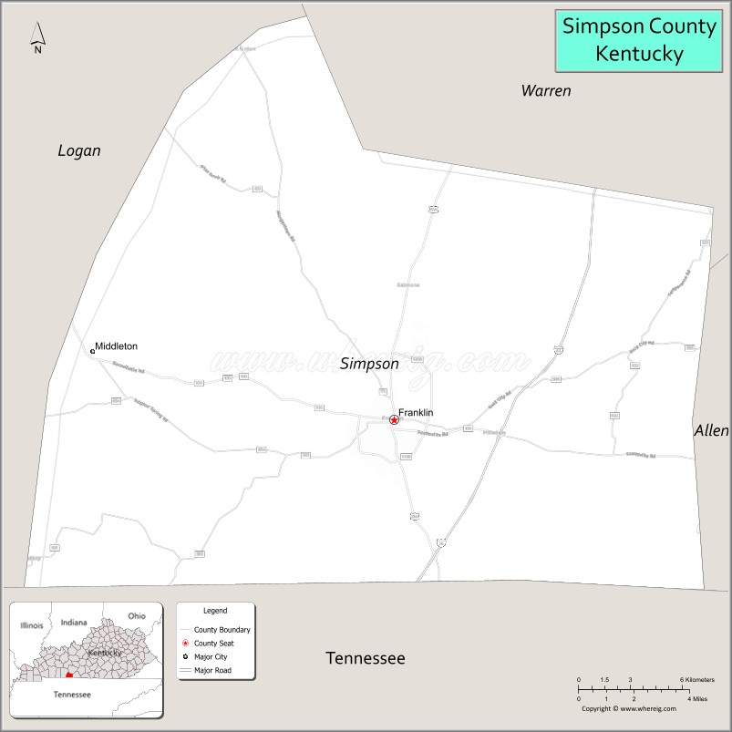
About Simpson County Map, Kentucky: The map showing the county boundary, county seat, major cities, highways, water bodies and neighbouring counties.
More Kentucky Maps & Info
Map of Simpson County, Kentucky
Simpson County is a county located in the U.S. state of Kentucky. It's county seat is Franklin. As per 2020 census, the population of Simpson County is 19718 people and population density is square miles. According to the United States Census Bureau, the county has a total area of 236 sq mi (611 km2). Simpson County was established on 1819.
Simpson County Facts
| Continent | North America |
| Country | United States |
| State | Kentucky |
| County Seat | Franklin |
| Largest City/Town | Franklin |
| Established | 1819 |
| Total Area | 236 sq mi (611 sq km) |
| Land Area | 234 sq mi (606 sq km) |
| Water Area | 2.3 sq mi (6 sq km) |
| Population | 19,594 (Census 2020) |
| Population Density | 84 people per sq mi |
| Time Zone | Central Time Zone (CT) |
| Major Highways | Interstate 65, U.S. Route 31W, Kentucky Route 100, Kentucky Route 73 |
| Major Rivers | Drakes Creek, Red River tributaries |
| Neighboring Counties | Logan County, Warren County, Allen County, Sumner County (TN) |
| Famous For | Historic Franklin, southern Kentucky agriculture, proximity to Nashville, and antique shopping |
| Top Attractions | Kenny Perry's Country Creek Golf Course, Historic Downtown Franklin, Octagon Hall Museum, Simpson County Archives Museum, Drakes Creek recreation areas |
| Official Website | Official Website |
About Simpson County, Kentucky
Simpson County is located in south-central Kentucky along the Tennessee border and was established in 1819. The county seat and largest city is Franklin. Simpson County is known for historic small-town charm, agricultural traditions, antique shopping, and its strategic location along Interstate 65 between Bowling Green and Nashville. ([en.wikipedia.org](https://en.wikipedia.org/wiki/Simpson_County%2C_Kentucky?utm_source=chatgpt.com))
Cities and Communities in Simpson County, Kentucky
| City/Town | Population | Latitude & Longitude |
|---|---|---|
| Franklin (county seat) | 10,000+ | 36.7223°N, 86.5772°W |
| Woodburn | 300+ | 36.8420°N, 86.5311°W |
| Gold City | Rural Community | 36.6787°N, 86.4712°W |
| Prices Mill | Historic Community | 36.7551°N, 86.6188°W |
| Mitchellville Nearby Area | Regional Community | 36.6509°N, 86.5163°W |
| Middleton | Agricultural Area | 36.7834°N, 86.5519°W |
| Salmons | Unincorporated | 36.7279°N, 86.4476°W |
| Black Jack | Rural Area | 36.7068°N, 86.6505°W |
Best Golf Courses in Simpson County, Kentucky
| Golf Course | Location | Latitude & Longitude |
|---|---|---|
| Kenny Perry's Country Creek Golf Course | Franklin | 36.7448°N, 86.5825°W |
| Franklin Country Club | Franklin | 36.7197°N, 86.5862°W |
| CrossWinds Golf Course | Nearby Bowling Green | 36.9348°N, 86.4287°W |
| The Club at Olde Stone | Nearby Bowling Green | 36.9505°N, 86.3812°W |
What are Major Roads and Highways in Simpson County
Major highways connect Simpson County with Bowling Green, Nashville, and important south-central Kentucky transportation corridors.
- Interstate 65 - major north-south interstate connecting Louisville and Nashville
- U.S. Route 31W - historic regional highway through Franklin and surrounding communities
- Kentucky Route 100 - important east-west route serving agricultural areas
- Kentucky Route 73 - local connector roadway linking rural communities
Neighboring Counties of Simpson County
- Logan County (west)
- Warren County (north)
- Allen County (east)
- Sumner County, Tennessee (south)
What are Top Attractions in Simpson County, Kentucky
The county offers historic attractions, golf courses, museums, antique shopping, and scenic southern Kentucky countryside experiences.
| Main Sight Name | City | Famous For |
|---|---|---|
| Kenny Perry's Country Creek Golf Course | Franklin | Championship golf designed by PGA golfer Kenny Perry |
| Historic Downtown Franklin | Franklin | Antique shops, restaurants, and historic architecture |
| Octagon Hall Museum | Franklin Area | Historic Civil War-era mansion and museum |
| Simpson County Archives Museum | Franklin | Local history and genealogy exhibits |
| Drakes Creek Recreation Areas | Countywide | Fishing, nature scenery, and outdoor recreation |
| Kenny Perry Birthplace Heritage Areas | Franklin Area | Local sports history and community pride |
| Historic Franklin Square | Franklin | Classic Kentucky courthouse square atmosphere |
| Southern Kentucky Scenic Drives | Countywide | Farmland views and countryside photography |
| Community Festivals and Events | Franklin Area | Seasonal entertainment and local traditions |
| Rural Agricultural Landscapes | Countywide | Traditional Kentucky farming scenery |
Distance from Simpson County to Nearby Cities
The following distances are measured by road (driving).
- Franklin to Bowling Green, Kentucky - 22 mi (35 km)
- Franklin to Nashville, Tennessee - 43 mi (69 km)
- Franklin to Clarksville, Tennessee - 67 mi (108 km)
- Franklin to Louisville, Kentucky - 154 mi (248 km)
- Franklin to Lexington, Kentucky - 168 mi (270 km)
- Franklin to Evansville, Indiana - 130 mi (209 km)
- Franklin to Chattanooga, Tennessee - 146 mi (235 km)
- Franklin to Knoxville, Tennessee - 199 mi (320 km)
- Franklin to Memphis, Tennessee - 222 mi (357 km)
- Franklin to Indianapolis, Indiana - 254 mi (409 km)
- Franklin to Atlanta, Georgia - 257 mi (414 km)
- Franklin to Cincinnati, Ohio - 248 mi (399 km)
References
- Simpson County Official Website
- Simpson County, Kentucky - Wikipedia
- U.S. Census Bureau QuickFacts
- City of Franklin, Kentucky
- Kentucky Tourism
- Adair County Map
- Allen County Map
- Anderson County Map
- Ballard County Map
- Barren County Map
- Bath County Map
- Bell County Map
- Boone County Map
- Bourbon County Map
- Boyd County Map
- Boyle County Map
- Bracken County Map
- Breathitt County Map
- Breckinridge County Map
- Bullitt County Map
- Butler County Map
- Caldwell County Map
- Calloway County Map
- Campbell County Map
- Carlisle County Map
- Carroll County Map
- Carter County Map
- Casey County Map
- Christian County Map
- Clark County Map
- Clay County Map
- Clinton County Map
- Crittenden County Map
- Cumberland County Map
- Daviess County Map
- Edmonson County Map
- Elliott County Map
- Estill County Map
- Fayette County Map
- Fleming County Map
- Floyd County Map
- Franklin County Map
- Fulton County Map
- Gallatin County Map
- Garrard County Map
- Grant County Map
- Graves County Map
- Grayson County Map
- Green County Map
- Greenup County Map
- Hancock County Map
- Hardin County Map
- Harlan County Map
- Harrison County Map
- Hart County Map
- Henderson County Map
- Henry County Map
- Hickman County Map
- Hopkins County Map
- Jackson County Map
- Jefferson County Map
- Jessamine County Map
- Johnson County Map
- Kenton County Map
- Knott County Map
- Knox County Map
- LaRue County Map
- Laurel County Map
- Lawrence County Map
- Lee County Map
- Leslie County Map
- Letcher County Map
- Lewis County Map
- Lincoln County Map
- Livingston County Map
- Logan County Map
- Lyon County Map
- McCracken County Map
- McCreary County Map
- McLean County Map
- Madison County Map
- Magoffin County Map
- Marion County Map
- Marshall County Map
- Martin County Map
- Mason County Map
- Meade County Map
- Menifee County Map
- Mercer County Map
- Metcalfe County Map
- Monroe County Map
- Montgomery County Map
- Morgan County Map
- Muhlenberg County Map
- Nelson County Map
- Nicholas County Map
- Ohio County Map
- Oldham County Map
- Owen County Map
- Owsley County Map
- Pendleton County Map
- Perry County Map
- Pike County Map
- Powell County Map
- Pulaski County Map
- Robertson County Map
- Rockcastle County Map
- Rowan County Map
- Russell County Map
- Scott County Map
- Shelby County Map
- Simpson County Map
- Spencer County Map
- Taylor County Map
- Todd County Map
- Trigg County Map
- Trimble County Map
- Union County Map
- Warren County Map
- Washington County Map
- Wayne County Map
- Webster County Map
- Whitley County Map
- Wolfe County Map
- Woodford County Map
- Alabama Counties
- Alaska boroughs
- Arizona Counties
- Arkansas Counties
- California County Map
- Colorado Counties
- Connecticut Counties
- Delaware Counties
- Florida County Map
- Georgia County Map
- Hawaii Counties
- Idaho Counties
- Illinois Counties
- Indiana Counties
- Iowa Counties
- Kansas Counties
- Kentucky Counties
- Louisiana Counties
- Maine Counties
- Maryland Counties
- Massachusetts Counties
- Michigan County Map
- Minnesota Counties
- Mississippi Counties
- Missouri Counties
- Montana Counties
- Nebraska Counties
- Nevada Counties
- New York Counties
- New Hampshire Counties
- New Jersey Counties
- New Mexico Counties
- North Carolina Counties
- North Dakota Counties
- Ohio County Map
- Oklahoma Counties
- Oregon Counties
- Pennsylvania Counties
- Rhode Island Counties
- South Carolina Counties
- South Dakota Counties
- Map of Tennessee
- Texas County Map
- Utah Counties
- Vermont Counties
- Virginia Counties
- Washington Counties
- West Virginia Counties
- Wisconsin Counties
- Wyoming Counties