Map of Scott County - Scott County is a county located in the U.S. state of Kentucky. Scott County Map showing cities, highways, important places and water bodies. Get Where is Scott County located in the map, major cities in Scott county, population, areas, and places of interest.
Map of Scott County, Kentucky
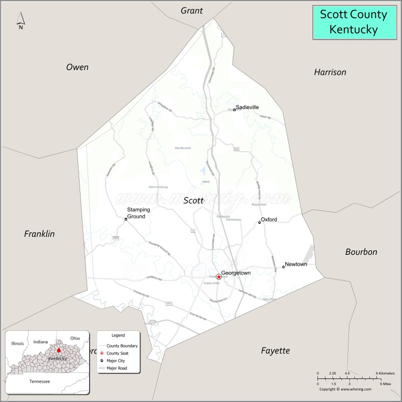
About Scott County Map, Kentucky: The map showing the county boundary, county seat, major cities, highways, water bodies and neighbouring counties.
More Kentucky Maps & Info
Map of Scott County, Kentucky
Scott County is a county located in the U.S. state of Kentucky. It's county seat is Georgetown. As per 2020 census, the population of Scott County is 58252 people and population density is square miles. According to the United States Census Bureau, the county has a total area of 285 sq mi (738 km2). Scott County was established on 1792.
Scott County Facts
| Continent | North America |
| Country | United States |
| State | Kentucky |
| County Seat | Georgetown |
| Largest City/Town | Georgetown |
| Established | 1792 |
| Total Area | 285 sq mi (738 sq km) |
| Land Area | 282 sq mi (730 sq km) |
| Water Area | 3.7 sq mi (10 sq km) |
| Population | 57,155 (Census 2020) |
| Population Density | 203 people per sq mi |
| Time Zone | Eastern Time Zone (ET) |
| Major Highways | Interstate 75, U.S. Route 25, U.S. Route 62, Kentucky Route 32 |
| Major Rivers | Elkhorn Creek |
| Neighboring Counties | Grant County, Harrison County, Bourbon County, Fayette County, Franklin County, Woodford County, Owen County |
| Famous For | Toyota Motor Manufacturing Kentucky, horse farms, Georgetown College, and Bluegrass scenery |
| Top Attractions | Kentucky Horse Park nearby area, Toyota Visitor Center, Yuko-En on the Elkhorn, Georgetown Historic District, Evans Orchard |
| Official Website | Official Website |
About Scott County, Kentucky
Scott County is located in central Kentucky within the Bluegrass region and was established in 1792 as one of Kentucky’s original counties. The county seat and largest city is Georgetown. Scott County is known for world-famous horse farms, automotive manufacturing led by Toyota Motor Manufacturing Kentucky, scenic Bluegrass countryside, historic downtown districts, and strong economic growth connected to the Lexington metropolitan area. ([en.wikipedia.org](https://en.wikipedia.org/wiki/Scott_County%2C_Kentucky?utm_source=chatgpt.com))
Cities and Communities in Scott County, Kentucky
| City/Town | Population | Latitude & Longitude |
|---|---|---|
| Georgetown (county seat) | 37,000+ | 38.2098°N, 84.5588°W |
| Stamping Ground | 900+ | 38.2723°N, 84.6866°W |
| Sadieville | 300+ | 38.3892°N, 84.5324°W |
| Great Crossing | Historic Community | 38.2354°N, 84.5615°W |
| Longlick | Rural Community | 38.1635°N, 84.5129°W |
| Delaplain | Bluegrass Area | 38.2526°N, 84.4698°W |
| Midway Nearby Area | Regional Community | 38.1506°N, 84.6805°W |
| Newtown Pike Area | Commercial Corridor | 38.1882°N, 84.5753°W |
Best Golf Courses in Scott County, Kentucky
| Golf Course | Location | Latitude & Longitude |
|---|---|---|
| Cherry Blossom Golf Club | Georgetown | 38.2248°N, 84.5584°W |
| Canewood Golf Course | Georgetown | 38.1987°N, 84.5938°W |
| Houston Oaks Golf Course | Nearby Paris | 38.2096°N, 84.2413°W |
| Kearney Hill Golf Links | Nearby Lexington | 38.0869°N, 84.5448°W |
What are Major Roads and Highways in Scott County
Major highways connect Scott County with Lexington, Cincinnati, Louisville, and important Bluegrass economic corridors.
- Interstate 75 - major north-south interstate through Georgetown and central Kentucky
- U.S. Route 25 - historic regional highway serving Georgetown and nearby communities
- U.S. Route 62 - important east-west roadway through Bluegrass farmland
- Kentucky Route 32 - scenic connector route serving rural and suburban areas
Neighboring Counties of Scott County
- Grant County (north)
- Harrison County (northeast)
- Bourbon County (east)
- Fayette County (south)
- Franklin County (west)
- Woodford County (southwest)
- Owen County (northwest)
What are Top Attractions in Scott County, Kentucky
The county offers horse-country attractions, parks, historic sites, gardens, and family-friendly Bluegrass tourism destinations.
| Main Sight Name | City | Famous For |
|---|---|---|
| Kentucky Horse Park Nearby Area | Regional Area | Equestrian events, horse museums, and Kentucky horse culture |
| Toyota Visitor Center | Georgetown | Automotive manufacturing tours and exhibits |
| Yuko-En on the Elkhorn | Georgetown | Japanese friendship garden and scenic landscapes |
| Georgetown Historic District | Georgetown | Historic architecture, shops, and restaurants |
| Evans Orchard | Georgetown | Family farm activities, seasonal events, and orchards |
| Georgetown College | Georgetown | Historic liberal arts campus and cultural events |
| Old Friends Thoroughbred Retirement Farm | Georgetown Area | Retired racehorses and equestrian heritage |
| Elkhorn Creek Recreation Areas | Countywide | Kayaking, fishing, and outdoor recreation |
| Bluegrass Horse Farms | Countywide | Scenic countryside and horse breeding operations |
| Community Festivals and Events | Countywide | Local traditions, arts, and seasonal entertainment |
Distance from Scott County to Nearby Cities
The following distances are measured by road (driving).
- Georgetown to Lexington, Kentucky - 16 mi (26 km)
- Georgetown to Frankfort, Kentucky - 27 mi (43 km)
- Georgetown to Louisville, Kentucky - 69 mi (111 km)
- Georgetown to Cincinnati, Ohio - 83 mi (134 km)
- Georgetown to Bowling Green, Kentucky - 137 mi (220 km)
- Georgetown to Columbus, Ohio - 184 mi (296 km)
- Georgetown to Indianapolis, Indiana - 185 mi (298 km)
- Georgetown to Knoxville, Tennessee - 193 mi (311 km)
- Georgetown to Nashville, Tennessee - 223 mi (359 km)
- Georgetown to Charleston, West Virginia - 205 mi (330 km)
- Georgetown to Chicago, Illinois - 316 mi (509 km)
- Georgetown to Atlanta, Georgia - 336 mi (541 km)
References
- Scott County Official Website
- Scott County, Kentucky - Wikipedia
- U.S. Census Bureau QuickFacts
- Visit Scott County Kentucky
- City of Georgetown
- Adair County Map
- Allen County Map
- Anderson County Map
- Ballard County Map
- Barren County Map
- Bath County Map
- Bell County Map
- Boone County Map
- Bourbon County Map
- Boyd County Map
- Boyle County Map
- Bracken County Map
- Breathitt County Map
- Breckinridge County Map
- Bullitt County Map
- Butler County Map
- Caldwell County Map
- Calloway County Map
- Campbell County Map
- Carlisle County Map
- Carroll County Map
- Carter County Map
- Casey County Map
- Christian County Map
- Clark County Map
- Clay County Map
- Clinton County Map
- Crittenden County Map
- Cumberland County Map
- Daviess County Map
- Edmonson County Map
- Elliott County Map
- Estill County Map
- Fayette County Map
- Fleming County Map
- Floyd County Map
- Franklin County Map
- Fulton County Map
- Gallatin County Map
- Garrard County Map
- Grant County Map
- Graves County Map
- Grayson County Map
- Green County Map
- Greenup County Map
- Hancock County Map
- Hardin County Map
- Harlan County Map
- Harrison County Map
- Hart County Map
- Henderson County Map
- Henry County Map
- Hickman County Map
- Hopkins County Map
- Jackson County Map
- Jefferson County Map
- Jessamine County Map
- Johnson County Map
- Kenton County Map
- Knott County Map
- Knox County Map
- LaRue County Map
- Laurel County Map
- Lawrence County Map
- Lee County Map
- Leslie County Map
- Letcher County Map
- Lewis County Map
- Lincoln County Map
- Livingston County Map
- Logan County Map
- Lyon County Map
- McCracken County Map
- McCreary County Map
- McLean County Map
- Madison County Map
- Magoffin County Map
- Marion County Map
- Marshall County Map
- Martin County Map
- Mason County Map
- Meade County Map
- Menifee County Map
- Mercer County Map
- Metcalfe County Map
- Monroe County Map
- Montgomery County Map
- Morgan County Map
- Muhlenberg County Map
- Nelson County Map
- Nicholas County Map
- Ohio County Map
- Oldham County Map
- Owen County Map
- Owsley County Map
- Pendleton County Map
- Perry County Map
- Pike County Map
- Powell County Map
- Pulaski County Map
- Robertson County Map
- Rockcastle County Map
- Rowan County Map
- Russell County Map
- Scott County Map
- Shelby County Map
- Simpson County Map
- Spencer County Map
- Taylor County Map
- Todd County Map
- Trigg County Map
- Trimble County Map
- Union County Map
- Warren County Map
- Washington County Map
- Wayne County Map
- Webster County Map
- Whitley County Map
- Wolfe County Map
- Woodford County Map
- Alabama Counties
- Alaska boroughs
- Arizona Counties
- Arkansas Counties
- California County Map
- Colorado Counties
- Connecticut Counties
- Delaware Counties
- Florida County Map
- Georgia County Map
- Hawaii Counties
- Idaho Counties
- Illinois Counties
- Indiana Counties
- Iowa Counties
- Kansas Counties
- Kentucky Counties
- Louisiana Counties
- Maine Counties
- Maryland Counties
- Massachusetts Counties
- Michigan County Map
- Minnesota Counties
- Mississippi Counties
- Missouri Counties
- Montana Counties
- Nebraska Counties
- Nevada Counties
- New York Counties
- New Hampshire Counties
- New Jersey Counties
- New Mexico Counties
- North Carolina Counties
- North Dakota Counties
- Ohio County Map
- Oklahoma Counties
- Oregon Counties
- Pennsylvania Counties
- Rhode Island Counties
- South Carolina Counties
- South Dakota Counties
- Map of Tennessee
- Texas County Map
- Utah Counties
- Vermont Counties
- Virginia Counties
- Washington Counties
- West Virginia Counties
- Wisconsin Counties
- Wyoming Counties