Map of Logan County - Logan County is a county located in the U.S. state of Kentucky. Logan County Map showing cities, highways, important places and water bodies. Get Where is Logan County located in the map, major cities in Logan county, population, areas, and places of interest.
Map of Logan County, Kentucky
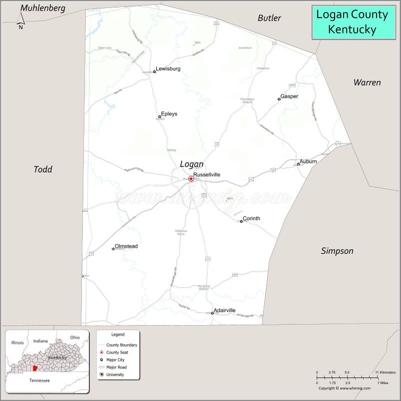
About Logan County Map, Kentucky: The map showing the county boundary, county seat, major cities, highways, water bodies and neighbouring counties.
More Kentucky Maps & Info
Map of Logan County, Kentucky
Logan County is a county located in the U.S. state of Kentucky. It's county seat is Russellville. As per 2020 census, the population of Logan County is 27771 people and population density is square miles. According to the United States Census Bureau, the county has a total area of 556 sq mi (1,440 km2). Logan County was established on 1792.
Logan County Facts
| Continent | North America |
| Country | United States |
| State | Kentucky |
| County Seat | Russellville |
| Largest City/Town | Russellville |
| Established | 1792 |
| Total Area | 557 sq mi (1,443 sq km) |
| Land Area | 552 sq mi (1,430 sq km) |
| Water Area | 5.3 sq mi (14 sq km) |
| Population | 27,432 (Census 2020) |
| Population Density | 50 people per sq mi |
| Time Zone | Central Time Zone (CT) |
| Major Highways | U.S. Route 68, U.S. Route 79, Kentucky Route 80, Kentucky Route 100 |
| Major Rivers | Red River |
| Neighboring Counties | Todd County, Simpson County, Butler County, Warren County, Muhlenberg County, Christian County |
| Famous For | Agriculture, tobacco history, historic Russellville, and western Kentucky heritage |
| Top Attractions | Shaker Museum at South Union, Russellville Historic District, Lake Malone nearby area, Logan County Courthouse, Red River recreation |
| Official Website | Official Website |
About Logan County, Kentucky
Logan County is located in south-central Kentucky near the Tennessee border and was established in 1792. The county seat and largest city is Russellville. Logan County is known for its agricultural traditions, historic communities, tobacco heritage, and preserved Shaker history at South Union. ([en.wikipedia.org](https://en.wikipedia.org/wiki/Logan_County%2C_Kentucky?utm_source=chatgpt.com))
Cities and Communities in Logan County, Kentucky
| City/Town | Population | Latitude & Longitude |
|---|---|---|
| Russellville (county seat) | 7,000+ | 36.8453°N, 86.8872°W |
| Auburn | 1,300+ | 36.8645°N, 86.7103°W |
| Adairville | 900+ | 36.6676°N, 86.8483°W |
| Lewisburg | 800+ | 36.9862°N, 86.9472°W |
| Olmstead | 150+ | 36.7481°N, 86.7300°W |
| Chandlers | Rural Community | 36.9035°N, 86.9431°W |
| South Union | Historic Community | 36.8804°N, 86.9594°W |
| Kirkmansville | Unincorporated | 36.7952°N, 87.0248°W |
Best Golf Courses in Logan County, Kentucky
| Golf Course | Location | Latitude & Longitude |
|---|---|---|
| Russellville Country Club | Russellville | 36.8569°N, 86.8898°W |
| Logan County Golf Course | Auburn Area | 36.8680°N, 86.7137°W |
| CrossWinds Golf Course | Nearby Bowling Green | 36.9425°N, 86.4562°W |
| Kenny Perry's Country Creek Golf Course | Nearby Franklin | 36.7278°N, 86.5885°W |
What are Major Roads and Highways in Logan County
Major highways connect Logan County with Bowling Green, western Kentucky, and nearby Tennessee communities.
- U.S. Route 68 - important east-west highway through Russellville and Auburn
- U.S. Route 79 - major regional corridor linking western Kentucky communities
- Kentucky Route 80 - scenic roadway serving southern Kentucky regions
- Kentucky Route 100 - connector highway through rural farmland communities
Neighboring Counties of Logan County
- Todd County (west)
- Simpson County (east)
- Butler County (north)
- Warren County (northeast)
- Muhlenberg County (northwest)
- Christian County (west)
What are Top Attractions in Logan County, Kentucky
The county offers historic sites, museums, agricultural scenery, and outdoor recreation opportunities.
| Main Sight Name | City | Famous For |
|---|---|---|
| Shaker Museum at South Union | South Union | Historic Shaker village and cultural exhibits |
| Russellville Historic District | Russellville | Historic architecture and downtown heritage |
| Lake Malone Nearby Area | Regional Area | Boating, fishing, and outdoor recreation |
| Logan County Courthouse | Russellville | Historic civic landmark and architecture |
| Red River Recreation | Countywide | Fishing and riverside scenery |
| South Union Shaker Village | South Union | Historic preservation and pioneer history |
| Auburn Historic Area | Auburn | Small-town Kentucky heritage |
| Rural Scenic Drives | Countywide | Rolling farmland and countryside photography |
| Community Festivals | Russellville Area | Seasonal events and local traditions |
| Historic Main Street Russellville | Russellville | Shopping, dining, and local culture |
Distance from Logan County to Nearby Cities
The following distances are measured by road (driving).
- Russellville to Bowling Green, Kentucky - 28 mi (45 km)
- Russellville to Franklin, Kentucky - 24 mi (39 km)
- Russellville to Nashville, Tennessee - 68 mi (109 km)
- Russellville to Owensboro, Kentucky - 86 mi (138 km)
- Russellville to Louisville, Kentucky - 173 mi (278 km)
- Russellville to Clarksville, Tennessee - 52 mi (84 km)
- Russellville to Lexington, Kentucky - 181 mi (291 km)
- Russellville to Memphis, Tennessee - 221 mi (356 km)
- Russellville to Cincinnati, Ohio - 253 mi (407 km)
- Russellville to Indianapolis, Indiana - 255 mi (410 km)
- Russellville to St. Louis, Missouri - 276 mi (444 km)
- Russellville to Atlanta, Georgia - 286 mi (460 km)