Map of Clay County - Clay County is a county located in the U.S. state of Kentucky. Clay County Map showing cities, highways, important places and water bodies. Get Where is Clay County located in the map, major cities in Clay county, population, areas, and places of interest.
Map of Clay County, Kentucky
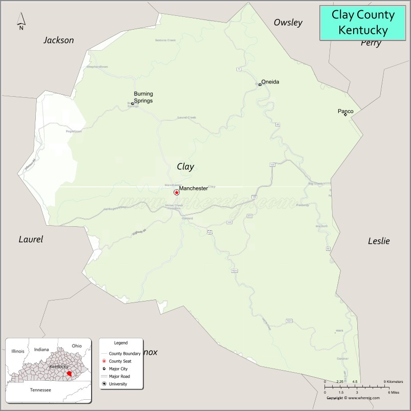
About Clay County Map, Kentucky: The map showing the county boundary, county seat, major cities, highways, water bodies and neighbouring counties.
More Kentucky Maps & Info
Map of Clay County, Kentucky
Clay County is a county located in the U.S. state of Kentucky. It's county seat is Manchester. As per 2020 census, the population of Clay County is 20206 people and population density is square miles. According to the United States Census Bureau, the county has a total area of 471 sq mi (1,220 km2). Clay County was established on 1807.
Clay County Facts
| Continent | North America |
| Country | United States |
| State | Kentucky |
| County Seat | Manchester |
| Largest City/Town | Manchester |
| Established | 1807 |
| Total Area | 471 sq mi (1,220 sq km) |
| Land Area | 470 sq mi (1,217 sq km) |
| Water Area | 1.5 sq mi (4 sq km) |
| Population | 20,345 (Census 2020) |
| Population Density | 43 people per sq mi |
| Time Zone | Eastern Time Zone (ET) |
| Major Highways | Hal Rogers Parkway, Kentucky Route 80, Kentucky Route 11, U.S. Route 421 |
| Major Rivers | South Fork Kentucky River, Goose Creek, Red Bird River |
| Neighboring Counties | Laurel County, Leslie County, Owsley County, Knox County, Perry County, Jackson County |
| Famous For | Appalachian culture, Daniel Boone National Forest, mountain scenery, and outdoor recreation |
| Top Attractions | Redbird Crest Trail, Oneida Baptist Institute, Daniel Boone National Forest, Goose Creek Salt Works, Manchester Historic District |
| Official Website | Official Website |
About Clay County, Kentucky
Clay County is located in southeastern Kentucky within the Appalachian Mountains and was established in 1807. The county seat and largest city is Manchester. Clay County is known for its mountain landscapes, Appalachian heritage, forest recreation, and historic communities surrounded by the Daniel Boone National Forest. ([en.wikipedia.org](https://en.wikipedia.org/wiki/Clay_County%2C_Kentucky?utm_source=chatgpt.com))
Cities and Communities in Clay County, Kentucky
| City/Town | Population | Latitude & Longitude |
|---|---|---|
| Manchester (county seat) | 1,200+ | 37.1537°N, 83.7616°W |
| Oneida | Unincorporated | 37.2656°N, 83.6468°W |
| Big Creek | Unincorporated | 37.2918°N, 83.7397°W |
| Goose Rock | Unincorporated | 37.2154°N, 83.7090°W |
| Red Bird | Historic Community | 37.2150°N, 83.5918°W |
| Burning Springs | Unincorporated | 37.0562°N, 83.8160°W |
| Hacker | Unincorporated | 37.2135°N, 83.8308°W |
| Paces Creek | Unincorporated | 37.0801°N, 83.7021°W |
Best Golf Courses in Clay County, Kentucky
| Golf Course | Location | Latitude & Longitude |
|---|---|---|
| London Country Club | Nearby London | 37.1126°N, 84.0608°W |
| Crooked Creek Golf Club | Nearby London | 37.1471°N, 84.0644°W |
| Sleepy Hollow Golf Course | Nearby Cumberland | 36.9784°N, 82.9893°W |
| Harlan Country Club | Nearby Harlan | 36.8441°N, 83.3337°W |
What are Major Roads and Highways in Clay County
Major highways connect Clay County with Appalachian communities and regional cities in southeastern Kentucky.
- Hal Rogers Parkway - major east-west highway serving Manchester and eastern Kentucky
- Kentucky Route 80 - regional highway through mountain communities and forest areas
- Kentucky Route 11 - important north-south connector through Clay County
- U.S. Route 421 - scenic route linking Manchester with nearby Appalachian regions
Neighboring Counties of Clay County
- Laurel County (west)
- Leslie County (east)
- Owsley County (north)
- Knox County (south)
- Perry County (northeast)
- Jackson County (northwest)
What are Top Attractions in Clay County, Kentucky
The county offers Appalachian scenery, hiking trails, forests, and cultural heritage attractions.
| Main Sight Name | City | Famous For |
|---|---|---|
| Redbird Crest Trail | Red Bird Area | ATV trails and mountain recreation |
| Oneida Baptist Institute | Oneida | Historic Appalachian boarding school |
| Daniel Boone National Forest | Countywide | Camping, hiking, and wilderness scenery |
| Goose Creek Salt Works | Manchester Area | Historic frontier salt production site |
| Manchester Historic District | Manchester | Historic downtown and local shops |
| South Fork Kentucky River | Countywide | Fishing and scenic river landscapes |
| Big Double Creek Arch Nearby Area | Forest Region | Natural rock arch and hiking trails |
| Clay County Historical Museum | Manchester | Local Appalachian history exhibits |
| Mountain Scenic Drives | Countywide | Rolling Appalachian hills and overlooks |
| Red Bird Mission Area | Beverly Area | Community outreach and regional heritage |
Distance from Clay County to Nearby Cities
The following distances are measured by road (driving).
- Manchester to London, Kentucky - 28 mi (45 km)
- Manchester to Hazard, Kentucky - 42 mi (68 km)
- Manchester to Corbin, Kentucky - 39 mi (63 km)
- Manchester to Lexington, Kentucky - 117 mi (188 km)
- Manchester to Somerset, Kentucky - 77 mi (124 km)
- Manchester to Pikeville, Kentucky - 101 mi (163 km)
- Manchester to Knoxville, Tennessee - 117 mi (188 km)
- Manchester to Louisville, Kentucky - 177 mi (285 km)
- Manchester to Charleston, West Virginia - 178 mi (286 km)
- Manchester to Nashville, Tennessee - 213 mi (343 km)
- Manchester to Cincinnati, Ohio - 180 mi (290 km)
- Manchester to Chattanooga, Tennessee - 179 mi (288 km)
References
- Clay County Official Website
- Clay County, Kentucky - Wikipedia
- U.S. Census Bureau QuickFacts
- Daniel Boone National Forest
- Kentucky Atlas and Gazetteer
- Adair County Map
- Allen County Map
- Anderson County Map
- Ballard County Map
- Barren County Map
- Bath County Map
- Bell County Map
- Boone County Map
- Bourbon County Map
- Boyd County Map
- Boyle County Map
- Bracken County Map
- Breathitt County Map
- Breckinridge County Map
- Bullitt County Map
- Butler County Map
- Caldwell County Map
- Calloway County Map
- Campbell County Map
- Carlisle County Map
- Carroll County Map
- Carter County Map
- Casey County Map
- Christian County Map
- Clark County Map
- Clay County Map
- Clinton County Map
- Crittenden County Map
- Cumberland County Map
- Daviess County Map
- Edmonson County Map
- Elliott County Map
- Estill County Map
- Fayette County Map
- Fleming County Map
- Floyd County Map
- Franklin County Map
- Fulton County Map
- Gallatin County Map
- Garrard County Map
- Grant County Map
- Graves County Map
- Grayson County Map
- Green County Map
- Greenup County Map
- Hancock County Map
- Hardin County Map
- Harlan County Map
- Harrison County Map
- Hart County Map
- Henderson County Map
- Henry County Map
- Hickman County Map
- Hopkins County Map
- Jackson County Map
- Jefferson County Map
- Jessamine County Map
- Johnson County Map
- Kenton County Map
- Knott County Map
- Knox County Map
- LaRue County Map
- Laurel County Map
- Lawrence County Map
- Lee County Map
- Leslie County Map
- Letcher County Map
- Lewis County Map
- Lincoln County Map
- Livingston County Map
- Logan County Map
- Lyon County Map
- McCracken County Map
- McCreary County Map
- McLean County Map
- Madison County Map
- Magoffin County Map
- Marion County Map
- Marshall County Map
- Martin County Map
- Mason County Map
- Meade County Map
- Menifee County Map
- Mercer County Map
- Metcalfe County Map
- Monroe County Map
- Montgomery County Map
- Morgan County Map
- Muhlenberg County Map
- Nelson County Map
- Nicholas County Map
- Ohio County Map
- Oldham County Map
- Owen County Map
- Owsley County Map
- Pendleton County Map
- Perry County Map
- Pike County Map
- Powell County Map
- Pulaski County Map
- Robertson County Map
- Rockcastle County Map
- Rowan County Map
- Russell County Map
- Scott County Map
- Shelby County Map
- Simpson County Map
- Spencer County Map
- Taylor County Map
- Todd County Map
- Trigg County Map
- Trimble County Map
- Union County Map
- Warren County Map
- Washington County Map
- Wayne County Map
- Webster County Map
- Whitley County Map
- Wolfe County Map
- Woodford County Map
- Alabama Counties
- Alaska boroughs
- Arizona Counties
- Arkansas Counties
- California County Map
- Colorado Counties
- Connecticut Counties
- Delaware Counties
- Florida County Map
- Georgia County Map
- Hawaii Counties
- Idaho Counties
- Illinois Counties
- Indiana Counties
- Iowa Counties
- Kansas Counties
- Kentucky Counties
- Louisiana Counties
- Maine Counties
- Maryland Counties
- Massachusetts Counties
- Michigan County Map
- Minnesota Counties
- Mississippi Counties
- Missouri Counties
- Montana Counties
- Nebraska Counties
- Nevada Counties
- New York Counties
- New Hampshire Counties
- New Jersey Counties
- New Mexico Counties
- North Carolina Counties
- North Dakota Counties
- Ohio County Map
- Oklahoma Counties
- Oregon Counties
- Pennsylvania Counties
- Rhode Island Counties
- South Carolina Counties
- South Dakota Counties
- Map of Tennessee
- Texas County Map
- Utah Counties
- Vermont Counties
- Virginia Counties
- Washington Counties
- West Virginia Counties
- Wisconsin Counties
- Wyoming Counties