Map of Laurel County - Laurel County is a county located in the U.S. state of Kentucky. Laurel County Map showing cities, highways, important places and water bodies. Get Where is Laurel County located in the map, major cities in Laurel county, population, areas, and places of interest.
Map of Laurel County, Kentucky
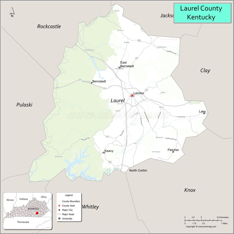
About Laurel County Map, Kentucky: The map showing the county boundary, county seat, major cities, highways, water bodies and neighbouring counties.
More Kentucky Maps & Info
Map of Laurel County, Kentucky
Laurel County is a county located in the U.S. state of Kentucky. It's county seat is London. As per 2020 census, the population of Laurel County is 62561 people and population density is square miles. According to the United States Census Bureau, the county has a total area of 436 sq mi (1,129 km2). Laurel County was established on 1825.
Laurel County Facts
| Continent | North America |
| Country | United States |
| State | Kentucky |
| County Seat | London |
| Largest City/Town | London |
| Established | 1825 |
| Total Area | 444 sq mi (1,150 sq km) |
| Land Area | 434 sq mi (1,124 sq km) |
| Water Area | 9.7 sq mi (25 sq km) |
| Population | 62,613 (Census 2020) |
| Population Density | 144 people per sq mi |
| Time Zone | Eastern Time Zone (ET) |
| Major Highways | Interstate 75, U.S. Route 25, Hal Rogers Parkway, Kentucky Route 80 |
| Major Rivers | Laurel River, Rockcastle River |
| Neighboring Counties | Whitley County, Knox County, Clay County, Jackson County, Rockcastle County, Pulaski County, McCreary County |
| Famous For | World Chicken Festival, Daniel Boone National Forest, outdoor recreation, and Appalachian heritage |
| Top Attractions | Levi Jackson Wilderness Road State Park, Laurel River Lake, Daniel Boone National Forest, World Chicken Festival, London Downtown District |
| Official Website | Official Website |
About Laurel County, Kentucky
Laurel County is located in southeastern Kentucky and was established in 1825 from parts of Rockcastle, Clay, Knox, and Whitley counties. The county seat and largest city is London. Laurel County is known for its Appalachian scenery, outdoor recreation areas, Daniel Boone National Forest access, and the annual World Chicken Festival celebrating the legacy of Colonel Harland Sanders. :contentReference[oaicite:0]{index=0}
Cities and Communities in Laurel County, Kentucky
| City/Town | Population | Latitude & Longitude |
|---|---|---|
| London (county seat) | 8,000+ | 37.1289°N, 84.0833°W |
| Corbin Nearby Area | 18,000+ | 36.9487°N, 84.0969°W |
| East Bernstadt | 800+ | 37.1837°N, 84.1177°W |
| Keavy | Unincorporated | 37.0418°N, 84.1294°W |
| Lily | Rural Community | 37.0106°N, 84.0875°W |
| Pittsburg | Historic Community | 37.1662°N, 84.1099°W |
| Bush | Unincorporated | 37.0991°N, 84.1256°W |
| North Corbin | Regional Community | 36.9807°N, 84.0948°W |
Best Golf Courses in Laurel County, Kentucky
| Golf Course | Location | Latitude & Longitude |
|---|---|---|
| London Country Club | London | 37.1234°N, 84.0681°W |
| Crooked Creek Golf Club | London Area | 37.0985°N, 84.1142°W |
| Holly Bay Golf Course | Laurel River Lake Area | 37.1128°N, 84.2316°W |
| Wasioto Winds Golf Course | Nearby Pineville | 36.7447°N, 83.6948°W |
What are Major Roads and Highways in Laurel County
Major highways connect Laurel County with Lexington, Knoxville, and southeastern Kentucky Appalachian communities.
- Interstate 75 - major north-south interstate corridor through London
- U.S. Route 25 - historic highway serving local communities and businesses
- Hal Rogers Parkway - important east-west transportation route across eastern Kentucky
- Kentucky Route 80 - regional connector roadway through Appalachian foothill areas
Neighboring Counties of Laurel County
- Whitley County (south)
- Knox County (southeast)
- Clay County (east)
- Jackson County (north)
- Rockcastle County (northwest)
- Pulaski County (west)
- McCreary County (southwest)
What are Top Attractions in Laurel County, Kentucky
The county offers forest recreation, hiking trails, lakeside attractions, festivals, and Appalachian cultural landmarks.
| Main Sight Name | City | Famous For |
|---|---|---|
| Levi Jackson Wilderness Road State Park | London | Historic pioneer exhibits and outdoor recreation |
| Laurel River Lake | Laurel County Area | Boating, fishing, and camping |
| Daniel Boone National Forest | Countywide | Hiking, waterfalls, and scenic mountain landscapes |
| World Chicken Festival | London | Annual festival celebrating Colonel Sanders heritage |
| London Downtown District | London | Local shops, restaurants, and historic architecture |
| Camp Wildcat Battlefield | Wildcat Mountain Area | Civil War history and scenic overlooks |
| Holly Bay Marina | Laurel River Lake | Water recreation and lake access |
| Colonel Sanders Café Nearby Area | Corbin Area | Historic Kentucky Fried Chicken heritage site |
| Mountain Life Museum | London | Regional Appalachian history and artifacts |
| Scenic Appalachian Drives | Countywide | Mountain views and countryside photography |
Distance from Laurel County to Nearby Cities
The following distances are measured by road (driving).
- London to Lexington, Kentucky - 76 mi (122 km)
- London to Knoxville, Tennessee - 100 mi (161 km)
- London to Louisville, Kentucky - 166 mi (267 km)
- London to Cincinnati, Ohio - 177 mi (285 km)
- London to Nashville, Tennessee - 190 mi (306 km)
- London to Charleston, West Virginia - 174 mi (280 km)
- London to Indianapolis, Indiana - 255 mi (410 km)
- London to Columbus, Ohio - 236 mi (380 km)
- London to Atlanta, Georgia - 257 mi (414 km)
- London to St. Louis, Missouri - 379 mi (610 km)
- London to Chicago, Illinois - 387 mi (623 km)
- London to Birmingham, Alabama - 301 mi (484 km)
References
- City of London Official Website
- Laurel County, Kentucky - Wikipedia
- U.S. Census Bureau QuickFacts
- Levi Jackson Wilderness Road State Park
- Daniel Boone National Forest
- Adair County Map
- Allen County Map
- Anderson County Map
- Ballard County Map
- Barren County Map
- Bath County Map
- Bell County Map
- Boone County Map
- Bourbon County Map
- Boyd County Map
- Boyle County Map
- Bracken County Map
- Breathitt County Map
- Breckinridge County Map
- Bullitt County Map
- Butler County Map
- Caldwell County Map
- Calloway County Map
- Campbell County Map
- Carlisle County Map
- Carroll County Map
- Carter County Map
- Casey County Map
- Christian County Map
- Clark County Map
- Clay County Map
- Clinton County Map
- Crittenden County Map
- Cumberland County Map
- Daviess County Map
- Edmonson County Map
- Elliott County Map
- Estill County Map
- Fayette County Map
- Fleming County Map
- Floyd County Map
- Franklin County Map
- Fulton County Map
- Gallatin County Map
- Garrard County Map
- Grant County Map
- Graves County Map
- Grayson County Map
- Green County Map
- Greenup County Map
- Hancock County Map
- Hardin County Map
- Harlan County Map
- Harrison County Map
- Hart County Map
- Henderson County Map
- Henry County Map
- Hickman County Map
- Hopkins County Map
- Jackson County Map
- Jefferson County Map
- Jessamine County Map
- Johnson County Map
- Kenton County Map
- Knott County Map
- Knox County Map
- LaRue County Map
- Laurel County Map
- Lawrence County Map
- Lee County Map
- Leslie County Map
- Letcher County Map
- Lewis County Map
- Lincoln County Map
- Livingston County Map
- Logan County Map
- Lyon County Map
- McCracken County Map
- McCreary County Map
- McLean County Map
- Madison County Map
- Magoffin County Map
- Marion County Map
- Marshall County Map
- Martin County Map
- Mason County Map
- Meade County Map
- Menifee County Map
- Mercer County Map
- Metcalfe County Map
- Monroe County Map
- Montgomery County Map
- Morgan County Map
- Muhlenberg County Map
- Nelson County Map
- Nicholas County Map
- Ohio County Map
- Oldham County Map
- Owen County Map
- Owsley County Map
- Pendleton County Map
- Perry County Map
- Pike County Map
- Powell County Map
- Pulaski County Map
- Robertson County Map
- Rockcastle County Map
- Rowan County Map
- Russell County Map
- Scott County Map
- Shelby County Map
- Simpson County Map
- Spencer County Map
- Taylor County Map
- Todd County Map
- Trigg County Map
- Trimble County Map
- Union County Map
- Warren County Map
- Washington County Map
- Wayne County Map
- Webster County Map
- Whitley County Map
- Wolfe County Map
- Woodford County Map
- Alabama Counties
- Alaska boroughs
- Arizona Counties
- Arkansas Counties
- California County Map
- Colorado Counties
- Connecticut Counties
- Delaware Counties
- Florida County Map
- Georgia County Map
- Hawaii Counties
- Idaho Counties
- Illinois Counties
- Indiana Counties
- Iowa Counties
- Kansas Counties
- Kentucky Counties
- Louisiana Counties
- Maine Counties
- Maryland Counties
- Massachusetts Counties
- Michigan County Map
- Minnesota Counties
- Mississippi Counties
- Missouri Counties
- Montana Counties
- Nebraska Counties
- Nevada Counties
- New York Counties
- New Hampshire Counties
- New Jersey Counties
- New Mexico Counties
- North Carolina Counties
- North Dakota Counties
- Ohio County Map
- Oklahoma Counties
- Oregon Counties
- Pennsylvania Counties
- Rhode Island Counties
- South Carolina Counties
- South Dakota Counties
- Map of Tennessee
- Texas County Map
- Utah Counties
- Vermont Counties
- Virginia Counties
- Washington Counties
- West Virginia Counties
- Wisconsin Counties
- Wyoming Counties