Map of Oldham County - Oldham County is a county located in the U.S. state of Kentucky. Oldham County Map showing cities, highways, important places and water bodies. Get Where is Oldham County located in the map, major cities in Oldham county, population, areas, and places of interest.
Map of Oldham County, Kentucky
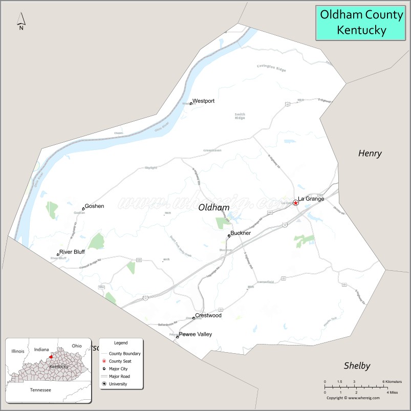
About Oldham County Map, Kentucky: The map showing the county boundary, county seat, major cities, highways, water bodies and neighbouring counties.
More Kentucky Maps & Info
Map of Oldham County, Kentucky
Oldham County is a county located in the U.S. state of Kentucky. It's county seat is La Grange. As per 2020 census, the population of Oldham County is 68685 people and population density is square miles. According to the United States Census Bureau, the county has a total area of 189 sq mi (490 km2). Oldham County was established on 1823.
Oldham County Facts
| Continent | North America |
| Country | United States |
| State | Kentucky |
| County Seat | La Grange |
| Largest City/Town | La Grange |
| Established | 1823 |
| Total Area | 196 sq mi (508 sq km) |
| Land Area | 189 sq mi (490 sq km) |
| Water Area | 6.5 sq mi (17 sq km) |
| Population | 67,607 (Census 2020) |
| Population Density | 358 people per sq mi |
| Time Zone | Eastern Time Zone (ET) |
| Major Highways | Interstate 71, U.S. Route 42, Kentucky Route 53, Kentucky Route 146 |
| Major Rivers | Ohio River |
| Neighboring Counties | Jefferson County, Henry County, Trimble County, Shelby County, Clark County (IN) |
| Famous For | La Grange railroad street, Louisville suburban communities, horse farms, and Ohio River scenery |
| Top Attractions | Main Street La Grange, Yew Dell Botanical Gardens, Creasey Mahan Nature Preserve, Kentucky Artisan Distillery, Ohio River scenic areas |
| Official Website | Official Website |
About Oldham County, Kentucky
Oldham County is located in north-central Kentucky along the Ohio River and was established in 1823. The county seat and largest city is La Grange. Oldham County is known for its scenic horse farms, growing suburban communities near Louisville, historic downtown districts, and the unique railroad tracks running directly through Main Street in La Grange. ([en.wikipedia.org](https://en.wikipedia.org/wiki/Oldham_County%2C_Kentucky?utm_source=chatgpt.com))
Cities and Communities in Oldham County, Kentucky
| City/Town | Population | Latitude & Longitude |
|---|---|---|
| La Grange (county seat) | 10,000+ | 38.4073°N, 85.3780°W |
| Crestwood | 6,000+ | 38.3248°N, 85.4725°W |
| Prospect (partial) | 5,000+ | 38.3617°N, 85.6155°W |
| Buckner | 4,000+ | 38.3720°N, 85.4438°W |
| Pewee Valley | 1,500+ | 38.3040°N, 85.4897°W |
| Goshen | 900+ | 38.4017°N, 85.5775°W |
| Westport | Historic River Community | 38.4817°N, 85.4641°W |
| Orchard Grass Hills | Residential Community | 38.3131°N, 85.4621°W |
Best Golf Courses in Oldham County, Kentucky
| Golf Course | Location | Latitude & Longitude |
|---|---|---|
| Oldham County Country Club | La Grange | 38.4236°N, 85.3769°W |
| Nevel Meade Golf Course | Prospect Area | 38.3845°N, 85.5917°W |
| Harmony Landing Country Club | Goshen | 38.4032°N, 85.5788°W |
| Covered Bridge Golf Club | Nearby Sellersburg, IN | 38.3864°N, 85.7453°W |
What are Major Roads and Highways in Oldham County
Major highways connect Oldham County with Louisville, northern Kentucky, and important Ohio River transportation corridors.
- Interstate 71 - major interstate linking Louisville with Cincinnati and northern Kentucky
- U.S. Route 42 - scenic highway through horse farms and suburban communities
- Kentucky Route 53 - regional connector roadway through La Grange and nearby areas
- Kentucky Route 146 - important route serving residential and commercial growth areas
Neighboring Counties of Oldham County
- Jefferson County (southwest)
- Henry County (east)
- Trimble County (north)
- Shelby County (south)
- Clark County, Indiana (west across the Ohio River)
What are Top Attractions in Oldham County, Kentucky
The county offers botanical gardens, horse-country scenery, historic downtown areas, distilleries, and outdoor recreation destinations.
| Main Sight Name | City | Famous For |
|---|---|---|
| Main Street La Grange | La Grange | Railroad tracks running through downtown streets |
| Yew Dell Botanical Gardens | Crestwood | Gardens, walking trails, and horticultural exhibits |
| Creasey Mahan Nature Preserve | Goshen | Nature trails, wildlife, and environmental education |
| Kentucky Artisan Distillery | Crestwood | Bourbon tours and Kentucky spirits |
| Ohio River Scenic Areas | Westport Area | River overlooks and photography opportunities |
| Historic Downtown La Grange | La Grange | Local shops, restaurants, and historic buildings |
| Open Range Sports | Crestwood | Outdoor recreation and sporting activities |
| Pewee Valley Historic District | Pewee Valley | Historic homes and small-town charm |
| Horse Farm Scenic Drives | Countywide | Bluegrass countryside and equestrian culture |
| Community Festivals and Events | Countywide | Seasonal celebrations and family entertainment |
Distance from Oldham County to Nearby Cities
The following distances are measured by road (driving).
- La Grange to Louisville, Kentucky - 25 mi (40 km)
- La Grange to Frankfort, Kentucky - 42 mi (68 km)
- La Grange to Lexington, Kentucky - 73 mi (117 km)
- La Grange to Cincinnati, Ohio - 82 mi (132 km)
- La Grange to Indianapolis, Indiana - 113 mi (182 km)
- La Grange to Bowling Green, Kentucky - 137 mi (220 km)
- La Grange to Nashville, Tennessee - 197 mi (317 km)
- La Grange to Columbus, Ohio - 202 mi (325 km)
- La Grange to St. Louis, Missouri - 277 mi (446 km)
- La Grange to Knoxville, Tennessee - 260 mi (418 km)
- La Grange to Chicago, Illinois - 311 mi (500 km)
- La Grange to Atlanta, Georgia - 386 mi (621 km)
References
- Oldham County Official Website
- Oldham County, Kentucky - Wikipedia
- U.S. Census Bureau QuickFacts
- Visit Oldham County
- Yew Dell Botanical Gardens
- Adair County Map
- Allen County Map
- Anderson County Map
- Ballard County Map
- Barren County Map
- Bath County Map
- Bell County Map
- Boone County Map
- Bourbon County Map
- Boyd County Map
- Boyle County Map
- Bracken County Map
- Breathitt County Map
- Breckinridge County Map
- Bullitt County Map
- Butler County Map
- Caldwell County Map
- Calloway County Map
- Campbell County Map
- Carlisle County Map
- Carroll County Map
- Carter County Map
- Casey County Map
- Christian County Map
- Clark County Map
- Clay County Map
- Clinton County Map
- Crittenden County Map
- Cumberland County Map
- Daviess County Map
- Edmonson County Map
- Elliott County Map
- Estill County Map
- Fayette County Map
- Fleming County Map
- Floyd County Map
- Franklin County Map
- Fulton County Map
- Gallatin County Map
- Garrard County Map
- Grant County Map
- Graves County Map
- Grayson County Map
- Green County Map
- Greenup County Map
- Hancock County Map
- Hardin County Map
- Harlan County Map
- Harrison County Map
- Hart County Map
- Henderson County Map
- Henry County Map
- Hickman County Map
- Hopkins County Map
- Jackson County Map
- Jefferson County Map
- Jessamine County Map
- Johnson County Map
- Kenton County Map
- Knott County Map
- Knox County Map
- LaRue County Map
- Laurel County Map
- Lawrence County Map
- Lee County Map
- Leslie County Map
- Letcher County Map
- Lewis County Map
- Lincoln County Map
- Livingston County Map
- Logan County Map
- Lyon County Map
- McCracken County Map
- McCreary County Map
- McLean County Map
- Madison County Map
- Magoffin County Map
- Marion County Map
- Marshall County Map
- Martin County Map
- Mason County Map
- Meade County Map
- Menifee County Map
- Mercer County Map
- Metcalfe County Map
- Monroe County Map
- Montgomery County Map
- Morgan County Map
- Muhlenberg County Map
- Nelson County Map
- Nicholas County Map
- Ohio County Map
- Oldham County Map
- Owen County Map
- Owsley County Map
- Pendleton County Map
- Perry County Map
- Pike County Map
- Powell County Map
- Pulaski County Map
- Robertson County Map
- Rockcastle County Map
- Rowan County Map
- Russell County Map
- Scott County Map
- Shelby County Map
- Simpson County Map
- Spencer County Map
- Taylor County Map
- Todd County Map
- Trigg County Map
- Trimble County Map
- Union County Map
- Warren County Map
- Washington County Map
- Wayne County Map
- Webster County Map
- Whitley County Map
- Wolfe County Map
- Woodford County Map
- Alabama Counties
- Alaska boroughs
- Arizona Counties
- Arkansas Counties
- California County Map
- Colorado Counties
- Connecticut Counties
- Delaware Counties
- Florida County Map
- Georgia County Map
- Hawaii Counties
- Idaho Counties
- Illinois Counties
- Indiana Counties
- Iowa Counties
- Kansas Counties
- Kentucky Counties
- Louisiana Counties
- Maine Counties
- Maryland Counties
- Massachusetts Counties
- Michigan County Map
- Minnesota Counties
- Mississippi Counties
- Missouri Counties
- Montana Counties
- Nebraska Counties
- Nevada Counties
- New York Counties
- New Hampshire Counties
- New Jersey Counties
- New Mexico Counties
- North Carolina Counties
- North Dakota Counties
- Ohio County Map
- Oklahoma Counties
- Oregon Counties
- Pennsylvania Counties
- Rhode Island Counties
- South Carolina Counties
- South Dakota Counties
- Map of Tennessee
- Texas County Map
- Utah Counties
- Vermont Counties
- Virginia Counties
- Washington Counties
- West Virginia Counties
- Wisconsin Counties
- Wyoming Counties