Map of Fulton County - Fulton County is a county located in the U.S. state of Kentucky. Fulton County Map showing cities, highways, important places and water bodies. Get Where is Fulton County located in the map, major cities in Fulton county, population, areas, and places of interest.
Map of Fulton County, Kentucky
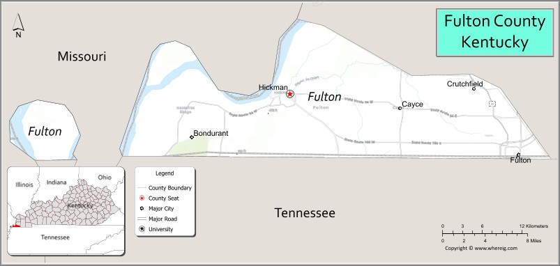
About Fulton County Map, Kentucky: The map showing the county boundary, county seat, major cities, highways, water bodies and neighbouring counties.
More Kentucky Maps & Info
Map of Fulton County, Kentucky
Fulton County is a county located in the U.S. state of Kentucky. It's county seat is Hickman. As per 2020 census, the population of Fulton County is 6512 people and population density is square miles. According to the United States Census Bureau, the county has a total area of 209 sq mi (541 km2). Fulton County was established on 1845.
Fulton County Facts
| Continent | North America |
| Country | United States |
| State | Kentucky |
| County Seat | Hickman |
| Largest City/Town | Fulton |
| Established | 1845 |
| Total Area | 231 sq mi (598 sq km) |
| Land Area | 206 sq mi (534 sq km) |
| Water Area | 25 sq mi (65 sq km) |
| Population | 7,221 (Census 2020) |
| Population Density | 35 people per sq mi |
| Time Zone | Central Time Zone (CT) |
| Major Highways | U.S. Route 51, U.S. Route 45E nearby area, Kentucky Route 94, Interstate 69 nearby area |
| Major Rivers | Mississippi River, Obion Creek |
| Neighboring Counties | Hickman County, Graves County, Obion County (TN), Mississippi County (MO) |
| Famous For | Mississippi River scenery, riverboat history, western Kentucky agriculture, and the Kentucky Bend region |
| Top Attractions | Hickman Riverfront, Kentucky Bend, Columbus-Belmont State Park nearby area, Historic Downtown Hickman, Mississippi River overlooks |
| Official Website | Official Website |
About Fulton County, Kentucky
Fulton County is located in the far western corner of Kentucky along the Mississippi River and was established in 1845. The county seat is Hickman, while Fulton is the largest city. Fulton County is known for its Mississippi River heritage, fertile farmland, river commerce history, and the unique Kentucky Bend geographic area surrounded by the river. ([en.wikipedia.org](https://en.wikipedia.org/wiki/Fulton_County%2C_Kentucky?utm_source=chatgpt.com))
Cities and Communities in Fulton County, Kentucky
| City/Town | Population | Latitude & Longitude |
|---|---|---|
| Fulton | 2,200+ | 36.5045°N, 88.8748°W |
| Hickman (county seat) | 2,000+ | 36.5717°N, 89.1862°W |
| Cayce | Unincorporated | 36.5795°N, 88.9720°W |
| Water Valley | Historic Community | 36.5702°N, 88.8137°W |
| Dorena | Unincorporated | 36.6189°N, 89.0617°W |
| Jordan | Unincorporated | 36.5090°N, 89.0588°W |
| Rush | Historic Community | 36.5413°N, 89.0121°W |
| Bondurant | Unincorporated | 36.6170°N, 88.9598°W |
Best Golf Courses in Fulton County, Kentucky
| Golf Course | Location | Latitude & Longitude |
|---|---|---|
| Fulton Country Club | Fulton | 36.5116°N, 88.8785°W |
| Columbus-Belmont State Park Golf Nearby Area | Regional Area | 36.7614°N, 89.1036°W |
| Mayfield Graves Country Club | Nearby Mayfield | 36.7527°N, 88.6502°W |
| Confederate Ridge Golf Course | Nearby Union City, Tennessee | 36.4198°N, 89.0416°W |
What are Major Roads and Highways in Fulton County
Major highways connect Fulton County with Tennessee, Missouri, and western Kentucky communities.
- U.S. Route 51 - major north-south highway through Fulton and western Kentucky
- U.S. Route 45E nearby area - regional corridor connecting nearby Tennessee and Kentucky areas
- Kentucky Route 94 - important east-west roadway through farming communities
- Interstate 69 nearby area - interstate transportation access serving the Mississippi River region
Neighboring Counties of Fulton County
- Hickman County (north)
- Graves County (east)
- Obion County, Tennessee (south)
- Mississippi County, Missouri (west across the Mississippi River)
What are Top Attractions in Fulton County, Kentucky
The county offers Mississippi River scenery, historic river towns, parks, and outdoor recreation.
| Main Sight Name | City | Famous For |
|---|---|---|
| Hickman Riverfront | Hickman | Mississippi River views and historic riverboat heritage |
| Kentucky Bend | Western County Area | Unique geographic peninsula surrounded by the Mississippi River |
| Columbus-Belmont State Park Nearby Area | Regional Area | Civil War history and river overlooks |
| Historic Downtown Hickman | Hickman | Historic architecture and river commerce heritage |
| Mississippi River Overlooks | Countywide | Scenic photography and river observation |
| Fulton Railroad Heritage | Fulton | Historic railroad connections and transportation history |
| Obion Creek Recreation Area | Countywide | Fishing and nature scenery |
| Riverfront Scenic Drives | Countywide | Views of farmland and the Mississippi River |
| Fulton County Museum Area | Hickman | Local history and cultural exhibits |
| Birdwatching Areas | Countywide | Migratory bird habitats and wildlife viewing |
Distance from Fulton County to Nearby Cities
The following distances are measured by road (driving).
- Hickman to Paducah, Kentucky - 54 mi (87 km)
- Fulton to Union City, Tennessee - 10 mi (16 km)
- Hickman to Cape Girardeau, Missouri - 79 mi (127 km)
- Fulton to Jackson, Tennessee - 72 mi (116 km)
- Hickman to Memphis, Tennessee - 150 mi (241 km)
- Fulton to Nashville, Tennessee - 155 mi (249 km)
- Hickman to Evansville, Indiana - 150 mi (241 km)
- Fulton to St. Louis, Missouri - 194 mi (312 km)
- Hickman to Louisville, Kentucky - 240 mi (386 km)
- Fulton to Lexington, Kentucky - 275 mi (443 km)
- Hickman to Indianapolis, Indiana - 256 mi (412 km)
- Fulton to Little Rock, Arkansas - 247 mi (398 km)
References
- Fulton County Official Website
- Fulton County, Kentucky - Wikipedia
- U.S. Census Bureau QuickFacts
- Columbus-Belmont State Park
- Kentucky Atlas and Gazetteer
- Adair County Map
- Allen County Map
- Anderson County Map
- Ballard County Map
- Barren County Map
- Bath County Map
- Bell County Map
- Boone County Map
- Bourbon County Map
- Boyd County Map
- Boyle County Map
- Bracken County Map
- Breathitt County Map
- Breckinridge County Map
- Bullitt County Map
- Butler County Map
- Caldwell County Map
- Calloway County Map
- Campbell County Map
- Carlisle County Map
- Carroll County Map
- Carter County Map
- Casey County Map
- Christian County Map
- Clark County Map
- Clay County Map
- Clinton County Map
- Crittenden County Map
- Cumberland County Map
- Daviess County Map
- Edmonson County Map
- Elliott County Map
- Estill County Map
- Fayette County Map
- Fleming County Map
- Floyd County Map
- Franklin County Map
- Fulton County Map
- Gallatin County Map
- Garrard County Map
- Grant County Map
- Graves County Map
- Grayson County Map
- Green County Map
- Greenup County Map
- Hancock County Map
- Hardin County Map
- Harlan County Map
- Harrison County Map
- Hart County Map
- Henderson County Map
- Henry County Map
- Hickman County Map
- Hopkins County Map
- Jackson County Map
- Jefferson County Map
- Jessamine County Map
- Johnson County Map
- Kenton County Map
- Knott County Map
- Knox County Map
- LaRue County Map
- Laurel County Map
- Lawrence County Map
- Lee County Map
- Leslie County Map
- Letcher County Map
- Lewis County Map
- Lincoln County Map
- Livingston County Map
- Logan County Map
- Lyon County Map
- McCracken County Map
- McCreary County Map
- McLean County Map
- Madison County Map
- Magoffin County Map
- Marion County Map
- Marshall County Map
- Martin County Map
- Mason County Map
- Meade County Map
- Menifee County Map
- Mercer County Map
- Metcalfe County Map
- Monroe County Map
- Montgomery County Map
- Morgan County Map
- Muhlenberg County Map
- Nelson County Map
- Nicholas County Map
- Ohio County Map
- Oldham County Map
- Owen County Map
- Owsley County Map
- Pendleton County Map
- Perry County Map
- Pike County Map
- Powell County Map
- Pulaski County Map
- Robertson County Map
- Rockcastle County Map
- Rowan County Map
- Russell County Map
- Scott County Map
- Shelby County Map
- Simpson County Map
- Spencer County Map
- Taylor County Map
- Todd County Map
- Trigg County Map
- Trimble County Map
- Union County Map
- Warren County Map
- Washington County Map
- Wayne County Map
- Webster County Map
- Whitley County Map
- Wolfe County Map
- Woodford County Map
- Alabama Counties
- Alaska boroughs
- Arizona Counties
- Arkansas Counties
- California County Map
- Colorado Counties
- Connecticut Counties
- Delaware Counties
- Florida County Map
- Georgia County Map
- Hawaii Counties
- Idaho Counties
- Illinois Counties
- Indiana Counties
- Iowa Counties
- Kansas Counties
- Kentucky Counties
- Louisiana Counties
- Maine Counties
- Maryland Counties
- Massachusetts Counties
- Michigan County Map
- Minnesota Counties
- Mississippi Counties
- Missouri Counties
- Montana Counties
- Nebraska Counties
- Nevada Counties
- New York Counties
- New Hampshire Counties
- New Jersey Counties
- New Mexico Counties
- North Carolina Counties
- North Dakota Counties
- Ohio County Map
- Oklahoma Counties
- Oregon Counties
- Pennsylvania Counties
- Rhode Island Counties
- South Carolina Counties
- South Dakota Counties
- Map of Tennessee
- Texas County Map
- Utah Counties
- Vermont Counties
- Virginia Counties
- Washington Counties
- West Virginia Counties
- Wisconsin Counties
- Wyoming Counties