Map of Shelby County - Shelby County is a county located in the U.S. state of Kentucky. Shelby County Map showing cities, highways, important places and water bodies. Get Where is Shelby County located in the map, major cities in Shelby county, population, areas, and places of interest.
Map of Shelby County, Kentucky
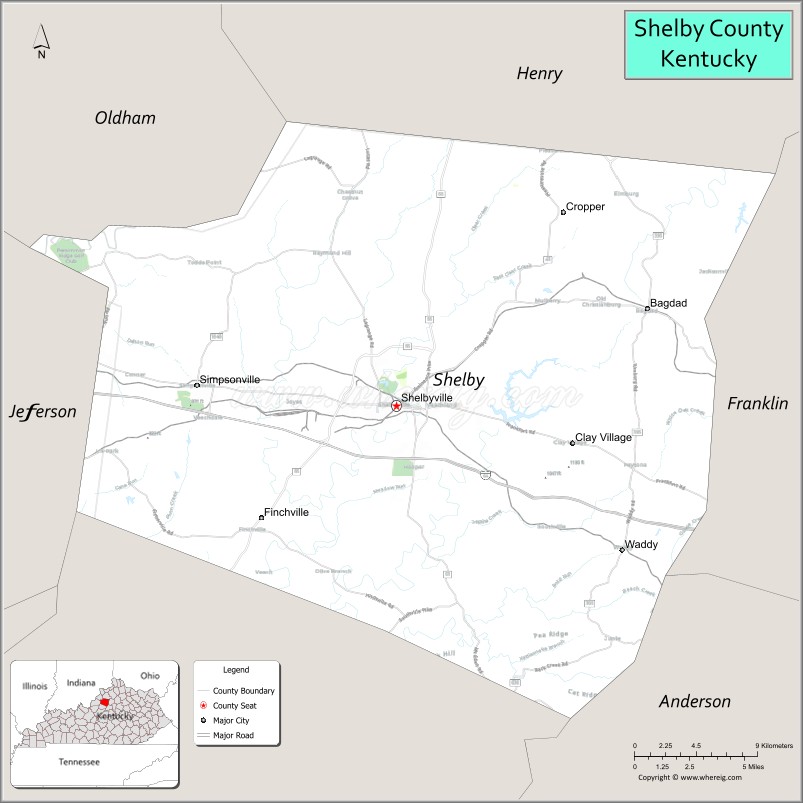
About Shelby County Map, Kentucky: The map showing the county boundary, county seat, major cities, highways, water bodies and neighbouring counties.
More Kentucky Maps & Info
Map of Shelby County, Kentucky
Shelby County is a county located in the U.S. state of Kentucky. It's county seat is Shelbyville. As per 2020 census, the population of Shelby County is 48461 people and population density is square miles. According to the United States Census Bureau, the county has a total area of 384 sq mi (995 km2). Shelby County was established on 1792.
Shelby County Facts
| Continent | North America |
| Country | United States |
| State | Kentucky |
| County Seat | Shelbyville |
| Largest City/Town | Shelbyville |
| Established | 1792 |
| Total Area | 386 sq mi (1,000 sq km) |
| Land Area | 380 sq mi (984 sq km) |
| Water Area | 6.4 sq mi (17 sq km) |
| Population | 48,065 (Census 2020) |
| Population Density | 126 people per sq mi |
| Time Zone | Eastern Time Zone (ET) |
| Major Highways | Interstate 64, U.S. Route 60, Kentucky Route 55, Kentucky Route 53 |
| Major Rivers | Kentucky River tributaries, Guist Creek |
| Neighboring Counties | Franklin County, Henry County, Spencer County, Anderson County, Woodford County, Jefferson County |
| Famous For | American Saddlebred horse farms, Shelbyville horse culture, bourbon region scenery, and Bluegrass agriculture |
| Top Attractions | Jeptha Creed Distillery, Red Orchard Park, Shelby County Community Theatre, Weissinger Hills Golf Course, Guist Creek Lake |
| Official Website | Official Website |
About Shelby County, Kentucky
Shelby County is located in north-central Kentucky within the Bluegrass region and was established in 1792 as one of Kentucky’s original counties. The county seat and largest city is Shelbyville. Shelby County is known as the “American Saddlebred Capital of the World” because of its horse farms, equestrian traditions, scenic countryside, bourbon heritage, and strong agricultural economy near Louisville and Lexington. ([en.wikipedia.org](https://en.wikipedia.org/wiki/Shelby_County%2C_Kentucky?utm_source=chatgpt.com))
Cities and Communities in Shelby County, Kentucky
| City/Town | Population | Latitude & Longitude |
|---|---|---|
| Shelbyville (county seat) | 17,000+ | 38.2120°N, 85.2230°W |
| Simpsonville | 3,000+ | 38.2220°N, 85.3558°W |
| Bagdad | Historic Community | 38.2476°N, 85.0655°W |
| Finchville | Rural Community | 38.1412°N, 85.3902°W |
| Waddy | Small Community | 38.1140°N, 85.1135°W |
| Cropper | Agricultural Community | 38.0837°N, 85.0491°W |
| Clay Village | Residential Area | 38.2788°N, 85.2268°W |
| Southville | Unincorporated | 38.1544°N, 85.2107°W |
Best Golf Courses in Shelby County, Kentucky
| Golf Course | Location | Latitude & Longitude |
|---|---|---|
| Weissinger Hills Golf Course | Shelbyville | 38.2361°N, 85.2114°W |
| Persimmon Ridge Golf Club | Nearby Louisville Area | 38.2584°N, 85.4210°W |
| Shelbyville Country Club | Shelbyville | 38.2087°N, 85.2325°W |
| Valhalla Golf Club | Nearby Louisville Area | 38.2458°N, 85.5145°W |
What are Major Roads and Highways in Shelby County
Major highways connect Shelby County with Louisville, Lexington, and important Bluegrass horse-country regions.
- Interstate 64 - major east-west interstate through Shelbyville and central Kentucky
- U.S. Route 60 - historic regional highway linking communities and commercial areas
- Kentucky Route 55 - important north-south route serving rural and suburban areas
- Kentucky Route 53 - connector roadway through horse farms and countryside
Neighboring Counties of Shelby County
- Franklin County (north)
- Henry County (northeast)
- Spencer County (southwest)
- Anderson County (south)
- Woodford County (east)
- Jefferson County (west)
What are Top Attractions in Shelby County, Kentucky
The county offers horse farms, bourbon attractions, parks, scenic countryside, and family-friendly Bluegrass destinations.
| Main Sight Name | City | Famous For |
|---|---|---|
| Jeptha Creed Distillery | Shelbyville | Craft bourbon and farm-to-bottle whiskey tours |
| Red Orchard Park | Shelbyville | Walking trails, sports facilities, and recreation |
| Shelby County Community Theatre | Shelbyville | Local performing arts and entertainment |
| Weissinger Hills Golf Course | Shelbyville | Championship golf and scenic landscapes |
| Guist Creek Lake | Countywide | Fishing, boating, and outdoor recreation |
| Historic Downtown Shelbyville | Shelbyville | Historic architecture, shops, and restaurants |
| American Saddlebred Horse Farms | Countywide | Equestrian culture and scenic horse-country drives |
| Gallrein Farms | Shelbyville Area | Seasonal farm events and family activities |
| Clear Creek Park | Shelbyville | Outdoor recreation and sports activities |
| Bluegrass Scenic Drives | Countywide | Rolling farmland and Kentucky countryside views |
Distance from Shelby County to Nearby Cities
The following distances are measured by road (driving).
- Shelbyville to Louisville, Kentucky - 30 mi (48 km)
- Shelbyville to Frankfort, Kentucky - 31 mi (50 km)
- Shelbyville to Lexington, Kentucky - 55 mi (89 km)
- Shelbyville to Cincinnati, Ohio - 103 mi (166 km)
- Shelbyville to Bowling Green, Kentucky - 111 mi (179 km)
- Shelbyville to Indianapolis, Indiana - 141 mi (227 km)
- Shelbyville to Nashville, Tennessee - 175 mi (282 km)
- Shelbyville to Columbus, Ohio - 215 mi (346 km)
- Shelbyville to Knoxville, Tennessee - 240 mi (386 km)
- Shelbyville to St. Louis, Missouri - 274 mi (441 km)
- Shelbyville to Chicago, Illinois - 304 mi (489 km)
- Shelbyville to Atlanta, Georgia - 361 mi (581 km)
References
- Shelby County Official Website
- Shelby County, Kentucky - Wikipedia
- U.S. Census Bureau QuickFacts
- Visit ShelbyKY Tourism
- Jeptha Creed Distillery
- Adair County Map
- Allen County Map
- Anderson County Map
- Ballard County Map
- Barren County Map
- Bath County Map
- Bell County Map
- Boone County Map
- Bourbon County Map
- Boyd County Map
- Boyle County Map
- Bracken County Map
- Breathitt County Map
- Breckinridge County Map
- Bullitt County Map
- Butler County Map
- Caldwell County Map
- Calloway County Map
- Campbell County Map
- Carlisle County Map
- Carroll County Map
- Carter County Map
- Casey County Map
- Christian County Map
- Clark County Map
- Clay County Map
- Clinton County Map
- Crittenden County Map
- Cumberland County Map
- Daviess County Map
- Edmonson County Map
- Elliott County Map
- Estill County Map
- Fayette County Map
- Fleming County Map
- Floyd County Map
- Franklin County Map
- Fulton County Map
- Gallatin County Map
- Garrard County Map
- Grant County Map
- Graves County Map
- Grayson County Map
- Green County Map
- Greenup County Map
- Hancock County Map
- Hardin County Map
- Harlan County Map
- Harrison County Map
- Hart County Map
- Henderson County Map
- Henry County Map
- Hickman County Map
- Hopkins County Map
- Jackson County Map
- Jefferson County Map
- Jessamine County Map
- Johnson County Map
- Kenton County Map
- Knott County Map
- Knox County Map
- LaRue County Map
- Laurel County Map
- Lawrence County Map
- Lee County Map
- Leslie County Map
- Letcher County Map
- Lewis County Map
- Lincoln County Map
- Livingston County Map
- Logan County Map
- Lyon County Map
- McCracken County Map
- McCreary County Map
- McLean County Map
- Madison County Map
- Magoffin County Map
- Marion County Map
- Marshall County Map
- Martin County Map
- Mason County Map
- Meade County Map
- Menifee County Map
- Mercer County Map
- Metcalfe County Map
- Monroe County Map
- Montgomery County Map
- Morgan County Map
- Muhlenberg County Map
- Nelson County Map
- Nicholas County Map
- Ohio County Map
- Oldham County Map
- Owen County Map
- Owsley County Map
- Pendleton County Map
- Perry County Map
- Pike County Map
- Powell County Map
- Pulaski County Map
- Robertson County Map
- Rockcastle County Map
- Rowan County Map
- Russell County Map
- Scott County Map
- Shelby County Map
- Simpson County Map
- Spencer County Map
- Taylor County Map
- Todd County Map
- Trigg County Map
- Trimble County Map
- Union County Map
- Warren County Map
- Washington County Map
- Wayne County Map
- Webster County Map
- Whitley County Map
- Wolfe County Map
- Woodford County Map
- Alabama Counties
- Alaska boroughs
- Arizona Counties
- Arkansas Counties
- California County Map
- Colorado Counties
- Connecticut Counties
- Delaware Counties
- Florida County Map
- Georgia County Map
- Hawaii Counties
- Idaho Counties
- Illinois Counties
- Indiana Counties
- Iowa Counties
- Kansas Counties
- Kentucky Counties
- Louisiana Counties
- Maine Counties
- Maryland Counties
- Massachusetts Counties
- Michigan County Map
- Minnesota Counties
- Mississippi Counties
- Missouri Counties
- Montana Counties
- Nebraska Counties
- Nevada Counties
- New York Counties
- New Hampshire Counties
- New Jersey Counties
- New Mexico Counties
- North Carolina Counties
- North Dakota Counties
- Ohio County Map
- Oklahoma Counties
- Oregon Counties
- Pennsylvania Counties
- Rhode Island Counties
- South Carolina Counties
- South Dakota Counties
- Map of Tennessee
- Texas County Map
- Utah Counties
- Vermont Counties
- Virginia Counties
- Washington Counties
- West Virginia Counties
- Wisconsin Counties
- Wyoming Counties