Map of Breckinridge County - Breckinridge County is a county located in the U.S. state of Kentucky. Breckinridge County Map showing cities, highways, important places and water bodies. Get Where is Breckinridge County located in the map, major cities in Breckinridge county, population, areas, and places of interest.
Map of Breckinridge County, Kentucky
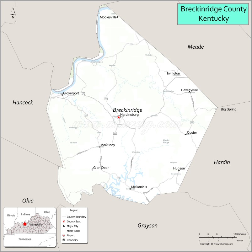
About Breckinridge County Map, Kentucky: The map showing the county boundary, county seat, major cities, highways, water bodies and neighbouring counties.
More Kentucky Maps & Info
Map of Breckinridge County, Kentucky
Breckinridge County is a county located in the U.S. state of Kentucky. It's county seat is Hardinsburg. As per 2020 census, the population of Breckinridge County is 20651 people and population density is square miles. According to the United States Census Bureau, the county has a total area of 572 sq mi (1,481 km2). Breckinridge County was established on 1799.
Breckinridge County Facts
| Continent | North America |
| Country | United States |
| State | Kentucky |
| County Seat | Hardinsburg |
| Largest City/Town | Hardinsburg |
| Established | 1799 |
| Total Area | 586 sq mi (1,518 sq km) |
| Land Area | 572 sq mi (1,481 sq km) |
| Water Area | 14 sq mi (36 sq km) |
| Population | 20,432 (Census 2020) |
| Population Density | 36 people per sq mi |
| Time Zone | Central Time Zone (CT) |
| Major Highways | U.S. Route 60, KY Route 259, KY Route 79, KY Route 144 |
| Major Rivers | Ohio River, Rough River |
| Neighboring Counties | Meade County, Hancock County, Ohio County, Grayson County, Hardin County, Perry County (IN) |
| Famous For | Rough River Lake, scenic countryside, agriculture, and historic river communities |
| Top Attractions | Rough River Dam State Resort Park, Cloverport Historic District, Ohio River scenery, Breckinridge County Courthouse, Rough River Lake |
| Official Website | Official Website |
About Breckinridge County, Kentucky
Breckinridge County is located in north-central Kentucky along the Ohio River and was established in 1799. The county seat and largest city is Hardinsburg. Breckinridge County is known for its scenic lakes, rolling farmland, outdoor recreation, and historic river communities along the Ohio River. ([en.wikipedia.org](https://en.wikipedia.org/wiki/Breckinridge_County%2C_Kentucky?utm_source=chatgpt.com))
Cities and Communities in Breckinridge County, Kentucky
| City/Town | Population | Latitude & Longitude |
|---|---|---|
| Hardinsburg (county seat) | 2,300+ | 37.7806°N, 86.4600°W |
| Cloverport | 1,100+ | 37.8331°N, 86.6322°W |
| Irvington | 1,200+ | 37.8781°N, 86.2819°W |
| Fordsville | 500+ | 37.6412°N, 86.6947°W |
| Harned | Unincorporated | 37.7457°N, 86.3730°W |
| Webster | Unincorporated | 37.9086°N, 86.3641°W |
| McDaniels | Unincorporated | 37.5458°N, 86.4030°W |
| Hudson | Unincorporated | 37.6368°N, 86.2508°W |
Best Golf Courses in Breckinridge County, Kentucky
| Golf Course | Location | Latitude & Longitude |
|---|---|---|
| Lafayette Golf Course | Cloverport | 37.8294°N, 86.6310°W |
| Rough River Dam State Resort Park Golf Course | Falls of Rough | 37.6105°N, 86.5003°W |
| Heartland Golf Club | Nearby Elizabethtown | 37.7388°N, 85.8998°W |
| Owensboro Country Club | Nearby Owensboro | 37.7548°N, 87.0882°W |
What are Major Roads and Highways in Breckinridge County
Major highways connect Breckinridge County with western and central Kentucky communities.
- U.S. Route 60 - major east-west highway connecting Hardinsburg with Owensboro and Louisville
- KY Route 259 - important north-south route serving Rough River Lake and Hardinsburg
- KY Route 79 - regional highway linking Breckinridge County with nearby counties
- KY Route 144 - scenic route connecting Ohio River communities and rural areas
Neighboring Counties of Breckinridge County
- Meade County (east)
- Hancock County (west)
- Ohio County (southwest)
- Grayson County (south)
- Hardin County (east)
- Perry County, Indiana (north)
What are Top Attractions in Breckinridge County, Kentucky
The county offers lake recreation, historic river towns, and scenic countryside.
| Main Sight Name | City | Famous For |
|---|---|---|
| Rough River Dam State Resort Park | Falls of Rough Area | Boating, fishing, golf, and lake recreation |
| Rough River Lake | Countywide Area | Camping, water sports, and scenic views |
| Cloverport Historic District | Cloverport | Historic Ohio River architecture and heritage |
| Ohio River Scenic Area | Northern County | Riverfront views and boating recreation |
| Breckinridge County Courthouse | Hardinsburg | Historic county landmark |
| Downtown Hardinsburg | Hardinsburg | Local shops and historic small-town atmosphere |
| Rough River Scenic Drives | Countywide | Rolling countryside and lake overlooks |
| Nick's Boat Dock | McDaniels Area | Lake access and marina services |
| Historic River Communities | Countywide | Traditional Ohio River culture and history |
| Breckinridge County Fairgrounds | Hardinsburg | Community events and agricultural fairs |
Distance from Breckinridge County to Nearby Cities
The following distances are measured by road (driving).
- Hardinsburg to Louisville, Kentucky - 78 mi (126 km)
- Hardinsburg to Owensboro, Kentucky - 52 mi (84 km)
- Hardinsburg to Elizabethtown, Kentucky - 47 mi (76 km)
- Hardinsburg to Bowling Green, Kentucky - 92 mi (148 km)
- Hardinsburg to Evansville, Indiana - 83 mi (134 km)
- Hardinsburg to Brandenburg, Kentucky - 35 mi (56 km)
- Hardinsburg to Leitchfield, Kentucky - 28 mi (45 km)
- Hardinsburg to Frankfort, Kentucky - 102 mi (164 km)
- Hardinsburg to Lexington, Kentucky - 125 mi (201 km)
- Hardinsburg to Nashville, Tennessee - 169 mi (272 km)
- Hardinsburg to Cincinnati, Ohio - 173 mi (278 km)
- Hardinsburg to Indianapolis, Indiana - 158 mi (254 km)
References
- Breckinridge County Official Website
- Breckinridge County, Kentucky - Wikipedia
- U.S. Census Bureau QuickFacts
- Rough River Dam State Resort Park
- Kentucky Tourism
- Adair County Map
- Allen County Map
- Anderson County Map
- Ballard County Map
- Barren County Map
- Bath County Map
- Bell County Map
- Boone County Map
- Bourbon County Map
- Boyd County Map
- Boyle County Map
- Bracken County Map
- Breathitt County Map
- Breckinridge County Map
- Bullitt County Map
- Butler County Map
- Caldwell County Map
- Calloway County Map
- Campbell County Map
- Carlisle County Map
- Carroll County Map
- Carter County Map
- Casey County Map
- Christian County Map
- Clark County Map
- Clay County Map
- Clinton County Map
- Crittenden County Map
- Cumberland County Map
- Daviess County Map
- Edmonson County Map
- Elliott County Map
- Estill County Map
- Fayette County Map
- Fleming County Map
- Floyd County Map
- Franklin County Map
- Fulton County Map
- Gallatin County Map
- Garrard County Map
- Grant County Map
- Graves County Map
- Grayson County Map
- Green County Map
- Greenup County Map
- Hancock County Map
- Hardin County Map
- Harlan County Map
- Harrison County Map
- Hart County Map
- Henderson County Map
- Henry County Map
- Hickman County Map
- Hopkins County Map
- Jackson County Map
- Jefferson County Map
- Jessamine County Map
- Johnson County Map
- Kenton County Map
- Knott County Map
- Knox County Map
- LaRue County Map
- Laurel County Map
- Lawrence County Map
- Lee County Map
- Leslie County Map
- Letcher County Map
- Lewis County Map
- Lincoln County Map
- Livingston County Map
- Logan County Map
- Lyon County Map
- McCracken County Map
- McCreary County Map
- McLean County Map
- Madison County Map
- Magoffin County Map
- Marion County Map
- Marshall County Map
- Martin County Map
- Mason County Map
- Meade County Map
- Menifee County Map
- Mercer County Map
- Metcalfe County Map
- Monroe County Map
- Montgomery County Map
- Morgan County Map
- Muhlenberg County Map
- Nelson County Map
- Nicholas County Map
- Ohio County Map
- Oldham County Map
- Owen County Map
- Owsley County Map
- Pendleton County Map
- Perry County Map
- Pike County Map
- Powell County Map
- Pulaski County Map
- Robertson County Map
- Rockcastle County Map
- Rowan County Map
- Russell County Map
- Scott County Map
- Shelby County Map
- Simpson County Map
- Spencer County Map
- Taylor County Map
- Todd County Map
- Trigg County Map
- Trimble County Map
- Union County Map
- Warren County Map
- Washington County Map
- Wayne County Map
- Webster County Map
- Whitley County Map
- Wolfe County Map
- Woodford County Map
- Alabama Counties
- Alaska boroughs
- Arizona Counties
- Arkansas Counties
- California County Map
- Colorado Counties
- Connecticut Counties
- Delaware Counties
- Florida County Map
- Georgia County Map
- Hawaii Counties
- Idaho Counties
- Illinois Counties
- Indiana Counties
- Iowa Counties
- Kansas Counties
- Kentucky Counties
- Louisiana Counties
- Maine Counties
- Maryland Counties
- Massachusetts Counties
- Michigan County Map
- Minnesota Counties
- Mississippi Counties
- Missouri Counties
- Montana Counties
- Nebraska Counties
- Nevada Counties
- New York Counties
- New Hampshire Counties
- New Jersey Counties
- New Mexico Counties
- North Carolina Counties
- North Dakota Counties
- Ohio County Map
- Oklahoma Counties
- Oregon Counties
- Pennsylvania Counties
- Rhode Island Counties
- South Carolina Counties
- South Dakota Counties
- Map of Tennessee
- Texas County Map
- Utah Counties
- Vermont Counties
- Virginia Counties
- Washington Counties
- West Virginia Counties
- Wisconsin Counties
- Wyoming Counties