Map of Spencer County - Spencer County is a county located in the U.S. state of Kentucky. Spencer County Map showing cities, highways, important places and water bodies. Get Where is Spencer County located in the map, major cities in Spencer county, population, areas, and places of interest.
Map of Spencer County, Kentucky
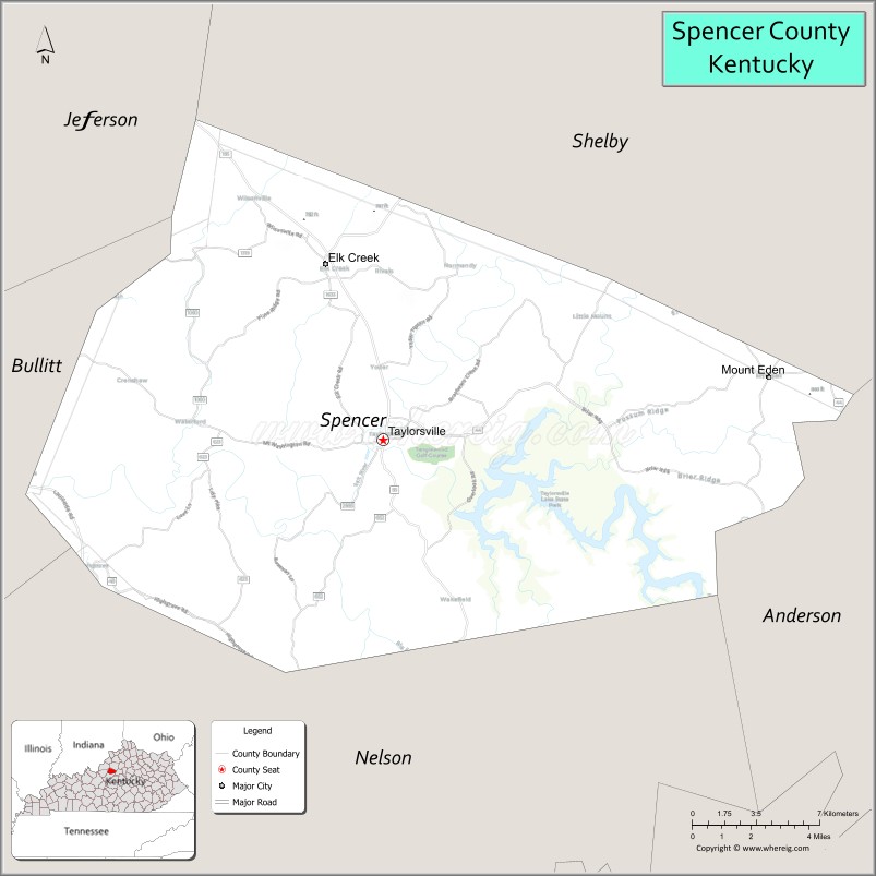
About Spencer County Map, Kentucky: The map showing the county boundary, county seat, major cities, highways, water bodies and neighbouring counties.
More Kentucky Maps & Info
Map of Spencer County, Kentucky
Spencer County is a county located in the U.S. state of Kentucky. It's county seat is Taylorsville. As per 2020 census, the population of Spencer County is 19916 people and population density is square miles. According to the United States Census Bureau, the county has a total area of 186 sq mi (482 km2). Spencer County was established on 1824.
Spencer County Facts
| Continent | North America |
| Country | United States |
| State | Kentucky |
| County Seat | Taylorsville |
| Largest City/Town | Taylorsville |
| Established | 1824 |
| Total Area | 187 sq mi (484 sq km) |
| Land Area | 183 sq mi (474 sq km) |
| Water Area | 4.5 sq mi (12 sq km) |
| Population | 19,490 (Census 2020) |
| Population Density | 106 people per sq mi |
| Time Zone | Eastern Time Zone (ET) |
| Major Highways | Kentucky Route 55, Kentucky Route 44, Kentucky Route 155, Bluegrass Parkway nearby area |
| Major Rivers | Salt River |
| Neighboring Counties | Jefferson County, Bullitt County, Nelson County, Anderson County, Shelby County |
| Famous For | Taylorsville Lake, horse farms, scenic Bluegrass countryside, and outdoor recreation |
| Top Attractions | Taylorsville Lake State Park, Taylorsville Lake Marina, Brashears Creek recreation areas, Elk Creek Vineyards nearby area, Taylorsville Historic District |
| Official Website | Official Website |
About Spencer County, Kentucky
Spencer County is located in north-central Kentucky within the Bluegrass region and was established in 1824. The county seat and largest city is Taylorsville. Spencer County is known for Taylorsville Lake recreation, rolling countryside, horse farms, outdoor tourism, and its peaceful location between Louisville and central Kentucky Bluegrass communities. ([en.wikipedia.org](https://en.wikipedia.org/wiki/Spencer_County%2C_Kentucky?utm_source=chatgpt.com))
Cities and Communities in Spencer County, Kentucky
| City/Town | Population | Latitude & Longitude |
|---|---|---|
| Taylorsville (county seat) | 1,500+ | 38.0317°N, 85.3425°W |
| Elk Creek | Rural Community | 38.0459°N, 85.2347°W |
| Fisherville Nearby Area | Regional Community | 38.1604°N, 85.4414°W |
| Little Mount | Historic Community | 38.0808°N, 85.3632°W |
| Waterford | Small Community | 37.9895°N, 85.4028°W |
| Wakefield | Rural Area | 38.0831°N, 85.2927°W |
| Mount Eden Nearby Area | Regional Area | 38.0737°N, 85.1032°W |
| Cedar Grove | Unincorporated | 38.0156°N, 85.2921°W |
Best Golf Courses in Spencer County, Kentucky
| Golf Course | Location | Latitude & Longitude |
|---|---|---|
| Taylorsville Country Club | Taylorsville | 38.0447°N, 85.3464°W |
| Persimmon Ridge Golf Club | Nearby Louisville Area | 38.2584°N, 85.4210°W |
| Long Run Golf Course | Nearby Louisville Area | 38.1386°N, 85.4541°W |
| Weissinger Hills Golf Course | Nearby Shelbyville | 38.2361°N, 85.2114°W |
What are Major Roads and Highways in Spencer County
Major highways connect Spencer County with Louisville, central Kentucky, and major Bluegrass recreation areas.
- Kentucky Route 55 - important north-south route through Taylorsville and nearby communities
- Kentucky Route 44 - regional connector roadway linking suburban and rural areas
- Kentucky Route 155 - scenic highway serving Taylorsville Lake recreation areas
- Bluegrass Parkway nearby area - transportation corridor connecting central Kentucky destinations
Neighboring Counties of Spencer County
- Jefferson County (northwest)
- Bullitt County (west)
- Nelson County (south)
- Anderson County (east)
- Shelby County (northeast)
What are Top Attractions in Spencer County, Kentucky
The county offers lake recreation, scenic countryside, wineries, outdoor parks, and peaceful Bluegrass tourism destinations.
| Main Sight Name | City | Famous For |
|---|---|---|
| Taylorsville Lake State Park | Taylorsville | Camping, hiking, boating, and fishing |
| Taylorsville Lake Marina | Taylorsville Area | Boat rentals and waterfront recreation |
| Brashears Creek Recreation Areas | Countywide | Fishing, kayaking, and scenic landscapes |
| Elk Creek Vineyards Nearby Area | Regional Area | Winery tours and countryside scenery |
| Taylorsville Historic District | Taylorsville | Historic courthouse and small-town charm |
| Salt River Scenic Areas | Countywide | Nature photography and outdoor recreation |
| Horse Farm Scenic Drives | Countywide | Bluegrass countryside and equestrian landscapes |
| Outdoor Hiking Trails | Countywide | Nature exploration and wildlife viewing |
| Community Festivals and Events | Taylorsville Area | Local traditions and seasonal celebrations |
| Fishing and Boating Areas | Taylorsville Lake | Water sports and family recreation |
Distance from Spencer County to Nearby Cities
The following distances are measured by road (driving).
- Taylorsville to Louisville, Kentucky - 32 mi (51 km)
- Taylorsville to Shelbyville, Kentucky - 26 mi (42 km)
- Taylorsville to Frankfort, Kentucky - 42 mi (68 km)
- Taylorsville to Lexington, Kentucky - 67 mi (108 km)
- Taylorsville to Bowling Green, Kentucky - 102 mi (164 km)
- Taylorsville to Cincinnati, Ohio - 118 mi (190 km)
- Taylorsville to Indianapolis, Indiana - 149 mi (240 km)
- Taylorsville to Nashville, Tennessee - 173 mi (278 km)
- Taylorsville to Knoxville, Tennessee - 236 mi (380 km)
- Taylorsville to Columbus, Ohio - 229 mi (368 km)
- Taylorsville to St. Louis, Missouri - 287 mi (462 km)
- Taylorsville to Chicago, Illinois - 318 mi (512 km)
References
- Spencer County Official Website
- Spencer County, Kentucky - Wikipedia
- U.S. Census Bureau QuickFacts
- Taylorsville Lake State Park
- Kentucky Tourism
- Adair County Map
- Allen County Map
- Anderson County Map
- Ballard County Map
- Barren County Map
- Bath County Map
- Bell County Map
- Boone County Map
- Bourbon County Map
- Boyd County Map
- Boyle County Map
- Bracken County Map
- Breathitt County Map
- Breckinridge County Map
- Bullitt County Map
- Butler County Map
- Caldwell County Map
- Calloway County Map
- Campbell County Map
- Carlisle County Map
- Carroll County Map
- Carter County Map
- Casey County Map
- Christian County Map
- Clark County Map
- Clay County Map
- Clinton County Map
- Crittenden County Map
- Cumberland County Map
- Daviess County Map
- Edmonson County Map
- Elliott County Map
- Estill County Map
- Fayette County Map
- Fleming County Map
- Floyd County Map
- Franklin County Map
- Fulton County Map
- Gallatin County Map
- Garrard County Map
- Grant County Map
- Graves County Map
- Grayson County Map
- Green County Map
- Greenup County Map
- Hancock County Map
- Hardin County Map
- Harlan County Map
- Harrison County Map
- Hart County Map
- Henderson County Map
- Henry County Map
- Hickman County Map
- Hopkins County Map
- Jackson County Map
- Jefferson County Map
- Jessamine County Map
- Johnson County Map
- Kenton County Map
- Knott County Map
- Knox County Map
- LaRue County Map
- Laurel County Map
- Lawrence County Map
- Lee County Map
- Leslie County Map
- Letcher County Map
- Lewis County Map
- Lincoln County Map
- Livingston County Map
- Logan County Map
- Lyon County Map
- McCracken County Map
- McCreary County Map
- McLean County Map
- Madison County Map
- Magoffin County Map
- Marion County Map
- Marshall County Map
- Martin County Map
- Mason County Map
- Meade County Map
- Menifee County Map
- Mercer County Map
- Metcalfe County Map
- Monroe County Map
- Montgomery County Map
- Morgan County Map
- Muhlenberg County Map
- Nelson County Map
- Nicholas County Map
- Ohio County Map
- Oldham County Map
- Owen County Map
- Owsley County Map
- Pendleton County Map
- Perry County Map
- Pike County Map
- Powell County Map
- Pulaski County Map
- Robertson County Map
- Rockcastle County Map
- Rowan County Map
- Russell County Map
- Scott County Map
- Shelby County Map
- Simpson County Map
- Spencer County Map
- Taylor County Map
- Todd County Map
- Trigg County Map
- Trimble County Map
- Union County Map
- Warren County Map
- Washington County Map
- Wayne County Map
- Webster County Map
- Whitley County Map
- Wolfe County Map
- Woodford County Map
- Alabama Counties
- Alaska boroughs
- Arizona Counties
- Arkansas Counties
- California County Map
- Colorado Counties
- Connecticut Counties
- Delaware Counties
- Florida County Map
- Georgia County Map
- Hawaii Counties
- Idaho Counties
- Illinois Counties
- Indiana Counties
- Iowa Counties
- Kansas Counties
- Kentucky Counties
- Louisiana Counties
- Maine Counties
- Maryland Counties
- Massachusetts Counties
- Michigan County Map
- Minnesota Counties
- Mississippi Counties
- Missouri Counties
- Montana Counties
- Nebraska Counties
- Nevada Counties
- New York Counties
- New Hampshire Counties
- New Jersey Counties
- New Mexico Counties
- North Carolina Counties
- North Dakota Counties
- Ohio County Map
- Oklahoma Counties
- Oregon Counties
- Pennsylvania Counties
- Rhode Island Counties
- South Carolina Counties
- South Dakota Counties
- Map of Tennessee
- Texas County Map
- Utah Counties
- Vermont Counties
- Virginia Counties
- Washington Counties
- West Virginia Counties
- Wisconsin Counties
- Wyoming Counties