Map of Estill County - Estill County is a county located in the U.S. state of Kentucky. Estill County Map showing cities, highways, important places and water bodies. Get Where is Estill County located in the map, major cities in Estill county, population, areas, and places of interest.
Map of Estill County, Kentucky
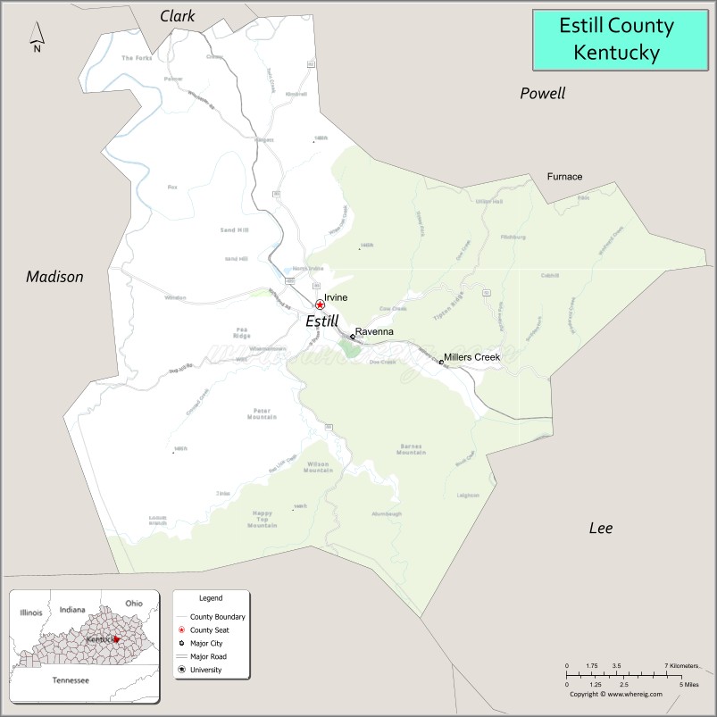
About Estill County Map, Kentucky: The map showing the county boundary, county seat, major cities, highways, water bodies and neighbouring counties.
More Kentucky Maps & Info
Map of Estill County, Kentucky
Estill County is a county located in the U.S. state of Kentucky. It's county seat is Irvine. As per 2020 census, the population of Estill County is 14092 people and population density is square miles. According to the United States Census Bureau, the county has a total area of 254 sq mi (658 km2). Estill County was established on 1808.
Estill County Facts
| Continent | North America |
| Country | United States |
| State | Kentucky |
| County Seat | Irvine |
| Largest City/Town | Irvine |
| Established | 1808 |
| Total Area | 256 sq mi (663 sq km) |
| Land Area | 253 sq mi (655 sq km) |
| Water Area | 3 sq mi (8 sq km) |
| Population | 14,163 (Census 2020) |
| Population Density | 56 people per sq mi |
| Time Zone | Eastern Time Zone (ET) |
| Major Highways | Kentucky Route 52, Kentucky Route 89, Kentucky Route 82, Kentucky Route 499 |
| Major Rivers | Kentucky River, Red River nearby area |
| Neighboring Counties | Madison County, Clark County, Powell County, Lee County, Jackson County |
| Famous For | Appalachian foothills, Kentucky River scenery, historic rail heritage, and outdoor recreation |
| Top Attractions | Kentucky River recreation, Irvine Historic District, Fitchburg Furnace, Lily Mountain area, scenic mountain drives |
| Official Website | Official Website |
About Estill County, Kentucky
Estill County is located in eastern Kentucky within the Appalachian foothills and was established in 1808 from parts of Clark and Madison counties. The county seat and largest city is Irvine. Estill County is known for its scenic Kentucky River landscapes, forested hills, outdoor recreation, railroad history, and strong Appalachian heritage. :contentReference[oaicite:0]{index=0}
Cities and Communities in Estill County, Kentucky
| City/Town | Population | Latitude & Longitude |
|---|---|---|
| Irvine (county seat) | 2,300+ | 37.7001°N, 83.9738°W |
| Ravenna | 600+ | 37.6851°N, 83.9505°W |
| Wisemantown | Unincorporated | 37.7370°N, 84.0164°W |
| Fitchburg | Historic Community | 37.6324°N, 83.8682°W |
| Lilly Nearby Area | Regional Community | 37.7462°N, 83.8907°W |
| West Irvine | Unincorporated | 37.6992°N, 83.9899°W |
| Cobhill | Historic Community | 37.7610°N, 84.0362°W |
| Crystal | Unincorporated | 37.6417°N, 83.9808°W |
Best Golf Courses in Estill County, Kentucky
| Golf Course | Location | Latitude & Longitude |
|---|---|---|
| Raven Crest Golf Course | Nearby Ravenna | 37.6848°N, 83.9445°W |
| Gibson Bay Golf Course | Nearby Richmond | 37.7660°N, 84.3018°W |
| Berea Country Club | Nearby Berea | 37.5604°N, 84.2967°W |
| Eagle Trace Golf Course | Nearby Morehead | 38.1915°N, 83.4378°W |
What are Major Roads and Highways in Estill County
Major highways connect Estill County with eastern Kentucky communities and the Bluegrass region.
- Kentucky Route 52 - major east-west route through Irvine and Ravenna
- Kentucky Route 89 - scenic north-south highway through Appalachian foothill communities
- Kentucky Route 82 - important regional connector through forested countryside
- Kentucky Route 499 - rural connector serving smaller communities and farmland areas
Neighboring Counties of Estill County
- Madison County (southwest)
- Clark County (northwest)
- Powell County (north)
- Lee County (east)
- Jackson County (south)
What are Top Attractions in Estill County, Kentucky
The county offers scenic river valleys, Appalachian history, hiking opportunities, and historic landmarks.
| Main Sight Name | City | Famous For |
|---|---|---|
| Kentucky River Recreation Area | Countywide | Fishing, kayaking, and scenic river views |
| Irvine Historic District | Irvine | Historic downtown architecture and local shops |
| Fitchburg Furnace | Fitchburg | Historic iron furnace and industrial heritage |
| Lilly Mountain Area | Lilly Area | Hiking and Appalachian scenery |
| Scenic Mountain Drives | Countywide | Rolling hills and forest overlooks |
| Estill County Courthouse | Irvine | Historic county landmark |
| Kentucky River Lock Areas | Countywide | Historic river transportation sites |
| Ravenna Rail Heritage Sites | Ravenna | Railroad history and Appalachian culture |
| Outdoor Recreation Areas | Countywide | Camping, hiking, and hunting opportunities |
| Appalachian Countryside | Countywide | Nature photography and rural scenery |
Distance from Estill County to Nearby Cities
The following distances are measured by road (driving).
- Irvine to Richmond, Kentucky - 24 mi (39 km)
- Irvine to Lexington, Kentucky - 43 mi (69 km)
- Irvine to Winchester, Kentucky - 33 mi (53 km)
- Irvine to Morehead, Kentucky - 57 mi (92 km)
- Irvine to Louisville, Kentucky - 115 mi (185 km)
- Irvine to Cincinnati, Ohio - 113 mi (182 km)
- Irvine to Huntington, West Virginia - 108 mi (174 km)
- Irvine to Charleston, West Virginia - 140 mi (225 km)
- Irvine to Knoxville, Tennessee - 165 mi (266 km)
- Irvine to Nashville, Tennessee - 228 mi (367 km)
- Irvine to Columbus, Ohio - 184 mi (296 km)
- Irvine to Indianapolis, Indiana - 214 mi (344 km)
References
- Estill County Official Website
- Estill County, Kentucky - Wikipedia
- U.S. Census Bureau QuickFacts
- Estill County Chamber of Commerce
- History of Estill County
- Adair County Map
- Allen County Map
- Anderson County Map
- Ballard County Map
- Barren County Map
- Bath County Map
- Bell County Map
- Boone County Map
- Bourbon County Map
- Boyd County Map
- Boyle County Map
- Bracken County Map
- Breathitt County Map
- Breckinridge County Map
- Bullitt County Map
- Butler County Map
- Caldwell County Map
- Calloway County Map
- Campbell County Map
- Carlisle County Map
- Carroll County Map
- Carter County Map
- Casey County Map
- Christian County Map
- Clark County Map
- Clay County Map
- Clinton County Map
- Crittenden County Map
- Cumberland County Map
- Daviess County Map
- Edmonson County Map
- Elliott County Map
- Estill County Map
- Fayette County Map
- Fleming County Map
- Floyd County Map
- Franklin County Map
- Fulton County Map
- Gallatin County Map
- Garrard County Map
- Grant County Map
- Graves County Map
- Grayson County Map
- Green County Map
- Greenup County Map
- Hancock County Map
- Hardin County Map
- Harlan County Map
- Harrison County Map
- Hart County Map
- Henderson County Map
- Henry County Map
- Hickman County Map
- Hopkins County Map
- Jackson County Map
- Jefferson County Map
- Jessamine County Map
- Johnson County Map
- Kenton County Map
- Knott County Map
- Knox County Map
- LaRue County Map
- Laurel County Map
- Lawrence County Map
- Lee County Map
- Leslie County Map
- Letcher County Map
- Lewis County Map
- Lincoln County Map
- Livingston County Map
- Logan County Map
- Lyon County Map
- McCracken County Map
- McCreary County Map
- McLean County Map
- Madison County Map
- Magoffin County Map
- Marion County Map
- Marshall County Map
- Martin County Map
- Mason County Map
- Meade County Map
- Menifee County Map
- Mercer County Map
- Metcalfe County Map
- Monroe County Map
- Montgomery County Map
- Morgan County Map
- Muhlenberg County Map
- Nelson County Map
- Nicholas County Map
- Ohio County Map
- Oldham County Map
- Owen County Map
- Owsley County Map
- Pendleton County Map
- Perry County Map
- Pike County Map
- Powell County Map
- Pulaski County Map
- Robertson County Map
- Rockcastle County Map
- Rowan County Map
- Russell County Map
- Scott County Map
- Shelby County Map
- Simpson County Map
- Spencer County Map
- Taylor County Map
- Todd County Map
- Trigg County Map
- Trimble County Map
- Union County Map
- Warren County Map
- Washington County Map
- Wayne County Map
- Webster County Map
- Whitley County Map
- Wolfe County Map
- Woodford County Map
- Alabama Counties
- Alaska boroughs
- Arizona Counties
- Arkansas Counties
- California County Map
- Colorado Counties
- Connecticut Counties
- Delaware Counties
- Florida County Map
- Georgia County Map
- Hawaii Counties
- Idaho Counties
- Illinois Counties
- Indiana Counties
- Iowa Counties
- Kansas Counties
- Kentucky Counties
- Louisiana Counties
- Maine Counties
- Maryland Counties
- Massachusetts Counties
- Michigan County Map
- Minnesota Counties
- Mississippi Counties
- Missouri Counties
- Montana Counties
- Nebraska Counties
- Nevada Counties
- New York Counties
- New Hampshire Counties
- New Jersey Counties
- New Mexico Counties
- North Carolina Counties
- North Dakota Counties
- Ohio County Map
- Oklahoma Counties
- Oregon Counties
- Pennsylvania Counties
- Rhode Island Counties
- South Carolina Counties
- South Dakota Counties
- Map of Tennessee
- Texas County Map
- Utah Counties
- Vermont Counties
- Virginia Counties
- Washington Counties
- West Virginia Counties
- Wisconsin Counties
- Wyoming Counties