Map of Graves County - Graves County is a county located in the U.S. state of Kentucky. Graves County Map showing cities, highways, important places and water bodies. Get Where is Graves County located in the map, major cities in Graves county, population, areas, and places of interest.
Map of Graves County, Kentucky
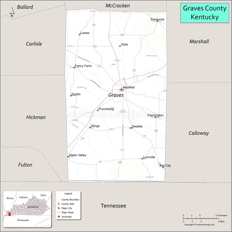
About Graves County Map, Kentucky: The map showing the county boundary, county seat, major cities, highways, water bodies and neighbouring counties.
More Kentucky Maps & Info
Map of Graves County, Kentucky
Graves County is a county located in the U.S. state of Kentucky. It's county seat is Mayfield. As per 2020 census, the population of Graves County is 36615 people and population density is square miles. According to the United States Census Bureau, the county has a total area of 556 sq mi (1,440 km2). Graves County was established on 1824.
Graves County Facts
| Continent | North America |
| Country | United States |
| State | Kentucky |
| County Seat | Mayfield |
| Largest City/Town | Mayfield |
| Established | 1824 |
| Total Area | 557 sq mi (1,443 sq km) |
| Land Area | 552 sq mi (1,430 sq km) |
| Water Area | 5 sq mi (13 sq km) |
| Population | 36,649 (Census 2020) |
| Population Density | 66 people per sq mi |
| Time Zone | Central Time Zone (CT) |
| Major Highways | U.S. Route 45, U.S. Route 45E, Kentucky Route 80, Kentucky Route 121, Interstate 69 nearby area |
| Major Rivers | Clarks River, Obion Creek nearby area |
| Neighboring Counties | McCracken County, Marshall County, Calloway County, Hickman County, Carlisle County, Weakley County (TN), Henry County (TN) |
| Famous For | Agriculture, Mayfield history, tornado recovery resilience, and western Kentucky manufacturing |
| Top Attractions | Mayfield Courthouse Square, Wooldridge Monuments, Clarks River National Wildlife Refuge nearby area, Ice House Gallery, Historic Downtown Mayfield |
| Official Website | Official Website |
About Graves County, Kentucky
Graves County is located in southwestern Kentucky and was established in 1824. The county seat and largest city is Mayfield. Graves County is known for its rich agricultural economy, historic downtown districts, strong manufacturing sector, and resilient recovery following the devastating tornado outbreak of December 2021. :contentReference[oaicite:0]{index=0}
Cities and Communities in Graves County, Kentucky
| City/Town | Population | Latitude & Longitude |
|---|---|---|
| Mayfield (county seat) | 10,000+ | 36.7417°N, 88.6450°W |
| Wingo | 600+ | 36.6401°N, 88.7389°W |
| Fancy Farm | Census Community | 36.8012°N, 88.7859°W |
| Farmington | Census Community | 36.6698°N, 88.5297°W |
| Sedalia | Census Community | 36.5731°N, 88.5998°W |
| Symsonia | Census Community | 36.9098°N, 88.5148°W |
| Lowes | Unincorporated | 36.8723°N, 88.7730°W |
| Water Valley | Historic Community | 36.5721°N, 88.8091°W |
Best Golf Courses in Graves County, Kentucky
| Golf Course | Location | Latitude & Longitude |
|---|---|---|
| Mayfield Graves Country Club | Mayfield | 36.7294°N, 88.6591°W |
| Paxton Park Golf Course | Nearby Paducah | 37.0647°N, 88.6548°W |
| Benton Golf & Country Club | Nearby Benton | 36.8791°N, 88.3578°W |
| Dogwood Hills Golf Resort | Nearby Flatwoods, Tennessee | 35.5074°N, 88.8206°W |
What are Major Roads and Highways in Graves County
Major highways connect Graves County with Paducah, Tennessee, and other western Kentucky communities.
- U.S. Route 45 - major north-south highway through Mayfield and western Kentucky
- U.S. Route 45E - connector route linking Kentucky with western Tennessee
- Kentucky Route 80 - important east-west highway serving regional transportation
- Kentucky Route 121 - major local connector through Graves County communities
- Interstate 69 nearby area - regional interstate corridor providing broader transportation access
Neighboring Counties of Graves County
- McCracken County (north)
- Marshall County (northeast)
- Calloway County (southeast)
- Hickman County (southwest)
- Carlisle County (northwest)
- Weakley County, Tennessee (south)
- Henry County, Tennessee (southeast)
What are Top Attractions in Graves County, Kentucky
The county features historic downtown areas, wildlife recreation, local museums, and scenic countryside attractions.
| Main Sight Name | City | Famous For |
|---|---|---|
| Mayfield Courthouse Square | Mayfield | Historic downtown district and local events |
| Wooldridge Monuments | Mayfield Area | Historic family memorial sculptures |
| Clarks River National Wildlife Refuge Nearby Area | Countywide | Wildlife observation, birdwatching, and wetlands |
| Ice House Gallery | Mayfield | Local arts and cultural exhibits |
| Historic Downtown Mayfield | Mayfield | Restaurants, boutiques, and historic architecture |
| Fancy Farm Area | Fancy Farm | Historic church picnic and political events |
| Mayfield Consumer Products Area | Mayfield | Regional manufacturing history |
| Clarks River Scenic Area | Countywide | Fishing and countryside scenery |
| County Heritage Museums | Mayfield Area | Regional history and cultural exhibits |
| Rural Scenic Drives | Countywide | Western Kentucky farmland landscapes |
Distance from Graves County to Nearby Cities
The following distances are measured by road (driving).
- Mayfield to Paducah, Kentucky - 25 mi (40 km)
- Mayfield to Murray, Kentucky - 24 mi (39 km)
- Mayfield to Jackson, Tennessee - 88 mi (142 km)
- Mayfield to Nashville, Tennessee - 135 mi (217 km)
- Mayfield to Evansville, Indiana - 119 mi (191 km)
- Mayfield to Memphis, Tennessee - 171 mi (275 km)
- Mayfield to Louisville, Kentucky - 228 mi (367 km)
- Mayfield to Lexington, Kentucky - 255 mi (410 km)
- Mayfield to St. Louis, Missouri - 180 mi (290 km)
- Mayfield to Little Rock, Arkansas - 223 mi (359 km)
- Mayfield to Indianapolis, Indiana - 260 mi (418 km)
- Mayfield to Cincinnati, Ohio - 322 mi (518 km)
References
- Graves County Official Website
- Graves County, Kentucky - Wikipedia
- U.S. Census Bureau QuickFacts
- Clarks River National Wildlife Refuge
- Graves County Economic Development
- Adair County Map
- Allen County Map
- Anderson County Map
- Ballard County Map
- Barren County Map
- Bath County Map
- Bell County Map
- Boone County Map
- Bourbon County Map
- Boyd County Map
- Boyle County Map
- Bracken County Map
- Breathitt County Map
- Breckinridge County Map
- Bullitt County Map
- Butler County Map
- Caldwell County Map
- Calloway County Map
- Campbell County Map
- Carlisle County Map
- Carroll County Map
- Carter County Map
- Casey County Map
- Christian County Map
- Clark County Map
- Clay County Map
- Clinton County Map
- Crittenden County Map
- Cumberland County Map
- Daviess County Map
- Edmonson County Map
- Elliott County Map
- Estill County Map
- Fayette County Map
- Fleming County Map
- Floyd County Map
- Franklin County Map
- Fulton County Map
- Gallatin County Map
- Garrard County Map
- Grant County Map
- Graves County Map
- Grayson County Map
- Green County Map
- Greenup County Map
- Hancock County Map
- Hardin County Map
- Harlan County Map
- Harrison County Map
- Hart County Map
- Henderson County Map
- Henry County Map
- Hickman County Map
- Hopkins County Map
- Jackson County Map
- Jefferson County Map
- Jessamine County Map
- Johnson County Map
- Kenton County Map
- Knott County Map
- Knox County Map
- LaRue County Map
- Laurel County Map
- Lawrence County Map
- Lee County Map
- Leslie County Map
- Letcher County Map
- Lewis County Map
- Lincoln County Map
- Livingston County Map
- Logan County Map
- Lyon County Map
- McCracken County Map
- McCreary County Map
- McLean County Map
- Madison County Map
- Magoffin County Map
- Marion County Map
- Marshall County Map
- Martin County Map
- Mason County Map
- Meade County Map
- Menifee County Map
- Mercer County Map
- Metcalfe County Map
- Monroe County Map
- Montgomery County Map
- Morgan County Map
- Muhlenberg County Map
- Nelson County Map
- Nicholas County Map
- Ohio County Map
- Oldham County Map
- Owen County Map
- Owsley County Map
- Pendleton County Map
- Perry County Map
- Pike County Map
- Powell County Map
- Pulaski County Map
- Robertson County Map
- Rockcastle County Map
- Rowan County Map
- Russell County Map
- Scott County Map
- Shelby County Map
- Simpson County Map
- Spencer County Map
- Taylor County Map
- Todd County Map
- Trigg County Map
- Trimble County Map
- Union County Map
- Warren County Map
- Washington County Map
- Wayne County Map
- Webster County Map
- Whitley County Map
- Wolfe County Map
- Woodford County Map
- Alabama Counties
- Alaska boroughs
- Arizona Counties
- Arkansas Counties
- California County Map
- Colorado Counties
- Connecticut Counties
- Delaware Counties
- Florida County Map
- Georgia County Map
- Hawaii Counties
- Idaho Counties
- Illinois Counties
- Indiana Counties
- Iowa Counties
- Kansas Counties
- Kentucky Counties
- Louisiana Counties
- Maine Counties
- Maryland Counties
- Massachusetts Counties
- Michigan County Map
- Minnesota Counties
- Mississippi Counties
- Missouri Counties
- Montana Counties
- Nebraska Counties
- Nevada Counties
- New York Counties
- New Hampshire Counties
- New Jersey Counties
- New Mexico Counties
- North Carolina Counties
- North Dakota Counties
- Ohio County Map
- Oklahoma Counties
- Oregon Counties
- Pennsylvania Counties
- Rhode Island Counties
- South Carolina Counties
- South Dakota Counties
- Map of Tennessee
- Texas County Map
- Utah Counties
- Vermont Counties
- Virginia Counties
- Washington Counties
- West Virginia Counties
- Wisconsin Counties
- Wyoming Counties