Map of Anderson County - Anderson County is a county located in the U.S. state of Kentucky. Anderson County Map showing cities, highways, important places and water bodies. Get Where is Anderson County located in the map, major cities in Anderson county, population, areas, and places of interest.
Map of Anderson County, Kentucky
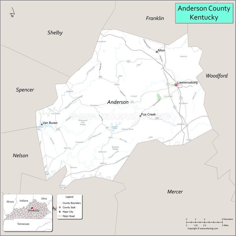
About Anderson County Map, Kentucky: The map showing the county boundary, county seat, major cities, highways, water bodies and neighbouring counties.
More Kentucky Maps & Info
Map of Anderson County, Kentucky
Anderson County is a county located in the U.S. state of Kentucky. It's county seat is Lawrenceburg. As per 2020 census, the population of Anderson County is 24035 people and population density is square miles. According to the United States Census Bureau, the county has a total area of 203 sq mi (526 km2). Anderson County was established on 1827.
Anderson County Facts
| Continent | North America |
| Country | United States |
| State | Kentucky |
| County Seat | Lawrenceburg |
| Largest City/Town | Lawrenceburg |
| Established | 1827 |
| Total Area | 204 sq mi (528 sq km) |
| Land Area | 202 sq mi (523 sq km) |
| Water Area | 2.4 sq mi (6 sq km) |
| Population | 23,852 (Census 2020) |
| Population Density | 118 people per sq mi |
| Time Zone | Eastern Time Zone (ET) |
| Major Highways | Bluegrass Parkway, U.S. Route 127, KY Route 44, U.S. Route 62 |
| Major Rivers | Kentucky River, Beaver Creek |
| Neighboring Counties | Franklin County, Woodford County, Mercer County, Washington County, Spencer County, Shelby County |
| Famous For | Bourbon distilleries, horse farms, Bluegrass scenery, and Lawrenceburg |
| Top Attractions | Wild Turkey Distillery, Four Roses Distillery, Downtown Lawrenceburg, Kentucky River Palisades, Lovers Leap Vineyards |
| Official Website | Official Website |
About Anderson County, Kentucky
Anderson County is located in the Bluegrass region of central Kentucky and was established in 1827. The county seat and largest city is Lawrenceburg. Anderson County is known for bourbon production, scenic horse farms, rolling hills, and its location along the Kentucky River. :contentReference[oaicite:0]{index=0}
Cities and Communities in Anderson County, Kentucky
| City/Town | Population | Latitude & Longitude |
|---|---|---|
| Lawrenceburg (county seat) | 11,000+ | 38.0373°N, 84.8966°W |
| Alton | Unincorporated | 38.0172°N, 84.9583°W |
| Ballard | Unincorporated | 38.1031°N, 84.9092°W |
| Glensboro | Unincorporated | 38.1156°N, 84.8281°W |
| McBrayer | Unincorporated | 38.0653°N, 84.9161°W |
| Stringtown | Unincorporated | 38.0208°N, 84.8508°W |
| Tyrone | Historic Community | 38.0942°N, 84.8617°W |
| Ripyville | Historic Community | 38.0119°N, 84.8775°W |
Best Golf Courses in Anderson County, Kentucky
| Golf Course | Location | Latitude & Longitude |
|---|---|---|
| Wild Turkey Trace Golf Course | Lawrenceburg | 38.0387°N, 84.9021°W |
| Lakeside Golf Course | Nearby Frankfort | 38.1890°N, 84.8754°W |
| Cherry Blossom Golf & Country Club | Nearby Georgetown | 38.2052°N, 84.5455°W |
What are Major Roads and Highways in Anderson County
Major highways provide access to central Kentucky cities and bourbon country attractions.
- Bluegrass Parkway - major east-west parkway connecting Lawrenceburg with Lexington and western Kentucky
- U.S. Route 127 - north-south route linking Lawrenceburg with Frankfort and Danville
- U.S. Route 62 - regional highway serving Anderson County communities and surrounding counties
- KY Route 44 - important connector route through Lawrenceburg and nearby areas
Neighboring Counties of Anderson County
- Franklin County (north)
- Woodford County (northeast)
- Mercer County (south)
- Washington County (southwest)
- Spencer County (west)
- Shelby County (northwest)
What are Top Attractions in Anderson County, Kentucky
The county is known for bourbon tourism, scenic countryside, and historic attractions.
| Main Sight Name | City | Famous For |
|---|---|---|
| Wild Turkey Distillery | Lawrenceburg | Bourbon tours and Kentucky whiskey history |
| Four Roses Distillery | Lawrenceburg | Historic bourbon distillery and tasting experiences |
| Downtown Lawrenceburg | Lawrenceburg | Historic architecture, shops, and restaurants |
| Kentucky River Palisades | Anderson County Area | Scenic river cliffs and outdoor recreation |
| Lovers Leap Vineyards & Winery | Lawrenceburg | Local wine tasting and vineyard scenery |
| Anderson County Courthouse | Lawrenceburg | Historic county landmark |
| Century Bank Park | Lawrenceburg | Community events and recreation |
| Rising Sons Home Farm Winery | Lawrenceburg Area | Kentucky farm winery and local products |
| Beaver Lake Recreation Area | Anderson County | Fishing and outdoor recreation |
| Bluegrass Scenic Countryside | Countywide | Horse farms and rolling Kentucky landscapes |
Distance from Anderson County to Nearby Cities
The following distances are measured by road (driving).
- Lawrenceburg to Frankfort, Kentucky - 15 mi (24 km)
- Lawrenceburg to Lexington, Kentucky - 32 mi (51 km)
- Lawrenceburg to Louisville, Kentucky - 52 mi (84 km)
- Lawrenceburg to Danville, Kentucky - 32 mi (51 km)
- Lawrenceburg to Shelbyville, Kentucky - 29 mi (47 km)
- Lawrenceburg to Bardstown, Kentucky - 38 mi (61 km)
- Lawrenceburg to Georgetown, Kentucky - 33 mi (53 km)
- Lawrenceburg to Versailles, Kentucky - 18 mi (29 km)
- Lawrenceburg to Harrodsburg, Kentucky - 24 mi (39 km)
- Lawrenceburg to Richmond, Kentucky - 44 mi (71 km)
- Lawrenceburg to Elizabethtown, Kentucky - 62 mi (100 km)
- Lawrenceburg to Cincinnati, Ohio - 87 mi (140 km)
References
- Anderson County Official Website
- Anderson County, Kentucky - Wikipedia
- United States Census Bureau
- Kentucky Atlas and Gazetteer
- USAFacts Population Data
- Adair County Map
- Allen County Map
- Anderson County Map
- Ballard County Map
- Barren County Map
- Bath County Map
- Bell County Map
- Boone County Map
- Bourbon County Map
- Boyd County Map
- Boyle County Map
- Bracken County Map
- Breathitt County Map
- Breckinridge County Map
- Bullitt County Map
- Butler County Map
- Caldwell County Map
- Calloway County Map
- Campbell County Map
- Carlisle County Map
- Carroll County Map
- Carter County Map
- Casey County Map
- Christian County Map
- Clark County Map
- Clay County Map
- Clinton County Map
- Crittenden County Map
- Cumberland County Map
- Daviess County Map
- Edmonson County Map
- Elliott County Map
- Estill County Map
- Fayette County Map
- Fleming County Map
- Floyd County Map
- Franklin County Map
- Fulton County Map
- Gallatin County Map
- Garrard County Map
- Grant County Map
- Graves County Map
- Grayson County Map
- Green County Map
- Greenup County Map
- Hancock County Map
- Hardin County Map
- Harlan County Map
- Harrison County Map
- Hart County Map
- Henderson County Map
- Henry County Map
- Hickman County Map
- Hopkins County Map
- Jackson County Map
- Jefferson County Map
- Jessamine County Map
- Johnson County Map
- Kenton County Map
- Knott County Map
- Knox County Map
- LaRue County Map
- Laurel County Map
- Lawrence County Map
- Lee County Map
- Leslie County Map
- Letcher County Map
- Lewis County Map
- Lincoln County Map
- Livingston County Map
- Logan County Map
- Lyon County Map
- McCracken County Map
- McCreary County Map
- McLean County Map
- Madison County Map
- Magoffin County Map
- Marion County Map
- Marshall County Map
- Martin County Map
- Mason County Map
- Meade County Map
- Menifee County Map
- Mercer County Map
- Metcalfe County Map
- Monroe County Map
- Montgomery County Map
- Morgan County Map
- Muhlenberg County Map
- Nelson County Map
- Nicholas County Map
- Ohio County Map
- Oldham County Map
- Owen County Map
- Owsley County Map
- Pendleton County Map
- Perry County Map
- Pike County Map
- Powell County Map
- Pulaski County Map
- Robertson County Map
- Rockcastle County Map
- Rowan County Map
- Russell County Map
- Scott County Map
- Shelby County Map
- Simpson County Map
- Spencer County Map
- Taylor County Map
- Todd County Map
- Trigg County Map
- Trimble County Map
- Union County Map
- Warren County Map
- Washington County Map
- Wayne County Map
- Webster County Map
- Whitley County Map
- Wolfe County Map
- Woodford County Map
- Alabama Counties
- Alaska boroughs
- Arizona Counties
- Arkansas Counties
- California County Map
- Colorado Counties
- Connecticut Counties
- Delaware Counties
- Florida County Map
- Georgia County Map
- Hawaii Counties
- Idaho Counties
- Illinois Counties
- Indiana Counties
- Iowa Counties
- Kansas Counties
- Kentucky Counties
- Louisiana Counties
- Maine Counties
- Maryland Counties
- Massachusetts Counties
- Michigan County Map
- Minnesota Counties
- Mississippi Counties
- Missouri Counties
- Montana Counties
- Nebraska Counties
- Nevada Counties
- New York Counties
- New Hampshire Counties
- New Jersey Counties
- New Mexico Counties
- North Carolina Counties
- North Dakota Counties
- Ohio County Map
- Oklahoma Counties
- Oregon Counties
- Pennsylvania Counties
- Rhode Island Counties
- South Carolina Counties
- South Dakota Counties
- Map of Tennessee
- Texas County Map
- Utah Counties
- Vermont Counties
- Virginia Counties
- Washington Counties
- West Virginia Counties
- Wisconsin Counties
- Wyoming Counties