Map of Monroe County - Monroe County is a county located in the U.S. state of Kentucky. Monroe County Map showing cities, highways, important places and water bodies. Get Where is Monroe County located in the map, major cities in Monroe county, population, areas, and places of interest.
Map of Monroe County, Kentucky
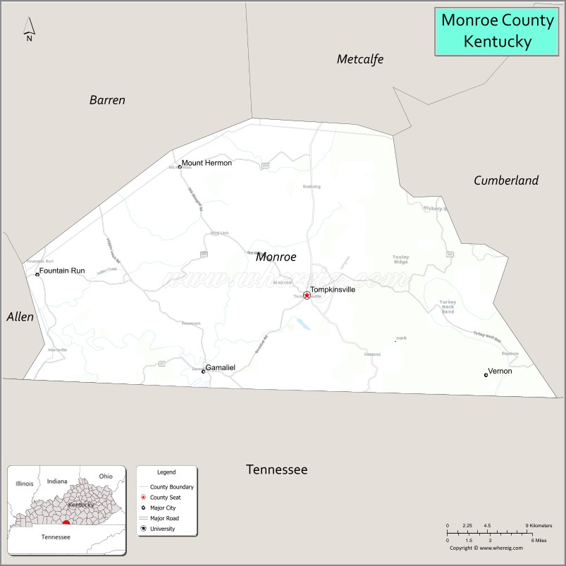
About Monroe County Map, Kentucky: The map showing the county boundary, county seat, major cities, highways, water bodies and neighbouring counties.
More Kentucky Maps & Info
Map of Monroe County, Kentucky
Monroe County is a county located in the U.S. state of Kentucky. It's county seat is Tompkinsville. As per 2020 census, the population of Monroe County is 11233 people and population density is square miles. According to the United States Census Bureau, the county has a total area of 331 sq mi (857 km2). Monroe County was established on 1820.
Monroe County Facts
| Continent | North America |
| Country | United States |
| State | Kentucky |
| County Seat | Tompkinsville |
| Largest City/Town | Tompkinsville |
| Established | 1820 |
| Total Area | 332 sq mi (860 sq km) |
| Land Area | 329 sq mi (852 sq km) |
| Water Area | 2.7 sq mi (7 sq km) |
| Population | 10,963 (Census 2020) |
| Population Density | 33 people per sq mi |
| Time Zone | Central Time Zone (CT) |
| Major Highways | Kentucky Route 63, Kentucky Route 100, Kentucky Route 163, Kentucky Route 90 |
| Major Rivers | Cumberland River tributaries |
| Neighboring Counties | Barren County, Metcalfe County, Cumberland County, Clay County (TN), Macon County (TN), Allen County |
| Famous For | Rural Kentucky landscapes, Dale Hollow Lake nearby area, agriculture, and south-central Kentucky heritage |
| Top Attractions | Dale Hollow Lake nearby area, Tompkinsville Historic District, Old Mulkey Meetinghouse State Historic Site, Monroe County Museum, scenic countryside drives |
| Official Website | Official Website |
About Monroe County, Kentucky
Monroe County is located in south-central Kentucky along the Tennessee border and was established in 1820. The county seat and largest city is Tompkinsville. Monroe County is known for rolling farmland, rural landscapes, historic churches, outdoor recreation near Dale Hollow Lake, and its strong agricultural traditions. ([en.wikipedia.org](https://en.wikipedia.org/wiki/Monroe_County%2C_Kentucky?utm_source=chatgpt.com))
Cities and Communities in Monroe County, Kentucky
| City/Town | Population | Latitude & Longitude |
|---|---|---|
| Tompkinsville (county seat) | 2,500+ | 36.7020°N, 85.6919°W |
| Fountain Run | 200+ | 36.7220°N, 85.9586°W |
| Gamaliel | 400+ | 36.6406°N, 85.7905°W |
| Hestand | Rural Community | 36.6195°N, 85.6473°W |
| Mount Hermon | Small Community | 36.7078°N, 85.6032°W |
| Turkey Neck Bend | Historic Area | 36.5937°N, 85.7331°W |
| Meshack | Unincorporated | 36.7924°N, 85.7358°W |
| Flippin | Rural Area | 36.6555°N, 85.8574°W |
Best Golf Courses in Monroe County, Kentucky
| Golf Course | Location | Latitude & Longitude |
|---|---|---|
| Dale Hollow Lake State Resort Park Golf Course | Nearby Burkesville | 36.7907°N, 85.3112°W |
| Fox Hollow Golf Club | Nearby Glasgow | 37.0105°N, 85.9073°W |
| Willow Oaks Golf Club | Nearby Glasgow | 36.9814°N, 85.9278°W |
| Southern Hills Golf Course | Nearby Cookeville, TN | 36.1482°N, 85.5214°W |
What are Major Roads and Highways in Monroe County
Major highways connect Monroe County with south-central Kentucky communities, Tennessee, and nearby recreation destinations.
- Kentucky Route 63 - major north-south highway through Tompkinsville and surrounding communities
- Kentucky Route 100 - important regional route across southern Kentucky farmland
- Kentucky Route 163 - scenic roadway linking rural communities and recreation areas
- Kentucky Route 90 - east-west transportation corridor through south-central Kentucky
Neighboring Counties of Monroe County
- Barren County (north)
- Metcalfe County (northeast)
- Cumberland County (east)
- Clay County, Tennessee (south)
- Macon County, Tennessee (southwest)
- Allen County (west)
What are Top Attractions in Monroe County, Kentucky
The county offers scenic countryside, historic churches, outdoor recreation, and peaceful rural Kentucky destinations.
| Main Sight Name | City | Famous For |
|---|---|---|
| Dale Hollow Lake Nearby Area | Regional Area | Boating, fishing, camping, and water recreation |
| Tompkinsville Historic District | Tompkinsville | Historic downtown buildings and local heritage |
| Old Mulkey Meetinghouse State Historic Site | Tompkinsville Area | Historic frontier church and cemetery |
| Monroe County Museum | Tompkinsville | Regional history and cultural exhibits |
| Scenic Countryside Drives | Countywide | Rolling farmland and photography opportunities |
| Gamaliel Community Area | Gamaliel | Small-town atmosphere and rural traditions |
| Fishing and Nature Recreation Areas | Countywide | Outdoor activities and relaxation |
| Historic Rural Churches | Countywide | Architecture and local history landmarks |
| Community Heritage Festivals | Tompkinsville Area | Seasonal events and local celebrations |
| South-Central Kentucky Scenic Routes | Countywide | Countryside landscapes and peaceful drives |
Distance from Monroe County to Nearby Cities
The following distances are measured by road (driving).
- Tompkinsville to Glasgow, Kentucky - 31 mi (50 km)
- Tompkinsville to Bowling Green, Kentucky - 66 mi (106 km)
- Tompkinsville to Nashville, Tennessee - 91 mi (146 km)
- Tompkinsville to Cookeville, Tennessee - 63 mi (101 km)
- Tompkinsville to Louisville, Kentucky - 142 mi (229 km)
- Tompkinsville to Lexington, Kentucky - 149 mi (240 km)
- Tompkinsville to Knoxville, Tennessee - 153 mi (246 km)
- Tompkinsville to Evansville, Indiana - 170 mi (274 km)
- Tompkinsville to Cincinnati, Ohio - 224 mi (360 km)
- Tompkinsville to Indianapolis, Indiana - 247 mi (398 km)
- Tompkinsville to Atlanta, Georgia - 287 mi (462 km)
- Tompkinsville to St. Louis, Missouri - 328 mi (528 km)
References
- Monroe County Official Website
- Monroe County, Kentucky - Wikipedia
- U.S. Census Bureau QuickFacts
- Old Mulkey Meetinghouse State Historic Site
- Kentucky Tourism
- Adair County Map
- Allen County Map
- Anderson County Map
- Ballard County Map
- Barren County Map
- Bath County Map
- Bell County Map
- Boone County Map
- Bourbon County Map
- Boyd County Map
- Boyle County Map
- Bracken County Map
- Breathitt County Map
- Breckinridge County Map
- Bullitt County Map
- Butler County Map
- Caldwell County Map
- Calloway County Map
- Campbell County Map
- Carlisle County Map
- Carroll County Map
- Carter County Map
- Casey County Map
- Christian County Map
- Clark County Map
- Clay County Map
- Clinton County Map
- Crittenden County Map
- Cumberland County Map
- Daviess County Map
- Edmonson County Map
- Elliott County Map
- Estill County Map
- Fayette County Map
- Fleming County Map
- Floyd County Map
- Franklin County Map
- Fulton County Map
- Gallatin County Map
- Garrard County Map
- Grant County Map
- Graves County Map
- Grayson County Map
- Green County Map
- Greenup County Map
- Hancock County Map
- Hardin County Map
- Harlan County Map
- Harrison County Map
- Hart County Map
- Henderson County Map
- Henry County Map
- Hickman County Map
- Hopkins County Map
- Jackson County Map
- Jefferson County Map
- Jessamine County Map
- Johnson County Map
- Kenton County Map
- Knott County Map
- Knox County Map
- LaRue County Map
- Laurel County Map
- Lawrence County Map
- Lee County Map
- Leslie County Map
- Letcher County Map
- Lewis County Map
- Lincoln County Map
- Livingston County Map
- Logan County Map
- Lyon County Map
- McCracken County Map
- McCreary County Map
- McLean County Map
- Madison County Map
- Magoffin County Map
- Marion County Map
- Marshall County Map
- Martin County Map
- Mason County Map
- Meade County Map
- Menifee County Map
- Mercer County Map
- Metcalfe County Map
- Monroe County Map
- Montgomery County Map
- Morgan County Map
- Muhlenberg County Map
- Nelson County Map
- Nicholas County Map
- Ohio County Map
- Oldham County Map
- Owen County Map
- Owsley County Map
- Pendleton County Map
- Perry County Map
- Pike County Map
- Powell County Map
- Pulaski County Map
- Robertson County Map
- Rockcastle County Map
- Rowan County Map
- Russell County Map
- Scott County Map
- Shelby County Map
- Simpson County Map
- Spencer County Map
- Taylor County Map
- Todd County Map
- Trigg County Map
- Trimble County Map
- Union County Map
- Warren County Map
- Washington County Map
- Wayne County Map
- Webster County Map
- Whitley County Map
- Wolfe County Map
- Woodford County Map
- Alabama Counties
- Alaska boroughs
- Arizona Counties
- Arkansas Counties
- California County Map
- Colorado Counties
- Connecticut Counties
- Delaware Counties
- Florida County Map
- Georgia County Map
- Hawaii Counties
- Idaho Counties
- Illinois Counties
- Indiana Counties
- Iowa Counties
- Kansas Counties
- Kentucky Counties
- Louisiana Counties
- Maine Counties
- Maryland Counties
- Massachusetts Counties
- Michigan County Map
- Minnesota Counties
- Mississippi Counties
- Missouri Counties
- Montana Counties
- Nebraska Counties
- Nevada Counties
- New York Counties
- New Hampshire Counties
- New Jersey Counties
- New Mexico Counties
- North Carolina Counties
- North Dakota Counties
- Ohio County Map
- Oklahoma Counties
- Oregon Counties
- Pennsylvania Counties
- Rhode Island Counties
- South Carolina Counties
- South Dakota Counties
- Map of Tennessee
- Texas County Map
- Utah Counties
- Vermont Counties
- Virginia Counties
- Washington Counties
- West Virginia Counties
- Wisconsin Counties
- Wyoming Counties